Walk #614: A circular walk from the Cat and Fiddle Inn
 |
 |
|
General Data
| Date Walked | 27/06/2004 |
| County | Derbyshire, Cheshire, Staffordshire |
| Start Location | Cat and Fiddle Pub |
| End Location | Cat and Fiddle Pub |
| Start time | 08.05 |
| End time | 14.42 |
| Distance | 17.2 miles |
| Description | This was a very entertaining walk, taking in the highest points in Cheshire and Staffordshire on the way. |
| Pack | Today I carried my 30-litre Karrimor HotRock rucksack, which was filled with my waterproof leggings, water bottle, trainers and a couple of spare shirts, together with the usual assortment of odds and ends. It weighed slightly more than usual as I also carried a couple of litres of extra water. |
| Condition | I feel fine after this walk, which is a slight surprise considering that I did a long walk yesterday as well. I have no blisters, and I could easily have walked further if I had needed to. |
| Weather | The forecast for today was better than yesterday, and I was pleased when I set off from Doveridge and there was scarcely a cloud in the sky. As often happens, however, by the time I had gone higher into the hills the clouds had gathered, and the top of Shining Tor was not visible when I set off. The clouds soon lifted, however, and by the time that I reached the top the cloud was patchy and the sun occasionally broke through. What followed was a day of sunshine and clouds, although there were a couple of short and light showers towards the end of the walk. All in all it was a much better day for a walk than yesterday. |
| OS map | Outdoor Leisure number 24 (The Peak District - White Peak Area) |
 |
 |
|
 |
 |
|
Map of the walk
Maps courtesy of Google Maps. Route for indicative purposes only, and may have been plotted after the walk. Please let me have comments on what you think of this new format. For a detailed table of timings for this walk, please see the table file.
 |
 |
|
Notes
I found myself to be very much on a high after yesterday's walk from Derby to Matlock, and I felt like celebrating by getting a walk done in the Peak District. The more I thought about it there seemed to be only one option, yesterday I reached the 10,000 mile mark, and so it seemed obvious to return to the walk that I did in that first walk, which took in the highest point of Cheshire, Shining Tor, on the way. This would be doubly nice, as I had not walked to Shining Tor since that first walk, so it was a good opportunity to take some photographs of the hills. The drive up to the Cat and Fiddle pub, the second highest pub in England, took an hour from my parent's house, and when I arrived there was only one other car in the little car park outside the pub. I walked around the car park, looking for the little trig point that stands within it, and eventually found it guarded by a red traffic cone. This little diversion helped warm my legs up, and with little further hesitation I set off on the walk towards Shining Tor.
The climb up to the trig point on Shining Tor was much easier than I had remembered it, and I soon found myself climbing over the ladder stile to gain access to the pillar, which shone bright white in the early morning sunshine. I spent a few minutes having a look around the area; the view westwards over the Cheshire Plains were great, and I could easily make out the Jodrell Bank radio telescope in the distance. One thing that I did not remember from the last time I was here was that there are some small but nice crags behind the pillar, and again these took my attention for a few minutes as I explored them. It was with some regret that I left the pillar and climbed back over the ladder stile to gain access to the footpath, which runs northwards along the eastern side of the stone wall. This is a lovely walk, and although in places (particularly the little dip between Shining Tor and Cats Tor) it was a little muddy, but the views that could be seen on either side more than made up for this.
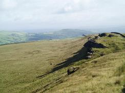
Cats Tor was soon followed by a visit to Oldgate Nick and the interesting stone outcrop of Pym Chair. This is not the only Pym Chair in the Peak District; there is another one on Kinder Scout, so I wonder about the veracity of the stories about how it was named. One of these is that Pym was a highwayman who used to watch from Pym Chair and then ambush the packhorses (led by man known as Jaggers). Another story is that Pym was a local preacher, who used to preach from the rocks. I daresay that he could have been a highwaymen and a clergymen (like Deacon Brodie in Edinburgh), but it is hardly likely! The path soon led down to the road near to the Pym Chair car park, and I had a quick chat to a couple who were setting off on the walk along the ridge. Surprisingly they were the first walkers that I had seen that day, and I had been expecting the ridge to be busier, particularly at that time of the day, but I was more than happy to have it all to myself. The map showed that I had to follow the road northwards for a little over a kilometre, but fortunately there was a path running alongside the road on the other side of the stone wall. This led past the western edge of the Goyt Forest before reaching the spectacular Windgather Rocks.
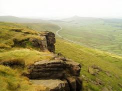
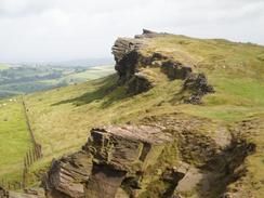
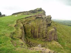
The crags of Windgather Rocks are very popular with climbers, and it is easy to see why. Although the crags are not as impressive as those at The Roaches further south, they are still dramatic, and I explored and took photographs for a few minutes whilst walking along them. Again the area was deserted, and I really could not understand why - it was a superb morning for a walk. The crags ended too soon, and I had a short, gentle walk along Taxal Edge - which is sans crags - to reach a farm. Here I turned to walk eastwards downhill along a footpath that soon met the northern end of the Goyt Forest and followed this all the way downhill to meet the Midshires Way near Cold Overton Farm. I had walked a long way along the Midshires Way further to the south yesterday, and it felt nice to be on the trail once again. This part of the way follows a track southwards through the Goyt Forest; initially it twists and turns to get across Mill Clough and past the farm at Oldfield, but after this it became a gentle amble southwards through the forest.
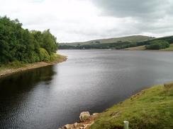
Unfortunately the trees more or less blocked any views that I may have had of Fernilee Reservoir, and I only managed to grasp a short glimpse of the dam through the trees near Oldfield Farm. It was a nice walk but after the highs of the early morning it was slightly disappointing, and I was glad when I reached a road called The Street. I joined this and followed it southeastwards towards the dam of the higher Errwood Reservoir, and here I had to make a decision. It was very tempting to leave the Midshires Way and follow it eastwards towards Buxton, before climbing back uphill to the Cat and Fiddle Inn. This would give me several advantages, but would be quite a long walk for a day in which I had a three-hour drive home. Alternatively I could continue on and walk to Cheeks Hill, Staffordshire's highest point, and after a little deliberation I decided to do the latter course of action. The road initially passes a car park, and I then discovered hat the road is shut to most traffic on Sundays during the season; this would make the walk uphill much more interesting without traffic.
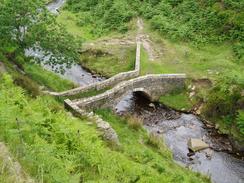
The road passes the side of Errwood Reservoir, which I got much better views of then Fernilee Reservoir, before climbing slowly uphill along the Goyt Valley. In the valley near Goytsclough Quarry there is an old packhorse bridge; this used to further downstream, but was rebuilt here when the reservoirs were built. In 1670 a gentleman called Thomas Pickford from the village of Adlington, Cheshire, had his estate confiscated by Cromwell, and he turned to road-mending instead. Stone was taken from the Goytsclough Quarry, and the packhorses were given alternative loads for their return journeys. This was the origins of the Pickfords removals firm; before today I had no idea that the company was so old! A little further upstream I was tempted to follow Berry Clough, but I decided to stick to the road so that I would visit Derbyshire Bridge. I stopped off in the car park at the bridge for a little rest, and started chatting to a cyclist who was also sitting at the table. Derbyshire Bridge used to mark the border of Derbyshire and Cheshire until the border was moved slightly further to the west in the sixties.
It was tempting to sit down for a little longer, but the weather looked as though it was getting worse, with the wind blowing a traffic cone about the car park. I therefore soon headed off, heading eastwards uphill for a kilometre before turning southwards along a footpath to reach the A54 road. I crossed this, and then took another footpath south across Axe Edge Moor. These were exceptionally easy to follow, and I enjoyed the easy and untaxing walk to Cheeks Hill. This is precisely on the Derbyshire / Staffordshire border, and marks the highest point of Staffordshire. I stopped here on a stile for a short period, and enjoyed the realisation that I had just reached another, unplanned, county top. It was a supremely satisfying feeling, and although this top was nowhere near as spectacular as Shining Tor had been earlier in the day, I felt far better about this one. From Cheeks Hill the footpath led downhill, joining a small Clough that slowly got deeper as we headed southwards. After a while the footpath became a track, and this became surfaced as it turned to head westwards. This surprised me, as there was no surfaced road marked on the 1:25,000 scale Ordnance Survey map that I was using. When the track diverted off to the left I headed straight on along a footpath that I enjoyed intensely as it headed towards Three Shires Head.
Three Shires Head is, as the name may suggest, the place where three counties (Derbyshire, Staffordshire and Cheshire) meet up, and is marked by a nice stone packhorse bridge over the River Dane. It may seem to be a peaceful spot nowadays, but historically it has been used for prize fighting, even after it had been made illegal. The village of Flash, which is known as Britain's highest village, is a short distance away to the south, and got its name from counterfeiting money (flash was the name given to the material cut off the edge of gold coins). I find it quite strange that such a beautiful spot could have seen counterfeiters and prize-fighters. I did not stop to admire the location for two reasons; firstly, I was so near the end of the walk and I wanted to get it finished, and secondly, the weather was starting to close in. And indeed, as I headed northwards following the western bank of the River Dane it started to slowly but surely drizzle. Fortunately it was only a light shower, but a glance overhead showed me that the weather could turn at any minute.
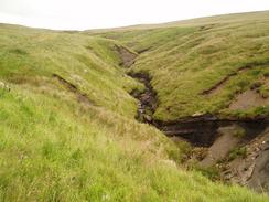
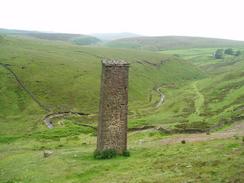
It was whilst I was following the Dane northwards that I came up with one of my tempting-the-gods comments. I had gone through the entire day without getting my boots muddy (due to the good paths or tracks that I had been walking along), and I was just thinking to myself that I would not have to clean my boots after the weekends walk when, of course, I hit a boggy area of ground. I have always thought of myself as being somewhat of a mud magnet, and this occasion proved to be no exception, and I was soon striding through annoyingly gloopy mud. I passed a group of walkers on the way who told me that it was also muddy up ahead, but fortunately it proved to be a lot better than the worse section of path. All this coincided with a heavier shower, and as I struggled up the steep slope to the A54 road, passing a ruined building and a graceful chimney on the way. I found this last climb of the day to be quite stressful, and I stopped just above the chimney to give myself a breather and take a couple of photographs down the valley.
Once across the A47 the going became far easier, as a wide and well-surfaced bridleway lead across Danebower Hollow. In the distance I could see a figure and I tried to speed up to see if I could catch up with him, a game that I play occasionally, but as time went on it became obvious that it was a forlorn hope. I could see the Cat and Fiddle pub for a long time before I reached it, and I was surprised to see that the car park, which was virtually empty when I set off, was now full. When I finally arrived at my car I dropped my bag off, and instead of tackling he long drive to Cambridge immediately, went into the pub to have a drink of orange and lemonade. The pub is a Robinson's pub, and I was pleased to see that they sold bottles of Old Tom. This is one of my favourite beers and is extremely hard to find down south, so I bought myself a couple of bottles to savour when I got home. I really did not want to face the drive back to Cambridge, but after twenty minutes I stood up and stretched, ready for the three-hour drive home.
Directions
This walk starts off at the Cat and Fiddle Inn, which is high on the moorland beside the Buxton to Macclesfield road. There is a small amount of car parking on the roadside beside the pub, but I do not know how the pub owners feel about walkers using their main car park. Head west down the A537 until you come to a left-hand bend. On the apex of the bend, follow a path that goes straight on. After 250 meters there is a split in the track; follow the branch that heads off to the north-northeast.
Go over a stile and shortly there is a gap in the wall, through the gap there is a path that heads to the northwest up towards the top of Shining Tor. Once at the top a ladder stile leads over a wall and over to the trig point; the path, however, turns to follow the wall northwards beside the wall. The path is easy to follow (although sometimes muddy), which slowly descends northwards, before ascending once more up to Cats Tor. After Cat's Tor, follow the path downhill until it ends at a minor road near Pym Chair. When you reach the road, follow it westwards for a few yards to a car park and a road junction.
At the road junction turn to the right, and follow the road as it heads northwards past a little car park. After a short distance a footpath (not marked on the map), starts on the right-hand side of the road; follow this as it follows the road northwards. When the path meets the western edge of the Goyt Forest it starts to angle slightly away from the road, and when the Windgather Rocks are reached it goes between them and the woodland. A much better walk, however, can be found by walking along the very edge of the Rocks; a spectacular and annoyingly short walk.
Once the Windgather Rocks subside farmland leads on northwards along Taxal Edge until a track is met by a farm. Turn right along this track and follow it for a short distance uphill to the east; fairly soon it peters out, and a distinct path continues on heading towards the edge of the woodland. Once it meets the woodland it heads downhill to the east, crossing Taxal Moor Road before reaching Overton Hall farm. Here the route that I followed joins the Midshires Way, which will be followed for the next few miles. The track heads for about a hundred yards eastwards past the farm, before another track leads off to the right, heading southwards downhill past Madscar Farm and into Mill Clough.
The track crosses Mill Clough and climbs eastwards out of it to Normanwood. Here the track turns to head southwards, heading for a couple of miles through the forest, passing a little farm at Oldfield before eventually reaching a road called The Street. Once the road is met, turn left and start following it as it heads downhill to the southeast, passing a car park on the way. Once the bottom of the hill is reached at a road junction the Midshires Way is left, and turn right along a road that follows the western bank of Errwood Reservoir to Shotter's Clough Bridge, where it starts to slowly start the climb uphill southwards along Goyt's Clough.
Goyt's Clough becomes narrower as it heads uphill, and after a couple of miles from the end of the reservoir it reaches a car park at Derbyshire Bridge. At the bridge turn left, and start following another track (actually the old Macclesfield to Buxton road) as it heads uphill to the east. After a kilometre a footpath is met, turn right and follow this as it heads southwards for a little less than a kilometre across Axe Edge Moor until he A54 is reached. Carefully cross the road, and once on the other side take a rough track that heads uphill to the south across Axe Edge Moor for another kilometre, until a road is reached near Dane Head.
At the road turn right and head downhill for a few yards, before turning off to the left to head southwards along a footpath. This footpath passes over Cheeks Hill (the highest point in Staffordshire), and crosses the border between Staffordshire and Derbyshire. The path continues on in a rough southerly direction, and fairly soon joins a track that runs along the western edge of a small stream. Near Orchard Common the track becomes surfaced, and slowly curves to head westwards, again following the stream. Near Orchard Farm the track winds off to the left; here turn right to a small bridge over the stream, and then turn left along a track that heads in a rough southwesterly direction.
This track is an enjoyable little stroll, and it ends at the River Dane at Three Shires Head. Cross the bridge over the river, and once on the other side turn right to start following a track uphill to the north. The track soon becomes a path, which follows the river northwards to the east of a little farm at Holt. At the head of the valley there is a ruined building, and soon after this a steep climb uphill starts towards a prominent chimney in the distance. The path passes the chimney and crosses a little track, before continuing on even steeper until eventually the A54 is reached. Cross the road, and once on the other side a distinct track leads off to the northwest across Danebower Hollow. After about a kilometre, the track curves to the right, to head northwards for another kilometre, back to the A537 road and the Cat and Fiddle Inn.
Distances
| From | To | Distance (m) | Ascent (ft) | Descent (ft) |
|---|---|---|---|---|
| Cat and Fiddle Inn | The Street | 7.6 | 1007 | 1531 |
| The Street | Cat and Fiddle Inn | 9.6 | 1804 | 1280 |
This makes a total distance of 17.2 miles, with 2811 feet of ascent and 2811 feet of descent.
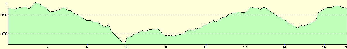
For more information on profiles, ascents and descents, see this page
Disclaimer
Please note that I take no responsibility for anything that may happen when following these directions. If you intend to follow this route, then please use the relevant maps and check the route out before you go out. As always when walking, use common sense and you should be fine.
If you find any information on any of these routes that is inaccurate, or you wish to add anything, then please email me.
All images on this site are © of the author. Any reproduction, retransmissions, or republication of all or part of any document found on this site is expressly prohibited, unless the author has explicitly granted its prior written consent to so reproduce, retransmit, or republish the material. All other rights reserved.
Although this site includes links providing convenient direct access to other Internet sites, I do not endorse, approve, certify or make warranties or representations as to the accuracy of the information on these sites.
And finally, enjoy your walking!
Nearby walks
| # | Title | Walk length (miles) |
|---|---|---|
| 1 | Shining Tor and Cat's Tor from the Cat and Fiddle pub | 7.2 |
| 22 | The Limestone Way from Matlock to Pomeroy | 16.9 |
| 23 | The Limestone Way from Pomeroy to Castleton | 14.0 |
|
|

|