Walk #615: Harlow to Edmonton via Epping Forest
 |
 |
|
General Data
| Date Walked | 17/07/2004 |
| County | Essex, London |
| Start Location | Harlow Town |
| End Location | Edmonton |
| Start time | 08.31 |
| End time | 15.55 |
| Distance | 19.4 miles |
| Description | This was a surprisingly nice walk, the highlight of which was the secluded walk through Epping Forest. |
| Pack | Today I carried my 30-litre Karrimor HotRock rucksack, which was filled with my waterproof leggings, water bottle, trainers and a couple of spare shirts, together with the usual assortment of odds and ends. It weighed slightly more than usual as I also carried a couple of litres of extra water. |
| Condition | The underside of my feet were aching after this walk, but aside from this I felt fine. I had no trouble with my ankle, and my legs were fine despite the fact that I had not done any walking for a couple of weeks. |
| Weather | Today's weather was very changeable, starting off with sunshine and cloud. This was followed by a very heavy thunderstorm with large raindrops falling to an accompaniment of thunder, but after this it started to dry out once more and by the end of the walk the sun was shining once again. |
| OS map | Landranger number 167 (Chelmsford, Harlow & Bishop's Stortford), Landranger number 166 (Luton & Hertford, Hitchin & St Albans) and Landranger number 176 (West London, Rickmansworth & Staines) |
 |
 |
|
 |
 |
|
Map of the walk
Maps courtesy of Google Maps. Route for indicative purposes only, and may have been plotted after the walk. Please let me have comments on what you think of this new format. For a detailed table of timings for this walk, please see the table file.
Notes
It was difficult for me to decide which walk to do today; Sam needed the car to drive some friends to Ipswich, and so I would have to rely on public transport to get me to the start and end of the walk. I have had the idea to do a walk through Epping Forest for some time, and a quick look at the map showed a good route, starting at Harlow and heading southwards to Epping, before entering the forest. Having decided this I was faced with getting to Harlow, and so Sam kindly drove me down to the station in Great Shelford in time for the quarter to eight train towards London. The journey took about half an hour, a journey that I spent mostly repacking my rucksack and agitatedly fiddling with various bits and bobs; a sure sign of the nervousness and impatience that I get when waiting for a walk to start.
By the time I arrived at Harlow Station I was getting quite hungry, as the early starts had meant that I had not eaten any breakfast or - horror of horrors - had a coffee, which is truly a heinous way to start a day. As I knew that I had a long walk ahead of me I was keen to get some food, so I stopped off at the little shop that is within the station. Whilst there the man behind the counter asked me if I wanted any corks for my hat; an inane comment that I get every so often, and one I usually respond to with the truth that the Tilley hat is actually Canadian. Unfortunately this did not really seem to convince him, and he would firmly not believe that the hat was not an Australian one, sans corks. When I did start to get the message through to him he seemed to think that I was saying that *I* was a Canadian, and so started a rather convoluted conversation: "This hat...", "Yes?", "Is made by a Canadian Company", "yes", "And I am English", "Okay. Do you want any corks?". Sheesh. Eventually I bought four chocolate bars and walked out. And no, I did not see any corks on sale.
Once outside the station I switched my GPS on and let it detect the satellites. This took much longer than it normally does, and I wandered around the forecourt until it eventually tracked four satellites and gave me a lock. This allowed me to set off, and I headed southwards through Harlow. The route that I had chosen did not go through the very centre of the town, and instead diverted along peripheral roads that were anything but scenic. For this reason I was quite glad when, after a couple of fairly dreary miles, I reached the point where this stretch of road walking ended and a bridleway took over, heading southwards. This was near to a large Asda store, and I was surprised to find that the bridleway was actually an old surfaced single-track rod, which despite having no traffic along it (and indeed looked as though it has had no traffic for some time) still had a pavement running alongside it. This made for a reasonable enough walk and it was relatively quiet, and this led me to feel much better about my choice of walk for today.
The surfaced bridleway ended at the A1169 road, and I was forced to join footpaths that headed southwards from here. First I had to get past a little school, and fortunately I found a little sunken lane that allowed me to get past the fenced-off playing fields. I then followed a nice footpath that headed south, slowly climbing up past Rye Hill. Unfortunately in one place the narrow path went through a wooded section, an din this section a large tree had fallen. I found that I could not fit under it, so I was forced to climb over it, using the branches as if they were rungs of a ladder - all good and well until a couple of them broke under my weight. This footpath eventually emerged out at a road, and this soon led on to another stretch of easily navigated footpath that headed past Orchard Farm before ending at another road.
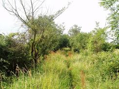
Directly across this road another footpath led off across some fields, zigzagging slightly as it headed southwards. The path across the fields was not obvious, but all of the stiles were well marked and this allowed me to find my way without getting lost. Once I reached the end of a track the footpath headed southwards across a field; I climbed the stile into the field and soon found the path totally obliterated by crops with extremely thick stems. The route of the path was easy to see as it dissected a set of power lines at the other edge of the field, but I found progress through the crops to be next to impossible. After about fifty yards, and with the stems of the crops wrapped around my ankles, I turned around and headed north to the edge of the field. Unfortunately this offered no way around the crops as they were planted right up to the hedge, so I headed back to the stile and walked down the track instead.
The track brought me out at the B1393 road just to the north of Epping. I followed this road southwestwards into the town, which I found to be a very pleasant place. Amazingly this was my first time in Epping; I had lived in South Woodford, which is a few miles to the south, for a year when I was eighteen and at University, yet I had never travelled the extra few stops up the Central Line to Epping. The town was bustling, and it was very clean and tidy; I took an instant liking to it. There was a bakery shop in the high street that enticed me within the doors, and I bought myself a couple of hot sausage rolls and a bottle of coke as I was running out of water; stupidly I had only taken a small bottle with me. When I ordered the food they offered me a free doughnut, so I walked down the road merrily chomping on the food.
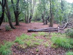
Some rumbles of thunder bought me from my sugar-induced high as I left the town. The distant thunder was soon followed by the rain, and by the time I entered the northern edge of Epping Forest. The rain was literally bouncing off the surface of the road, and I was glad that I had put my coat on at the first clap of thunder. My coats kept my body dry, but I had not bothered putting my waterproof leggings on and my trousers were soon well and truly saturated. I walked on into the forest, despite taking one wrong turn that led me back out after a hundred yards, and under the tree cover I was thankful to find that the rain was not as bothersome. The paths through the forest were actually broad and well-surfaced tracks, and this allowed me to make good time as I headed southwestwards, my head bowed down to protect my head from the worst of the rain. After a short while I came across a group of ramblers who had given up their walk for the day, they were heading towards me with disconsolate looks on their faces. I knew exactly how they felt, but I knew that giving up was not an option and that I had to continue onwards.
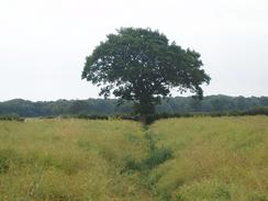
I had not really known what to expect of Epping Forest, as I had only been in the southern outskirts of it for short periods over twelve years before with some friends. I was pleasantly surprised to find that it made for a nice walk, and it was hard to believe that I was so near London. The forest itself is surprisingly ancient, and was believed to have become established in around 8,000 BC, shortly after the last Ice Age ended. It is nearly 6,000 acres in extent, and is home to all sorts of animals, including squirrels, of which I saw many and were surprisingly tame, and deer, which I did not see any trace of and I therefore conclude are far from tame. In 1878 the Forest became property of the Corporation of London, and it was dedicated to the use and enjoyment of people for all time. This has led to it being preserved, and it is now the largest open space near any capital city in the world that has never been ploughed or cultivated. For more information on the forest, see Epping Forest History. One of the more interesting facts is that an iron age hill fort within the forest, Ambresbury Banks, is reputed to be the place where Queen Boudicea had her last stand against the Roman governor Suetonius Paulinus
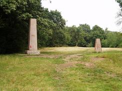
The walk was so enjoyable that time flew by, and after helping a Dutch couple who were hopelessly lost get back on track I emerged out of the forest onto Pole Hill, a nearby golf course being the first signs that I was coming back into civilisation. By this time the rain had thankfully stopped, and this allowed me to relax a little. The views south from Pole Hill were quite expansive, and the whole of eastern London was laid out in front of me. I sat down at the trig point for a few minutes and slowly absorbed the views, before walking over to the adjacent obelisk to study it. I was fascinated by the plaque on it, which read "This pillar was erected in 1824 under the direction of the Reverend John Pond, M.A., Astronomer Royal. It was placed on the Greenwich Meridian was its purpose was to indicate the direction of true north from the transit telescope of the Royal Observatory. The Greenwich Meridian as changed in 1850 & adopted by international agreement in 1884 as the line of zero longitude passes 19 feet to the east of this pillar.". I found this absolutely fascinating, and it led me to wonder whether the trig pillar that I had been sitting by marked the new meridian. I stood up, and in the distance to the south I could just about make out Greenwich. Yet another example of unexpected history encountered on a walk.
Eventually I pulled myself away from the view and descended downhill off Pole Hill, eventually emerging from the woodland into a dreary street, which led down to an even drearier A110 in Chingford Green. After the lovely walk through the forest I was not looking forward to the walk through East London, and the early sights reinforced that opinion. A minor highlight was a still extant fountain provided by the 'Metropolitan Drinking Fountain and Cattle Trough Association', which were once commonplace but now quite rare. The walk led on westwards towards the east London Reservoirs. The road led directly between King George's and the William Girling Reservoir, and although I had been hoping to walk along the bank of the former high, spiked metal railings guarded it. This was a shame, and instead I trudged along the road as it slowly started to spit once again.
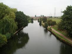
On the western side of the reservoir I passed over the River Lee navigation, a canal I had walked along seemingly years before as part of my Land's End to John O'Groats walk. I was tempted to visit the canal side pub, but despite it being in easy view there was no safe way down to it from the raised road. Frustrated I walked on further into deepest, darkest East London, until I reached the junction with the A1010 road, and sunk into the White Hart pub. I got some suspicious looks as I entered the pub from the barmaid, but once I had taken my Tilley hat off she became slightly more welcoming. As I was going by train I could have had a pint, but they had no decent bitter on tap and so I was forced to reluctantly settle for a pint of orange and lemonade. It is the sort of pub that I really do not like; it was a busy city-centre style pub, with large screen for showing sports or, at this time of day, music videos. There was very little character to the pub, and I soon realised I could have just as easily been in Manchester. It was a depressing place, made more so by the cigarette smoke that drifted over to me from the couple of women sitting nearby.
Eventually I had had enough, and I put my pack on, said an unacknowledged 'thank you and headed off down the road. I have through worse urban areas, and there were some signs of local colour, but my heart was really not in it. I felt oddly out of place, my pack and clothing separating me from the people who surrounded me, be they mothers pushing prams or men with obvious signs of that strange attribute commonly known as Bling. I walked southwards into Edmonton, an area that did nothing to improve my mood, and I suddenly decided to stop at Silver Street railway station. I had exceeded my planned twenty miles for the day, and I could not see the walk getting any better if I walked any further.
The decision to end the walk was quite fortuitous, as it turned out that purely by chance I had arrived at the station a couple of minutes before a train was due - quite handy when there is only one train an hour. I hurriedly bought me ticket and ran up the stairs, arriving about a minute before the train. This gave me a little time to look back at the day's walk, which had been varied in the extreme. The last third of the walk outside the forest had not been particularly nice, but the rest of it had been well worth doing, so I cannot really complain too much.
Directions
This walk starts off at Harlow Town railway station, on the northern side of the town. Leave the station and walk across the forecourt and past the bus shelters, to join a little path that heads southwards for about a hundred yards before it reaches the A414 Edinburgh Way. Once at the A414 turn right and walk westwards for a few yards to a large roundabout, and then turn to the left to head southwards along Fifth Avenue. At a roundabout continue straight on for a few yards to another roundabout, and then head straight on down Central Avenue to another roundabout.
At this roundabout the road is finally left behind; head straight on, crossing an old helipad marked on the grass before descending downhill along a surfaced path past Nettleswell Plantation. After crossing a stream the path starts to ascend uphill, curving uphill past a playing field before passing the end of Tendring Road. It then skirts southwards past a school and a sports ground before joining a track and ending at the A1169 Southern Way. Cross the road, and once on the northern side turn right past a green area, before turning left along an unsurfaced track that heads southwards past some playing fields before ending at Commonside Road.
Turn left to head northeastwards along Commonside Road for about a hundred yards, before turning to the right along a footpath that starts to head southwards. It soon leaves the built up area, and heads along the western edge of a narrow edge of woodland before joining the Stort Valley Way for a few hundred yards, before ending at a road. At the road turn left and follow it southwards; when it turns sharply to the left head straight on along a footpath that parallels a track alongside a hedge, passing Orchard Farm before ending at a minor road.
Cross the road and once on the other side continue straight on along another footpath, which twists around across fields in a rough southerly direction, initially heading southwestwards. A little over a mile later after the road the footpath meets the end of a track; the footpath heads across a field to the right, but due to impassable crops I headed down the track to reach the B1393 road. Turn right and head southwestwards to enter the town of Epping. Follow the road as it passes through the centre of the town, and shortly after it leaves the town turn left down a road at a hotel that heads southwards.
After a couple of hundred yards opposite a road junction turn right and follow a footpath across a gap between woods towards a playing field. Just as the edge of the field is reached, turn left and enter the woodland along a broad track that enters Epping Forest. The directions through Epping Forest are quite confusing; all the paths that I followed were nice and broad, but there were occasional branches that required careful checking on my Ordnance Survey map to check which one I had to go down. The route I took led me past Ambresbury Banks, an iron age hill fort, before heading south to cross the B172 and climbing up Jack's Hill. After this it turned to head southwestwards, crossing the A121 and heading onwards through the forest. Once a minor road is crossed the track takes a more obvious southwestwards course, passing some ponds and reaching the A104 road a short distance afterwards.
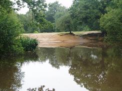
Cross the A104, and on the other side heads straight on westwards along another broad track. This crosses another track, and then curves to the left to head on a more south-southwesterly course; just before a lake is reached turn right along another track, that leads westwards for about half a kilometre to a road to the south of Sewardstonebury. At the road turn right to head northwards along it for about fifty yards, and then turn to the left along another track that heads westwards through some trees. The path passes a golf course on the left, and then slowly curves to the left to head southwestwards, eventually emerging out of the trees into a clearing by a trig point and a graceful obelisk. Pass the obelisk, and then head southwards down Pole Hill, and when the path eventually emerges from the trees and ends at Pole Hill Road, head straight on downhill to reach the A110 road.
At the A110 turn right and follow the road as it heads northwestwards for about half a kilometre until it reaches a crossroads with the A112. Cross over the A112, and continue straight on along the Lea Valley Road, crossing over the Lea River before passing between the large banks that hold in the waters of the King George's Reservoir to the north and William Girling Reservoir to the south. When the road leaves the reservoirs behind it crosses over the River Lea Navigation, and heads on to a large roundabout with the A1055.
Cross over the A1055 and continue straight on along the Lea Valley Road. This soon becomes Nags Head Road, which curves to a more westerly curse before reaching a crossroads with the A1010. Once at the crossroads turn left and start following the road as it heads southwards. After a couple of miles the road enters Edmonton and passes the railway station and a large shopping centre. Continue on southwards for another kilometre until the junction with the A406 North Circular Road is reached. Turn right and walk westwards for about a hundred yards until Silver Street railway station is reached, where this walk ends.
Distances
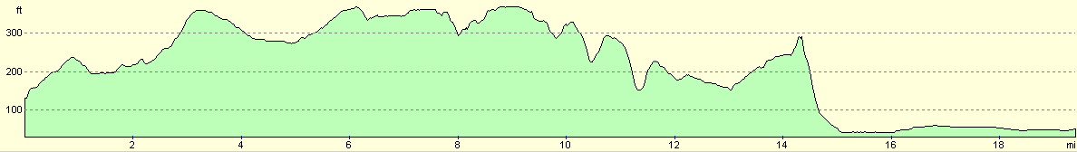
| From | To | Distance (m) | Ascent (ft) | Descent (ft) |
|---|---|---|---|---|
| Harlow Town Station | Epping | 6.7 | 410 | 200 |
| Epping | Pole Hill, Chingford | 7.6 | 472 | 531 |
| Pole Hill, Chingford | Silver Street Station, Edmonton | 5.1 | 69 | 302 |
This makes a total distance of 19.4 miles, with 951 feet of ascent and 1033 feet of descent.
For more information on profiles, ascents and descents, see this page
Transport
There are fairly regular train services between Silver Street station in Edmonton and Harlow Town, changing at Cheshunt on the way.
Disclaimer
Please note that I take no responsibility for anything that may happen when following these directions. If you intend to follow this route, then please use the relevant maps and check the route out before you go out. As always when walking, use common sense and you should be fine.
If you find any information on any of these routes that is inaccurate, or you wish to add anything, then please email me.
All images on this site are © of the author. Any reproduction, retransmissions, or republication of all or part of any document found on this site is expressly prohibited, unless the author has explicitly granted its prior written consent to so reproduce, retransmit, or republish the material. All other rights reserved.
Although this site includes links providing convenient direct access to other Internet sites, I do not endorse, approve, certify or make warranties or representations as to the accuracy of the information on these sites.
And finally, enjoy your walking!
Nearby walks
| # | Title | Walk length (miles) |
|---|---|---|
| 50 | Paddington to Mile End | 8.3 |
| 51 | Mile End to Enfield Lock | 12.7 |
| 52 | Enfield Lock to Harlow Town | 12.6 |
|
|

|