Walk #616: Cotswold Way: Bath to Tormarton
 |
 |
|
General Data
| Date Walked | 24/07/2004 |
| County | Avon, Gloucestershire |
| Start Location | Bath Station |
| End Location | Tormarton |
| Start time | 09.50 |
| End time | 17.52 |
| Distance | 18.2 miles |
| Description | This was an enjoyable stroll heading north out of Bath, with some superb views westwards towards the Severn estuary from this southern edge of the Cotswold escarpment. |
| Pack | Today I carried my 75-litre Craghoppers Rucksack. I did not carry my camping gear, but I did have more other assorted gear with me, which made up for most of the weight of the camping gear. |
| Condition | I was very tired by the end of today's walk, not only because of the early start and the long trip to get to Bath, but also because of the strenuous walk that followed. The underside of my left foot was exceedingly sore by the time that I finished, and my shoulders ache a little, but aside from these I seem to have got away lightly. |
| Weather | The weather today was superb for walking - a combination of light cloud, sun and a stiff breeze that helped to keep me cool. There was no sign of any rain, for which I am thankful. |
| OS map | Landranger number 172 (Bristol & Bath, Thornbury & Chew Magna) |
 |
 |
|
 |
 |
|
Map of the walk
Maps courtesy of Google Maps. Route for indicative purposes only, and may have been plotted after the walk. Please let me have comments on what you think of this new format. For a detailed table of timings for this walk, please see the table file.
 |
Notes
This walk was the first day of my walk along the Cotswold Way, a stroll that I only decided to do about a month ago, when it became obvious that there were a few days' holiday that I needed to take from work. Initially I planned to walk the Ridgeway National Trail, but I ended up deciding against this for a couple of reasons; initially because the Ridgeway is just about doable as day walks from my home in Cambridge with difficulty, but mainly because I realised I could take a few extra days off and end up with eight or nine days walking. When I realised this my mind settled on walking up the Cotswold Way, and then walking on for another three days northwards along the Heart of England Way.
Consequently my alarm clock woke me up at five a.m. this morning, and with bleary eyes I got up and made myself a coffee. I did my final amount of packing, and I realised with alarm that even though I was not carrying a tent or the associated paraphernalia, my pack seemed to weigh as much as usual. Instead of the tent I was carrying my trainers, a couple of battery chargers and a few books; all this added up to an equivalent weight to my tent and sleeping bag! Part of the aim of this walk was to enjoy myself, and as the Cotswolds are hardly camping territory it made sense to stay in B&B's instead.
Sam kindly drove me the half-mile to Shelford Station to catch my train, which arrived punctually. I read as I travelled down to Liverpool Street Station on a train that was initially empty but soon started to fill up as a seemingly endless chain of stations passed me by. A quick tube journey and I soon found myself ordering a coffee as I waited for my train. Eventually the platform was announced, and I was surprised to find a Class 180 waiting for me - I had been expecting a HST's, which were once mainstays of this route, and I entered the 180 with some curiosity, as I had never been in one before. Unfortunately the first thing I noticed as I entered the carriage was the smell of the toilets, the smell of which could clearly and nastily drifted into the corridor.
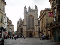
With my nose wrinkled I found my seat and got ready for the 90-minute journey to Bath. As the countryside rushed by (only interrupted by the astonishing fact that the massive Oracle complex in Reading has its own car wash) I chatted to a nice gent and read a book. Tiredness was starting to claim me, so I bought a Red Bull, which helped me keep awake until I reached Bath Spa Station. I had been to Bath a couple of time before as part of my Land's End to John O'Groats walk, but I had never actually gone into the historic city centre, my previous walks having taken me to the south of the centre. I was therefore looking forward to the walk into the centre and the official start of the Cotswold Way. I was not disappointed - the buildings that I passed were beautiful, and my speed through the city was reduced as I spent more time looking up at the facades than downwards.
My initial target was the tourist information office in Bath, which I soon found with a shock. The shock was induced by the Abbey Church in Bath, a magnificent building that is right beside the Tourist Information office. I went in to the office and bought a guide to the Cotswold Way and an accommodation guide I had all the maps with me, but in some places the route was unclear and so I Hoped that the guide book would clarify these areas. The Cotswold Way is due to become an official National Trail next year, so a great deal of upgrading work is being done to it before then, and the official guide is out of print. There was, however, a very good unofficial guide, and I bought that instead.
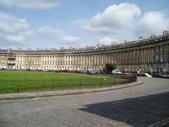
Outside the Tourist Information office I was greeted with my first problem. The Cotswold Way begins from outside the Abbey Church, but I could see no signs proclaiming the start or pointing out of the area. A quick glance at the map showed that the official route did not pass by the Royal Crescent, which I really wanted to see, and so I decided that I would start the walk by doing a slight diversion through the city to see this. The architecture as I passed through Bath was truly superb; as a whole the town seems to shine because of the Cotswold Stone that all the buildings seemed to use.
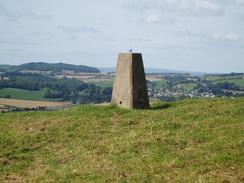
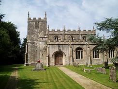
The Royal Crescent did not disappoint me, as it is a superb semi-circle of fine Georgian buildings that are in much better condition than the similar ones in Buxton. I wandered around the front of the building enjoying the architecture, before heading off to rejoin the Cotswold Way proper by a golf course. Here I saw my first Cotswold Way sign - a seemingly brand new one with National Trail acorn symbol on it. This was a nice sight, and I followed it uphill, stopping only to use the public toilets situated beside one of the greens. The way emerged from the golf course onto the road at Sion Hill, and then headed along roads and paths, passing the church in Weston. There then followed the first really rural stretch of the walk, a short climb up a recreation ground to reach a trig point on Penn Hill. The path was separated from the trig pillar by a fence, and whereas normally I would be over the fence to examine the pillar at closer quarters (evidently as someone already had, as it was sporting a bottle on top of it), I decided to be content with just photographing it from a distance.
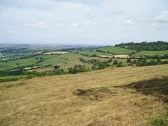
This did not disappoint me too much, as I soon found myself following a track that led on to the trig pillar on Kelston Round Hill. Here the Cotswold Way diverts around the eastern side of the little hill, although a concessionary path leads up to the trig pillar and I used this to climb up to the pillar. What immediately surprised me were the expansive views; and I was amazed to see that I could see the towers of both of the Severn bridge away in the distance, a sight that I would be able to see on and off from the high ground for the next three days. The pillar was in a quite exposed location and I soon started to feel cold in the wind, so I headed down back to the Way and headed along towards Little Down Iron age hill fort. On the way I passed Prospect Stile, where I stopped to admire the view and chat to some ramblers who were standing by the topograph. I did not mention that I was walking the entire way; I really do not like mentioning things like that until I have got some real distance under my belt. The path took me on past Bath racecourse, which has a commanding position on the hill. Beside the racecourse I had to limbo under some railings that were placed at a nasty height - too low me to crawl under easily with my pack, and too high to climb over.
A walk across a golf course took me to Hanging Hill and my third trig pillar of the day, and whilst trying to photograph this I got stung by some of the nettles surrounding it. Right beside the pillar there is a stone monument and a flagpole commemorating the Battle of Lansdown on the 5th July 1643. In this battle the parliamentarian forces, led by Sir William Waller, defended the hill from the royalist forces of Lord Ralph Hopton. The royalists eventually won the hill after three attacks, although a Cornish regiment commander for the Royalists, Sir Bevil Grenville, died in the battle. A short distance further on along the escarpment I came across the Grenville monument, which was erected in 1643 to commemorate the heroism of Grenville and his pikemen. This was protected by railings, and after taking some photographs I headed off on the long walk up to Cold Ashton. This was an attractive little village, and Cold Ashton Manor in particular was a superb building that was well worth photographing.
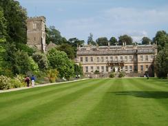
By this time I was starting to feel quite tired, and as I could see a pub marked on the map beside the A420 I decided to try and stop there for a rest. The pub turned out to be the White Hart Inn, and I was lucky to get there when I did - it was due to shut in forty minutes time. I settled down to have a pint, and followed this up by a half of orange and lemonade to help refresh me for the rest of the journey. The pub was not very busy and there was no one to chat to (the landlord being particularly uncommunicative), and so I read the guidebook whilst I waited for the pub to shut. Once I restarted the walk I headed across fields to the A46(T) at Pennsylvania, and then across more fields to get to the little village of Dyrham. The Way heads through the village along roads, and then skirts the edge of Dyrham Park, a National Trust property. Through some gates I could just make out the dramatic baroque styling of Dyrham House, although access was denied unless I paid the National Trust's entry fee. I walked on out of the village, passing some strip lynchets on the way to Hinton Hill.
From here the Way headed northwards along paths, excepting a short stretch of road walking, and skirted the edge of the Beacon Hill Plantation before reaching the A46 once more. The Way was well waymarked as it crossed the A46, and once on the other side I got confused as the way markers pointed me in a direction contrary to those in the guidebook and on the OS map. I figured that as part of the upgrade of the Cotswold Way to National Trail status, there have been recent route changes in the area, and so this proved. The path headed across fields and was exceptionally well waymarked, and took me out onto a road near to Lower Lapdown Farm. This road led me north across the M4, which was bustling with cars, and on into the village of Tormarton. With hindsight this would have been a nice place to finish for the night, but my B&B was a short distance off the way to the north, near to Old Sodbury.
The batteries of my GPS ran low when I reached the church at Tormarton, so I sat down for a couple of minutes on a low stone wall whilst I waited for the unit to reacquire the satellites. This little rest did me some good, and when I got up to restart the walk my feet felt much better. I strode on down the road, crossed another road and continued on towards my B&B. When I had booked the B&B I had entered the postcode into Streetmap and it had pointed at one large house standing on its own. As I reached the house, however, something did not look right. The lack of a B&B sign did not worry me, as many B&B's do not have them, but there 2was also no name board. I was expecting a Windylands, and I would have assumed that any B&B owner would have had the sense to actually let people know which house they lived in. I rang the doorbell, and when a man answered the door he pointed out that Windylands was actually the next house on the left, a half-mile walk away. It roved easy to find, and I was soon upstairs in a twin bedroom, lying on one of the beds, totally knackered.
The proprietors of the B&B told me that the nearest hostelry was 400 yards, down the road, so I decided to have a little soak before starting the stroll for an evening meal. When I got to the Cross Hands Hotel I was quite excited - they sold Abbott Ale! This, for those of you who do not know the history of Abbott and myself, is a strong beer that somebody once told me you could not drink six pint of in a day. Well, a couple of years ago Terry and myself reached six pints but at great cost to our health and sanity - I left the Eagle in Cambridge (being picked up by an understandably annoyed Sam) after having invited a couple of Germans over to stay. To avoid any such problems this evening I limited myself to just two pints, and enjoyed a superb chicken meal in a white wine sauce, before walking back to the B&B and retiring to bed.
Directions
The majority of this walk follows the Cotswold Way, which is a well waymarked path that is soon to become a National Trail. I used a guidebook for the walk called 'The Cotswold Way', by Mark Richards (see below). This guidebook is written for north to south walkers and therefore the directions are not quite as useful for the south to north walk, but the hand-drawn strip maps are exceptionally good, and can be read easily from either direction. There was a recreational path guide published for the route, but this is out of print and will only be re-issued as a National Trail Guide once the path has officially become a National Trail.
The exceptions to this are at the beginning and end of the day's walk. Initially I had to walk from Bath Spa railway station to the start of the Way by the Abbey, but as the route was not well waymarked I made my own way for the first mile, passing the Royal Crescent. Leave Bath Station, and then head northwards straight up the A3039 Manvers Street ahead towards the town centre. This soon becomes Pierrepont Street, and when a roundabout is reached turn left and then almost immediately left again to reach the abbey, tourist information and Roman Baths. Continue on past the baths, and then turn right along a road that swings to the left before ending at a T-junction with Stall Street. turn right up Stall Street, and when this ends turn left into Westgate Street and follow this westwards until it meets a complex junction with Monmouth Street. Turn right, to head northwards uphill along Barton Street until it meets the eastern side of Queen Square. Continue on uphill passing Queen Square, and then up Gay Street to reach the wonderful buildings of The Circus. Walk a third of the way around The Circus to reach Brock Street, and follow this across a road junction to pass the Royal Crescent. On the western side of the crescent turn right to head uphill along Marlborough Buildings for a shirt distance, and then take the first road to the left. The Cotswold Way can be reached a short distance along this road, by the entrance to a golf course on the right.
From Tormarton at the end of the day I took a different route, as my B&B was not on the Way. When the way reaches St Mary Magdalene Church in Tormarton, instead of following the Cotswold Way as it heads westwards, continue straight on northwards along a road. After a couple of hundred yards a road junction is reached; continue straight on for about a mile until the B&B that I stayed at, called Windylands, is reached on the left. If you are not staying there you would be best to ignore these instructions and follow the Cotswold Way proper to Old Sodbury.
| If you wish to buy the guidebook for the Cotswold Way that I used, then please click on the link to the right: | 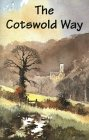 |
Distances
| From | To | Distance (m) | Ascent (ft) | Descent (ft) |
|---|---|---|---|---|
| Bath Spa Station | Bath Abbey | 0.4 | 23 | 3 |
| Bath Abbey | Cold Ashton | 10.0 | 1795 | 1198 |
| Cold Ashton | Tormarton Church | 6.6 | 587 | 715 |
| Tormarton Church | Windylands B&B | 1.2 | 79 | 43 |
This makes a total distance of 18.2 miles, with 2484 feet of ascent and 1959 feet of descent.
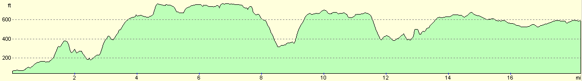
For more information on profiles, ascents and descents, see this page
Accommodation
I spent the night at the Windylands B&B, Tormarton Road, Old Sodbury, South Gloucestershire BS37 6RP, telephone (01454) 323653. This was a very nice and welcoming B&B, which cost me thirty pounds for the night, and it gave me a good night's sleep. There is a very nice pub/hotel a few hundred yards down the road, the Cross Hands, which gave me a very nice evening meal.
Disclaimer
Please note that I take no responsibility for anything that may happen when following these directions. If you intend to follow this route, then please use the relevant maps and check the route out before you go out. As always when walking, use common sense and you should be fine.
If you find any information on any of these routes that is inaccurate, or you wish to add anything, then please email me.
All images on this site are © of the author. Any reproduction, retransmissions, or republication of all or part of any document found on this site is expressly prohibited, unless the author has explicitly granted its prior written consent to so reproduce, retransmit, or republish the material. All other rights reserved.
Although this site includes links providing convenient direct access to other Internet sites, I do not endorse, approve, certify or make warranties or representations as to the accuracy of the information on these sites.
And finally, enjoy your walking!
Nearby walks
| # | Title | Walk length (miles) |
|---|---|---|
| 72 | Bath to Devizes | 19.3 |
| 126 | Farrington Gurney to Bath | 12.6 |
| 617 | Cotswold Way: Tormarton to Dursley | 19.9 |
|
|

|