Walk #617: Cotswold Way: Tormarton to Dursley
 |
 |
|
General Data
| Date Walked | 25/07/2004 |
| County | Avon, Gloucestershire |
| Start Location | Tormarton |
| End Location | Dursley |
| Start time | 08.41 |
| End time | 18.28 |
| Distance | 19.9 miles |
| Description | This was a superb walk, taking in some of the highest points in the Cotswolds with some fantastic views over the plains to the southwest. |
| Pack | Today I carried my 75-litre Craghoppers Rucksack. I did not carry my camping gear, but I did have more other assorted gear with me, which made up for most of the weight of the camping gear. |
| Condition | I am very tired after this walk, and was quite relieved when I finally managed to find the B&B. I have a mark on my right side where a part of my rucksack has dug in, but the underside of my feet ache less than they did last night and I generally feel better. |
| Weather | The weather started off as a slightly windier version of yesterday, with much sunshine and a few thin clouds. As the afternoon drew on however, so did the cloud, and it started to drizzle fairly persistently. This was never heavy enough to force me to put my coat on, but was enough to annoy. |
| OS map | Landranger number 172 (Bristol & Bath, Thornbury & Chew Magna) and Landranger number 162 (Gloucester & Forest of Dean) |
 |
 |
|
 |
Map of the walk
Maps courtesy of Google Maps. Route for indicative purposes only, and may have been plotted after the walk. Please let me have comments on what you think of this new format. For a detailed table of timings for this walk, please see the table file.
Notes
I woke up fairly evening this morning, as the two gents staying in the room next door were leaving at 5.30, a time that is early even for me. Fortunately I had gone to sleep early, and so I was not as tired as would otherwise have been the case. Breakfast was at seven, and I packed my kit up at a leisurely pace before hitting the road a little before nine. A short stretch of road walk took me down to the Cross Hands pub, where I had eaten last night, and this was followed by a track then took me up a hill, before descending down into the little village of Old Sodbury. I walked along to the church, which I took a few photographs of before heading back to the waymarked path. As I did so a brand-new car nearly backed straight into me; if I had not stepped put of the way it could have hit me, although it was not moving too fast and the damage would have been minimal. The driver wound his window down and apologised, explaining that he had not yet got used to his new car. He also said he was a rambler, and we exchanged a few words about the beauty of the local area. At least if he had hit me I could have contented myself with the fact that he liked the countryside.
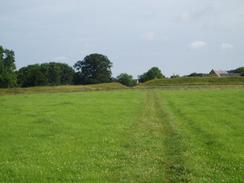
The path climbed out of Old Sodbury to reach a fantastic place - a double-banked old fort called Sodbury Camp, a 17-acre Bronze to Iron age site. This seemed to cover a massive area, and I wondered who lived there in ancient times. It was really an impressive and inspiring sight, and I walked across the flat area between the banks with my imagination in full flow, daydreaming of the people who had lived there and the battles that they mat have fought. The path descended down off the hillside to reach Little Sodbury, and this was followed by a fairly ordinary stroll northwards to Horton and towards Horton Court, where the Way headed up back onto the escarpment. The views from here were far better and I enjoyed the stroll along towards a large monument that I had been able to see for some time. I was tempted to climb up to the top of this, but I resisted the temptation and continued on along the path. This soon left the road and headed northeastwards before descending steeply to Lower Kilcott; near the top of the ascent I chatted for a few minutes to a nice Asian lady who was walking the Cotswold Way from north to south.
When I reached Alderley I decided to have a little break, and so I sat down on the verge in the village and watched the traffic to go by, which on this quiet Sunday morning consisted of three horses! I did not spend long there, and I soon got up and walked the easy mile across fields to Wortley, after which I was faced with a long and steep climb up a green lane up Wortley Hill. I found this to be quite a tough section, and I was very relieved when I reached the top. The views were nearly non-existent due to the woodland that surrounded the path, and I soon found myself joining a road for the long descent down into Wooton-under-Edge. Again there were no views to speak of, and it left me wondering why the creators of the Way had chosen to take us up this largely unnecessary hill.
Wooton-under-Edge was an attractive little town, and I decided to divert off the path slightly to find a pub where I could have a drink. The area around the church was totally devoid of any pubs, so I walked on a short distance where the attractive Falcon Inn tempted me in. The interior was very welcoming, and I ordered a pint of Doom Bar (a beer that I have not had since I was last in Padstow in Cornwall, seemingly a very long time ago) and a pack of crisps. I found a table and sat down to listen to the end of the German Grand Prix on my walkman. This proved to be quite engrossing, and so another pint soon followed the first, and when the race finished I chatted to some of the locals for a while, before reluctantly leaving. I immediately went the wrong way when I left the pub, although I soon realised this and headed back onto the correct route. The Cotswold Way was not very well signposted through the town, and I went the wrong way once more (again, only for a short distance) before I found the correct route that led uphill into some woodland. Of course, I would never say that my inability to find the correct path through the town was anything to do with the two pints that I had!
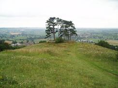
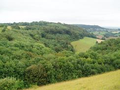
The route through the woodland was very broad and easy to follow, and was quite busy with people walking with their children. I would have thought that the views from the path westwards would have been brilliant, but the thick tree cover prevented all but the briefest glimpses down. Eventually I reached the end of the trees, and as I walked northwestwards towards the tall Tyndale monument the views to the southwest were breathtaking. The monument was built in 1866 to commemorate the life of William Tyndale, who was a prominent Protestant during Henry VIII's reign, and produced the first complete English translation of the New Testament. From the base of the monument I could clearly see both Severn bridges in the distance, and the river Severn was also clearly visible on the plain below. It was definitely a place to pause for a few minutes before tackling the steep descent down a path into North Nibley. Here the drizzle started with a vengeance, although this was not heavy enough to force me to put my coat on. The path headed northwards out of the village, and just before I crossed the B4060 I met a couple that were heading in the opposite direction and staying in the village overnight. They warned me that the next ascent up onto Stinchcombe Hill was very steep, and they were correct. It was a killer of an ascent for tired kegs, and so instead of pushing myself I took a more relaxed ascent onto the summit.
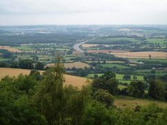
The views from the trig point a the top of Stinchcombe hill were great, although slightly spoilt by the sound of the M5, clearly visible and audible below. The top of the hill is dominated by a golf course, and even after five in the evening people were still playing rounds. The Cotswold Way follows the edge of the plateau avoiding the course for most of the time, although there were some footpath diversion orders plastered everywhere which indicates that the route may be changing in the near future. It took me longer than I expected to reach the clubhouse, where the Cotswold Way heads steeply downhill through some woodland to reach Dursley.
I took the descent down from the hill slowly, as it was steep and my legs were quite tired from all the walking. I sped up once the footpath met the road, and I set out trying to find the B&B that I had booked for the night. The landlady had warned me that, although it was near the path, the B&B was quite hard to find, and this proved to be the case. I walked up one road to look for the place, and when I could not fund it I headed back toward the library, when a local directed me along a path that headed uphill towards a health centre. Again I could not find the place, so I ended up phoning the landlady again and being directed to yet another path that eventually led to the B&B, which I arrived at with great relief. I had been walking around the town for over twenty minutes, and added a mile to the length of my walk just in the process of trying to find the B&B (not included in mileage below), which was doubly annoying as it should have been easy to find. Once I got to my room I had a long soak, and then retired to bed without going out to dinner; I was that tired.
Directions
The majority of this walk follows the Cotswold Way, which is a well waymarked path that is soon to become a National Trail. I used a guidebook for the walk called 'The Cotswold Way', by Mark Richards (see below). This guidebook is written for north to south walkers and therefore the directions are not quite as useful for the south to north walk, but the hand-drawn strip maps are exceptionally good, and can be read easily from either direction. There was a recreational path guide published for the route, but this is out of print and will only be re-issued as a National Trail Guide once the path has officially become a National Trail.
|
The exceptions to this are at the beginning of the day's walk. Initially I had to walk from the B&B that I stayed in at Windylands to join the Cotswold Way in Old Sodbury. This was a very easy route to find; simple leave the B&B and walk northwards until the road ends at the A46(T). Turn right and walk for a hundred yards to a complex road junction by the Cross Hands Hotel. Once at this junction turn left along the A432, but then turn immediately to the right to climb uphill along a minor lane that leads westwards, before descending downhill to meet the Cotswold Way in Old Sodbury. If you wish to buy the guidebook for the Cotswold Way that I used, then please click on the link to the right: |  |
Distances
| From | To | Distance (m) | Ascent (ft) | Descent (ft) |
|---|---|---|---|---|
| Windylands B&B | Old Sodbury Church | 1.1 | 95 | 213 |
| Old Sodbury Church | Alderley | 8.0 | 955 | 1115 |
| Alderley | Wooton-under-Edge | 3.8 | 656 | 79 |
| Wooton-under-Edge | Dursley | 7.0 | 1345 | 1345 |
This makes a total distance of 19.9 miles, with 3051 feet of ascent and 2752 feet of descent.
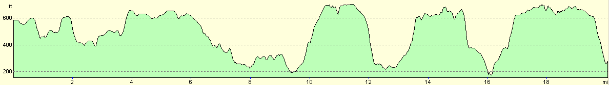
For more information on profiles, ascents and descents, see this page
Accommodation
I spent the night at a lovely little B&B in Dursley, which was run by a nice Swedish lady. It cost me £22.50 for the night, and there was a sumptuous breakfast. The only downside was that when I came to make my coffee this morning the milk had gone off and a large lump dropped into my coffee, but this as probably my fault for not keeping it cool overnight.
Disclaimer
Please note that I take no responsibility for anything that may happen when following these directions. If you intend to follow this route, then please use the relevant maps and check the route out before you go out. As always when walking, use common sense and you should be fine.
If you find any information on any of these routes that is inaccurate, or you wish to add anything, then please email me.
All images on this site are © of the author. Any reproduction, retransmissions, or republication of all or part of any document found on this site is expressly prohibited, unless the author has explicitly granted its prior written consent to so reproduce, retransmit, or republish the material. All other rights reserved.
Although this site includes links providing convenient direct access to other Internet sites, I do not endorse, approve, certify or make warranties or representations as to the accuracy of the information on these sites.
And finally, enjoy your walking!
Nearby walks
| # | Title | Walk length (miles) |
|---|---|---|
| 616 | Cotswold Way: Bath to Tormarton | 18.2 |
| 618 | Cotswold Way: Dursley to Painswick | 16.7 |
|
|

|