Walk #618: Cotswold Way: Dursley to Painswick
 |
 |
|
General Data
| Date Walked | 26/07/2004 |
| County | Gloucestershire |
| Start Location | Dursley |
| End Location | Painswick |
| Start time | 09.06 |
| End time | 16.49 |
| Distance | 16.7 miles |
| Description | This was a fairly strenuous walk, with some superb views to be had but also much woodland walking. |
| Pack | Today I carried my 75-litre Craghoppers Rucksack. I did not carry my camping gear, but I did have more other assorted gear with me, which made up for most of the weight of the camping gear. |
| Condition | The worst problem that I have had today is chaffing behind my left ankle, which was red raw and bleeding by the time that I reached Haresfield Beacon. I have never had problems with this part of my foot before, and I have put a large strip plaster over it to try and protect it for tomorrows walk. |
| Weather | Today was another mixed-up day, with some periods of sunshine intermingled with longer periods of cloud. It did rain fairly heavily at one stage, but I was about to enter some woodland which protected me from the worst of it and I did not bother putting my coat on. It was quite warm despite the cloud, and all in all the weather could have been much worse. |
| OS map | Landranger number 162 (Gloucester & Forest of Dean) |
 |
 |
|
 |
 |
|
Map of the walk
Maps courtesy of Google Maps. Route for indicative purposes only, and may have been plotted after the walk. Please let me have comments on what you think of this new format. For a detailed table of timings for this walk, please see the table file.
 |
 |
|
Notes
I awoke this morning quite energised despite yesterday's strenuous walk, and I very much looked forward to another great day's walking. The lady who runs the B&B is Swedish, and she cooked a delicious breakfast for me - everything was cooked perfectly, and it was by far the best B&B breakfast that I have had for some time, and it set me up well for the day. After getting ready to go I ended up chatting to the landlady for a while - it turns out that she had lived in Cambridge many years before and we talked about the area; one of the nicest things about staying in B&B's as opposed to camping is the way you meet such nice people, whereas when you camp it tends to be a fairly solitary affair.
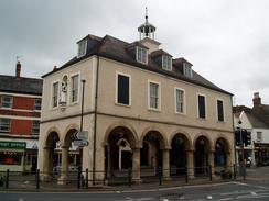
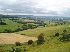
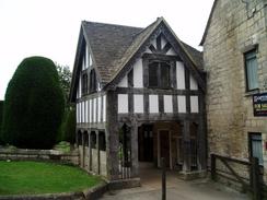
The way marking through Dursley was not the best, although I was pleased that the path passed the superb pillared Market House, originally built in 1738, but now acting as the town hall. This building reminded me somewhat of the market hall in Winster in Derbyshire, and it must act as a wonderful focal point of the town. Near the bottom of the hill it was not very obvious which route I should take near the Lister engine works, although I managed to guess correctly. The first hill was a reasonable climb, and the gradient soon flattened out allowing me to speed up as it crossed some fields. Ahead of me, however, I could see my first challenge - Peaked Down (also called Cam Down), which is a peaked hill. The National Trail signs pointed up the hill, so I slowly climbed up the precipitous side of the hill, resting at the top to take in the superb views. I could not afford to rest for too long, however, as I had a descent to make before climbing once more to reach the top of Cam Long Down. This was not as steep as Peaked Down, but it was still a bit of a puff to reach the top. The walk along the top of the down was very hummocky, and I enjoyed looking at all the views as I strolled along it.
On the descent down from the hill I stopped to chat to a gent who was walking up it, and it turned out that he was a volunteer warden for the Cotswold Way. Apparently the 'official' route will, when it is opened, take a different route avoiding Peaked Down, but the whole Way is not due to open as a National Trail until late 2005 at the earliest. This came as a surprise to me as I had read some literature that showed that it was going to be opening this year; it is now obvious that the literature is out of date. Annoyed at my slightly unnecessary climb, I started the ascent back up through Coaley Wood. The path rose and fell, but I eventually found myself at the viewpoint on Frocester Hill, where I stopped for a minute to take in the superb views. A little way further on near the car park there was the remains on an opened long barrow called Nympsfield Long Barrow, with the stones standing guard at the entrance way.
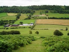
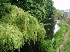
More woodland walking followed, along good paths and tracks through Stanley Wood. The path rose and fell, exiting the woodland for a short section near a farm before plunging back in. On this stretch it started to rain, and although I was tempted to put my coat on I sped up and got under the tree cover again before I got too wet. By the time I had followed the path past Pen Hill and emerged from the trees once more to enter the little village of Middleyard the rain had stopped, and I decided to stop for a few minutes rest on a seat near a chapel. The rest was very welcome and I could have stopped for longer, but I sill had a long way to walk today and so I got up and followed the trail as it skirted past the village of King's Stanley to reach the A419 road. I had to cross this carefully, and once on the other side the way almost immediately crosses a canal, something that I had not been expecting to do on this trip.
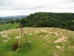
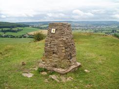
A long ascent then followed, initially crossing a railway line on a footbridge before climbing up to Westrip and then Maiden Hill. At the top of the hill the Way entered yet more woodland, and the path rose and fell gently as it headed through Standish Wood. Eventually the path emerged from the woodland at a car park, and the views suddenly became superb as it curved around to a viewpoint on a little promontory. I admired the views from here for a short while, before heading on along the curved path that led towards Haresfield Beacon. Annoyingly the path descended for a short distance before climbing uphill once more, to eventually lead out to the trig pillar on the hummocky promontory. The trig point marks the halfway point of the walk, and it seemed like a good place to take the last break of the day. For the last few miles the back of my left ankle had been hurting, and I used the opportunity to take a look at it, and I was shocked to find that it had been rubbed so raw that it was now bleeding. I washed it off as well as I could, and I let it dry off before putting an inch-long strip plaster over it - hopefully this will protect it over the next few days.
From the trig point the path was quite easy, with none of the stiff gradients that had annoyed me this morning. The path curved around to meet a road at Cliffwell Cotts, before ascending and entering woodland for the walk northeastwards to the A4173 at Edge. I was very tempted to nip into the Edgemoor Inn for a drink, but I successfully resisted the temptation and continued on the final descent of the day, down a hill to a stream. Needless to say this was followed by another ascent, and I was quite relieved when I emerged out into the outskirts of Painswick.
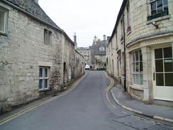
Unlike the travails of last night I found the B&B easily, and I enjoyed the walk through this delectable village, which is surely the nicest that I have seen so far in the Cotswolds, with rosy stone buildings and a relatively unspoilt character. The landlady let me in, and after she had shown me my room she made me some tea and we had a long chat in the living room. One thing that I have noticed today is that I am walking the route quite fast - apparently most people do the Way in seven or eight days, and I will hopefully be completing it in five and a half, which I am quite proud of considering the weight that I am carrying.
I went for a little walk this evening, settling on the Royal Oak for dinner; it proved to be full of character and I chatted to another couple of walkers who were staying at the same B&B and walking the Way in sections. It was by far the nicest night of the walk so far, and I savoured every moment of the evening. The village itself is fairly unique in my experience - a small instance of this is the fact that the gravestones in the local churchyard have brass plaques instead of engravings! It is definitely somewhere that I will visit again in the future.
Directions
|
This walk follows the Cotswold Way, which is a well waymarked path that is soon to become a National Trail. I used a guidebook for the walk called 'The Cotswold Way', by Mark Richards (see below). This guidebook is written for north to south walkers and therefore the directions are not quite as useful for the south to north walk, but the hand-drawn strip maps are exceptionally good, and can be read easily from either direction. There was a recreational path guide published for the route, but this is out of print and will only be re-issued as a National Trail Guide once the path has officially become a National Trail. If you wish to buy the guidebook, then please click on the link to the right: |  |
Distances
| From | To | Distance (m) | Ascent (ft) | Descent (ft) |
|---|---|---|---|---|
| Dursley | Middleyard | 6.7 | 1614 | 1591 |
| Middleyard | Haresfield Beacon | 5.6 | 978 | 571 |
| Haresfield Beacon | Painswick | 4.4 | 778 | 988 |
This makes a total distance of 16.7 miles, with 3370 feet of ascent and 3150 feet of descent.
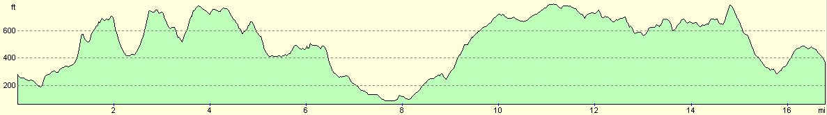
For more information on profiles, ascents and descents, see this page
Accommodation
I spent the night at the Thorne bed and breakfast, Friday Street, Painswick, Gloucestershire GL6 6QJ, telephone (01452) 812476. This was a beautiful house that was mainly a 17th Century Wool Merchants, but with two pillars of the Market Hall (built in 1400) in the dining room. It cost me thirty pounds for the night, and it was well worth the money.
Disclaimer
Please note that I take no responsibility for anything that may happen when following these directions. If you intend to follow this route, then please use the relevant maps and check the route out before you go out. As always when walking, use common sense and you should be fine.
If you find any information on any of these routes that is inaccurate, or you wish to add anything, then please email me.
All images on this site are © of the author. Any reproduction, retransmissions, or republication of all or part of any document found on this site is expressly prohibited, unless the author has explicitly granted its prior written consent to so reproduce, retransmit, or republish the material. All other rights reserved.
Although this site includes links providing convenient direct access to other Internet sites, I do not endorse, approve, certify or make warranties or representations as to the accuracy of the information on these sites.
And finally, enjoy your walking!
Nearby walks
| # | Title | Walk length (miles) |
|---|---|---|
| 617 | Cotswold Way: Tormarton to Dursley | 19.9 |
| 619 | Cotswold Way: Painswick to Dowdeswell Reservoir | 18.2 |
|
|

|