Walk #551: Rattray Head to Cruden Bay
 |
 |
|
General Data
| Date Walked | 09/09/2003 |
| County | Grampian |
| Start Location | Rattray Head |
| End Location | Cruden Bay |
| Start time | 07.45 |
| End time | 16.55 |
| Distance | 20.3 miles |
| Description | This was quite an enjoyable walk on an otherwise disappointing day. The long stretch of beach at the beginning and the cliffs at the end were particularly memorable. |
| Pack | Today I carried my 30-litre Karrimor HotRock rucksack, which was filled with my packed lunch, waterproof leggings, water bottle and a couple of spare shirts, together with the usual assortment of odds and ends. |
| Condition | I feel absolutely fine after this walk, and I could easily have walked further if I had needed to. Both of my feet were fine, and I had no trouble with any other part of my body. |
| Weather | The weather today was very nice for most of the day, with bright sunshine and very little wind. Towards the end of the day some black cloud came over, but fortunately they only deposited a few solitary drops of rain. All in all it was a lovely day for a walk. |
| OS map | Landranger number 30 (Fraserburgh, Peterhead & District) |
 |
 |
|
 |
 |
|
Map of the walk
Maps courtesy of Google Maps. Route for indicative purposes only, and may have been plotted after the walk. Please let me have comments on what you think of this new format. For a detailed table of timings for this walk, please see the table file.
 |
 |
|
Notes
Sam and I got up yesterday morning ready for breakfast, fully expecting me to do a walk. Rob and Val were being such lovely hosts however, that their offer to spend another day at the Rattray Head B&B was too tempting to miss. I was going to take a day off at Aberdeen anyway, so taking one off a little earlier was not too serious. Rob kindly allowed us to connect Mervan up to the mains, so I spent much of the day in Mervan getting the website up to date. This was punctuated by a couple of walks to the beach and back with Sam, when I took some panoramic photos. The entire day was massively enjoyable, and was by far the best day that I have taken off on the trip so far.
Yesterday Sam got a phone call from a local RDA group who wanted to meet up with us today in the middle of the afternoon, so we got up early this morning so that I could have an early start and get many miles done before then. Rob offered to make me a cooked breakfast, but I do not walk well immediately after a heavy breakfast, even if it is lovely, and so I made do with a bowl of cereal and a glass of orange juice. When this was over I said goodbye to Rob and Val, thanked them for their hospitality and set off over the dunes to the beach.
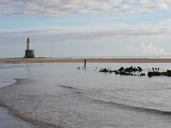
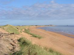
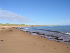
The tide was out when I clambered over the dune and descended down it onto the beach, and I cold just about have walked to the base of the lighthouse if I had wanted. I was tempted to do this but the rocks looked very slippy and were green with algae, so I just turned right and walked down the beach. The beach walk to Peterhead was quite long and was exceptionally memorable, with mostly sunny skies and some lovely views out to sea. I could see the lighthouse nearly all the way down to Peterhead, quite a long way. Shortly after I left I passed the large gas terminal at St Fergus, which we could see from our bedroom window lit up spectacularly in the dark over the last couple of nights. Much work was being done on the terminal, and I nipped up onto the top of a sand dune so that I could look at the work.
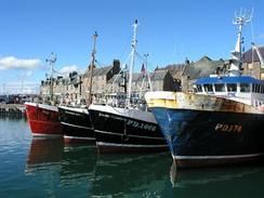
I managed to walk around most of Peterhead, and I must admit I quite liked the bustle of the busy fishing port. The town is dominated by the tall building of the Syncrolift ship lift, which has a 27 metre high by 15 metre wide door, and can take ships up to 41 metres in length, 10.5 metres beam and 6 metres draught. The building was quite impressive, and is the sort of thing that I see on this trip that I would love to have a look around. Chatting to a man in the B&B the other night who works in Peterhead the harbour is about half as busy as it was a few years ago as the fishing fleets are being reduced, but it seemed busy enough to me and was quite bustling as I walked through it.
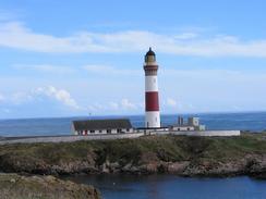
I managed to take quite a coastal route around Peterhead, and as I had planned to walk straight through I ended up adding quite a bit more distance on that I had been intending, which did not really matter. I soon found myself walking past the large Peterhead power station and on into Boddam, where I could not help but study the 1827-built lighthouse. This stands on a little island of rock called Buchan Ness, and is connected to the mainland by a concrete bridge. The lighthouse is of what I call the classical design, and looked very nice, although it is not in a very picturesque situation. At the harbour nearby a police underwater search unit were diving, and this led me to wonder if it was training or a real call-out. Sam met me in Boddam and she made me a couple of sandwiches for me to eat on the next stretch, and we arranged to meet three miles further on.
I did not get as far as I wanted on the next stretch, and we had to drive to meet an RDA group at two, so Sam met me at the junction of the A90(T) and A975 and we started the half-hour drive north to the group. The photographer that we met on Sunday was there to take some photos, and we ended up having a nice long chat to the members. This group showed exactly the same characteristics as all the other groups that we have visited on this trip; keen, hard-working individuals who give their time to this great cause. For more details of this group, see their website at www.buchanrda.org.uk.
My legs were stiff by the time that Sam dropped me off back at the road junction where I had finished the walk, I started on along the road towards the coast and after a few minutes I stepped onto the verge as a car came past. The next thing I know a black plastic bottle hits me on the knee as a Stagecoach bus drove by on the other side of the road. Kids were looking and laughing at the back window on the top deck, and I suddenly felt a sudden rage - the bastards had thrown the bottle out of the window at me. What sort of scum were they, throwing bottles out of windows? I can understand children' pranks, and no harm was done, but it really upset me.
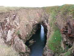
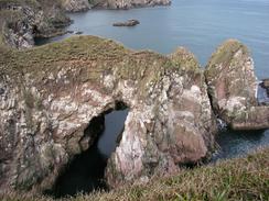
My mood improved slightly when I arrived at the Bullers of Buchan, a fairly amazing arch and amphitheatre 200 feet wide and 50 feet deep. The view was stunning, and I stood there for a few minutes soaking it in. Nearby was a sign stating that there was a footpath to Boddam, annoying as there was no path marked on the map and I had seen no sign of it in Boddam. This path would have saved me a long road walk, so missing it was doubly annoying. Fortunately south of the Bullers of Buchan there is a distinct path that took me along the top of the cliffs towards the ruins of Slains Castle. These cliffs are suerb, with several caves and rock arches to be seen, and it was the best clifftop walk that I have done for some time.
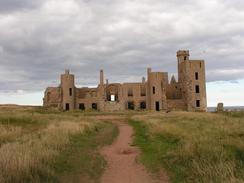
The ruins of New Slains Castle are just as impressive as the cliffs that surround them, and I walked in and through the castle, studying it. At one point I went down into a dark room that looked as though it may have been a kitchen, although it was hard to tell without a torch as it was quite dark inside. I loved being able to walk around such substantial ruins - I get the impression that it was not exactly the oldest castle in the world. The castle was an inspiration for Bram Stoker when he wrote Dracula, which is based on this castle and one in Whitby. When I got back to Mervan I found out that New Slains Castle (called new to separate it from the 'old' one that I shall pass further down the coast tomorrow) is older than I expected - it as altered in 1664, 1707 and 1836. With reluctance I left the ruins and continued on down the coast to Cruden Bay, where Sam was waiting for me.
The nights are really drawing in fast at the moment - it is getting dark before eight thirty, when a month ago it was well after ten before we had to shut the blinds. One advantage of this is that we get to see more spectacular sunrises and sunsets - over the summer in Scotland I did not see many as they were at ridiculous times in the morning and night. This is a sad sign that the walk is nearly over, and the effects will only slightly be reduced by the fact that I am heading south.
Directions
This walk starts off at the lighthouse cottages at Rattray Head. Leave the cottages and head eastwards through the sand dunes to the beach and lighthouse. Once on the beach turn right and head south along the beach for about seven and a half miles, passing the towers of a gas terminal before reaching Scotstown Head, Kirkton Head and eventually Craigewan before reaching the mouth of the River Ugie. At the mouth of the river turn right to head westwards for about a hundred yards to a concrete bridge over the river, called the George Birnie Memorial Footbridge.
Cross the bridge and on the southern side turn left to walk eastwards along a path beside the river. When this path ends at a road near on old spa well continue on southeastwards into the harbour area of Peterhead. I walked a little loop through the harbour walking along a road that led past a series of fish warehouses on the right before reaching a lift bridge over an entrance to the docks, by the extremely large building of the Syncrolift ship lift. This road soon ends at a T-junction with a public road; turn left and follow this road as it curves round past the RNLI station to meet the A982 road. Turn left to walk down he A892 for a short distance and then drop down onto a path that runs southward by the foreshore to a caravan site.
At the caravan site head southeastwards through a little car park before climbing uphill along a path that leads onto the top of the cliffs. This path skirts the northern side of Peterhead prison before dropping down to meet a road. Join the road and follow it southeastwards to Salthouse Head, where it curves around to the right to head southwestwards.
Near the end of a very large factory on the right and a house on the left turn left down a track that passes across a gap in an old railway embankment and runs south along the top of the cliff above Sandford Bay. The path ends near Sandford Lodge; a distinct path runs along the outside of the wall surrounding the lodge before dropping down onto a track that heads southeastwards under Peterhead power station before eventually joining the B9108 road above the harbour in Boddam.
Head southwards along the B9108 road towards the lighthouse on Buchan Ness, and just before the lighthouse is reached turn right down other roads that lead southwestwards to meet the A90(T) road. Turn left and follow the A90(T) southwestwards for about two miles until the junction with the A975 road is reached. Turn left to head southward for a mile down the A975 road until a car park is reached on the left.
At the car park turn left and walk down a track to the top of the cliffs. a few yards further north is the spectacular amphitheatre of the Bullers of Buchan; this is well worth a visit. Afterwards return to where you were and turn left to follow a distinct path that heads eastwards for a short distance along spectacular cliffs before turning to head southwards along the top of the cliffs.
The path ends by the ruins of Slains Castle; join a track that heads past the castle and continues on along the cliffs until a stream is reached, where the track turns to the right to follow the stream inland before eventfully crossing it and reaching a car park. Go through the car park and onto a road; turn left down this road for fifty yards to where there is another car park with some public toilets, where this walk ends.
Distances
| From | To | Distance (m) | Ascent (ft) | Descent (ft) |
|---|---|---|---|---|
| Rattray Head | Peterhead | 9.3 | 312 | 338 |
| Peterhead | Boddam | 4.3 | 384 | 367 |
| Boddam | Cruden Bay | 6.7 | 673 | 679 |
This makes a total distance of 20.3 miles, with 1369 feet of ascent and 1384 feet of descent.
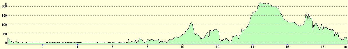
For more information on profiles, ascents and descents, see this page
Accommodation
We spent the night in a car park at Cruden Bay, which was nearly directly opposite the public toilets and was a quiet enough place to spend the night.
Disclaimer
Please note that I take no responsibility for anything that may happen when following these directions. If you intend to follow this route, then please use the relevant maps and check the route out before you go out. As always when walking, use common sense and you should be fine.
If you find any information on any of these routes that is inaccurate, or you wish to add anything, then please email me.
All images on this site are © of the author. Any reproduction, retransmissions, or republication of all or part of any document found on this site is expressly prohibited, unless the author has explicitly granted its prior written consent to so reproduce, retransmit, or republish the material. All other rights reserved.
Although this site includes links providing convenient direct access to other Internet sites, I do not endorse, approve, certify or make warranties or representations as to the accuracy of the information on these sites.
And finally, enjoy your walking!
This walk was mentioned in the following routes:
| My walk around the coastline of Britain |
Nearby walks
| # | Title | Walk length (miles) |
|---|---|---|
| 550 | Rosehearty to Rattray Head | 16.0 |
|
|

|