Walk #550: Rosehearty to Rattray Head
 |
 |
|
General Data
| Date Walked | 07/09/2003 |
| County | Grampian |
| Start Location | Rosehearty |
| End Location | Rattray Head |
| Start time | 09.55 |
| End time | 15.49 |
| Distance | 16.0 miles |
| Description | This was an absolutely superb walk, with lots to be seen and done as I walked along. |
| Pack | Today I carried my 30-litre Karrimor HotRock rucksack, which was filled with my packed lunch, waterproof leggings, water bottle and a couple of spare shirts, together with the usual assortment of odds and ends. |
| Condition | I feel absolutely fine after this walk, and I could easily have waked further if I had needed to. I had no problems with my feet, which was a relief. |
| Weather | Today was a very nice day, with strong sunshine and only a few clouds. Unfortunately there was quite a strong breeze, and this rather spoiled the walk along the beach in the afternoon. |
| OS map | Landranger number 30 (Fraserburgh, Peterhead & District) |
 |
 |
|
 |
 |
|
Map of the walk
Maps courtesy of Google Maps. Route for indicative purposes only, and may have been plotted after the walk. Please let me have comments on what you think of this new format. For a detailed table of timings for this walk, please see the table file.
 |
Notes
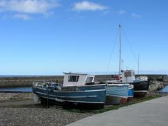
Sam drove me back to Rosehearty this morning, after I had spent a fair amount of time getting some work done on the computer at the campsite. Rosehearty looked superb in the sunshine, and as I got out of Mervan by the harbour a RIB was just getting ready to go out with a load of divers and their kit. I had a quick chat to one of the divers, who told me that there was some great diving to be had in the area - I told Sam this, and her instant reaction was to shiver at the thought of the cold water!
On the way to Fraserburgh I passed through the little village of Sandhaven. This is yet another classic fishing village, with lovely houses of the fairly unique brick and stonework style of this area. The harbour was not very busy, and the breakwater had a large gap in it where the sea had broken through it. It was quite a peaceful scene, and I could not help but stop for a couple of minutes to admire the view.
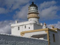
The approach to Fraserburgh was through a slightly industrialised area, although fortunately there was a coastal path for the vast majority of the way, and I only had to divert along a road where the coast path was closed due to erosion. I soon found myself at the Kinnairds Head lighthouse, which is quite an amazing structure - the bottom half of the lighthouse is the old Kinnairds Head Castle, which the Stevensons used as the base for the lighthouse. Adjacent is a lighthouse museum that I would not have minded visiting, but unfortunately it did not optn until midday and I had a schedule to keep to. Next door to the lighthouse is another strange building, which is locally called the 'Wine tower', although it may have an earlier history. This little area, stuck as it was between the harbour and an industrial estate, was a little gem, and I was very glad that I went to see it.
Fraserburgh Harbour was full with boats as I skirted around it, and I could not help but nip in through an area proclaiming no unauthorised persons to have a closer look. The area was quite busy and nobody batted an eyelid as I looked around at some of the boats in the harbour. They ranged in size from small trawlers to large factory ships, the latter looking far smarter and well kept in general than the former. I was not at all surprised to fins that the area smelled very strongly of fish, and I wondered how many tons of fish were brought in every week.
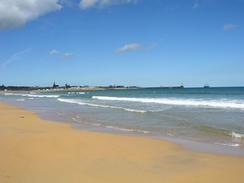
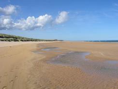
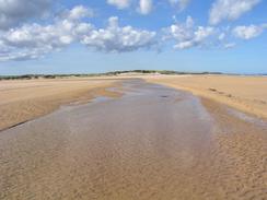
Sam was waiting for me at the Esplanade car park in Fraserburgh, which is beside the campsite where we spent last night. We had told a journalist that I would be at Rattray Head by four o'clock, so I could not have a long lunch and I was soon ready to set off once again. The next stretch of walk was along a lovely beach, although in places it was quite hard to find some hard sand to walk on. There were some sand dunes to my right, and the sand had a lovely red tint to it. Fortunately as the tide was going out I could cross the mouth of a stream - if the tide had been high I would have had to walk upstream a long way to the nearest bridge, and I soon found myself walking along minor roads past Cairnbulg Point and through the village of Inverallochy. More beaches took me past the golf course and on towards the little village of St Combs, which I continued past on the beach.
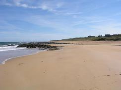
The stretch of beach along to Rattray Head was absolutely superb, and the views along the beach in either direction were stunning in the bright sunshine. I strolled along quite happy, although there was quite a fierce headwind that unfortunately spoilt this stretch of the walk. As I walked along the beach dune buggies roared past, the riders looking as though they were very much enjoying themselves. They became ever more numerous as I walked southeastwards along the beach, until eventually I was having one pass me every couple of minutes. It certainly seemed as though they were enjoying themselves, although it looked as though the sand dunes may have been suffering from their onslaught.
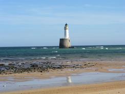
As I approached Rattray Head I had a phone call from Sam telling me that a photographer from a local newspaper was waiting for me. As I walked the last stretch Sam came towards me, and we posed for a few photographs as we climbed up a sand dune, with the attractive lighthouse in the background. This lighthouse sits slightly away from the shore on a large cylindrical stone base, and was supplied from the shore by a large-wheeled tractor at low tide. It protects The Skerries, and area of rocks just under the surface of the water where apparently many ships have been sunk over the years. Tonight was going to be quite unusual for us; well over six months ago we had an email from a gent who had very kindly offered us free accommodation at his B&B at Rattray Head, and that was our plan for tonight. I had covered sixteen miles today and was very tempted to walk on further, but I ended up chatting to the photographer in the tearooms attached to the B&B for an hour or so. The B&B is absolutely superb, and it was extremely kind of the owners to allow us to stay. It is based in the old lighthouse keepers cottages, and the room has not only a king-size waterbed but also a circular window from which he lighthouse can be seen.
This evening the owners took us out to a local hotel, The Strathbeg House Hotel, who were very kindly gave us a free meal. I had roast beef, which was the first time that I have had this for ages and was absolutely superb. The hotel was a very nice and friendly place, and can be contacted on (01346) 532857. This evening has been absolutely superb, and I cannot recommend the B&B highly enough, and Rob and Val have been marvellous hosts.
Directions
This walk starts off at the harbour in the little village of Rosehearty. Leave the harbour and walk south along he road, passing a municipal campsite and joining the B9031 road. Walk eastwards along this road for a little over three miles as it passes through Sandhaven and reaches the outskirts of Fraserburgh at Broadsea. When the B9031 road turns to the right to meet the A98 turn left across a grassy area and join a road that heads for a short distance to the sea by a waste recycling centre.
Here turn right and follow a path that runs along the seafront through Broadsea and past Clubbie Crag before curving around a little bay. The path ends in an industrial estate, and a road that parallels the sea can be followed past the lighthouse museum and to the lighthouse at Kinnaird Head.
Walk past the lighthouse and then turn right to walk down past the Wine Tower to the northern part of the harbour. Do not start walking along the breakwater but turn right and then left to head south along a road that passes in front of the harbour and eventually reaches a municipal campsite and the esplanade in the town. Here drop down onto the beach and follow it eastwards for a couple of miles until the Water of Philorth is reached. As the tide was not high I managed to cross this without getting my feet wet, but if it is high tide then you may need to walk upstream for nearly a kilometre to a bridge and back again on the other side.
Once across the water of Philorth continue on northeastwards as the beach becomes increasingly stony; I soon joined a little track that skirts the shore instead of walking along the beach. This track leads to a little boat haven near Cairnbulg Point, and then turns southeastwards to head into Inverallochy. Walk on a road through the village and on the southeastern side follow a path that runs between the golf course and the sea to gain access to Whitelinks Bay and eventually St Combs.
At St Combs the seashore is rocky, but I preferred to walk along this than to go through the village, and I soon reached a sandy area once more near Inzie Head. From here simply walk southwards and then southeastwards along the beach until the Rattary Head lighthouse is reached, and then turn right to go over the dunes inland for a short distance to the black and white old lighthouse keepers cottages, which is now a B&B / coffee chop and is where this walk ends.
Distances
| From | To | Distance (m) | Ascent (ft) | Descent (ft) |
|---|---|---|---|---|
| Rosehearty harbour | Fraserburgh lighthouse | 5.0 | 243 | 249 |
| Fraserburgh lighthouse | St Combs | 5.7 | 190 | 190 |
| St Combs | Rsttray Head | 5.3 | 161 | 131 |
This makes a total distance of 16.0 miles, with 594 feet of ascent and 570 feet of descent.
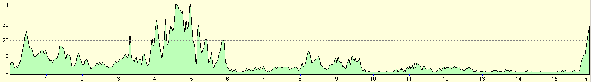
For more information on profiles, ascents and descents, see this page
Accommodation
We spent the night at the excellent Rattray Head B&B, Lighthouse Cottages, Rattray Head, Peterhead, Aberdeenshire AB42 3HB. They can be contacted on (01346) 532236 or by email at enquiries@rattrayhead.net, and they have a website at www.rattrayhead.net. I cannot praise highly enough this establishment, and the friendliness of it's owners, Rob and Val.
Disclaimer
Please note that I take no responsibility for anything that may happen when following these directions. If you intend to follow this route, then please use the relevant maps and check the route out before you go out. As always when walking, use common sense and you should be fine.
If you find any information on any of these routes that is inaccurate, or you wish to add anything, then please email me.
All images on this site are © of the author. Any reproduction, retransmissions, or republication of all or part of any document found on this site is expressly prohibited, unless the author has explicitly granted its prior written consent to so reproduce, retransmit, or republish the material. All other rights reserved.
Although this site includes links providing convenient direct access to other Internet sites, I do not endorse, approve, certify or make warranties or representations as to the accuracy of the information on these sites.
And finally, enjoy your walking!
This walk was mentioned in the following routes:
| My walk around the coastline of Britain |
Nearby walks
| # | Title | Walk length (miles) |
|---|---|---|
| 549 | Macduff to Rosehearty | 20.5 |
|
|

|