Walk #552: Cruden Bay to Bridge of Don
 |
 |
|
General Data
| Date Walked | 10/09/2003 |
| County | Grampian |
| Start Location | Cruden Bay |
| End Location | Bridge of Don |
| Start time | 07.37 |
| End time | 17.35 |
| Distance | 25.6 miles |
| Description | This was an absolutely superb walk, with some great long stretches of beaches to walk along, and some nice cliffs early on. |
| Pack | Today I carried my 30-litre Karrimor HotRock rucksack, which was filled with my packed lunch, waterproof leggings, water bottle and a couple of spare shirts, together with the usual assortment of odds and ends. |
| Condition | I feel absolutely fine after this walk, and I could have walked further after a little rest if I had to. The biggest problem was with my right shoulder, which ached after I tripped up late in the morning. |
| Weather | Today was another lovely day, with mostly sunshine and not many clouds to spoil the day. There was not much breeze, but it was a bit chilly first thing in the morning and there was enough breeze to make me glad of my fleece. |
| OS map | Landranger number 30 (Fraserburgh, Peterhead & District) and Landranger number 38 (Aberdeen, Inverurie & Pitmedden) |
 |
 |
|
 |
 |
|
Map of the walk
Maps courtesy of Google Maps. Route for indicative purposes only, and may have been plotted after the walk. Please let me have comments on what you think of this new format. For a detailed table of timings for this walk, please see the table file.
 |
 |
|
Notes
Despite sleeping quite well last night I was quite tired when I woke up, and it took me two cups of coffee to wake up even a little bit. I was quite keen to have another early start, and so I wrote up the directions for yesterdays walk and when Sam woke up I grabbed my bag and set off. Unfortunately in my haste I had forgotten that I had emptied my water bottle yesterday, and so I had to walk for the first seven miles with no water, not a great hardship early in the morning.
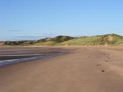
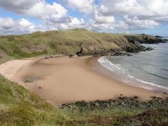
The initial couple of miles along the beach beside the Bay of Cruden was very nice in the early morning sunshine, although I was more than a little glad that I had put my fleece on as it was slight chilly for the first hour or so. The tide was coming in, and I found that the firmest sand was in a narrow band where the waves were coming in, and this meant that if I mistimed when a wave came in my feet would get wet. I had been warned that the cliffs south of Whinnyfold were quite dangerous, so instead I decided to follow the road southwestwards, which also allowed me to get a good speed up.
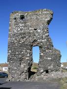
I diverted off the road to go and have a look at the Old Slains castle of which not much is remaining nowadays. This castle was the seat of the Earl of Buchan and Errol. In 1594 it was blown up by James VI after he discovered that the Earl of Errol had been involved with a plan to land Spanish troops on the coast - it took 20 stone of gunpowder to do the job. After this the Errol family moved to New Slains castle further north up the coast, which I passed yesterday. I was rather disappointed by the ruins, and especially as I could not get a decent photograph of it as the sun was low in the sky behind it. The rest of the way to Collieston was along a grassy path at the top of the cliffs, and this allowed my trainers, which had dried out on the long road walk, to get wet once again from the dew on the vegetation.
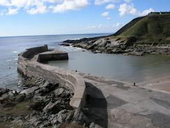
Sam was waiting for me in Mervan at St Catherine's Dub (named after the Spanish Galleon Santa Caterina which was wrecked there in 1594), and I went in to be greeted with a cup of coffee and some raisin toast - Sam being a star once again. I had walked over seven miles so it was a good time for a break, and due to the early start I could afford to relax a little. It is nice to have quite a few miles under my belt by that time in the morning, and this went a long way to the large distance that I walked today.
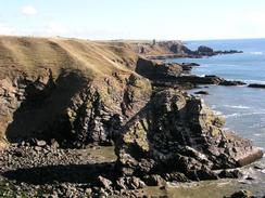
From Collieston I followed the edge of the cliffs southwestwards until they ended, and then onto Newburgh Point. The walk over the cliffs was superb - the cliffs are not too high, and covered in sand dunes that form the Forvia National Nature Reserve. It was a great walk, and I enjoyed it, especially as there was a good path that I could follow. Whilst heading down off the cliffs, however, my left foot went into a divot in the sandy path and I went downhill base over apex. I lay in a hap on the ground with my left foot and right arm and shoulder hurting, but fortunately no serious harm was done and I picked myself up, and continued on. Once down off the cliffs it was a simple beach walk down to the mouth of the River Ythan (this part of the reserve is a Ternery and is shut between April and August to allow the birds to nest in peace).
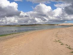
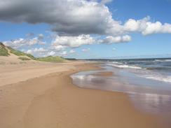
I met Sam at the Ythan Hotel in Newburgh, and I felt like I deserved to take a little more time off, so I had two pints and allowed myself the treat of a bake potato with beans and cheese - very nice. We had a nice chat with the barmaid which delayed the restart of the walk somewhat, but that did not matter, and the only reason I wanted to get off in a hurry was so that I could listen to the start of the Archers on Radio 4! I made my way through a golf course and back to the mouth of the River Ythan, from where I simply walked south along the beach for ten miles until I reached the River Don. The tide was quite high at the northern end of the beach but receding, which meant that as the afternoon wore on an ever-increasing expanse of sand became visible. There were sand dunes to my right for the entire ten miles, and I came across a bird on the beach that was preening itself. It allowed me to get close which was unusual so I took a photo of it, and it even did not seem bothered when I touched and stroked it. It was very strange to see such a tame bird, and it made me wonder why it was so tame.
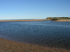
I was quite relieved as I reached the mouth of the River Don, as I was suffering from what I could probably describe as 'beach fatigue' - the beach had gone on for mile upon mile with low dunes to the right. As I rounded the corner, however, I was quite amazed to see tower blocks on the south side of the river - I can hardly remember the last time that I saw any of them, and it made me quite sad as it is yet another sign that I am getting into far less remote territory.
Directions
This walk starts off at the car park beside the public toilets in the village of Cruden Bay. Turn right for a short distance towards Port Erroll and then turn right to cross a footbridge over a little stream and onto the beach, and walk south along the beach for a couple of kilometres. At the southern end of the beach a path leads uphill onto the top of the cliffs, and winds around outside the fields before ending at a road in the little village of Whinnyfold. Head northwestwards along this road for a few hundred yards until it ends at a T-junction with another road, and then turn left to head southwestwards along another road.
Follow this road for nearly three miles as it passes West Sandend and Newclochtow, and shortly after a road junction on the right turn left up a track that heads southwards for a few hundred yards to the farm at Mains Slains. At the farm turn left down another track that heads eastwards towards the ruins of the Old Slains Castle. Just before the castle is reached turn right along a path that follows the fence line at the top of the cliffs southwestwards for a little over a mile until it descends down steps to a car park in an old disused quarry at St Catherine's Dub. Cross the car park and take a footpath that leads on around some cliffs to a pier and into Collieston.
Pass the little harbour and then take a path that leads steeply uphill; do not branch off to the left along a path at the base of the cliffs as this does not allow access further on. At the top of the hill pass a cottage and join a road that heads southwestwards until it ends, and then join a footpath that follows the top of the cliffs southwestwards, passing through an area of sand dunes for a couple of miles, and when the cliffs end drop down onto a beach.
Follow the beach southwestwards for a couple of miles to the mouth of the River Ythan, and then follow it around the point and up the eastern bank of the river. After a mile a path begins and this becomes a track that an be followed northwards to the bridge that carries the A975 road over the river.
Turn left to cross the river, and on the other side continue along the road as it heads southwards into Newburgh. Pass the church at the junction with the B9000 road and then, by the Ythan Hotel, turn left down a road that heads eastwards towards a golf course.
At the end of the golf course continue straight on over some sand dunes to the western side of the mouth of the River Ythan, and then turn right to walk southwards for ten miles along the beach until the mouth of the River Don is reached. At the mouth of the river turn right to follow it upstream for a couple of hundred yards, and then turn right up some steps that lead to the end of a road, where this walk ends.
Distances
| From | To | Distance (m) | Ascent (ft) | Descent (ft) |
|---|---|---|---|---|
| Cruden Bay | Collieston | 7.6 | 689 | 696 |
| Collieston | Newburgh | 7.3 | 407 | 410 |
| Newburgh | Bridge of Don | 10.7 | 174 | 151 |
This makes a total distance of 25.6 miles, with 1270 feet of ascent and 1257 feet of descent.
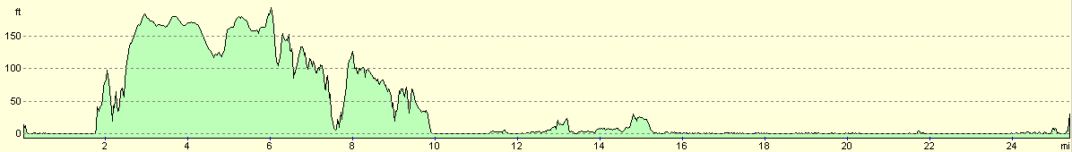
For more information on profiles, ascents and descents, see this page
Accommodation
We spent the night parked at the end of the road that leads to the northern side of the mouth of the River Don. This was not a perfect place to spend the night and lots of people were walking past to gain acces to the beach, but it was good enough for one night.
Disclaimer
Please note that I take no responsibility for anything that may happen when following these directions. If you intend to follow this route, then please use the relevant maps and check the route out before you go out. As always when walking, use common sense and you should be fine.
If you find any information on any of these routes that is inaccurate, or you wish to add anything, then please email me.
All images on this site are © of the author. Any reproduction, retransmissions, or republication of all or part of any document found on this site is expressly prohibited, unless the author has explicitly granted its prior written consent to so reproduce, retransmit, or republish the material. All other rights reserved.
Although this site includes links providing convenient direct access to other Internet sites, I do not endorse, approve, certify or make warranties or representations as to the accuracy of the information on these sites.
And finally, enjoy your walking!
This walk was mentioned in the following routes:
| My walk around the coastline of Britain |
Nearby walks
| # | Title | Walk length (miles) |
|---|---|---|
| 551 | Rattray Head to Cruden Bay | 20.3 |
|
|

|