Walk #553: Bridge of Don to Stonehaven
 |
 |
|
General Data
| Date Walked | 11/09/2003 |
| County | Grampian |
| Start Location | Bridge of Don |
| End Location | Stonehaven |
| Start time | 07.54 |
| End time | 17.01 |
| Distance | 23.6 miles |
| Description | This was not the best walk that I have done recently, but it did have some high points. |
| Pack | Today I carried my 30-litre Karrimor HotRock rucksack, which was filled with my packed lunch, waterproof leggings, water bottle and a couple of spare shirts, together with the usual assortment of odds and ends. |
| Condition | I feel absolutely fine after this walk, and I could easily have walked further if I had needed to. |
| Weather | The day started of sunny, and it was warm enough for me to set off wearing just a sleeveless walking shirt. As the morning wore on, however, it became cloudier, windier and much colder, although I fortunately missed a couple of short showers, only to be caught out by a five-minute one after lunch. |
| OS map | Landranger number 38 (Aberdeen, Inverurie & Pitmedden) and Landranger number 45 (Stonehaven & Banchory) |
 |
 |
|
 |
Map of the walk
Maps courtesy of Google Maps. Route for indicative purposes only, and may have been plotted after the walk. Please let me have comments on what you think of this new format. For a detailed table of timings for this walk, please see the table file.
Notes
I had yet another early start this morning, and this worked out quite well as it allowed me to get a few miles under my belt before breakfast. One I had crossed the River Don the first few miles took me along the promenade southwards to the mouth of the River Dee, and Aberdeen. Along this stretch of beach I saw my first groynes for a long time, and suddenly I felt as though I had been transported back to Blackpool. I was quite looking forward to reaching Aberdeen, as I had never been there before and was interested to see it.
As I have taken over 17,000 photographs on this walk the 40 Gigabyte hard drive in my PC is rapidly running out of space. It had been my intention to archive up some pictures onto CD but as my CD-writer is playing up that is not a practical option. This left me with three choices - get a new CD writer, buy an external DVD drive or get a secondary large hard drive. Normally I have no fears about adding kit to a PC, but I do not have the right screwdrivers to open the case and no mains power for a few days to test any kit I install. For this reason Sam went to PC world in Aberdeen this morning to see how much the options cost. A DVD drive would cost anything from 200 quid, and it would cost 25 pounds for them to fit any kit. This was far too much, so I shall just have to make do for the next few weeks.
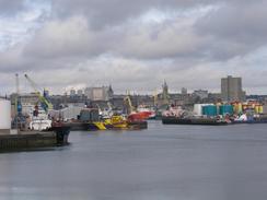
I was quite impressed with Aberdeen, although I did not venture into the city centre. As I walked around the docks it became abundantly clear that just two words could sum up the city - granite and oil. The docks were full of large ships, all related to the oil industry, and unlike many of the trawlers that I have seen on the east coast of Scotland they were all remarkably clean. With hindsight I wish that I had spent some time in the city centre, as it would have been nice to have a look around and examine the buildings. Some of the buildings around the docks area were surprisingly architecturally nice, and I enjoyed studying them as I walked past. Unfortunately as I was walking along the streets I suffered my first cases of 'eye avoidance' for ages - the situation when you pass someone and nod a greeting and they look away. Through the west and north of Scotland people would return my greeting, but obviously Aberdeen is far too much of a city for that to happen.
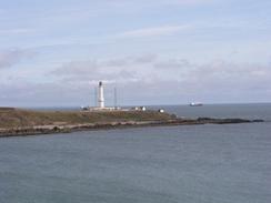
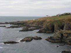
I met Sam near the impressive lighthouse at Girdle Ness, which is of quite an unusual design. I did not spend long in Mervan as I was quite keen to get on, but I also wanted to chat to Sam for a while. From Greg Ness I had intended to walk south along the road beside the railway line, but I discovered a footpath that ran along the top of the cliffs. This was far longer than the road route as it went around every little headland, but it was a far better walk than the alternative along the road. There were several caves that I could see, although I could not get the correct angle to photograph them well. After the beaches of yesterday it was good to be on cliffs, and I enjoyed the walk immensely for that reason as much as any other.
The weather had turned during the course of the morning, and although first thing I was perfectly happy walking in just a short-sleeved shirt the wind picked up and it became much colder by lunchtime. Sam met me for lunch just to the north of Findon, and by the time that I got there my arms were very cold. Sam made me a coffee and some soup to warm me up, and whilst I was in Mervan there was a quick shower that I thankfully managed to miss.
Between Findon and Portlethen I attempted to follow a path that is marked on the map, but once I passed an inspectorate site for lifeboats at Findon House (the yard of the house is filed with many lifeboats from various ships) I could not find a path down into the little valley, so I made my own way down, across the stream and up the other side - easier said than done in my trainers.
The last stretch of the walk was along the A90(T), which at this point is a dual carriageway. As I approached the road from the little village of Muchalls I could see that it was quite busty, and I really did not fancy the walk along it with all the traffic. When I reached it, however, I discovered that there was a surfaced pavement that I could follow southwards. This pavement ended after a while, but a rougher gravel one continued on and the walk was nowhere near as bad as I had expecting it to be.
Today was a bit of a milepost day - under a mile from the end of the walk I finally reached the 6,000 mile mark on the walk. As I walked down the road towards Mervan, which was parked on the promenade, I looked at my GPS and waited for the magic number that meant I had reached the mark to come up, and when it did my mind fluttered over the memories of the walk so far, from Pembrokeshire to Cape Wrath via Southwold, and I could not help tears from rolling down my eyes. Considering I only set out to walk 5,500 miles on this trip having reached 6,000 is a really strange feeling, and I get not a little satisfaction from it.
Directions
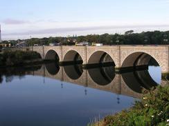
This walk starts off at the end of the road on the northern side of the River Don to the north of Aberdeen. Walk west along the road for a little under half a kilometre to the A956 bridge over the River Don, and then turn left to cross the river. On the southern side turn left down a road that heads eastwards alongside the river towards the sea. When the road cures to the right descend down onto a promenade that heads southwards for a couple of miles passing a leisure centre and funfair on the way. When the promenade ends drop down onto the beach and walk for a couple of hundred yards south towards the breakwater.
Take some steps that lead up through a children's play area and on to a road at the northern mouth of the Dee. From here turn right and pass a control tower of river traffic and follow roads westwards towards the city centre; sometimes you need to divert away from the side of the docks due to restricted areas beside the docks.
When the road meets the A956 dual carriageway turn left for a couple of hundred yards and then left again down another dual carriageway that heads southeastwards. When this ends at a roundabout continue straight on along a road that crosses the River Dee, and on the southern side turn left along another road. This road soon curves to the right and ends at another road; turn left along this road and follow it eastwards alongside the docks and river. It passes the lighthouse at Girdle Ness and descends down towards Nigg Bay. When the road curves to the right turn left up another road that heads south alongside the bay before heading uphill.
At the top of the hill shortly after the road is joined by a railway line turn left along a footpath that heads eastwards along the top of the cliffs to Greg Ness, where the path turns to head in a more southerly direction. The path can now be followed for a couple of miles as it winds around the various inlets and havens on this rocky stretch of cliffs.
A little under a kilometre north of the harbour at Cove Bay the path turns to the right and passes under the railway line to gain access to a track that leads out onto a road in Cove Bay. Turn left along this road and follow it southwards; after a dogleg to the right turn left to head southwards until a bridge over the railway is reached. Here turn right to walk westwards through Cove Bay. After a kilometre turn left down a track, initially lined with trees, that leads past Rigifa Farm and ends at another road.
Turn left down this road and follow it southwards. This road crosses over a railway line and eventually reaches the village of Findon. When the road curves slightly to the right on the northern outskirts of the village continue straight on down a road that drops down slightly until it ends at a T-junction At the junction turn right to another T-junction and turn left down a surfaced track southwards to Findon House. Head through the grounds; the map shows a path heading down into a valley. I could not find this path, so I made my own way down the valley and up the other side.
On the southern side of the valley I followed the cliffs around until I reached a track that led westwards into Portlethen Village. Follow this track through the village and on the western side turn left down a track that heads southwestwards past a farm; at some more farm buildings when the track turns to the right continue straight on along a path that ends in Downies.
Turn right to walk westward through Downies for a couple of hundred yards and then turn left to head south down another track. At times this becomes quite overgrown, but the going is relatively easy as it skirts around Cran Hill and descends down some steps to a stream in Newtonhill. Climb up steps on the other side of the stream and enter Newtonhill. At the top of the steps turn right down a road that led westwards to a bridge over the railway line, and on the other side of the line turn left down a track that headed southwestwards into Muchalls via Mains of Monduff.
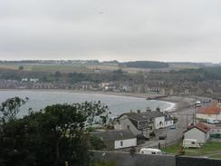
When the track meets the road in Muchalls continue straight on and follow the road as it curves around before ending at the A90(T). Turn left and walk south for a couple of mile along the A90(T), and then turn left down a road that heads southwestwards down towards Cowie. On the outskirts of Cowie turn left down some steps that leads to a road that heads eastwards to the promenade. Turn right and walk south southwestwards for a couple of hundred yards along the promenade to where this walk ends, passing a caravan park on the way.
Distances
| From | To | Distance (m) | Ascent (ft) | Descent (ft) |
|---|---|---|---|---|
| Bridge of Don | Dee Bridge, Aberdeen | 4.8 | 141 | 167 |
| Dee Bridge, Aberdeen | Newtonhill | 13.4 | 1821 | 1634 |
| Newtonhill | Stonehaven | 5.4 | 335 | 522 |
This makes a total distance of 23.6 miles, with 2297 feet of ascent and 2323 feet of descent.
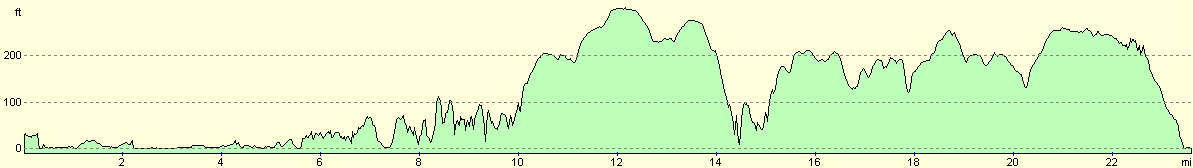
For more information on profiles, ascents and descents, see this page
Accommodation
We spent the night parked on the promenade just to the north of Stonehaven. This was quite near to the municipal caravan site that made me feel slightly cheeky, but we did not need a campsite tonight.
Disclaimer
Please note that I take no responsibility for anything that may happen when following these directions. If you intend to follow this route, then please use the relevant maps and check the route out before you go out. As always when walking, use common sense and you should be fine.
If you find any information on any of these routes that is inaccurate, or you wish to add anything, then please email me.
All images on this site are © of the author. Any reproduction, retransmissions, or republication of all or part of any document found on this site is expressly prohibited, unless the author has explicitly granted its prior written consent to so reproduce, retransmit, or republish the material. All other rights reserved.
Although this site includes links providing convenient direct access to other Internet sites, I do not endorse, approve, certify or make warranties or representations as to the accuracy of the information on these sites.
And finally, enjoy your walking!
This walk was mentioned in the following routes:
| My walk around the coastline of Britain |
Nearby walks
| # | Title | Walk length (miles) |
|---|---|---|
| 552 | Cruden Bay to Bridge of Don | 25.6 |
|
|

|