Walk #554: Stonehaven to Kirkside
 |
 |
|
General Data
| Date Walked | 12/09/2003 |
| County | Grampian |
| Start Location | Stonehaven |
| End Location | Kirkside |
| Start time | 08.30 |
| End time | 16.52 |
| Distance | 22.0 miles |
| Description | This was a far better walk than yesterday's, although it was still hardly a classic walk. It was also quite varied, with beach, path, track and road walking during the day. |
| Pack | Today I carried my 30-litre Karrimor HotRock rucksack, which was filled with my packed lunch, waterproof leggings, water bottle and a couple of spare shirts, together with the usual assortment of odds and ends. |
| Condition | I feel absolutely fine after this walk, and I could easily have walked further if I needed to. I had a couple of twinges from my right foot, and this was annoying because I have not had any for some time. |
| Weather | Today's weather was absolutely superb, with sunshine for most of the day and very few clouds about. The wind had died down from yesterday, and hence it was a lovely day for a walk. |
| OS map | Landranger number 45 (Stonehaven & Banchory) |
 |
 |
|
 |
 |
|
Map of the walk
Maps courtesy of Google Maps. Route for indicative purposes only, and may have been plotted after the walk. Please let me have comments on what you think of this new format. For a detailed table of timings for this walk, please see the table file.
Notes
The sound of the waves cashing against the sea wall at high tide this morning woke me up several times, and consequently when I woke up for good this morning I was quite tired. I really wanted to get an early start to today's walk, but I decided it would be best just to lie down on the sofa in the back of Mervan and have a rest. I still managed to set off before nine, so it was hardly a late start.
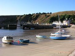
It took me longer than expected to walk along the promenade and footpath to Stonehaven Harbour, which was absolutely lovely. It reminded me very much of a Devon or Cornish harbour rather than a Scottish one, and I walked around it for a short while to explore it in more detail. I then had to find a way to get up onto the road that runs on the cliffs above the harbour, and a local told me the route through the village to reach the path that led to the road.
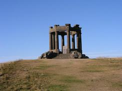
On the hillside above the town is a large and dominant war memorial, which is designed to look uncompleted in memory of all the young uncompleted lives that were lost. I went off the path to have a better look at this, and I walked around it to read the names of the battles engraved on the stonework. I quite like looking at war memorials as I pass them, and I find it quite sobering to read the names of the people who have died. I have seen many different styles of memorial on this trip, but this was one of the more memorable ones.
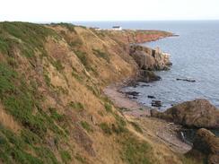
About a mile south of the war memorial were the stunning remains of Dunnottar Castle. This castle is on a peninsular that is almost totally separated from the mainland, and I can imagine that it would have been extremely difficult to attack. I walked around the cliffs that surround it to try and get some decent photographs, but the sun was in the wrong position for all of them and I doubt that I have any nice ones. I was tempted to go and look around the castle, but they recommend two or three hours for a trip and I did not want to spend the money for a flying visit, so I reluctantly decided to move on. When I got back to Mervan I found out that my thoughts about the impregnability of the castle were more or less correct - it withstood the onslaught of Cromwell's army for eight months in 1651 to 1652. They were attempting to capture the Scottish crown; sceptre and sword of state that they thought were hidden in the castle. The regalia were smuggled out of the castle in a fish-wife's basket and hidden in Kindeff Church. Sam and I saw the Scottish crown jewels during a wedding reception at Edinburgh Castle last year, and it was nice to see another part of their history.
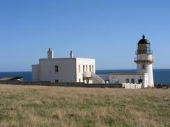
The morning was uneventful until I got to Catterline. I was not sure how I was going to cross the stream that runs past the village, but when I neared the inn I could see a bridge in someone's garden. I went down, only to find that the bridge was at an angle and extremely decrepit. I chatted to the owner before descending down the bank to the side of the stream. There were not enough stones for me use them to cross, and so despite my trainers I just crossed, getting my trainers soaked in the process. This did not bother me too much as my trainers dry out very quickly, but a few yards further on in the field I came across a fairly boggy piece of ground. I managed to cross most of this, but then my left foot sunk in to my ankle and I fell forwards. My right hand went in to above my wrist, and I was left looking as though I was playing a game of twister. I carefully picked myself up so I id not get any more mud on me, and made it across the rest of the boggy ground. I must have looked a real sight I did the best I could to wipe the mud off my right hand on some grass, but was not too successful. I cursed my luck on getting my trainers soaked in mud immediately after soaking them in a stream; if it had happened the other way round I could at least have washed them off! To make matters worse a little further on whilst making my way to the lighthouse at Todhead Point I had to climb uphill through an area of gorse and low conifers, and ended up crawling on my hand and knees through the trees and ended up covered in pine needles!
After all this I decided it would be tempting fate to go cross-country, so I stuck to tracks and roads for the rest of the way to Inverbervie. I must have looked a real sight as I walked down the A92, but I was really beyond caring. Eventually I reached Sam in Inverbervie, and we sat down and chatted for a while whilst I cleaned myself off a little and changed into my boots. The going for the rest of the day was much easier, especially the first four miles when I followed tracks southwards beside an old railway line to Gourdon and Johnshaven, which had a lovely harbour. I chatted to a lady by the harbour who wanted to have streetlights fitted all around it, which I must admit may spoil the nice view somewhat.
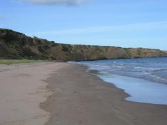
From Johnshaven a path continue on along the coast, initially as a track but then as a path that climbed up and down a cliff face to reach Seagreens and the caravan park at Milton of Mathers. The only real problem section on the rest of the walk was from Milton Ness to St Cyrus, where the path marked on the map was very overgrown and in places eroded away, leaving steep drops down the high cliffs. I would have climbed over the fence and taken an easier route on the field side of the fence, but there was a two-strand barbed wire fence that I could see would be problematic to climb over. Eventually I reached a sloping path that led down onto the beach, and I thankfully took this down onto the northern end of the beach below St Cyrus. I soon made my way to the visitor centre where Sam had parked Mervan, to find a local photographer waiting for me. We had a nice chat and he took some photos, and I then collapsed into Mervan.
Directions
This walk starts off at the northern end of the promenade near a caravan site in Stonhaven. Walk south along the promenade and then follow a boardwalk that heads towards the beautiful little harbour. At the harbour turn right and then left down a road near the police station that soon ends, but becomes a path that heads uphill and ends at a road on the cliffs to the south of the village. At the road turn left and when the road curves sharply to the right take a good surfaced path to the right that leads south past the war memorial. Here it becomes unsurfaced, but is clear enough as it progresses on to the ruins of Dunnottar Castle.
At the castle turn right down a track that leads to a car park near Mains of Dunnottar. Turn left down the road for a couple of hundred yards until it ends at the A92 road. Turn left and walk south down the A92 for a couple of miles, and then turn left down a road that heads south for a mile before ending at a car park in Crawton. Continue on past the car park towards the end of the road, and before you reach a house with a blue railway carriage in it turn right and enter a field. Follow the edge of the cliff southwards past Crawton and Trelong Bay and into Catterline. In Catterline I turned left and headed towards the inn; just past here I turned right towards the stream.
The little footbridge across the stream was decrepit, so I had to ford it and climb up the other bank. From here I headed uphill in a southerly direction towards the house and track at Millhil. Here an ingrown track headed southwards into a stream valley; at the bottom of the stream it became indistinct and I had to scramble uphill through some tree before making my way across a field to the lighthouse at Todhead Point. Here I turned right down a road that led to Halhill.
When the road curved to the right I continued on down a track, and when this ended I continued southwards across fields to the end of another track that leads to the farm at Whistleberry. Continue straight on past the farm, and follow the track as it heads westwards and ends at a T-junction with a road. Turn left down this road and follow it southwestwards until it ends at the A92 turn left and follow this road southwards for about a mile. The road crosses a bridge over Bervie Water and enters Inverbervie; when you reach a church turn left and head downhill to a car park by Bervie Bay.
At the car park turn right and follow a track that heads south alongside the foreshore for about a mile until it reaches a road on the eastern outskirts of Gourdon. Here turn left along a road that follows the shore until the harbour is reached. A track (part of cycle route 1) then heads southwestwards near the old railway line along the shore for a couple of miles, eventually reaching a road in Johnshaven. Continue on along this road towards the harbour and then on along a track to the Narrows. Here the track ends, and a path continues on around some cliffs towards a caravan park at Milton of Mathers and on to Tangleha.
Here turn right up the road and after a couple of hundred yards turn left down a track that ends near a cottage. Here turn right and follow the top of the cliffs westwards; a path descends down into a valley and up the other side where it runs along a narrow band between the fence and the cliff edge. Eventually a cottage is reached to the southeast of Nether Woodston; here a good path descends to meet the northern end of the beach. Walk southwestwards along the beach, and after half a mile turn right and join a track that runs behind the beach past a graveyard and ends at a road by a car park. This walk ends at the St Cyrus National Nature Reserve Visitor Information Centre, which is near to the car park at the road.
Distances
| From | To | Distance (m) | Ascent (ft) | Descent (ft) |
|---|---|---|---|---|
| Stonehaven | Crawton | 5.5 | 554 | 449 |
| Crawton | Inverbervie | 7.2 | 846 | 879 |
| Inverbervie | Johnshaven | 4.3 | 200 | 269 |
| Johnshaven | Kirkside | 5.0 | 463 | 456 |
This makes a total distance of 22.0 miles, with 2063 feet of ascent and 2053 feet of descent.
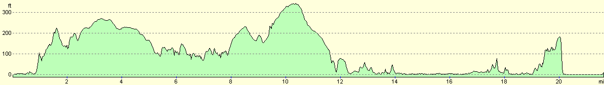
For more information on profiles, ascents and descents, see this page
Accommodation
We spent the night in a little car park right beside the St Cyrus National Nature Reserve Visitor Information Centre, which unlike the nearby car park did not have height barriers. The warden very kindly allowed us to stay here, and it was an ideal spot for us to spend the night.
Disclaimer
Please note that I take no responsibility for anything that may happen when following these directions. If you intend to follow this route, then please use the relevant maps and check the route out before you go out. As always when walking, use common sense and you should be fine.
If you find any information on any of these routes that is inaccurate, or you wish to add anything, then please email me.
All images on this site are © of the author. Any reproduction, retransmissions, or republication of all or part of any document found on this site is expressly prohibited, unless the author has explicitly granted its prior written consent to so reproduce, retransmit, or republish the material. All other rights reserved.
Although this site includes links providing convenient direct access to other Internet sites, I do not endorse, approve, certify or make warranties or representations as to the accuracy of the information on these sites.
And finally, enjoy your walking!
This walk was mentioned in the following routes:
| My walk around the coastline of Britain |
Nearby walks
| # | Title | Walk length (miles) |
|---|---|---|
| 553 | Bridge of Don to Stonehaven | 23.6 |
| 555 | Kirkside to Seaton House | 22.1 |
|
|

|