Walk #555: Kirkside to Seaton House
 |
 |
|
General Data
| Date Walked | 13/09/2003 |
| County | Grampian, Tayside |
| Start Location | Kirkside |
| End Location | Seaton House |
| Start time | 09.15 |
| End time | 17.38 |
| Distance | 22.1 |
| Description | This was quite a nice, varied walk, although the weather made it slightly annoying. |
| Pack | Today I carried my 30-litre Karrimor HotRock rucksack, which was filled with my packed lunch, waterproof leggings, water bottle and a couple of spare shirts, together with the usual assortment of odds and ends. |
| Condition | The biggest problem that I had today was with one of the toes on my left foot, which hurt as soon as I changed into my trainers after lunch. This continued but did not really worsen throughout the rest of the afternoon, and I think that it may be because the nail is too long. |
| Weather | It rained overnight, but fortunately by the time I set off this morning it had stopped and been replaced with a mixture of sunshine and cloud, the clouds predominating over the sun. There was quite a fierce southerly wind, and this was annoying as I was heading south and so it was a headwind. All in all it could have been worse, but it could also have been much better. |
| OS map | Landranger number 45 (Stonehaven & Banchory) and Landranger number 54 (Dundee & Montrose, Forfar & Arbroath) |
 |
 |
|
 |
 |
|
Map of the walk
Maps courtesy of Google Maps. Route for indicative purposes only, and may have been plotted after the walk. Please let me have comments on what you think of this new format. For a detailed table of timings for this walk, please see the table file.
 |
Notes
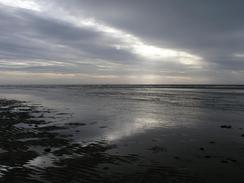
I did not want to set off too early today, as I had been told that it is possible to ford the River North Esk, which splits the beach behind Montrose Bay into two, at low tide. Low tide was due for about nine, and so that was the time I got myself ready to set off for. By the time that I reached the River North Esk there were wide expanses of sand on the beach, and I easily got over a small tributary only to be faced by the main channel. Not wanting to prevaricate and knowing that I would get wet whatever I did, I just strode into the water. At the deepest it came just over my knees, and the current was not too swift so it did not upset my balance on the sandy bottom. I soon got over to the other side and jut continued southwards along the beach, my boots squelching as I went.
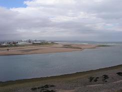
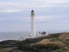
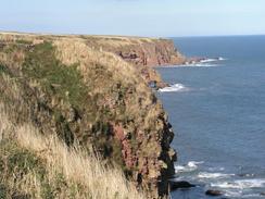
Sam was waiting for me near the bridge over the river in Montrose, and I went in for a bite of breakfast. Sam and I had an idea of future plans last night, and she had been doing some preliminary investigation to it and we chatted about these for a while before I set off once again. The walk to the attractive lighthouse at Scurdie Ness was straightforward, and after this I followed the edge of the low cliffs to Usan and onwards to Lunan Bay, where I met Sam for a late lunch.
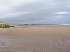
On Lunan Bay I had to cross Lunan Water, and as my trainer were filthy after yesterday's walk I decided to wear them to see if I could clean them as I crossed the river. It was nowhere near as deep as the North Esk was this morning and the water was surprisingly warm, and so I walked up and down to try and get the worst of the mud off my boots. This worked quite well, although I was squelching along for most of the rest of the afternoon.
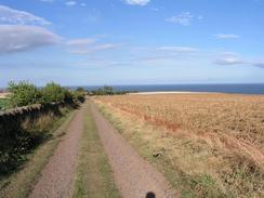
The rest of the walk was along a series of tracks and roads that took me past the pretty little village of Auchmithie and onwards towards the campsite at Seaton House, where Sam was waiting for me. This stretch of the walk was fairly boring and away from the cliffs, so I just listened to the radio and plodded on regardless.
I was quite relieved when I reached the farm at East Seaton, as by this stage a toe on my left foot had gone beyond the aching stage and was definitely hurting. The whole area around the farm is one big growing area, with many plastic greenhouses with plants growing in them. Once I had negotiated these I could see static caravans at the large caravan site where we were spending he night, but they were over a high wall guarded with barbed wire and broken glass set in the top. I had no choice but to walk around as the entrance came in from the north and I was on the south. I could see the caravan park as I walked past another growing area, but two high barbed wire fences guarded the park, and in one place three. I was annoyed as I could see Mervan waiting for me, but fortunately a few hundred yards further on I found a place that I could squeeze between the fences and a wall to make my way over and into the caravan park.
As I was waiting for a script to run tonight I put teletext on, and I was shocked to see that an eleven year old girl had died falling down the cliffs at Needle E'e, which is about a mile away from the campsite where we are now. It is a terrible tragedy, and reminds me of the risks of walking at the top of cliffs, and that I have been lucky getting away with some of the silly places that I have walked on this trip. There but for the grace of god...
It is strange to think that I only have a fortnight left before I finish the trip at Edinburgh Castle. For the vast majority of the trip Edinburgh has seemed so far away as to be unthinkable, and now it is so near. In a way I find the mere thought of finishing the walk to be quite depressing, and therefore I am trying to concentrate on other matters. Part of me is tempted to extend the trip by walking southwards from Edinburgh, but my body is starting to tire now and I could do with a rest, so although it is tempting it is unrealistic (and besides, Sam would kill me!). I am now well over 6,000 miles into the trip, and with well under 300 miles left to go in two weeks it is literally a drop in the ocean when compared to what I have already done. But I am wary nonetheless; it would be a disaster to have got this far and to have something go wrong at this late stage.
Directions
This walk starts off at the St Cyrus National Nature Reserve Visitor Information Centre in Kirkside, to the southwest of St Cyrus. Leave the visitors centre and turn right to walk northwestwards for a few yards, and then turn right to walk along a bridge and a boardwalk to the sand dunes. Climb over the sand dunes and onto the beach below. Note that the following route is only available of the tide is out. Once on the beach turn right and follow it southwestwards towards the mouth of the River North Esk. If the tide is out then it is fairly easy to cross the mouth of the river to gain access to the southern side of he river. Once on the other side head south along the beach down Montrose Bay towards Montrose. Once the road starts on an embankment to the right climb up onto this and follow it as it swings around to the right past a caravan park. Immediately before the road climbs up over an old railway bridge turn left down another road that heads past a chemical plant before ending at the ludicrously short B9100 road. Turn left down this road and then turn right down another road that leads up to the B9133 road.
At the B9133 road turn left and follow it westwards for a few hundred yards until it ends at the A92 road. Turn left and follow the A92 as it crossed the River North Esk at the mouth of the Montrose Basin and continues on to a roundabout. At the roundabout turn left and follow another road eastwards through Ferryden, passing a church. When the road heads to the right uphill near the pub continue straight on along a road above the river for a few yards, before turning right up another road that turns to the parallel the road before heading to the lighthouse at Scurdie Ness. Round the lighthouse and then follow the tops of the low cliffs southwards past Mains of Usan and on to Usan. At Usan climb onto the top of the cliffs, which become higher here, and follow the tops of them along to an old, disused, cemetery. Here turn right and follow a track northwestwards, which passes under a railway line before ending at a road. Turn left along this road and follow it westwards towards Dunninald Mains, and then turn left down another road that heads westwards for about a kilometre until it reaches a crossroads.
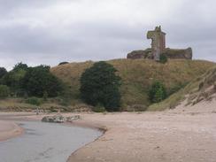
Once at the crossroads turn left and follow a road southwards. After a mile it crosses the railway line on a bridge, and a few hundred yards afterwards at the bottom of the hill turn left along a track that leads to a car park in Lunan. Cross the car park and head over the sand dunes to gain access to the beach. Once on the beach turn right and follow it southwards; it was easy to cross the mouth of Lunan Water under Red Castle. Continue south for a couple of miles along the beach until it ends, and then take a path that heads behind some chalets and goes east along the top of the cliffs towards Ethie Haven; just before the descent to the hamlet is reached turn right down a track that heads southwestwards towards North Mains. At North Mains join the road and follow it southwestwards for under a kilometre until it ends at a T-junction with another road; turn left down this road and follow it southeastwards to Ethie Barns and then West Mains. At West Mains the track turns to the right and it can be followed southwestwards for a couple of kilometres before a track leads off to the left that heads down to the eastern end of Auchmithie.
At Auchmithie turn right and follow the road southwestwards through the village; when the road curves to the right on the western side of the village continue straight on down a track that heads southwestwards towards Windyhills. Here turn left down another track for a few yards and then turn right down another one that heads southwestwards to a wooded valley called Seaton Den. Several paths lead steeply down into the bottom of this valley, where a little footbridge leads over the small stream and a path leads steeply up the other side. At the top join a track that heads southwestwards across a field to East Seaton Farm; at the farm skirt to the right of the buildings and join a track that passes the buildings before reaching a crossroads, with a public road continuing straight on. Turn right and walk northwestwards up a track that has a tall wall to the left until a gate is reached on the left; this leads into the East Seaton Caravan Park, where this walk ends.
Distances
| From | To | Distance (m) | Ascent (ft) | Descent (ft) |
|---|---|---|---|---|
| St Cyrus National Nature Reserve Visitor Centre | River bridge in Montrose | 5.1 | 39 | 46 |
| River bridge in Montrose | Lunan | 8.1 | 771 | 764 |
| Lunan | Auchmithie | 5.9 | 407 | 295 |
| Auchmithie | Seaton House | 3.0 | 190 | 121 |
This makes a total distance of 22.1 miles, with 1407 feet of ascent and 1226 feet of descent.
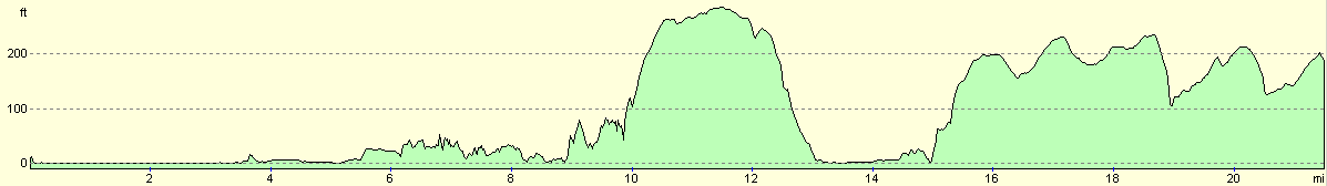
For more information on profiles, ascents and descents, see this page
Accommodation
We spent the night at the Seaton Estate Caravan Site, Seaton House, Arbroath DD11 5SE, telephone (01241) 874762 or email seatoncaravans@btinternet.com. This site was quite nice and set in some lovely wooden garden with several items of interest to see, but it was rather expensive at fourteen pounds for the night, which is more than we normally like to pay.
Disclaimer
Please note that I take no responsibility for anything that may happen when following these directions. If you intend to follow this route, then please use the relevant maps and check the route out before you go out. As always when walking, use common sense and you should be fine.
If you find any information on any of these routes that is inaccurate, or you wish to add anything, then please email me.
All images on this site are © of the author. Any reproduction, retransmissions, or republication of all or part of any document found on this site is expressly prohibited, unless the author has explicitly granted its prior written consent to so reproduce, retransmit, or republish the material. All other rights reserved.
Although this site includes links providing convenient direct access to other Internet sites, I do not endorse, approve, certify or make warranties or representations as to the accuracy of the information on these sites.
And finally, enjoy your walking!
This walk was mentioned in the following routes:
| My walk around the coastline of Britain |
Nearby walks
| # | Title | Walk length (miles) |
|---|---|---|
| 554 | Stonehaven to Kirkside | 22.0 |
| 556 | Seaton House to Broughty Ferry | 17.6 |
|
|

|