Walk #126: Farrington Gurney to Bath
 |
 |
|
General Data
| Date Walked | 27/11/2000 |
| County | Avon |
| Start Location | Farrington Gurney |
| End Location | Bath YHA |
| Start time | 09.22 |
| End time | 14.40 |
| Distance | 12.6 miles |
| Description | This was a pleasant walk north-eastwards into Bath, with a combination of road and path walking. |
| Pack | Today I carried a large pack with no tent. |
| Condition | I am fatigued, but generally okay. I have no new blisters, and my ankle has not given me any trouble. Unfortunately my feet again ached during the walk, and although the pain was not enough to cause me to cut short the walk, it was bad enough to cause me a great deal of discomfort. My right shoulder aches a little, and is red-sore in a band across the top beside me neck. It does not hurt as bad as it looks, however. |
| Weather | Another day of occasional showers and high winds, although the overall temperature was higher today than it was for the previous couple of days. When I set off it was raining fairly hard, although this soon became a drizzle and, later on, it stopped. It never really looked like being dry enough for a long enough period for me to be able to take my coat off. |
| OS map | Landranger number 172 (Bristol & Bath, Thornbury & Chew Magna) |
 |
 |
|
Map of the walk
Maps courtesy of Google Maps. Route for indicative purposes only, and may have been plotted after the walk. Please let me have comments on what you think of this new format. For a detailed table of timings for this walk, please see the table file.
Notes
Today was a very exhilarating day, because when I reached Bath YHA, halfway up Bathwick Hill from the centre of Bath, I had completed the entire walk from Land's End to Crieff in Scotland, a walk of over 1150 miles in length. The feeling of exhilaration was superb, and the anticipation of the Scottish sections to come - hard as they undoubtedly will be - was also keenly felt.
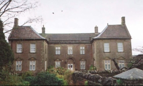
I delayed my start from the excellent B&B in Farrington Gurney for two reasons - firstly it was raining hard, and secondly I was having a very nice conversation with the landlady, er son and one of the guests. This really has been one of the best B&B's that I have every stayed in, and I was made to feel most welcome.
Since the weather was still highly non-optimal, and because of all the mud that I had encountered over the last couple of days, I decided to road-walk where possible today instead of following the paths along Cam Brook which promised to be very muddy. However I still did a fair amount of path walking where it was appropriate, so I ended up getting muddy anyway.
I tried to force myself to keep up a fast pace because today was the last day in a three-day trip and I wanted to start the long drive back to Cambridge as soon as possible. Unfortunately I still took over five hours to walk an approximately twelve mile walk - which was not as fast as I should have been going. The main reason for my relatively slow pace was my feet, which were aching as they had for the previous two days. There is something about my Salomon X-Adventure 7's that cause me discomfort, particularly if I do a lot of road walking. After about eight miles the underside of my feet are in agony. It is a shame, because in other ways they are brilliant boots. I have some Sorborathane inserts in them, so I may try a different sort to see if can prevent my feet from over-pronating.
There are some very nice and picturesque villages on this route, and in particular Southstoke, just to the south of Bath, was very nice. The buildings in the village were all made out of Cotswold Stone, and it literally glistened in the rain.
I seem to be in the habit of attracting people who in all honesty could probably be best described as nutters. When I was walking across fields near the Cam Brook in Carlingcott I got slightly lost (the 1 to 50,000 map did not accurately show the route of the path on the ground). I crossed the river correctly by a footbridge next to the Mill, but instead of following the muddy path uphill and through a gate, I turned right and walked along the brook's floodplain, which had obviously recently been flooded. I was unsure of the route, so I picked my way carefully along. I had only gone about 50 yards when a man came out of a bungalow on the other side of the stream and started shouting at me. He mentioned something about my setting off all his alarms, and microwave alarm systems that would kill me if I walked any further. I apologised profusely by shouting across the brook, and made my way back to the path in the direction he pointed.
About five minutes later I was chatting to a lady and gentleman further along the path. They mentioned that they were local, so I told them about the incident with the man. Apparently they own the field that I was walking through at the time, and the man who lived in the bungalow opposite had recently spent a fortune on burglar alarms after having a lawnmower stolen. They laughed at my story, and apologised for him. They also mentioned that he was a bit weird, an opinion that I must say that I wholeheartedly agree with.
I got slightly lost in the Camerton area when I entered a local nature reserve with paths going through it instead of the correct path that passed to the north of the reserve. I ended up climbing up what must have been a wooded spoil heap, only to find that after having descended it again there was no exit at the eastern end of the reserve. This meant that I had to return back to the entrance to the park at the road and find the proper route.
Directions
These directions outline the route that I took when I did this walk; it involves some unnecessary road walking and it should be easy to create your own route which follows paths for nearly the whole distance. In particular the Limestone Link footpath follows the Cam Brook from the village of Hallatrow (about a mile north of Farrington Gurney) to just south of Southstoke. This route would have been fairly muddy on the day that I was in the area, however.
Leave the Main Street in Farrington Gurney and turn right. Head through the village to the church. Just before the church a path leaves the drive and heads in a south-northeasterly direction over some rough fields until it meets a minor road.
Join the road and turn left down it for about three-quarters of a mile into the village of Paulton. When the road ends turn right down the B3355 past Paulton Church, and then almost immediately left up another road that leads uphill. Continue on this road as it passes Withy Mills for about one and a half miles into the little hamlet of Radford.
In Radford cross over a little stream (the Cam Brook, which we will be following for the next few miles as far as Dunkerton). Take the second road on the right (the first after the stream), that heads eastwards for half a mile into Camerton. Before you reach the village you can turn left and then right to join the old railway line and follow that for a short distance past a building site (which will soon be some shiny new homes) into Camerton.
In Camerton do not enter the nature reserve (which has a metal statue of a miner standing guard over it), but join the winding road that heads roughly eastwards past Wick Lane and into Camerton. Just before Camerton the road bends to the right and heads sharply uphill. Just after the bend a little lane heads off to the left to the Mill. Follow this road and just before the Mill is reached turn left and pass over Cam Brook via a footbridge. When in the fields on the other side head slightly uphill off the floodplain and through a gate into the next field, and then turn right to join a road.
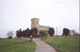
From here the map is slightly confusing, but turn right down the road and before a bridge over the brook turn left and follow a footpath on the northern side of the Brook. When I walked this stretch the path was flooded and very nearly part of the Brook itself, which made going slightly difficult. After a short distance the Brook is crossed by a footbridge, and the southern bank is followed on higher and firmer ground until a road is reached. Turn left down this road and follow it as it follows the northern bank of the Cam Brook as far as the church in Dunkerton. Continue past the church until you reach the A367 main road.
Turn left uphill along the A367 for a very short distance and then cross the road and follow a track that heads to the east uphill before turning to a north-northeasterly direction steeply uphill. This is a section of the Fosse Way Roman road, and we follow it for about a mile until it meets the A367 road again, crossing one minor road on the way.
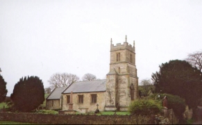
At the A367 turn right for a short distance and then take a footpath to the right that skirts along the side of a hill and through a small piece of woodland to a road. Cross the road and take another footpath on the other side that heads to the east before joining an unpaved track to the south of Sulis Manor and heading past a farm into the very attractive Southstoke.
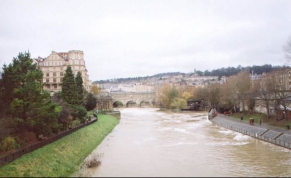
Head past the church in Southstoke and take a minor road that heads uphill to the north. This soon brings you out onto the B3110, which is crossed and then head downhill to the A3062. Cross this as well, and hen head along this road as it descends into the centre of Bath. About a mile from the A3062 junction the road bends to the north-east to the south of some schools and eventually comes out just before the railway station on a main road. Cross this road and cross the River by a footbridge. This then brings you out at the rear of the railway station.
Head under the railway and emerge at the front of the railway station. Cross a road and head straight on down Manvers Road, past the bus station on the left and the police station on the right. The next road to the right (North Parade Road) leads over a bridge over the river and, just past the North Parade cricket ground, a T-junction with Pulteney Road under a railway bridge.
In the brick abutments to the railway bridge on the other side of the road is a gap, through which a path leads past a school and up to the Kennet and Avon Canal. Turn right along this canal for a short distance to a lock with a footbridge going over it. Cross the bridge, and follow path uphill. This path crosses Sydney Buildings Road and then heads quite steeply up the hill, before bringing you out on Bathwick Hill Road just below the Youth Hostel.
Distances
| From | To | Distance (m) | Ascent (ft) | Descent (ft) |
|---|---|---|---|---|
| Farrington Gurney | Dunkerton church | 6.1 | 371 | 581 |
| Dunkerton church | Bath railway station | 5.4 | 709 | 830 |
| Bath railway station | Bath YHA | 1.1 | 312 | 16 |
This makes a total distance of 12.6 miles, with 1392 feet of ascent and 1427 feet of descent.
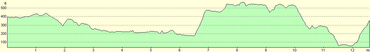
For more information on profiles, ascents and descents, see this page
Accommodation and transport
Bath has excellent rail links to the west country and London, and also has very good road links (the M4 being a few miles to the north). Accommodation is also plentiful, with many hotels and B&B's being available. There is a YHA on Bathwick Hill, and an independent backpacker's hostel just up the road from the bus and railway stations.
Disclaimer
Please note that I take no responsibility for anything that may happen when following these directions. If you intend to follow this route, then please use the relevant maps and check the route out before you go out. As always when walking, use common sense and you should be fine.
If you find any information on any of these routes that is inaccurate, or you wish to add anything, then please email me.
All images on this site are © of the author. Any reproduction, retransmissions, or republication of all or part of any document found on this site is expressly prohibited, unless the author has explicitly granted its prior written consent to so reproduce, retransmit, or republish the material. All other rights reserved.
Although this site includes links providing convenient direct access to other Internet sites, I do not endorse, approve, certify or make warranties or representations as to the accuracy of the information on these sites.
And finally, enjoy your walking!
This walk was mentioned in the following routes:
| My sectional Land's End to John O'Groats walk |
Nearby walks
| # | Title | Walk length (miles) |
|---|---|---|
| 72 | Bath to Devizes | 19.3 |
| 125 | Cheddar to Farrington Gurney | 13.7 |
| 616 | Cotswold Way: Bath to Tormarton | 18.2 |
|
|

|