Walk #714: A circular walk from Helmsey to Rievaulx Moor
 |
 |
|
General Data
| Date Walked | 18/02/2006 |
| County | North Yorkshire |
| Start Location | Helmsley |
| End Location | Helmsley |
| Start time | 09.30 |
| End time | 16.40 |
| Distance | 20.2 miles |
| Description | This was a varied and pleasant walk on the very southern outskirts of the North Yorkshire Moors National Park. |
| Pack | Today I carried my 30-litre Karrimor rucksack filled with my waterproofs, two litres of water, a book and various other odds and ends. |
| Condition | I feel absolutely fine after this walk, and am pleased to say that, for the first time in six months, my knees gave me absolutely no problems, despite the steep climbs and descents that occurred during the walk. |
| Weather | The day was mainly sunny and quite mild for the time of year, with only a few clouds in the sky to hide the sun occasionally. This made it a very enjoyable day for a walk, especially as there was little wind to chill me. |
| OS map | Landranger number 100 (Malton & Pickering, Helmsley & Easingwold) |
 |
 |
|
 |
 |
|
Map of the walk
Maps courtesy of Google Maps. Route for indicative purposes only, and may have been plotted after the walk. Please let me have comments on what you think of this new format. For a detailed table of timings for this walk, please see the table file.
 |
 |
|
 |
 |
|
Notes
The North Yorkshire Moors are one of the few large scenic areas that I have not really done any walks in - although I have done the coastal section of the moors as part of my coastal walk, I have yet to walk in the classic moorland terrain in the centre. For this reason I chose late on this week to take a three-day holiday that I had booked to go walking in the moors, after deciding on, and rejecting, finishing the South Downs Way and doing a few county tops in South Wales. Those two options proved to be non-starters, and after booking a B&B for two nights in the heart of the moors via a round-robin of B&Bs, I set off at six on the long drive. The AA website told me that it would take four hours to get up to Helmsley, but in the end it only took me three and a quarter, including two stops on the way.
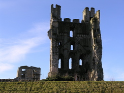
My first sight on entering Helmsley on the main road was of the castle ruins, spectacular, with half of the Keep standing proud in the blue sky. It was easy to find the long-stay car park in the beautiful village, and after paying the rather steep £4.50 for a day's stay, I got my kit together and locked my car. Instead of heading straight out to the path I decided to take the path that led past the visitor centre towards the castle; there were some good views over the ruins from the path once the wall to the right stopped, but I could not enter the castle grounds as the entrance was in the closed visitor centre. The path diverted away from the castle and into the centre of the village, and I walked back round to the car park and a stone seat marking the start of the Cleveland Way. As I passed the seat I realised that I had left my phone on charge in the car, so I walked the short distance retrieved it and headed back to the path.
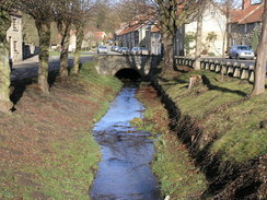
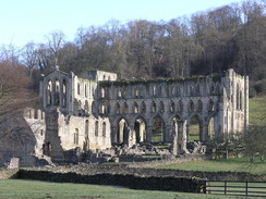
Initially the Cleveland Way was quite muddy, and I slipped and slided as I walked along the wide path westwards. It climbed slowly uphill with some good views back over towards the castle, and these only ceased when the path jinked to the left and then right before going through an area of woodland. The path became a track as it slowly descended, with a thick bed of brown leaves crunching underfoot as I strolled, braking myself with my knees as I headed down towards the road. This was soon joined, and no cars passed me as I walked westwards towards the bridge over the River Rye. It had been my intention to walk over the bridge and head north through Ashberry Wood, but just before the bridge was reached I got a glimpse of the magnificent Rievaulx Abbey off to my right. This instantly caused me to change my mind, and instead of crossing the bridge I took the road that headed north towards the abbey, which increasingly grew in size and magnificence as I slowly approached it.
The skies were blue overhead as I looked as the abbey from near the visitor centre, the empty arches of the Nave looking spectacular and a strange massive stone wall in the foreground. It was tempting to go into the visitor centre and have a look around, but there were still many miles to walk and so, with reluctance, I pressed on along the road, which headed uphill before a track led off to the left. This ascended some more before dropping down to cross the River Rye once more by a nice stone bridge. On the other side a track climbed up, with the views obscured by trees for much of the time. The track underfoot was good, however, and allowed me to make good time to Tylas Farm. Here there were many people on horses and vehicles, some of the red-coated figures drinking from large glasses. I assumed that I had come across a hunt, a year to the day after fox hunting was banned, but later I discovered that there was a point-to-point in the area, and so I assume that they were to do with that, Whatever they were there for the horses looked magnificent, and as I headed on via a steep-sided valley to Barnclose Farm I kept making backwards glances towards the farm and the crowd of people and vehicles.
From Barnclose Farm a rather undistinguished footpath contoured me along the side of the valley, before descending past a farm to reach a road and then Shaken Bridge over the River Rye. As I approached the bridge I was surprised to see a bailey bridge controlled by traffic lights, and as I started onto the adjacent pedestrian footbridge a car overtook a stationary car at the light and, unsighted across the bridge, jumped the lights and shot across the bridge in a crazy manner. He got away with the manoeuvre, and a few moments later I saw the reason why the bailey bridge was in place - Shaken Bridge had obviously lived up to its name, and the downstream half had fallen down. The remaining upstream part of the bridge faced the bailey bridge, and underneath the magnificent arch there were red steel beams holding up the remains of the structure. It left me wondering how the downstream part of the bridge had collapsed (I would have expected the upstream side to have suffered in a swollen river), and whether the bridge was going to be repaired. Looking at the beams holding the remains up I assumed that they would, which would be nice as the bridge is such a pleasing structure.
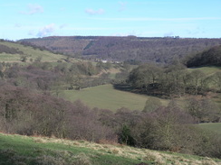
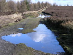
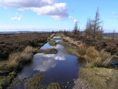
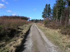
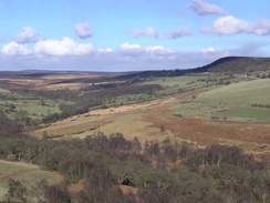
A steep climb followed as the path headed uphill along forestry tracks, zigzagging as it made its way up the hillside. This was a bit energetic and I was breathing hard, but I did not stop until the gradient flattened and the track became wider amongst the trees. Fairly soon afterwards a main road was reached, and although this was not too busy I carefully walked along it until a little lay-by was reached on the left, from where there were some superb views westwards over the moors. Here I left the road, and joined a footpath that followed a track, initially through trees, before opening out onto Rievaulx Moor. I felt elated to finally be on moorland after such a long approach walk, and as I enjoyed the contrast of the blue sky against the browns of the out-of-season heather from the wide white scar of the track.
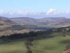
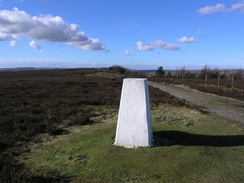
The path curved from a northeasterly to an easterly course, and there were some superb views to be had over the moors to the north. In the distance there were three patches of smoke rising up from the moors in various places, and I assume that this is from people burning off patches of heather, something that is sometimes done in winter as Grouse prefer younger shoots of heather rather than the older, tougher heather. The track rose slowly and the ascent was not troubling, and eventually the trig pillar came into view, the bright white paint glaring in the bright sunshine. There was little wind and it seemed like a good place to stop, so I took my rucksack off and sat down with my back to it, looking out over the moors to the north. It was a superb place to have a rest, and the bright sunshine and views made me think that this was the best walk that I had done so far this year, better than patches of the South Downs due to the presence of the bleak but wonderful moorland.
I did not spend too long at the pillar, and soon got up and started heading along the track towards a little dead-end local road near Roppa Wood. I crossed this and continued on the other side along a track that headed through some trees, slowly descending as it did so. It was a good walk, and the fact that some of the trees alongside the track had been cleared meant that the walk was less claustrophobic than it would have been. The walk did get a little boring, however, as the views were foreshortened by the trees, and I was relieved when a car park was reached, shortly followed by the road at Cowhouse Bank. I turned to the left and started following this road as it headed steeply downhill, my legs constantly having to brake myself from jogging downhill. The road was quiet and only one car passed me as I headed downhill, and once the gradient slackened a track led off to the right. This was a short but pleasant walk down to a stream at the bottom of Riccall Dale, which was followed by a steep climb up a track towards Howl Wood Farm, passing some lovely small rock outcrops on the way.
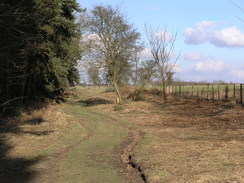
At Howl Wood Farm an initially muddy track took me onwards towards Hasty Bank Farm, and as this entered a field an entire flock of sheep started following me. One of these was limping, and as it came closer I realised that it only had three legs, one of its back legs being missing. It seemed to be able to keep up as much speed as the other sheep, and whenever I stopped the sheep would continue nearer me and then stop, only resuming once I started walking once again. I soon exited this field leaving the sheep locked safely behind the gate, and neared the farm. The track did not enter the farm but started a lung-busting climb uphill along a tree-lined track, and it was with relief that I reached the top and joined a footpath that headed southwards along the edge of some woodland. In places the footpath was quite narrow as it headed through the trees, but this did not slow my progress too much and I made good time along what was a fairly uninteresting stretch of footpath, and views being obliterated by the trees.
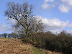
Eventually the footpath emerged from the trees and continued a little away from their edge, ending at the end of a muddy track. I followed this to a road, which I then followed southwards to the A170 road. Here I was left with a choice; I could walk further south towards Harome and head to Helmsley from there, extending the walk by four or five miles. There was still enough daylight to do this, but I decided that I would prefer to find my B&B in the daylight, so I started walking along the A170 towards Helmsley instead. There was no pavement and the road was busy, so shortly after crossing the River Riccall I decided to get off the road by using a bridleway that headed back northwards. This was a pleasant walk and soon left the green floodplain to become a tree-lined track. I was looking for a footpath that headed up the bank to the left, and I ignore one that was too early and instead walked on along the track for another couple of hundred yards. It became obvious that I had walked too far, so I headed back and took the footpath that led up through the trees before opening out into a field.
The path passed Reagarth Farm and started descending down towards Helmsley, entering the village near the youth hostel. As I was still feeling fit I decided to extend the walk slightly, and crossed the A170 to take a little looping walk through the village before heading back towards the centre of the village. Whereas it had been quiet in the morning it was bustling this afternoon with police out directing traffic; the horse boxes suggesting that the traffic streaming down one road was something to do with the point to point meeting. The town looked even more superb in the afternoon sunshine, and I walked slowly back to the car, enjoying looking at the buildings.
Whereas mine had been the only car in the car park this morning it was now nearly full, and it did not take me long to get my gaiters and boots off and head off, stopping off on the way to get some cash in the centre of the village. An exhilarating drive followed via Hutton-le-Hole to Rosdeale Moor, and then a steep descent down a road into the village. I found the B&B just as it was starting to get dark, and they made me feel very welcome, with two cups of tea before I went upstairs to have - joy of joys - a piping hot bath, instead of the usual B&B showers. Later on I drove back into the village for a meal at the Coach House Inn, which had cheap drinks as it was closing that evening for refurbishment. The place was heaving with a wedding party in, and although I could not have any alcohol as I was driving I let the atmosphere soak into me as I ate, looking back on a wonderful day's walk.
 |
 |
|
Directions
This walk starts off at the long-stay car park in Helmsley, which is situated near to the castle. Leave the car park by the entrance road, and where it meets the public road there is a seat on the left marking the start of the Cleveland Way. Turn left by the seat and start following a bridleway westwards, which slowly climbs uphill giving some good views back towards the castle. When the track ends a footpath heads off to the left for a short distance, heading downhill towards some woodland before turning to the right. The path descends down some steps into Blackdale Howl, before steeply climbing up the other side, to continue on towards a lodge on the right. The path heads west along the top of Whinny Bank, before curving to the right to head northeastwards downhill through Quarry Bank Wood.
The path ends at a road; turn left and follow this road as it heads westwards for a few hundred metres until it reaches Rievaulx Bridge over the River Rye. Do not cross this bridge, but instead turn right and follow a road northwards along the eastern bank of the river, heading towards the ruins of Rievaulx Abbey. The road passes the ruins and then turns to the right to head uphill; when the church is reached on the right a track leads off to the left. Turn left and follow this path as it heads uphill to the west, passing a house on the left and taking a northwesterly course uphill. When the track forks turn left along a track that starts heading downhill to reach another bridge over the River Rye. Cross this bridge, and on the other side a track curves to the right to head uphill to the northwest, skirting the hillside to reach Tylas Farm.
The track descends down past Tylas Farm and then climbs uphill to reach Barnclose Farm; here the track ends and a footpath heads on, contouring the hillside and passing directly under a patch of woodland before reaching a track. Join this track and turn right to start heading down towards Shaken Bridge Farm; the path leaves the track for a short period to bypass the farm and rejoins it on the other side, before soon ending at a road. Turn right along this road and head for a short distance to Shaken Bridge over the River Rye. Cross the bridge and on the other side turn left along a track that heads through a patch of woodland to approach some buildings at Broadway Foot. Just before the buildings are reached turn right along another track, and after a hundred yards turn left along another track that soon curves to the right as it climbs steeply though some woodland before ending at the B1257 road.
Turn left and walk northwestwards along the B1257 road for a couple of hundred yards until a lay-by is reached on the left at the top of Newgate Bank. Here turn right and start following a bridleway that heads northeastwards through some woodland, before emerging out onto the edge of Rievaulx Moor. A track continues on, skirting the northern edge of the moor and curving to take a more easterly course as it passes a trig pillar and reaches a road. Cross this road, and on the other side another track leads on, heading through Baxton's Wood and heading southeastwards before ending at a car park by a road at the top of Baxton's Wood.
Turn left and follow the road as it heads steeply downhill; near the bottom a crossroads with a track is reached turn right and follow this new track as it heads downhill to the southeast; after a couple of hundred yards a track leads off to the left; follow this track as it descends to cross the River Riccall on a bridge before climbing uphill along a track to reach Howl Wood Farm. The track skirts the farm buildings and goes through a gate, entering a muddy field and contouring around the hillside, soon curving to head southeastwards towards Hasty Bank Farm. The track crosses a stream and reaches a junction just before the farm; here turn let and start following a track that leads steeply uphill through some woodland.
When the track emerges out from the woodland turn right to join a footpath that heads south, skirting the edge of the woodland. The path is relatively flat as it winds through the trees; it leaves these for a while but rejoins them, and after about two miles the end of a track is reached. Turn left and follow this track as it heads eastwards to end at a road in Pockley. Turn right and follow this road as it heads southwards for a little under a mile until it ends at the A170 road; here turn right and carefully follow the A170 westwards for a few hundred yards until the bridge over the River Riccall is reached. Cross the bridge and once on the other side turn right to join a footpath that follows a track northwards along the western side of the river. After a few hundred yards a crossing with another footpath is reached; turn left and follow this path as it heads steeply uphill through the trees.
Once the path emerges from the trees into a field it continues on westwards, passing Reagarth Farm before heading downhill and curving to the left to angle towards Helmsley. As the path approaches the A170 it turns to the right slightly to parallel it westwards before ending at a road near the youth hostel in the village. Turn left along this road for a few yards before ending at the A170; the centre of the village is immediately to the right but I headed straight across the A170 down another road before taking the third road to the right, which headed westwards to the A170 once again. Turn right along the road and after a hundred yards turn left along the B1257; continue along this road until it passes the church on the right, and then turn left along a track that leads to the long-stay car park, where this walk ends.
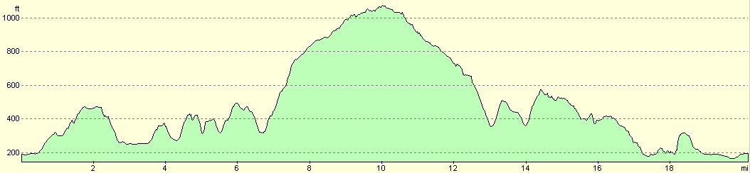
Distances
| From | To | Distance (m) | Ascent (ft) | Descent (ft) |
|---|---|---|---|---|
| Helmsley | Rievaulx | 3.7 | 509 | 377 |
| Rievaulx | Rievaulx Moor trig pillar | 6.3 | 1411 | 666 |
| Rievaulx Moor trig pillar | Hasty Bank Farm | 4.2 | 400 | 1024 |
| hasty Bank Farm | Helmsley | 6.0 | 574 | 827 |
This makes a total distance of 20.2 miles, with 2894 feet of ascent and 2894 feet of descent.
For more information on profiles, ascents and descents, see this page
Accommodation
I spent the night at Five Acre View, a superb B&B situated about a mile to the north of Rosedale Abbey. The room cost me £30.00 for the night, and I awoke both mornings that I stayed there to superb views over towards the moors. The breakfasts were large and filling, and the hot made me feel very welcome. The address is Five Acre View, Rosedale Abbey, Near Pickering, North Yorkshire, YO18 8RE. They can be contacted at (01757) 417830, or by email at fievacreview@aol.com. They have a website at 5acreview.co.uk.
Disclaimer
Please note that I take no responsibility for anything that may happen when following these directions. If you intend to follow this route, then please use the relevant maps and check the route out before you go out. As always when walking, use common sense and you should be fine.
If you find any information on any of these routes that is inaccurate, or you wish to add anything, then please email me.
All images on this site are © of the author. Any reproduction, retransmissions, or republication of all or part of any document found on this site is expressly prohibited, unless the author has explicitly granted its prior written consent to so reproduce, retransmit, or republish the material. All other rights reserved.
Although this site includes links providing convenient direct access to other Internet sites, I do not endorse, approve, certify or make warranties or representations as to the accuracy of the information on these sites.
And finally, enjoy your walking!
Nearby walks
| # | Title | Walk length (miles) |
|---|---|---|
| 715 | A circular walk from Rosedale to Hutton-le-Hole | 20.8 |
|
|

|