Walk #713: A circular walk from Linton to Hempstead
 |
 |
|
General Data
| Date Walked | 11/02/2006 |
| County | Cambridgeshire, Essex |
| Start Location | Linton Church |
| End Location | Linton Church |
| Start time | 08.54 |
| End time | 15.42 |
| Distance | 20.6 miles |
| Description | This was an enjoyable circular walk, and although there was much road walking this was more than made up for by the Bartlow Tumuli. |
| Pack | Today I carried my 30-litre Karrimor rucksack filled with my waterproofs, two litres of water, a book and various other odds and ends. |
| Condition | I feel absolutely fine after this walk, and I could easily have walked further if I had needed to. My right knee ached a little at times, but my left knee was absolutely fine. |
| Weather | The day was generally overcast with occasional sunny periods, although the sun did make brief appearances. It was a mild day for the time of year, and there was not much of a breeze at any time. |
| OS map | Landranger number 154 (Cambridge & Newmarket, Saffron Walden) |
 |
 |
|
 |
 |
|
Map of the walk
Maps courtesy of Google Maps. Route for indicative purposes only, and may have been plotted after the walk. Please let me have comments on what you think of this new format. For a detailed table of timings for this walk, please see the table file.
 |
 |
|
 |
Notes
After last Sunday's walk from Newport in Essex I was keen to do another one in the same area, mainly due to not wanting to drive too far. During the week I had read about the tumuli at Bartlow, and it proved easy to plan a walk that would link Linton with my last walk and the village of Bartlow. I set off quite late because of the short drive, and soon found myself driving through the new one-way system in Linton looking for a car park. After finding one by the health centre, I parked up and was pleased to find that it was free, a nice change from recent events, and it took me only a couple of minutes to get my rucksack packed and start on the short walk through the village to the church.
Linton church is fairly pretty, and I took a few photographs of it from various angles whilst I waited for my GPS to acquire a position from the satellites circling far overhead. I must have looked fairly strange, as a man in a Barbour coat came up and asked me if I was lost, in a what-are-you-doing-here type of way. I replied that I was just starting on a walk, and as he walked away I wrote down my position in the book and set off across a footbridge that led across a little stream by the churchyard.
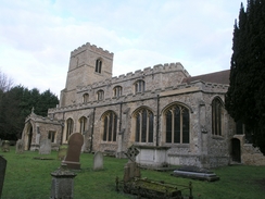
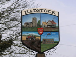
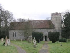
The next stretch of path took me across a field and towards the A1307, which I carefully crossed before taking the road that soon ended at a posh house that had a garden containing the stump of an old windmill. The stump looked strangely sad and useless without the top and sails, almost as if it had been decapitated by some giant. The road ended by an old railway bridge and a bridleway continued on, becoming a green lane with some pleasant views northwards over Linton towards the trig pillar on Rivey Hill. The bridleway became a green lane that ended at a road, that led me on towards Hadstock, where there was an attractive church set amongst the fields. A footpath led me uphill and there were some more good views, although these ended as the path descended down to the farm at Bowsers, where the path entered a little orchard before reaching the farm.
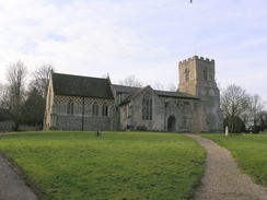
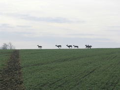
A stretch of footpath through some scrubby woodland and a private track led me up to the Monks Hall trig pillar, which is situated in an exposed position on an old airfield. After taking some photographs I headed on down the track, and then joined a footpath. As I walked along this I saw a large herd of deer cross the field in front of me, running right to left on the horizon. I stopped to watch them run past, and once I restarted I smelt the musky scent that they left in the air behind them; the sight and smell being a memorable experience. The footpath descended down to a farm and here a road led me on to a stretch of road that I had walked along on the last walk, and this sped me on as I headed towards Church end. It took me a couple of minutes to find the entrance to the churchyard as the church was situated behind some houses, but once here I was greeted by a rather messy building, with many additions spoiling the lines of the building.
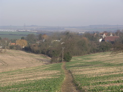
A footpath took me over a hill to Water End, and from here the footpath was less obvious as it headed on towards a road. This led me southeastwards, and I put myself on autopilot as I strolled along, enjoying the sunshine. Another path led on to Cowlass Hall, where the way down the hill to the stile and a bridge over a brook was blocked by an electric fence in a paddock. I ended up taking a long way around which expended much more energy than it should have done, and also put me on the wrong source as I headed uphill and down across fields to reach the B1054. I hit this a little further east than I had wanted, but a gate gave me easy access to the road, which was followed for about half a mile before turning off down a quieter road. As I walked there were many planes in the sky overhead, circling around waiting to land at the nearby Stansted Airport. The road ended and a bridleway continued on, and this was an easy walk until I left the track, by taking a footpath that led off in a more northerly direction. This proved to be a slightly harder walk as the path followed a stream, a ploughed field on the right meaning that I had to follow a narrow strip of grass that made walking easier. eventually the stream was left behind, and a track led me up to a road at Olmstead Green.
The road was pleasantly quiet as I walked along it, and my mind went on autopilot, looking at the scenery on the generally flat terrain. It was an enjoyable stroll and easy on the legs, and before I knew it I was passing the entrance to Great Bendyish Wood and approaching the large radio mast that dominates the area. This was securely fenced off from the adjacent road, but by standing at the fence and looking straight up I could get an impression of the scale of the tall structure. On the other side of the road from the mast compound was a trig pillar, standing a few yards inside a field that had no hedge. I went up to the trig pillar, and after photographing it took my rucksack off and sat next to it, resting my back on the concrete as I rested. The position was fairly sheltered from the wind, and I enjoyed relaxing, looking over the field towards the church at Castle Camps as I daydreamed after past and future walks.
Eventually I realised that I could not sit there daydreaming all day, and so I got up, shrugged my rucksack off and headed down the road, leaving the pillar and the mast behind me. After a few yards I came across an old combine harvester rusting away on the side of the road, and this was followed by other combines and various other tractors and farm vehicles. These were centred around Cooper's Farm, and it was obvious that this farm is used as abase for the repair of various farm implements and vehicles. On the verge outside the farm there were vehicles and implements of all sizes, including a fascinating stretch of verge containing old-fashioned drawn ploughs and mowers. These were nearly covered by grass, and the variety of the vast collection was intriguing. A long road walk followed as I left the farm behind me, heading northwestwards along generally quiet roads. The road passed the tree-lined embankments of the old Cambridge to Haverhill railway line, before angling to head westwards towards Bartlow.
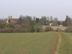
The road took me on into Bartlow, and after a short distance a sign for the church pointed off to the left. I followed it, and was pleasantly surprised to find the that church had a Norman round tower,, which is always a pleasant find. The church dates from about 1300, although some believe that it stands on the site of an earlier church built by King Canute. After the walk I discovered that the church has some good wall paintings, and I wish that I had gone inside to photograph them, but was keen to head on to my main target in the village. A sign pointed me in the right direction down a narrow footpath with a fence on the left. Halfway along the path descended slightly to cross a stream, and over the fence I saw an artistic bridge in a garden. This soon led onto a bridge over an old railway line and as soon as I turned the corner from this bridge I as greeted with a breathtaking sight.
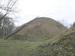
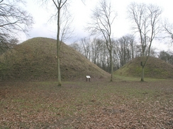
The first of the Bartlow Tumuli greeted me, standing high with steep sides. A few steps further took me to another, even higher tumulus into view, and finally a third one was seen. They were a great sight, and I stood to take in the weight of the three high mounds before walking to the middle one and climbing up the steep steps that led up to the summit. It was a step climb and I was glad that the steps made it easier than the grass slope would have been, and once at the top I was greeted with a hole right in the middle - obviously the remains of a robber pit or archaeological dig. The two smaller tumuli were on either side, and I was surprise to find that the views from the top were not very good due to the surrounding trees. Originally there had been seven tumuli (the biggest group of Roman burial mounds in Northern Europe, and included the highest mound in Britain, 45 feet high and 144 feet in diameter). One of the mounds was destroyed during the construction of the railway, and the other three are basically flattened.
After taking many photographs I headed down the steps, and walked slowly around all three of the mounds, taking in their, well, beauty. The skies overhead were slightly grey, and I can imagine that if the skies were blue the sight would be even more magnificent. I walked through the trees to another path that sudden dumped me onto a road, and I followed this back towards the centre of the village, passing the recently-closed village pub ion the way. Here I was faced with a decision - I had walked about 18.5 miles so far, and I really wanted to walk over twenty. Linton and the end of the walk was not too far away, and I was tempted to walk northwards towards the Roman Road at Mark's Grave before heading back to Linton along a bridleway. This would add another couple of miles onto the walk, but as I had to get back home to get ready for a party I decided to risk it and walk on the direct route. This was on yet another stretch of road walking, and although the road was busier than those than I had been walking along, it was wide and an easy walk. There was not much to see, even when I reached the top of the hill and I got views northwards over Linton towards the water tower on Rivey Hill.
The road descended down gently to reach the A1307 road, which took me a couple of minutes to cross due to the heavy traffic that was flowing along it. On the other side I followed another road, and almost immediately this entered the eastern outskirts of Linton. There was not much of interest to see as I strolled through the village, and it was only when I passed a trial one-way scheme and entered the very centre of the village that the houses started to get interesting, with some pretty decorations on the plaster walls of some of the houses. A path led down to the church, and as I entered from a different direction to the one I had taken in the morning, I had to walk around the church to reach the point where I had started the GPS. Once I had done so I was pleased to find that I had walked 20.5 miles - I had exceeded my target for the day. As I had plenty of time I took my time and took a winding route back to the car park through the village, my legs and feet feeling fine and definitely fit for another couple of miles if I had needed to do them.
Directions
This walk starts off at Linton Church; leave the church and walk eastwards through the churchyard, aiming for a little footbridge over a stream. Cross this footbridge, which leads out into a field. Follow a footpath that heads eastwards across this field, with the stream a short distance away to the left. This path soon ends at a local road; turn right and follow this road as it heads southwards for a few yards to end at the A1307 road. Carefully cross the A1307and once on the other side follow a road that almost immediately curves to the left, passing some cottages before ending by an old railway bridge, with a filled-in cutting beneath it. Here the road ends, but a bridleway continues on southeastwards along he Cambridgeshire / Essex border, before curving to the right to join a green lane that heads southwestwards to end at a road.
At the road heads straight on southwestwards as it descends down into the village of Hadstock. When the village sign is reached turn left and climb up to reach the church; pass this and then turn slightly left to pass some buildings and enter a field. Join a footpath that heads in a rough southerly direction, crossing a stream before climbing uphill along an obvious path that heads across fields. The path summits the hill and then starts to descend down towards the farm at Bowsers, entering an orchard through a gate before exiting through another gate, passing some buildings and reaching a road. Turn right to head west along the road for a few hundred yards until an area of scrub woodland starts on the left; continue on for a few yards past the edge of the woodland, where a footpath heads off to the left. This heads through the trees and passes some old cars and other assorted junk, before exiting at a track.
Turn right and follow this track as it heads uphill to the south; this is noy a public right of way but was an easy walk that soon ended at a T-junction with another track that carries a footpath. Monk's hall trig pillar is a few yards away to the right; turn left and head downhill along another track until a building is reached on the right. Immediately past this building turn right along a footpath that heads southeastwards, climbing uphill and hitting the western edge of a small patch of woodland before descending southwards down a field to meet the end of a road near a farm. Join this road and follow it as it heads south, curving around for a little over a kilometre before ending at a T-junction near Ash Tree Farm. At this junction turn left, and follow another road that heads northeastwards for about a kilometre until it curves sharply to the left in Church End.
After this bend turn right through a gate that leads through the churchyard to the church; pass the church and at the end of the churchyard turn right and leave the churchyard through a gate, passing some attractive cottages on the way. Turn almost immediately to the left along a footpath that enters a field, and then turn right along a footpath that crosses some rough ground before climbing up a slight hill with a hedge on the left. The path descends to meet a track, continue straight on along this track as it heads southeastwards to reach a road at Water End. Head on along this road southwards for a few yards, and then turn to the left to start following a footpath that heads southeastwards. Initially there is a hedge on the left, but once a stream is reached this is left behind and the path becomes harder to follow as it continues on for another couple of hundred yards before ending at a road.
Turn right and walk southeastwards along the road for a couple of kilometres; the road passes Bendysh Hall on the left; take the first road off to the left, which heads eastwards for a couple of hundred yards before the road curves to the left. Here a footpath leads off to the right, heading southeastwards along a track that leads to Cowlass Farm. When the farm is reached the footpath continues on downhill towards a stream, but my way was blocked by electric fences and so I had to make a diversion to get access to the little footbridge over the stream. After this the footpath is harder to follow on the ground as it climbs uphill to the southeast, going over a slight hill before descending downhill to reach the B1054 near Sellands farm.
Carefully walk eastwards along the B1054 until a farm is reached on the right; here Wincelow Hall road leads off to the left. Initially this heads northwards before gently curving to take a more northeasterly course, passing Wincelow Hall and a road junction to the right before ending near Great Dawkins. When the road ends a byway continues on; follow this for about half a kilometre until just after it has crossed a stream, and then turn left to start following a footpath that runs along the eastern bank of the stream. This curves to the left after a while, and shortly after this a track is reached to the right. Turn right and start heading up this track , which heads in a more or less northerly direction before ending at a road immediately to the east of Olmstead Green.
Turn left and start walking along this road, which passes through Olmstead Green before curving to the right and heading northwestwards towards a tall transmission mast on the left and trig pillar on the right. The road continues on, passing Cooper's Farm, and, abut a kilometre further on, Castle Camps, before reaching a T-junction. Turn let at this junction, and follow a road as it heads northeastwards, eventually passing the abutments of an old railway line where it curves to the left to head in a more westerly direction for the last mile into Bartlow. Enter the village and before the crossroads is reached turn left down a little footpath that is signposted for the church. Enter the churchyard and follow another footpath that heads off to the left of the church, leaving the churchyard and following a narrow path between fences. This dips down to cross a stream before rising to an old railway bridge; cross this bridge and on the other side the path opens out to the Barlow Hills tumuli.
Pass the first tumuli on the right and the turn right along a path that leads away from the tumuli, heading westwards through a wooded area for a short distance before ending at a road. Turn right to head north along this road for a couple of hundred yards until it ends at a crossroads, and then turn left to start following a new road northwestwards. The road climbs up a hill, and then starts slowly descending, passing Barham Hall on the left before ending at the A1307. Carefully cross the main road, and on the other side take a road that heads slightly north of west, soon entering the outskirts of Linton. Continue on along this road as it heads into the centre of the village, where it johns the B1052 and continues on westwards. Just before the road starts to head downhill to cross a little river, turn left along a footpath that heads down a surface track to reach the church, where this walk ends.
Distances
| From | To | Distance (m) | Ascent (ft) | Descent (ft) |
|---|---|---|---|---|
| Linton church | Church End | 6.0 | 475 | 312 |
| Church End | Olmstead Green | 7.4 | 415 | 322 |
| Olmstead Green | Bartlow church | 4.5 | 105 | 312 |
| Bartlow church | Linton church | 2.7 | 92 | 141 |
This makes a total distance of 20.6 miles, with 1087 feet of ascent and 1087 feet of descent.
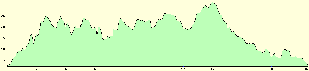
For more information on profiles, ascents and descents, see this page
Disclaimer
Please note that I take no responsibility for anything that may happen when following these directions. If you intend to follow this route, then please use the relevant maps and check the route out before you go out. As always when walking, use common sense and you should be fine.
If you find any information on any of these routes that is inaccurate, or you wish to add anything, then please email me.
All images on this site are © of the author. Any reproduction, retransmissions, or republication of all or part of any document found on this site is expressly prohibited, unless the author has explicitly granted its prior written consent to so reproduce, retransmit, or republish the material. All other rights reserved.
Although this site includes links providing convenient direct access to other Internet sites, I do not endorse, approve, certify or make warranties or representations as to the accuracy of the information on these sites.
And finally, enjoy your walking!
Nearby walks
| # | Title | Walk length (miles) |
|---|---|---|
| 10 | Waterbeach to Great Chesterford via Cambridge | 21.0 |
| 49 | Bishop's Stortford to Great Chesterford | 14.9 |
| 63 | Great Chesterford to Cambridge | 16.8 |
|
|

|