Walk #712: A circular walk from Newport
 |
 |
|
General Data
| Date Walked | 05/02/2006 |
| County | Essex |
| Start Location | Newport (Essex) |
| End Location | Newport (Essex) |
| Start time | 09.28 |
| End time | 16.11 |
| Distance | 20.5 miles |
| Description | This was a long circular wlk in western Essex, going through some nice, rural countryside on a lovely winter's day. |
| Pack | Today I carried my 30-litre Karrimor rucksack filled with my waterproofs, one and a half litres of water, a book and various other odds and ends. |
| Condition | I had a little trouble with my right knee at times, but this was not really significant. Aside from this the underside of my feet hurt, and I have developed a blister on one of my toes. |
| Weather | The day was initially bright and sunny, although it was a hazy day that forshortened any views. As the day went on the haze lifted but clouds also rolled in until the sun was totally obscured. It was a cold day and the little wind that there was was cold. |
| OS map | Landranger number 167 (Chelmsford, Harlow & Bishop's Stortford) and Landranger number 154 (Cambridge & Newmarket, Saffron Walden) |
 |
 |
|
 |
 |
|
Map of the walk
Maps courtesy of Google Maps. Route for indicative purposes only, and may have been plotted after the walk. Please let me have comments on what you think of this new format. For a detailed table of timings for this walk, please see the table file.
 |
Notes
I have had this walk planned for some time, and as I did not want to have to set off too early in the morning after the epic early start last Saturday, I decided on doing this fairly local walk. It cost me one pound to park at Newport station car park, which seemed slightly odd as mine was the only vehicle in the car park. It looked as though it would be a nice day, and after getting my boots and rucksack on I locked my car and headed across the station footbridge to get over to the eastern side of the railway line and join the Harcamlow Way, which I would be following to Audley End.
A nice stretch of footpath took me up a slight hill along the edge of a green field, and I was disappointed to find that the views back over Newport were spoilt by a haze that hung in the air. The path dumped onto a road near Ringers, and as I crossed the road to join the next stretch of footpath I saw a couple of deer close by in the field to the north. I stopped to study them whilst they were grazing, but as soon as I got my camera out they bolted, and unfortunately I only managed to get a photograph of them running away down the field.
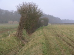
The footpath that led down to Debden Water was initially between two hedges, but it soon opened out as it headed down a field to the stream. A little bridge led over the stream, and on the other side I was unsure which way to go; a look at the map showed me that I had to head eastwards for a short distance through some trees before heading on up the hill. This slope was not too steep, and I made good time as I headed uphill onto Debden Common. It was a nice walk, and although it was cold the sun warmed me up when I was not exposed to the slight breeze. On the map the path followed a track, but on the ground there was very little sign of this path on the ground, although the footpath signs made it quite easy to find the correct route.
When the path crossed the B1052 road I was tempted to turn right and follow this into Saffron Walden, but instead I decided to continue on along the Harcamlow Way into Audley End. Again there was a track marked on the map, but it was just a footpath that followed a stream northwestwards, but it was easy to see the correct route on the ground, even when a dog being walked by a couple ran up to me and started snarling menacingly. Abbey Farm was fairly nondescript, but it was followed by a grand building (St Marks College, a residential youth and conference centre) on the left and then by a beautiful street of houses in Audley End itself. The houses on other side of the road were very pretty as they rose up the slight hill, and the black and white colour scheme contrasted well against the blue sky overhead.
The village comprises of little more than this row of houses, and as I reached a T-junction with another road near the small post office I came across Audley End House. This is a very grand building, but unfortunately on this walk all I got was a quick glimpse of it through the trees before the high brick wall that runs alongside the wall blocked my view. The house used to be three times its present size, which was once one of the finest Jacobean houses in Britain. I followed the wall along the road for a while, before a gate within the wall allowed me to enter the park and follow a footpath northeastwards towards Saffron Walden. It was annoying that I could not see the house as I walked, but I consoled myself with what was a pleasant walk and, after exiting the park through an identical gate, I was in Saffron Walden.
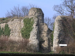
Almost unbelievably I have never been to Saffron Walden before despite having lived in and around South Cambridgeshire for many years. Many of my friends had commented on how nice the town was, and so I was not disappointed when I reached the centre and found it to be a fairly nice place. At a newsagent I nipped in and bought myself some chocolate, before heading out past a park to reach the ruins of Saffron Walden Castle. The ruins of this castle are safely behind a fence which meant that I could not visit it without going into the adjacent museum, but what I could see were quite high flint ruins of a Norman Keep. The original castle was built between 1125 and 1141, and it was rebuilt in stone in 1347; the ruins that can be seen today are the foundations that were for years hidden by the motte.
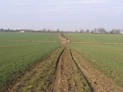
A fairly boring suburban road took me northeastwards out of the town, and a pleasant stroll along a bridleway followed across green fields. It was an easy, flat walk, and I made good time as the path slowly descended down to meet the end of a road at Butlers Farm, and this was followed by another easy walk, this time along a footpath, until another road is reached. Here I left the Harcamlow Way and followed the road, passing the embankments of the old Audley End to Bartlow railway line, opening in 1866 and closing in 1964. The bridge was missing and it was easy to miss that there had actually been a railway line here; if it had not been for the embankments markings on the Ordnance Survey map then I would have missed it.
Some road walking took me towards Church End, but before the village was reached I took a footpath that led off to head southeastwards across fields. Unlike all of the other footpaths that I had followed so far today I found navigation to be slightly difficult, and it was only dead reckoning that allowed me to find the footbridge over the stream at the bottom of the hill. Once across the bridge the path headed uphill, passing some friendly horses to a farm at Ivytodd. Here I had planned to follow a footpath that would lead me south, but I could not find it within the farmyards and so took a slightly longer way around via the road.
It did not take me long to get back onto the proper track, and I found this to be heavily churned up by horse's hooves, although fortunately this was not muddy due to the lack of recent rain. The rough ground made the going harder than it should have been, and it was a relief when I eventually turned off the bridleway to join another bridleway that soon reached a trig pillar. By this stage I was in need of a little rest, so I cleared a space of a few brambles and sat down with my back to the pillar, looking out across the fields to a radio mast.
The bananas that I had packed were slightly mushy but tasty nonetheless, and I devoured them ravenously as I swigged down some water out of my bottle. Eventually I started to get chilled by the wind so I got up and headed on along the bridleway, which although churned up was not as bad as the previous bridleway had been. Once across a road the condition of the bridleway improved, and I made good time before reaching the end of a track at Stocking End. Here I had to walk along a main road, but this was fortunately not too busy, although I was relieved when I turned off to head down a quieter road.
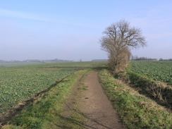
When I planned this walk it had been my intention to turn off the road and head west along a bridleway down to Howlett End, but I did not fancy walking along more churned-up bridleways, and the light traffic on the road made the decision not too easier. The only bad point about the decision was that there was not much to see as I plodded along the road; there were not many views and so I just put my head down and walked. At the end of the road I joined a footpath that led down to Rowney Wood, where there was much more of interest to see in the light and airy surroundings of the trees. Once out of the woods the path headed westwards across a field, and to my right I was surprised to see an airfield radar rotating. Looking at the map, it was easy to see that this belonged to Carver Barracks immediately to the north, where the 33 Engineer Regiment (Explosive Ordnance Disposal) is based. There is also a Kart club on the airfield site, although I doubt the radar is used for them!
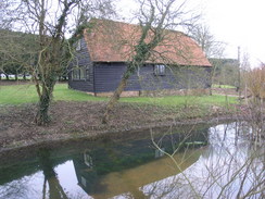
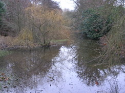
When the path ended at a road in Debden I found it hard to work out which way I had to go. Additionally, the batteries on my GPS had just failed, and this meant that after a couple of minutes I realised that I had turned the wrong way down the road. Looking at the GPS track log when I came back I discovered that somehow I had entered Debden down the wrong road, and this had caused me to head off the wrong way. It did not take me long to get back on track, and I soon found myself heading down the road that led to the pretty Debden Church, sitting low down near a lake. I nipped in to have a quick look around the interior, and then headed out and downhill towards the lake, passing a massive barn on the way.
From the lake a bridleway led up to a road, and as I was feeling fit I decided to extend the walk a little further. My intention had been to walk along the road west to Ringers and then head back along the first part of the day's route to the station in Newport, but instead I decided to head south to Waldegraves, and pick up the main road to the south of the village. This would have the advantage of increasing the mileage of the day's walk to over twenty, and so I headed off own he road. There was not much really to see as I walked along the quiet road, the major thing of note being at Waldegraves, where I crossed the route of a previous walk. Eventually the road climbed to cross the railway line on a bridge, and descended to cross the River Cam, here barely more than a trickle, before ending at the main road. A quick yomp up the road took me into Newport, and shortly afterwards I arrived at my car in the station car park, after what had been a thoroughly enjoyable stroll.
Directions
This walk starts off at Newport railway station. Cross the footbridge over the railway line and go onto the lane; turn left along this lane foe a few yards and then turn right along a footpath that initially climbs up a blank to enter a field. The footpath heads straight on across the field before turning to the left to skirt the edge of the field. It is easy to follow the path as it heads eastwards, ending at a road near Ringers. Cross the road and turn right for a few yards, towards a bend, and then turn left along a footpath that heads downhill between two hedges towards Debden Water, the path opening out into a field before the stream is reached.
Cross the stream via the bridge, and on the other side turn right along the northern bank of the stream for a few yards until it emerges out from some trees; here turn left and start following a footpath that heads northwards uphill along a field. The footpath skirts the western edge of some woodland before curving slightly to the left to head towards dome other woodland; before this is reached it turns to the right and heads northwards, descending to skirt the eastern edge of another patch of woodland.
At the northern corner of the woodland the path meets Fulfen Slade brook, and although there is a track marked on the OS map going north from here, this was not very clear on the ground. Continue northwards with a hedge on the left, and after about a hundred yards the path goes through the hedge to the left and continues northwards with the hedge on the right. Although the track on the ground is unclear the path is easy to follow as the hedge is kept on the right as it continues northwards to meet the B1052 road.
The path climbs up onto the B1052 road; cross the road and then head down a footpath on the other side. Initially there is a stream on the right, but the footpath crosses this after a while and continues with the stream on the left before reaching a small car park and a minor road. Cross this road and then continue on along a track that leads towards Abbey Farm, curving to the left to pass the farm before curving to the right and rising slightly through Audley end to reach a minor road. Cross the road and turn right, keeping the wall of Audley End Park on the left as the road is followed eastwards. After a few hundred yards a gate is reached through the wall on the left; go through this gate and follow a footpath that heads northeastwards across Audley End Park.
This descends to exit through another gate onto Abbey Lane; join Abbey Lane and head straight on eastwards for a short distance until the B184 High Street is reached. Cross the High Street, and continue straight on along Hill Street through the centre of the town. When a junction is reached turn left to head northwards up a slight hill with a park on the right; pass the castle on the left and then turn right to walk eastwards up Pound Walk. This road soon ends, but a wide footpath continues on for a short distance before joining Shed Lane. Continue northeastwards up Sheds Lane, and when it ends continue straight on along a bridleway.
The bridleway heads northeastwards before turning sharply to the left to head towards Byrds Farm; before the farm is reached it turns sharply to the right to resume on a northeasterly course. The path skirts an area of woodland before descending downhill across a field to cross a stream; note the bridleway does not follow the edge of the woodland but cuts across the field instead. Once across the stream, the path ascends up a slight slope to meet a track by Butlers Farm. Cross this track and keep the barns to the right as a footpath continues on, initially taking a more easterly course before curving to head northeastwards and ending at a road.
Turn right along this road and follow it as it heads southwards for a few hundred yards before ending at a T-junction Turn left along this road and follow it as it heads northeastwards towards Church End for a little under a kilometre. At a left-hand bend just before the village turn right to join a footpath that heads downhill so the southeast, nearing Little Hales Wood before reaching a stream. Cross the stream using a hard-to-find footbridge, and continue along the footpath as it heads uphill across a field towards the farm at Ivytodd. The path passes the farm, and then turn left to join the end of a road.
Turn right and follow this road as it heads southeastwards; when it curves to the left near Sprigg's Farm turn right along a track that curves around to the right, before curving to the left to reach two cottages on the right. The track becomes a rough bridleway that heads southwestwards for about a kilometre, and shortly before a large transmitter mast is reached turn left to join another bridleway. This bridleway heads southeastwards, with a hedge on the left, soon passing a trig pillar beside the hedge before reaching a road. Cross this road, and on the other side the bridleway continues on southeastwards, skirting an area of woodland before reaching a track near Stocking Green. Turn right down this track, and follow it for a short distance until it ends at the B1053 road.
Turn left and follow the B1053 southeastwards for a little under a kilometre until the little hamlet of Maple End is reached, and then turn right to start walking down another road. This road leads to Wimbish, Tye Green and, after a couple of miles, a main road neat Howlett End. Cross the main road and ignore the road that heads off to the south, and instead head southewestwards along a footpath that leads across fields towards Romney Wood. The path enters Romney Wood and heads straight through the middle of it, becoming a track for a period before leaving the wood in a more westerly direction as a footpath.
Once the footpath emerges from Rowney Wood it heads westwards through fields, with a hedge on the right. It is easy to follow as it does so, and it eventually meets the end of a track near Deynes Farm that can be followed westwards until it ends at a road in Debden. Turn right along this road, and before the pub is reaches on the right turn left down a road that is signposted for the church. Head on down the road and pass the church, and when a track junction is reached turn left, crossing a little bridge over a lake. Continue on along the track for a few yards and then turn right at a footpath sign to join the footpath, which heads up a slight slope to the west.
When this footpath ends at a road continue straight on westwards along the road. It soon curves sharply to the left to head in a more southerly direction, passing Waldegraves and eventually ending at a junction to the northwest of Widdington. At this junction turn right, to head northwestwards along another road for about a kilometre, after which the road climbs to cross a railway line and the River Cam, before ending at a T-junction with the B1383 road. Turn right to start following the B1383 road northwards; there is a pavement beside the road, and it soon enters the southern outskirts of Newport. Head through the village, and after passing a garage on the right turn right down a road that leads eastwards for a hundred yards to the railway station, where this walk ends.
Distances
| From | To | Distance (m) | Ascent (ft) | Descent (ft) |
|---|---|---|---|---|
| Newport | Saffron Walden | 5.0 | 409 | 410 |
| Saffron Walden | Maple End | 7.7 | 458 | 328 |
| Maple End | Newport | 7.8 | 275 | 404 |
This makes a total distance of 20.5 miles, with 1142 feet of ascent and 1142 feet of descent.
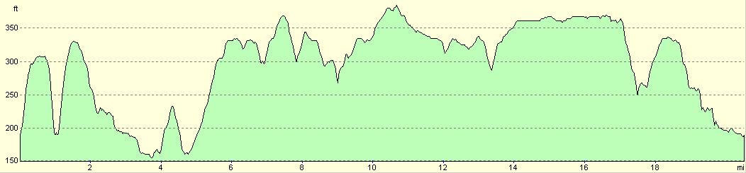
For more information on profiles, ascents and descents, see this page
Disclaimer
Please note that I take no responsibility for anything that may happen when following these directions. If you intend to follow this route, then please use the relevant maps and check the route out before you go out. As always when walking, use common sense and you should be fine.
If you find any information on any of these routes that is inaccurate, or you wish to add anything, then please email me.
All images on this site are © of the author. Any reproduction, retransmissions, or republication of all or part of any document found on this site is expressly prohibited, unless the author has explicitly granted its prior written consent to so reproduce, retransmit, or republish the material. All other rights reserved.
Although this site includes links providing convenient direct access to other Internet sites, I do not endorse, approve, certify or make warranties or representations as to the accuracy of the information on these sites.
And finally, enjoy your walking!
Nearby walks
| # | Title | Walk length (miles) |
|---|---|---|
| 10 | Waterbeach to Great Chesterford via Cambridge | 21.0 |
| 49 | Bishop's Stortford to Great Chesterford | 14.9 |
| 63 | Great Chesterford to Cambridge | 16.8 |
|
|

|