Walk #10: Waterbeach to Great Chesterford via Cambridge
General Data
| Date Walked | 06/02/1999 | |||
| County | Cambridgeshire, Essex | |||
| Start Location | Waterbeach | |||
| End Location | Great Chesterford station | |||
| Start time | 08.00 | |||
| End time | 14.49 | |||
| Distance | 21.0 miles | |||
| Description | A reasonable walk. Felt fine until about 15 miles in. After that things became a bt of a strain. Got to Great Chesterford just in time to catch the 14.19 back to Cambridge - which was quite amazing considering I didn't have a timetable ;-) I spent some time doing a little shopping in Cambridge City Center, and lost a little time in Duxford due to being dozy and taking a non-optimal road ;-) | |||
| Pack | Today's pack was of medium weight - it did not contain full walking gear, but was fairly heavy nonetheless. | |||
Condition | Weather | Started fine until I got south of Cambridge, and then the heavens opened with a constant drizzle. Got fairly wet, but the craghoppers trousers dry *very* quickly. | OS map | Landranger number 154 (Cambridge & Newmarket, Saffron Walden) | |
Map of the walk
Maps courtesy of Google Maps. Route for indicative purposes only, and may have been plotted after the walk. Please let me have comments on what you think of this new format. For a detailed table of timings for this walk, please see the table file.
Notes
I wanted to do a relatively long walk today, and one that would connect my flat in Waterbeach with the centre of Cambridge. To extend it further, I decided to stroll from Cambridge to the station, then out southwards to Great Chesterford. It was a long walk in far from ideal weather, and was also mostly along roads, except for a short stretch of footpath between Duxford and Ickleton.
Directions
Directions(Note that these directions are from my flat in Bannold Road, Waterbeach; to walk it from the centre of the village remove 1/2 a mile, and from the railway station 3/4 of a mile).
Walk along Bannold Road towards Bottisham Lock and the River. Once the river has been reached, follow the western bank southwards until you reach the road near the railway station. Cross over the road, and take a path in the field opposite which follows the road. This brings you out by the river just upstream of the road bridge.
Follow the river for a couple of miles. This is a very nice section of river and a joy to walk. Eventually you reach Bait Bite Lock, just south of a path leading to the village of Milton. Do not cross over the bridge, but instead continue along the river bank for a couple of miles. It passes under the A14. Shortly after passing under a railway bridge the path leaves he riverbank and follows a road paralleling the river until a pedestrian bridge is reached.
Cross the bridge and turn right to start following the southern bank of the river southwestwards. Continue on for another one and three quarter miles until Magdelene Bridge is reached. Here climb up onto the bridge and turn left to start heading southeastwards through the city centre. The road becomes Bridge Street, Sidney Street, Andrew's Street and Regent Street until it meets the ring road and becomes the A1307 Hills Road.
Head southeastwards along Hills Road; if you wish to visit Cambridge station, then at the war memorial turn left to head eastwards for a quarter of a mile. If not, then continue on along Hills Road for a couple of miles until a large roundabout is reached outside Addenbrokes Hospital. Continue straight on along the A1307 for half a mile until Granham's Road leads off to the right.
Turn right and follow Granham's Road for a mile and a half as it climbs over a hill southwards; there are no pavements but the road is not too busy. The road crosses a level crossing before ending at the A1301 on the northern outskirts of Great Shelford. Turn left for a few yards and then right, to head along the High Street through the village. Continue on as the church is passed on the right, and the road crosses the River Cam or Granta.
Shortly before Little Shelford church is reached on the right, turn left down Whittlesford Road. Follow this southwards for 2.5 miles; at a junction continue on eastwards into Whittlesford. Pass through the village and head southeastwards down Duxford Road for a mile and a half into Duxford; on the way it crosses the A505 main road.
When St Peter's church is reached on the left, turn right down St Peter's Street for a fifth of a mile. At a crossroads turn left to head southeastwards down Ickleton Road. A footpath leads off after a third of a mile; follow this path as it parallels the road until TL483448, where the path turns to the left to head northeastwards. At a footpath junction at TL486450 turn right and follow this footpath southeastwards for nearly a mile until it ends at Butcher's Hill in Ickleton. Turn right down this road, and then take the first road off to the left to head south along Froge Street. This passes under two branches of the M11 road before reaching London Road on the outskirts of Great Chesterford. Take the first track off to the right, which leads to Great Chesterford station, where this walk ends.
Distances
| From | To | Distance (m) | Ascent (ft) | Descent (ft) |
|---|---|---|---|---|
| Waterbeach | Cambridge Station | 8.9 | 66 | 23 |
| Cambridge Station | Whittlesford | 7.1 | 157 | 135 |
| Whittlesford | Great Chesterford Station | 5.0 | 171 | 125 |
This makes a total distance of 21.0 miles, with 394 feet of ascent and 283 feet of descent.
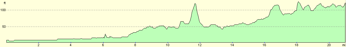
For more information on profiles, ascents and descents, see this page
Transport
There are regular train services between Great Chesterford and Waterbeach, changing at Cambridge. A single ticket costs £6.80.
Disclaimer
Please note that I take no responsibility for anything that may happen when following these directions. If you intend to follow this route, then please use the relevant maps and check the route out before you go out. As always when walking, use common sense and you should be fine.
If you find any information on any of these routes that is inaccurate, or you wish to add anything, then please email me.
All images on this site are © of the author. Any reproduction, retransmissions, or republication of all or part of any document found on this site is expressly prohibited, unless the author has explicitly granted its prior written consent to so reproduce, retransmit, or republish the material. All other rights reserved.
Although this site includes links providing convenient direct access to other Internet sites, I do not endorse, approve, certify or make warranties or representations as to the accuracy of the information on these sites.
And finally, enjoy your walking!
Nearby walks
| # | Title | Walk length (miles) |
|---|---|---|
| 2 | Waterbeach to Newmarket Road, Cambridge | 5.4 |
| 5 | A short walk around Waterbeach to Car Dyke | 3.0 |
| 6 | Waterbeach to Newmarket Road, Cambridge | 5.4 |
|
|

|