Walk #764: Spoad Hill to Buttington Bridge
 |
 |
|
General Data
| Date Walked | 05/04/2007 |
| County | Shropshire, Powys |
| Start Location | Spoad Hill |
| End Location | Buttington Bridge |
| Start time | 07.25 |
| End time | 19.08 |
| Distance | 21.7 miles |
| Description | Initially this walk followed Offa's Dyke as it plunged up and down some severe ascents and descents, before flattening out past Montgomery. A final stiff climb up to the old fort at Beacon Ring was followed by a descent down to the Severn Valley. |
| Pack | Today I carried my 80-litre Macpac Glissade rucksack, containing a North Face Blue Kazoo sleeping bag, my North Face Westwind tent, clothes, waterproofs and other camping items, including cooking gear. |
| Condition | I am very tired after this walk, but I have no significant problems to report aside from a little stiffness in the legs. |
| Weather | Today was a pleasant, sunny day with not many clouds in the sky. The chilly winds of the last few days had died down, and thus it ended up being a pleasantly warm day, but not so hot that the walking was uncomfortable. |
| OS map | Landranger number 137 (Ludlow & Church Stretton, Wenlock Edge) and Landranger number 126 (Shrewsbury & Oswestry) |
 |
 |
|
 |
 |
|
Map of the walk
Maps courtesy of Google Maps. Route for indicative purposes only, and may have been plotted after the walk. Please let me have comments on what you think of this new format. For a detailed table of timings for this walk, please see the table file.
 |
 |
|
 |
 |
|
Notes
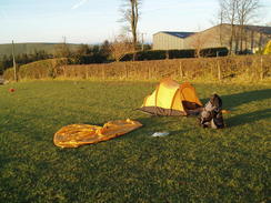
I awoke this morning to find the inside of my tent damp with condensation; it had been a warm night and there had been little wind to help drive the moisture away. This was a pleasant surprise as the main feature of the weather over the first four days of the walk had been the brisk wind, and it was almost strange to find that it was no longer present. I had had an uncomfortable night's sleep as halfway through the night I had rolled over and my right shoulder gave a large crack. Thereafter whenever I rolled over onto that side it would hurt, waking me.
The day ahead promised to be a fairly strenuous one and I was keen to set off, but first I waited for the sun to rise a little higher so that it may dry the tent out a little. I therefore packed everything else up and laid the flysheet flat out on the grass, but after half an hour the sun was nowhere near warm enough, so I packed up my tent and headed off before seven thirty.
A very steep and seemingly never-ending descent followed as the trail headed down to reach a road at Lower Spoad, after which a level stretch took me on to a footbridge over the pretty River Clun at Bryndrinog. A little climb - the first of the day - took me up to a road, and after passing a water tap a very steep climb started. With the weight of the pack weighting me down I had to take my time on the ascent and used the time to look down over the village of Newcastle visible over the dyke to my left.
As soon as the gradient had slackened the trail was descending once again into a little valley, after which the lost height was more than gained up a steep slope. I had to zigzag my way up this slope, and although it was not that high I found the climb to be energy-sapping.
I consoled myself with the knowledge that I was now halfway through the trail, Newcastle marking the halfway point, and I was soon descending along a path that slowly descended alongside the dyke alongside the western flank of Graig Hill. Near a pond I was surprised to see patches of frost and sheens of ice on a pond - I had not been aware that temperature had not dropped down so low last night. Eventually a stream as crossed and a road reached, and another, thankfully gentler, climb started uphill across fields to another road at Hergan.
This marked the start of perhaps the hardest stretch of walk on the entire trail, although it started innocuously enough with a gentle climb northwards alongside the dyke. For some time I had felt my tent, which was strapped horizontally under the lid of my rucksack, moving, and as I took my rucksack off the tent fell out onto the ground, forcing me to take an unscheduled stop. I used this opportunity to take my fleece off, as although it was still early in the day it was already quite hot. A descent was followed by another climb up to the farm at Middle Knuck, where loud music was blaring out despite the early hour - it was a good job that the farm has no neighbours! A sign stated that the farm was run by Crisis Care, a Children's charity..
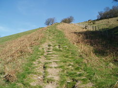
The path climbed once more from the farm, before dropping steeply to reach a road at Churchtown. Throughout the stepped descent I could see the dyke and path heading up a seemingly impossibly steep hill in front of me, and so when I reached the bottom I sat down, resting my rucksack on a stile without taking it off and ate an apple, resting for the climb ahead. The guidebook states that this ascent takes you up 100 metres in around 400 metres horizontal distance, and it certainly seemed this steep. Eventually I decided not to prevaricate any longer, and started off up the slope, taking small, slow steps and hauling myself up slowly. I was soon huffing and puffing away, and I was having to use my walking poles in order to stop myself falling backwards back down the hill.
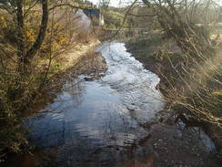
It was a relief when the gradient slackened and I could speed up slightly, although the path still continued to rise up towards the top of a hill. The next descent started gently, the path crossing a road before getting increasingly steep as it headed downhill to cross the River Un, which is nestled in a pretty little valley In places the descent was so steep that I was probably descending at the same sped that I had ascended the other side of the hill! The descent caused my left knee to start hurting, and this was aggravated by the start of another ascent, this time following a track and then a path that headed up through Nut Wood.
Once the path left the trees the gradient slackened, and a road was reached on the top of Kerrys Hill. As I reached the top I started to curse King Offas for building his dyke over terrain that was quite so hilly! At a nearby road there were a couple of other walkers, and a few yards down he road two groups of walkers carrying large wooden crosses - I assumed that these were other people going to the Holy Week meetings in Newtown, along with the people that I had met outside of Hay-on-Wye.
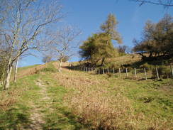
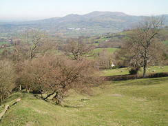
This was the last significant ascent for quite a while, and what followed was a long descent over fields alongside the dyke, with some good views north over the plains ahead. At one point there is a quarry in the way,and the path carefully winds around the side of this - it would be easy if lost to fall over the edge, in my opinion, and shortly after this a road was reached. This road took me northwards as it continued to descend towards the village of Cwm, and continued on towards Lower Cwm. When the road turned sharply to the road a footpath continued onwards, following the line of the dyke before entering trees by a caravan site at Mellington Hall. It was a pleasant enough walk, although in places the path was narrowed by the trees on either side.
Eventually the path reached a main road after passing through an elegant archway, and then passed over Brompton Bridge with an elegant old mill on the right. Soon I reached the Blue Bell Inn, and this seemed like as good a place as any for a rest. As the door was shut I was unsure if the pub was open, and I poked my head around the door to find a woman, Helen, behind the bar; she told me that she was open, and I went into the small, empty bar, shrugged my rucksack off and sat down in a corner.
As I supped my usual two pints of lunchtime liquid a couple of retired men came in wearing suits, and over the next twenty minutes more came in, until eventually the entire bar was filled with elderly men. They were here for a weekly meeting of a Probus group for retired men from a near by town, and a nicer group of men it would be hard to find. One in particular organised a local walking festival,and we spent ten minutes talking about Offa's Dyke path.
Eventually I had to leave, and although I had only had one pint of alcohol it had gone straight to my head, and I slightly wobbled as I crossed the road and started following the trail northwards. Sitting on a stile nearby I was surprised to find Gary, whom I had met yesterday, sitting on a stile eating lunch, and after chatting for a minutes we continued along the trail together.
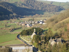
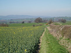
The terrain was infinitely easier than it had been in the morning as the trail rose and fell gently as it crossed fields, and the time flew as we chatted. The weather was sunny and there was no wind, and to the left eventually some good views over to the castle at Montgomery became visible. The chats helped keep my mind off the relatively boring walk, and before I knew it we were crossing the footbridge over the strangely-named River Camlad and were greeted with the first ascent of note in several miles. I actually felt fit and slightly left Gary behind as I climbed this, not wanting to break my (albeit slow) stride as I headed uphill.
At the top of the climb the terrain flattened, and there were yet more little rises and falls before the trail followed the dyke for a short distance and then joined the side of the busy B4388 road. At the pub I had phoned up a pub at Buttington hoping to camp there, and I had made it clear that I might not make it that far. As the afternoon was wearing on I was very tempted to stop in Forden, which was soon reached along the road, but instead I decided to press on, knowing that this would mean the second twenty-mile plus day in a row.
Gary was still slightly behind me at this stage, but as soon as the trail started climbing uphill along a road northeastwards out of the village he caught up with me; it was obvious that I was slowing him down, but he kindly stayed with me and we chatted as the trail left the road and continued to climb through the trees of Leighton Wood. At times there were some pleasant views through the trees, but I was more concerned with tackling the climb; the exertions of the morning had taken more out of me than I had realised, and it was a relief when it started to descend steeply though the trees to join a track.
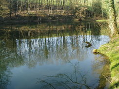
A little distance along this track there was an obvious long-disused dam, the bottom of which was a small pool of water in a large damp, weed-filled area. This was Offa's Pool, once used to supply water to the Leighton Estate. It was quite a pleasant sight, and I took some photographs of the dam as the track went in a level horseshoe around it's edge. Unfortunately the track soon started climbing once again to reach another, much smaller but still full pond, after which it got steeper to reach a road.
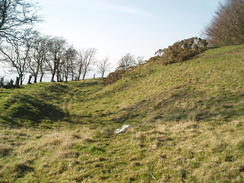
I was really suffering at this stage, and the ascent took it out of me a little, and I think that Gary was also suffering a little. The road came as a welcome, albeit short respite, and another climb took us both up to the hill fort at Beacon Ring. The centre of this was filled with some fairly densely-planted trees, and as Gary walked along the top of the solitary bank of the fort I diverted inwards to find the trig pillar marked on the map. It was dark under the dense cover, although I soon found the pillar and emerged from the trees to find Gary waiting for me by a reservoir at the point where the path left he ring.
The hill fort marked the top of the last climb of the day, and we started a descent down through an area of dark coniferous woodland, the ground underfoot covered with a bland layer of fir needles. Once out of the trees the views to the north became better, and we started to see Buttington, still seemingly a long way away. Gary had booked himself into a B&B in the tiny village, and as he phoned up the owner to see exactly where it was I stood around, resting myself for the long descent ahead. During the conversation I asked him to ask the owner if there was another room available, and when I found out that there was I decided to book myself in. I was slightly annoyed with myself for not camping out, but after two long and hard days of walking I was in need of getting a shower and a proper rest.
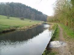
Eventually I located the B&B on the map, and with a groan I realised that it was about half a mile further on from where I had been planning to stay. The descent seemed to take forever and was hard on my tired legs and feet, so it was a relief when the path met a main road for a short distance, and Gary strode ahead of me. The crossing of the River Severn at Buttington Bridge was difficult due to the narrowness of the bridge, and traffic in one of the carriageways actually had to stop to let us cross. On the other side Offa's Dyke path headed along the western bank of the river, but we shuffled on along the road following an alternative route towards the Montgomery Canal. Here we turned right, and a highly pleasant walk along the canal towpath led us to the B&B, situated in at The Moors Farm, where, coincidentally enough, I had turned my car around last year when driving back from Welshpool.
We were both totally tired out when we arrived at the B&B, but the owner quickly made us feel very welcome. Indeed, the rooms were superb, and I immediately stripped and had a long shower that helped take most of the stress and strains out of my body. The pub was a long walk away, and so the owner had offered to drive us into Welshpool for a meal. I therefore went down and chatted to the owner for a while, and it turns out that the farm mostly caters for shooting parties, who go shooting on the hills nearby. The house had just been renovated, and an absolutely excellent job had been made of it.
Unfortunately the first pub we tried had no tables for dinner, and so she dropped us off in the centre of the town where Gary got a Chinese meal and I got the obligatory fish and chips and a small bottle of whisky from the shop opposite. Once we arrived back we were offered some complimentary bottles of beer, and I lent Gary my accommodation booklet so that he could re-plan the rest of his walk - he is under much more time pressure than me as he only has ten days in which to complete the walk.
 |
 |
|
Directions
| The walk is covered in detail in the Offa's Dyke National Trail Guide North (Knighton to Prestatyn), by Ernie and Kathy Kay, and Mark Richards, ISBN 1-84510-976-6 published by Aurum Press Ltd. Click on the image to the right to go to the Amazon page for the book. |  |
Distances
| From | To | Distance (m) | Ascent (ft) | Descent (ft) |
|---|---|---|---|---|
| Spoad Hill | Blue Bell Inn | 8.8 | 2103 | 2956 |
| Blue Bell Inn | Forden | 5.0 | 364 | 417 |
| Forden | Buttington | 7.9 | 1352 | 1526 |
This makes a total distance of 21.7 miles, with 3819 feet of ascent and 4899 feet of descent.
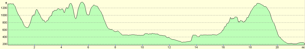
For more information on profiles, ascents and descents, see this page
Accommodation
I spent the night at The Moors Farm, Oswestry Road, Welshpool, Powys, SY21 9JR. They can be contacted on (01938) 553395, or on the web at http://www.moors-farm.com. I can thoroughly recommend this B&B; the room was extremely well appointed, the owner very friendly and we even got a free couple of beers and a drive into Welshpool to get some food. If you have to stay in the area, consider this place first. Camping is also allowed at a cost of five pounds.
Disclaimer
Please note that I take no responsibility for anything that may happen when following these directions. If you intend to follow this route, then please use the relevant maps and check the route out before you go out. As always when walking, use common sense and you should be fine.
If you find any information on any of these routes that is inaccurate, or you wish to add anything, then please email me.
All images on this site are © of the author. Any reproduction, retransmissions, or republication of all or part of any document found on this site is expressly prohibited, unless the author has explicitly granted its prior written consent to so reproduce, retransmit, or republish the material. All other rights reserved.
Although this site includes links providing convenient direct access to other Internet sites, I do not endorse, approve, certify or make warranties or representations as to the accuracy of the information on these sites.
And finally, enjoy your walking!
This walk was mentioned in the following routes:
| Offa's Dyke |
Nearby walks
| # | Title | Walk length (miles) |
|---|---|---|
| 182 | Knighton to Craven Arms | 15.3 |
| 689 | Glyndwr's Way: Knighton to Beacon Lodge | 10.8 |
| 690 | Glyndwr's Way: Beacon Hill to Abbeycwmhir | 22.2 |
|
|

|