Walk #765: Buttington Bridge to Carreg-y-Big
 |
 |
|
General Data
| Date Walked | 06/04/2007 |
| County | Powys, Shropshire |
| Start Location | Buttington Bridge |
| End Location | Carreg-y-Big |
| Start time | 08.45 |
| End time | 18.56 |
| Distance | 21.0 miles |
| Description | This was a walk of two halves; a flat section following the Montgomery Canal and the River Severn was followed by a hilly section with some superb views to the north of Llanymynech. |
| Pack | Today I carried my 80-litre Macpac Glissade rucksack, containing a North Face Blue Kazoo sleeping bag, my North Face Westwind tent, clothes, waterproofs and other camping items, including cooking gear. |
| Condition | I am very tired after this walk, but I have no significant problems aside from stiff legs, which is to be expected after three days of more than twenty miles over tough terrain. |
| Weather | Today was a sunny day with not much cloud in the sky, and only a little wind to help cool me down as I walked. |
| OS map | Landranger number 126 (Shrewsbury & Oswestry) |
 |
 |
|
 |
 |
|
Map of the walk
Maps courtesy of Google Maps. Route for indicative purposes only, and may have been plotted after the walk. Please let me have comments on what you think of this new format. For a detailed table of timings for this walk, please see the table file.
 |
 |
|
 |
 |
|
Notes
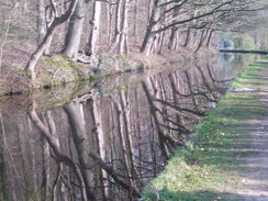
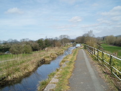
I had a great night's sleep in the B&B, and after watching some television and having another shower I went down for a large and filling breakfast, buffet style that allowed me to grab a little fruit to eat later in the day. For the second day in a row I was unsure how far I wanted to walk, and whilst I waited for Gary to come down I studied the map, looking at all of the alternatives. I said goodbye to the owner of the B&B, whom had been extremely kind in driving us into town the previous night, and set off. The initial stretch of the walk took me northeastwards along the towpath of the Montgomery Canal, a pleasant walk on what looked as though it would be a sunny afternoon, although the noise of the nearby A483 road intruded at times. Gary caught up with me after about a mile, and we walked together towards the lock at Pool Quay.
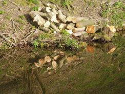
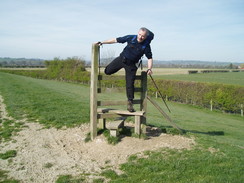
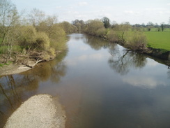
After the extreme climbs of yesterday, the morning's flat walk seemed exceptionally easy and we made good time as we followed the banks of the River Severn, crossing the course of an old railway line before slowly turning to take a more northerly course. Driftwood piled up against fences showed how high the river could get when in flood, although the level was far down the banks today, the difference in height being remarkable. The walk was fairly boring, and we chatted as we walked, including some tomfoolery, including Gary clambering over a stile that stood on the flood bank with no fences or hedges attached to it.
At Upper House I started to walk a little faster, and I agreed to meet up with Gary in the village of Llanymynech for lunch. I accelerated off, soon crossing some large floodgates that were not actually over any water - I assume that they are there to allow floodwaters leave the floodplains in a controlled manner. At Derwas Bridge the trail crossed the New Cut, and afterwards crossed a recently-ploughed field that proved to be quite hard on my legs. The walk after this was a little more varied than it had been along the Severn but there was still little of note; immediately to the south of Four Crosses there were notices for a footpath diversion, but as it was not yet in force I continued along the old route, crossing a series of stiles past a farm.
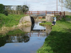
At the other end of the diversion in Four Crosses I went slightly wrong, taking the wrong road and having to walk back along another one to reach the main road through the village. I plodded on northwards along the busy road, which fortunately had a pavement, before diverting off along a quiet lane to rejoin the towpath of the Montgomery Canal. A very pleasant couple of miles followed as the canal wound around to the spectacular aqueduct over the River Vyrnwy, a stone structure that gave some good views down the valley. A little further on were the restored Carreghofa Locks, although they looked fairly decrepit at this point. The reason for this was visible below the bottom lock - a road bridge had been flattened and the canal filled in, and therefore no significant craft can actually reach the locks.
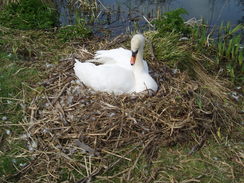
There were a couple of swans nesting along the canal, and in the sunshine it was a highly pleasant walk. Eventually the scene became more urban as back gardens and new housing encroached onto the canal near Llanymynech, and I diverted off the towpath to find a suitable pub. The first had music blaring out, and so I walked on for a few yards and crossed the main road to reach another one that was far quieter. I sat down with my customary two pints, sculling most of the pint of orange and lemonade down in one go - I had been hotter than I had expected during the day. There was no mobile reception in the pub, so I went outside and phoned up a place at Carreg-y-Big, about ten miles and a hard walk away. I also sent a text message to Gary to tell him which pub I was in, and I settled down to continue drinking.
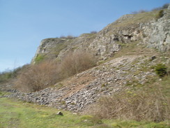
Gary soon arrived, and I bought him a pint as we chatted away. It turned out the place that I had just booked was the same place that he had booked into, although I had been planning to camp for the night. We set off together, and soon we were starting a tough climb up onto Llanymynech Hill. The top of this has been extensively quarried, and the landscape and views are spectacular, with a broad vista available below. The walk through the old quarry seemed to take a long time, but segments of the dyke were visible as we walked along. Eventually the path reached a golf course, and followed the dyke along the edge of this as I reveled in the sunshine.
A steep descent led down to Pen-y-coed, and the gradient leveled off as the trail headed across footpaths to reach a mineral railway, the Tanat Valley line, which still has tracks down despite being last used in 1988, although the rails were still well overgrown. Shortly beyond this we reached a road in Porth-y-waen, and this started to climb uphill, reaching a level crossing at White Gates. The tracks were still down on this line as well, and there were several men walking around clearing the line. They were from the Cambrian Railway Society, and were clearing the stretch of line ready for an eventual reopening. We chatted to the workmen for a few minutes, before continuing our plod along the road as it climbed uphill.
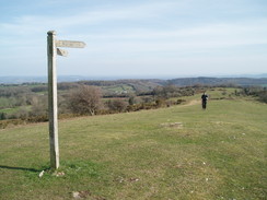
The ascent was gradual but long., but the slight gradient meant that I could keep up with Gary on the ascent, which was followed by a steep descent down to meet a road in a valley. The road headed up for a couple of hundred yards through Nantmawr, after which the path started another steep ascent up onto the hill of Moelydd. It was a stiff climb, initially through trees, but occasional glimpses to my left showed that it could be worth it. A short stretch of open ground followed, and before we knew it we were at the top of the hill, where there was a signpost and superb views in nearly all directions. It was definitely a place to stop and look, and I let the views sink in for a few minutes.
I set off first, following (or so I thought) the fingerpost at the top of the hill whilst Gary stayed at the top. Once I had descended a short distance I could not see the way down, and I started walking around the southwestern flank of the hill for the path down. Gary started looking for the path and could not find it either, and eventually we met up at the northern side of the hill. Neither of us had any idea where the path went, and as I was loathe to climb up to the summit once again we cut across a field northeastwards to reach a track that led us back the short distance to a farm and the trail. This mistake was all my fault, and I was annoyed myself for having made such a silly navigational mistake. No real harm had been caused, however, and as we descended along a road towards Trefonen we stopped to chat for a few minutes to a couple of sectional walkers.
A path led us eastwards into Trefonen, and I walked slightly ahead of Gary, who was strangely delayed, and I waited for him when the path ended at a road. He eventually emerged, and explained that the cows in the field had been crowding around him and preventing him from going where he had wanted to - something that I have had happen to me and can be very annoying. We had planned to stop at the pub in the village, but as we followed the waymarkers along a road a local explained that we had passed it; it was only a short distance away down the hill, but neither of us could face turning back, especially if it would involve yet another climb. Instead we walked on together as the trail headed northwards alongside the dyke.
At one point there was an electric fence blocking the path; this was easy for Gary to clamber under, but proved difficult for me as I had a much larger pack on. A steep descent followed down to Tyn-y-coed, where there was a pub marked in my (old) edition of the guidebook, Naturally this had been converted into a private residence some time ago, and so we walked on. A few yards later there was a cottage with food and drink for sale on a table outside it, and as Gary pressed on up the hill I bought myself a Lion Bar and started on after him.
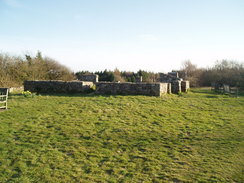
This promised to be the final ascent of the day, but it was steep nonetheless and Gary soon accelerated away from me. The surrounding trees kept the sun off me, and at least I was nice and cool during the long climb. Once the gradient slackened I could look around myself more and examine the stretch of dyke beside the path as I walked, although it continued to climb before eventually flattening out and leaving the trees behind. A short stretch of open land was followed by a broad track through trees, the ground underfoot being covered by wood chippings that felt wonderful under my tired feet. On the other side of this was another clearing, and on the other side of this was a topograph based on the remains of the old Oswestry racecourse grandstand. It was a pleasant spot and was consequently quite busy with people, so we asked people around where the accommodation was, and discovered it was where we expected, about a mile further on.
A long walk followed, initially along a path past the old racecourse before joining a road that headed along Baker's Hill; the dyke itself is a few hundred metres away to the west, but there is no right of way along it; it would certainly make for a better walk than the road. Eventually the stables at Carreg-y-Big became visible, and we both staggered in and booked ourselves in; I had decided to take a room instead of camping, and I was soon having a nice, warm shower. Gary had asked for an evening meal and I decided to join him; this was a delicious green curry, and we were given a complimentary beer with it. We were both shattered and we had finished the walk quite late, so by the time we had finished the meal it had been dark for some time, and so we went upstairs and watched a film - "Austin Powers, the Spy who shagged me". Gary went to bed before the end, but I stayed up for the end, switched off the television and went to my room and immediately fell asleep.
Directions
| The walk is covered in detail in the Offa's Dyke National Trail Guide North (Knighton to Prestatyn), by Ernie and Kathy Kay, and Mark Richards, ISBN 1-84510-976-6 published by Aurum Press Ltd. Click on the image to the right to go to the Amazon page for the book. | 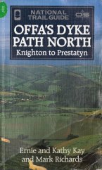 |
Distances
| From | To | Distance (m) | Ascent (ft) | Descent (ft) |
|---|---|---|---|---|
| Buttington Bridge | Four Crosses | 7.6 | 128 | 138 |
| Four Crosses | Llanymynech | 3.0 | 66 | 33 |
| Llanymynech | Trefonen | 6.5 | 1545 | 1175 |
| Trefonen | Carreg-y-Big | 3.9 | 873 | 482 |
This makes a total distance of 21.0 miles, with 2612 feet of ascent and 1828 feet of descent.
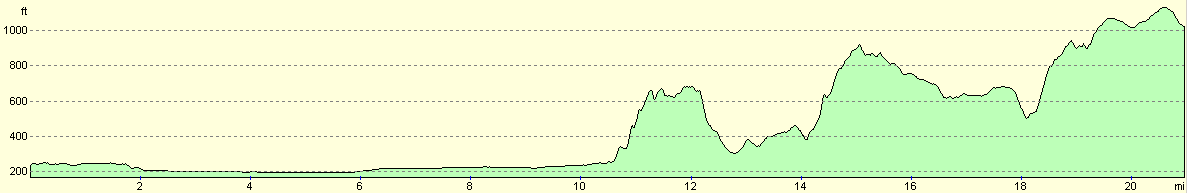
For more information on profiles, ascents and descents, see this page
Accommodation
I spent the night at Careg y Big, Selattyn, Oswestry, Shropshire SY10 7HX. They can be contacted on ((01691) 654754, or on the web at http://www.carreg-y-big.co.uk. This was a mixture of hostel and B&B, with reasonable rooms that smelt a little horsey (which is to be expected, as there are stables at the farm). Camping is also allowed at the farm. However, it was rather pricey for what we got, and it would probably have been better if I had just camped.
Disclaimer
Please note that I take no responsibility for anything that may happen when following these directions. If you intend to follow this route, then please use the relevant maps and check the route out before you go out. As always when walking, use common sense and you should be fine.
If you find any information on any of these routes that is inaccurate, or you wish to add anything, then please email me.
All images on this site are © of the author. Any reproduction, retransmissions, or republication of all or part of any document found on this site is expressly prohibited, unless the author has explicitly granted its prior written consent to so reproduce, retransmit, or republish the material. All other rights reserved.
Although this site includes links providing convenient direct access to other Internet sites, I do not endorse, approve, certify or make warranties or representations as to the accuracy of the information on these sites.
And finally, enjoy your walking!
This walk was mentioned in the following routes:
| Offa's Dyke |
Nearby walks
| # | Title | Walk length (miles) |
|---|---|---|
| 745 | Glyndwr's Way: Dolanog to Welshpool | 19.7 |
| 746 | Welshpool to Newtown | 14.7 |
| 764 | Spoad Hill to Buttington Bridge | 21.7 |
|
|

|