Walk #763: Kington to Spoad Hill
 |
 |
|
General Data
| Date Walked | 04/04/2007 |
| County | Powys, Shropshire, Herefordshire |
| Start Location | Kington |
| End Location | Spoad Hill |
| Start time | 08.27 |
| End time | 19.03 |
| Distance | 20.4 miles |
| Description | This was a long and grueling walk that followed OFfa's Dyke northwards to Knighton and then over half of the Switchback, with some superb views to be had over the surrounding plains and hills, and the dyke itself, in places. |
| Pack | Today I carried my 80-litre Macpac Glissade rucksack, containing a North Face Blue Kazoo sleeping bag, my North Face Westwind tent, clothes, waterproofs and other camping items, including cooking gear. |
| Condition | I am very fatigued after this walk, but this is only to be expected after such a strenuous walk. |
| Weather | The morning started off cloudy, but as the day drew on the clouds disappeared and was replaced with bright sunshine. There was still a stiff breeze that was chilly when I was exposed to it. |
| OS map | Landranger number 148 (Presteigne & Hay-on-Wye area) and Landranger number 137 (Ludlow & Church Stretton, Wenlock Edge) |
 |
 |
|
 |
 |
|
Map of the walk
Maps courtesy of Google Maps. Route for indicative purposes only, and may have been plotted after the walk. Please let me have comments on what you think of this new format. For a detailed table of timings for this walk, please see the table file.
 |
 |
|
 |
 |
|
Notes
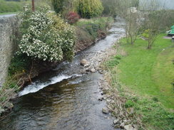
I awoke early after another good night's sleep and so I watched television until the breakfast, which had been arranged for 07.30 in the morning. My tent, which I had hung up in the shower to dry overnight, was quickly packed up and after a lovely, filling breakfast I shouldered my rucksack and headed off into a Kington that scarcely appeared to have woken up. Initially the trail descended down by some pretty houses to cross a stream and the A44, before climbing up steeply, along a road and paths to reach Kington Golf Course, apparently the highest 18-hole course in England.
At the golf course I passed a couple of houses, and a man walking a dog stopped for a chat. He used to run a B&B by the course, and told me a story about a woman of 47 a few years before who had walked all the way from Hay-on-Wye, intending to stop in Kington but missing the town and continuing on all of the way to Knighton! That would have been a long walk, but apparently it is easy to take an incorrect route off the Hergest Ridge and miss the town.
As I continued along the trail past the golf course and across fields I started thinking about what I was going to do about accommodation for the night, The obvious place to stop was Knighton, but the possibility of going further loomed heavily in my mind. I was therefore keen to get to Knighton as quickly as possible, so that I would have the possibility of extending the walk if I felt up to it.
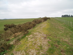
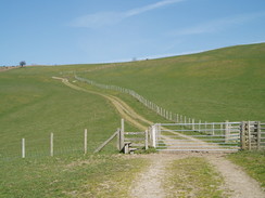
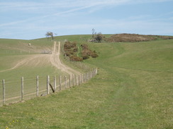
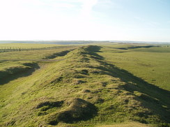
On Rushock Hill the trail rejoined the course of Offa's Dyke for the first time in days, and the ditch and bank, although heavily eroded and little more than a small mound, were a very pleasant and welcome sight. The path followed the dyke and in places I walked along the top of it and admired the good views, before dropping down past the flank of Herrock Hill to reach a road in Lower Harpton.
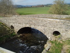
The road was not too busy and this was a good thing as there were some sharp bends and the verges were narrow, but I reached Ditchyeld Bridge in good time. The road now goes over a new bridge, but beside it is a lovely single-lane old arch bridge, which has two circular flood relief holes through the abutments on either side of the arch. The day was glorious, and although the wind was still blowing the clouds overhead were far more broken than they had been yesterday.
The path followed a road for a short distance before climbing up along the edge of some woodland to reach Old Burfa, an ancient building that was shrouded in scaffolding. Shortly afterwards another road was crossed, and then the path started to climb uphill, following exactly the course of the dyke, with the ditch in this location being the course of the stream.
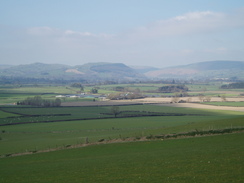
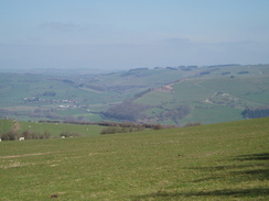
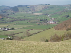
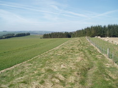
There were many stiles that needed to be crossed on this stretch, and on one of these I gave my left knee a hefty knock that caused it to worryingly ache for the rest of the day. The views over the Radnor Valley to the west were superb and helped take my mind off the views, but after the trail joined a track through Granner Wood I was faced with a hefty climb up onto the top of Hilltop Plantation that caused it to hurt considerably.
A long descent followed the course of the dyke downhill with superb view straight ahead, although the view also showed me another big climb ahead. In places the dyke was quite low and in others significantly larger, and in the latter places it looked like it could actually have been a defensive structure.
As I neared the road at the bottom I noticed a walker with a light pack approaching from behind. Once across the road we started chatting; he was a postman from Knighton who was doing a quick day-walk over the hills from Kington back to his home. It was really pleasant having someone to chat to once again, and we talked about the walk and the local area; he made being a postman seem like quite an attractive vocation.
We chatted as the trail crossed an attractive river at Dolley Old Bridge and ascended slightly to meet a main road at Dolley Green. Here the ascent got steeper as the trail headed uphill along a track, and I said goodbye to the postman as he accelerated up the hill; I was weighted down with my pack and could only watch as he rapidly vanished ahead of me.
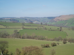
The track curved around onto Furrow Hill, and as it did so I got a glimpse of him ahead of me, still going strongly as the path climbed. There was no way that I could even hope of keeping up with him, and so I plodded on, and once the gradient slackened stopped at a place that had some superb 180-degree views westwards over the hills. It was a great place for a stop, and I let them sink in whilst munching on a handy chocolate bar, sheltered from the wind by the flanks of the hill. A Tornado flew magnificently directly overhead, and I could watch it disappear into the distance for about half a minute.
I only allowed myself a relatively brief stop, and I was soon toiling uphill once more, reaching the summit of Hawthorn Hill before leveling out and heading towards an obelisk a monument to Sir Richard Green Price in the distance. The path did not directly visit the obelisk and instead continued alongside the dyke for a short distance, passing a lovely area of gorse before reaching a road.
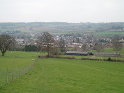
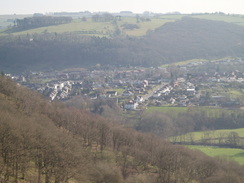
Another short stretch of path beside the dyke followed before the trail rejoined the road downhill. This fortunately did not last too long, and soon I was heading along footpaths once again as the trail plunged downhill and climbed in company with the dyke, which was magnificent in places, and looked somewhat like the Devil's Dyke near where I live in Cambridge. A long and sometimes steep descent followed, the descent getting increasingly steep as it neared Knighton and entered the Great Frydd Wood. It was a relief when the gradient slackened and a road was reached, after which I plodded on downhill right into the centre of the town.
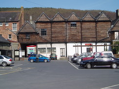
It was still the early afternoon and there was plenty of daylight left, and so I passed the clock tower and plodded along the road to the Offa's Dyke Centre. I had a quick look around this, but there was little that caught my interest aside from the accommodation book and campsite listing, which I purchased. To be honest I was not really in the mood to look at the exhibition, and in a restless state I left and headed back along the road towards the centre of the town. Knighton marked the end of the first of the two guidebooks on the trail, and I went into the post office to post the first of these back to Cambridge. Finishing a guidebook is always a big moment on a trip, and afterwards I went into a nearby pub for a drink.
The pub was nearly empty but the barmaid was friendly, and I had a couple of pints (as usual, one of alcohol and the other of orange and lemonade) as I looked at the accommodation lists and wondered about what I would do for the rest of the afternoon. It would be easy to stop for the rest of the day in Knighton, but the next stretch of the path to Brompton Crossroads is the hardest of the entire trail (indeed, it is informally known as 'The Switchback' due to the nature of the terrain), and as I was still feeling relatively fit I decided to press on.
The newly-purchased camping list told me that there was a campsite on Spoad Hill, which was a little under seven miles away, and I felt like that might be a good place to stop for the night, knowing that if I got too tired or ran out of time I could just put my tent up somewhere. Before I set off I took my coat off (which I had used to shelter me from the wind) and put a knee brace onto my left knee.
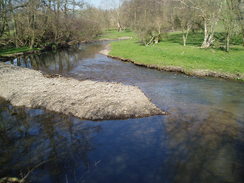
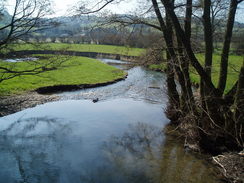
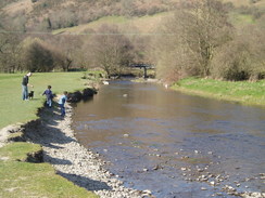
The walk through Knighton was easy enough, and the trail crossed a little recreation ground before winding around past a series of memorial stones, including one that commemorated the opening of the trail, before dropping down to meet the south bank of the river. By this time it was quite a warm day and there were lots of people enjoying being by the river, and after a few minutes I met a woman pushing a pram who asked me if I was walking the trail. When I replied yes, she told me that there was another man a few minutes ahead of me who was also walking the path, and I decided to see if I could catch up with him.
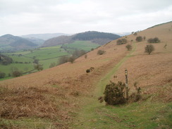
The trail crossed the river on a footbridge beside the railway line, and after carefully crossing the line I was greeted with a really steep climb up onto Panpunton Hill. Initially this skirted the western edge of Kinsley Wood, but then headed off northwestwards away from the trees, still climbing stiffly. Ahead of me I could see another walker with a small pack, and I knew that it was the other trail walker. However, although he only seemed a couple of hundred yards ahead of me it was a steep climb, and he soon disappeared over the top whilst I was still toiling my way up.
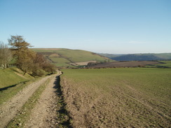
Once the gradient slackened near another band of trees I went slightly wrong and followed a more-or-less level track for about fifty yards; I soon realised my mistake and instead headed back to resume a climb up a slope that was thankfully less steep than the one I had just toiled up. From here there were some superb views to the west, and I could clearly make out the first few miles of Glyndwr's Way, which starts in Knighton, as it climbed up Garth Hill. Eventually the top of the climb was reached near a seat without a back and the gradient slackened, leaving a breezy but enjoyable stroll northwestwards across fields; all the time I could see the other walker ahead of me, seemingly at the exit to every field as I entered it.
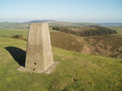
A little descent down followed as the path skirted around the edge of a little valley, before climbing steeply up to reach a trig pillar on Cwm-sanaham Hill. I passed a couple of other walkers walking the stretch of the trail south from Welshpool; they were making for Knighton overnight and were glad to hear that they only had about an hour to go. The views from the trig pillar were superb but slightly disheartening; I could see a series of climbs that I would have to do before the day was over.
I started the first descent quickly enough, but I soon slowed down as it got steeper, but eventually I wound myself passing a pretty whitewashed cottage at Brynorgan and continuing to fall to a road. A steep ascent followed, but fortunately this did not last too long and I was soon descending once again to cross a stream via a footbridge (engraved with "Built by Royal Engineers 1985") near Garbett Hall. Here I finally met up with the gentleman ahead of me, and we started chatting as a long track took us uphill.
His name was Gary, and he had set off from Chepstow at midday on Saturday, an hour after me, and had spent the first night at Redbrook. As he only had ten days in which to walk the path he was setting himself a punishing pace, and he kept this up as we continued uphill together. His pack was far lighter than mine and I was pleased that I could manage to keep up,and we chatted as the trail passed an absolutely superb stretch of the dyke, heading northwestwards onto Llanfair Hill with very few rises or falls to contend with. It was great having someone to chat to,and the tiredness in my feet seemed to disappear as we walked on along some great scenery.
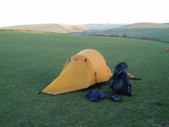
Eventually a road was reached and we followed this as it descended slightly before climbing up to reach Springhill Farm on Spoad Hill, where I had managed to book myself in for a night to sleep. Gary was continuing on for another mile down to the village of Newcastle, and so we swapped mobile phone numbers as we parted, hoping that we may meet up again on the trail. The campsite was literally a field beside the farm, the low grass being freshly cropped by sheep, and I quickly got my tent up in the little remaining daylight before using the facilities in an outbuilding. It was a pleasant enough spot to spend a night, but I was shattered after having walked around twenty miles over rough terrain, and I soon dropped off to sleep.
 |
 |
|
 |
 |
|
Directions
| The walk is covered in detail in the Offa's Dyke National Trail Guide South (Chepstow to Knighton), by Ernie and Kathy Kay, and Mark Richards, ISBN 1-84513-274-2 published by Aurum Press Ltd. Click on the image to the right to go to the Amazon page for the book. | 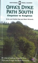 | The walk is covered in detail in the Offa's Dyke National Trail Guide North (Knighton to Prestatyn), by Ernie and Kathy Kay, and Mark Richards, ISBN 1-84510-976-6 published by Aurum Press Ltd. Click on the image to the right to go to the Amazon page for the book. | 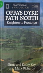 |
Distances
| From | To | Distance (m) | Ascent (ft) | Descent (ft) |
|---|---|---|---|---|
| Kington | Dolley Green | 8.0 | 1637 | 1608 |
| Dolley Green | Knighton | 5.4 | 955 | 912 |
| Knighton | Spoad Hill | 7.0 | 1870 | 1171 |
This makes a total distance of 20.4 miles, with 4462 feet of ascent and 3691 feet of descent.
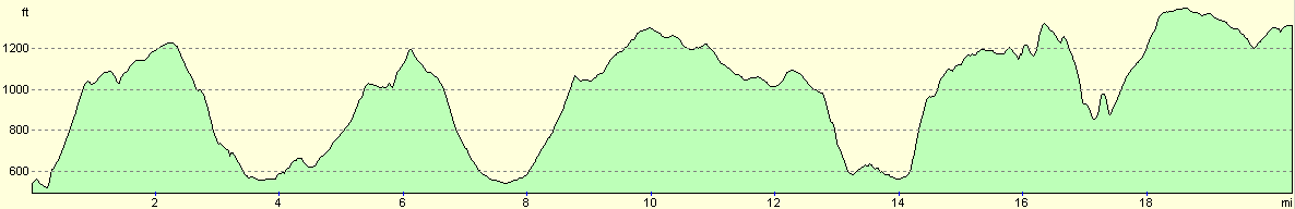
For more information on profiles, ascents and descents, see this page
Accommodation
I spent the night in my tent at Springhill Farm,Newcastle-on-Clun, Craven Arms, Shropshire SY7 8PE. They can be contacted on (01588) 640350. This was a pleasant enough place to camp, and it was also cheap although the facilities were spartan (showers were extra). From where I pitched my tent there were some good views southwards towards Offa's Dyke. The owners also do B&B.
 |
 |
|
 |
 |
|
 |
 |
|
 |
 |
|
 |
Disclaimer
Please note that I take no responsibility for anything that may happen when following these directions. If you intend to follow this route, then please use the relevant maps and check the route out before you go out. As always when walking, use common sense and you should be fine.
If you find any information on any of these routes that is inaccurate, or you wish to add anything, then please email me.
All images on this site are © of the author. Any reproduction, retransmissions, or republication of all or part of any document found on this site is expressly prohibited, unless the author has explicitly granted its prior written consent to so reproduce, retransmit, or republish the material. All other rights reserved.
Although this site includes links providing convenient direct access to other Internet sites, I do not endorse, approve, certify or make warranties or representations as to the accuracy of the information on these sites.
And finally, enjoy your walking!
This walk was mentioned in the following routes:
| Offa's Dyke |
Nearby walks
| # | Title | Walk length (miles) |
|---|---|---|
| 182 | Knighton to Craven Arms | 15.3 |
| 689 | Glyndwr's Way: Knighton to Beacon Lodge | 10.8 |
| 690 | Glyndwr's Way: Beacon Hill to Abbeycwmhir | 22.2 |
|
|

|