Walk #826: A circular walk from Easton to Shawford via Winchester
 |
 |
|
General Data
| Date Walked | 15/01/2009 |
| County | Hampshire |
| Start Location | Easton |
| End Location | Easton |
| Start time | 08.10 |
| End time | 14.56 |
| Distance | 18.0 miles |
| Description | This was an enjoyable walk, following the Itchen Way southwards, then taking a roundabout route back over the Twyford Down to Winchester |
| Pack | Today I carried my 30-litre Karrimor rucksack, filled with waterproofs, a flask and other odds and ends. |
| Condition | My feet are in a better condition than they were after the last walk, but I still have a couple of small blisters on my little toes - the curse of new boots. The worst problem was that I slightly twisted my left ankle during the walk, which bothered me for the rest of the day. |
| Weather | Today was a grey day, and the sun scarcely made an appearance. It was much warmer than it has been, however. |
| OS map | Landranger number 185 (Winchester & Basingstoke, Andover & Romsey) |
 |
 |
|
 |
 |
|
General Walk Information
| Leg | To | Time | Grid reference |
|---|---|---|---|
| 1 | Easton | 08.10 | SU5135932130 |
| 2 | Footpath | 08.20 | SU5157732676 |
| 3 | Bridge under M3 | 08.38 | SU5038332552 |
| 4 | Bridge under A34 | 09.04 | SU4940331486 |
| 5 | Footpath | 09.20 | SU4911730333 |
| 6 | City Mill, Winchester | 09.36 | SU4860529300 |
| 7 | Tun Bridge | 09.56 | SU4837228067 |
| 8 | Path under old rail bridge | 10.13 | SU4800626975 |
| 9 | Towpath of Itchen Navigation | 10.30 | SU4770925912 |
| 10 | Road in Shawford | 10.46 | SU4734824941 |
| 11 | Bench by road in Twyford | 11.00 to 11.15 | SU4810524574 |
| 12 | Track junction | 11.33 | SU4936324738 |
| 13 | Bridleway / road junction | 11.50 | SU5059824389 |
| 14 | Road junction | 12.03 | SU5032625283 |
| 15 | Track crossing | 12.25 | SU4956726728 |
| 16 | Track / road junction | 12.39 | SU5020427413 |
| 17 | Footbridge over M3 | 13.00 | SU4894427665 |
| 18 | City Mill, Winchester | 13.25 | SU4859729300 |
| 19 | Footpath | 13.45 | SU4920530564 |
| 20 | Bridge under A34 | 13.59 | SU4938631480 |
| 21 | Bridge under M3 | 14.26 | SU5036632559 |
| 22 | Footpath | 14.44 | SU5158232667 |
| 23 | Easton | 14.56 | SU5135932130 |
 |
 |
|
 |
 |
|
Notes
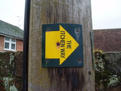
Today did not dawn well; there was heavy cloud overhead, and the weather forecast was for light rain. However, it was warmer than it had been for some time, and so I decided to risk a walk. My last walk had been based around the start of the Itchen Way; there was only a four-mile gap to be closed from Easton to Winchester to complete the trail. Instead of jut walking this stretch, I decided to extend the walk by following the Itchen Way further south from Winchester.
The drive up to Easton was troublesome with traffic stop-start on the M3, but fortunately I had set off in plenty of time, and it had really only just got light by the time I found a place to park on a roadside near a pub in the village. Initially I followed a road out of Easton, following a route that I did on the last walk, but soon I joined a path that cut across fields to reach a couple of footbridges over the River Itchen. Another footpath followed, again following part of the last walk, taking me westwards towards Easton Bridge.
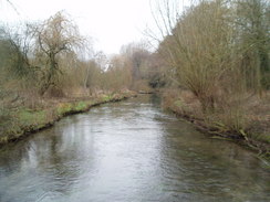
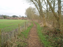
From here the Itchen Way took me westwards across flat fields. The noise of the M3 grew increasingly intrusive, and then the path junked to pass under the motorway in a long concrete culvert. The path led up to a road, and then cut across a very scrubby piece of land to cross the river once more. Unlike the last walk, when the weather was foggy, today was dry, and I got some superb views over the river. Again the noise from the M3 was intrusive as the path headed between the river and Easton Down, so I turned up the volume on my Walkman and plodded on.
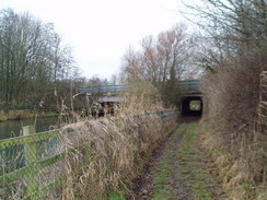
The path passed under the A34(T) on metal platforms built over the river; in floods thus will certainly be impassable. Immediately beyond this the path skirted the side of an embankment of the old Didcot, Newbury and Southampton Railway, closed in 1965. Indisutrial units soon started on the bank to me left, and I turned the volume up once more as I followed the path southwards.
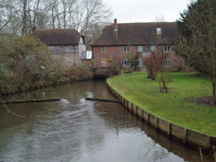
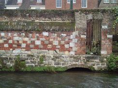
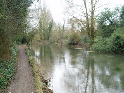
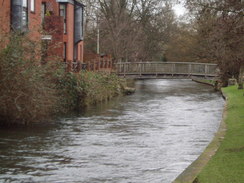
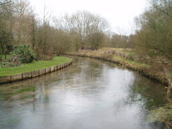
On a road in the Winnall part of Winchester I saw a policeman with a radar camera; after asking him if I was walking slowly enough (a question he thankfully saw the funny side of), I joined a quieter road that led southwards. This was a very attractive, short stretch, with the river on my right. A couple of wooden bridges led over the water, and led me to the City Mill, a medieval water-powered mill. This also marks the start of the South Downs Way National Trail.
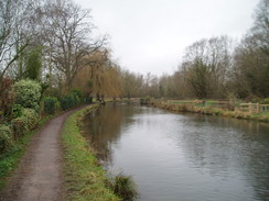
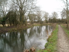
This was followed for a short distance southwards along what is a superb stretch of river towards another mill and the youth hostel. There are a couple of plaques giving information about the river; for instance, at this point it was once double its current width, and the current channel is actually man-made. From here a road took me on for a short distance, and then the Itchen Way continued along the course of the old Ithen Navigation from Southampton to Winchester, which opened in 1710 and closed in the mid-nineteenth Century.
I had walked all of this before on a previous walk, but I still enjoyed this stroll, even if the weather was nowhere near as good as it had been on that previous occasion. The path passed Tun Bridge, then skirted below the flanks of St Catherine's Hill, which has an Iron-age hillfort at its summit, along with the site of an 12th Century chapel. I resisted the temptation to climb this, and instead plodded on. Here the path is in conjunction with the old railway line once more, and also a wide area of grassland. At first I thought that this was part of an old railway; instead, it was the old Winchester Bypass, opened in the 1920's and one of the earliest dual carriageways in the country. When the M3 over Twyford Down was completed in the mid-nineties, the old road was covered with spoil and used to replace some of the SSSI lost in the construction of the M3.
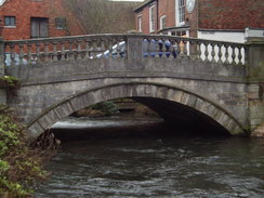
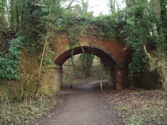
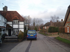
The path passed under an old railway bridge and reached a road near the M3. It passed under the M3, then rejoined the side of the river. The next stretch south to Shawford would have been much more pleasurable in the sunshine, but it was not bad even in the gloom. As I appraoched Shawford I had a decision to make; I had only gone about seven miles, but it was my plan to walk much further. I had intended to walk further south along then canal, and then walk back the way I had come. However, a quick study of the map showed me another alternative looping route to the east; I decided to do this instead. In Shawford I joined the road and followed it east to Twyford. I stopped here on a bench next to a garland of poppies as I ate my lunch. It was not the best spot for a break, but it was not the worst, either.
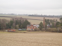
I was still hungry, so I nipped into the little post office opposite to get some snacks before continuing on along the road. This stretch follows the Monarch's Way, a long-distance walk that I want to do sometime. It followed a road for a short distance, then joined a series of tracks eastwards. It passed above the lovely brick buildings of the Edwardian Twyford Pumping Station, which is dominated by a tall brick-built chimney.
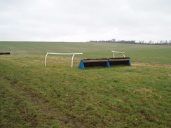
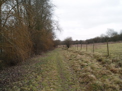
I left the Monarch's Way when it met Mare Lane, and I followed this road northwards. Not a single car passed me on this stretch, and the lane was sunken sown into the chalk. The exposed chalk banks made it look as though the tarmac had been laid straight down onto the chalk. A bridleway then took me northwestwards across Hazeley Down. This rose and fell as it went, and after a while the surface became heavily churned up by horses' hooves. Off to the right were some professional-looking horse jumps, and this whole area looks as though it is frequently used for training horses.
It had been my plan to head northeastwards from here towards the village of Chilcomb, but I found my path was blocked by a red flag, showing that the shooting range below was in use. This meant that the long climb I had just made was pointless, and I was forced to head back down into Winchester. Fortunately there was a footpath that skirted the road, which meant that I could avoid the traffic, and there were some good views to be had to the north. I rejoined the same track that I had been on, the one that led across Hazeley Down, and headed to a footbridge over the M3. Unfrotuantely on the last stretch of the descent I went over on my left ankle, twisting it slightly. I picked myself up and tested the ankle; it could take my weight, but was painful. Happy that it was not too bad a twist, I plodded on across the bridge and started the walk northwards into Winchester.
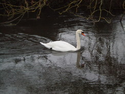
Near the Park and Ride in Bar end I saw a couple of deer in the cutting down to my right, between the road and motorway. It was a pleasant sight, especially considering that the piece of land used to be the Winchester bypass! A long road walk led me back to City mill, and there I rejoined the route I had been following earlier in the day, walking northwards along the Itchen Way. I limped on, my ankle complaining whenever it twisted on rough ground. I resisted the temptation of entering the pubs I passed on the way, if only because I was afraid that if I stopped my ankle would not allow me to continue on.
As I passed under the A34(T) bridges once more I tried to find any trace of the old railway bridge that must have crossed the river; the only thing I could find was the remains of the embankment on the northern side of the river, jammed in between the two roads. I limped on, and was relieved when the car finally came into sight. I was tempted to extend the walk slightly, to make it a 20-mile day, but there was no way that my ankle would allow me to do this.
It had been a reasonable day's walk, although I doubt that in any way that this is the best stretch of the Itchen Way. It is too close too both the M3 and A34, and although the stretch south from Winchester to Shawford can be very attractive, the stretch from Easton to Winchester is not.
 |
 |
|
 |
 |
|
Directions
This walk starts off at 'The Chestnut Horse' pub in Easton. Leave the pub and turn left, following the road as it heads north. After a short distance it swings to the right; follow it eastwards for a hundred yards, and then, just before a house, turn left along a gravel driveway that carries a footpath. When the driveway ends, continue on along the footpath. This turns to the right and then the left, keeping a field boundary on the left, until it reaches a stile that leads to footbridges over the River Itchen.
On the northern side of the river the end of a road is reached in Martyr Worthy. Walk up this road for a few yards, and then turn left to climb up a bank that carries a footpath. This skirts the garden of the white house, turning left to descend down to near the riverbank, then right to parallel the river. Cross a series of fields for about a third of a mile until Easton Lane is reached. Cross the lane, and then continue westwards along a footpath on the other side for about half a mile; soon this crosses a stile and continues with a hedge on the left.
When the footpath reaches the embankment of the M3 motorway, turn left to cross a stile. The path heads south between hedges for a short distance, before turning to the right and joining a track that heads westwards under the M3. On the other side, continue along the faint track as it follows a hedge on the left, climbing up to reach the B3047 road. Turn left along the B3047 road and pass the twin gates of a large house on the left, then turn left down a footpath that heads diagonally across a scrubby field. This passes an old barn on the right before reaching a road. Turn left down this road, and follow it as it crosses the river. Continue on along this footpath as it crosses a patch of land between two tributaries of the river to eventually reach another footbridge. Cross this, and on the other side walk up a gravelled driveway of a large house on the left to reach the end of a road.
Here turn right, and start following a footpath that heads southwestwards for half a mile, skirting between the river on the right and the rise of Easton Down and the M3 on the left. When this reaches the A34(T), it heads down to pass under the bridge over the river using metal platforms built into the river. Immediately after this, the path turns to the left to start heading southwards, with the river a short distance away on the right, and an embankment of an old railway line on the left. This passes through an area of scrubby woodland as industrial buildings appear at the top of the bank on the left; soon it breaks out of the trees and cuts across a couple of open, scrubby fields.
A track is then reached, which leads down to a road in Winnall opposite a car garage. Turn right and started following this road southwestwards. As it reaches a right-hand bend which takes the road over the rover, turn left down another road. This heads southwards with the river in close company on the right; it ends at a road in Winchester by the side of City Mill.
When City Mill is reached by the bridge over the River Itchen turn right along a footpath that runs alongside the river. At a mill building turn left for a few yards to join a road, then turn right along Wharf Hill Road. At the end of this turn left to head south along Domum Road. Near the end of this road, turn right to join the eastern bank to the Itchen Navigation.
Follow a footpath that runs south along the bank of the navigation. This crosses a road at Tun Bridge, then skirts beneath the mass of St Catherine's Hill. The path passes under an old railway bridge, then ends at a road. Turn left to pass under the M3, then head south along the B3335 road for a short distance before turning right down another footpath.
This leads back to the eastern bank of the Itchen Navigation. Follow this southwards for a mile to a road in Shawford; at the road, turn left and start following it eastwards into Twyford. Shortly after it crosses the River Itchen follow the road as it swings to the left to continue eastwards to end at a main road opposite the post office in the village. Cross the road, and on the other side continue on eastwards along another road for a little under half a mile. Just before some houses start on the right, turn right up another road. This climbs uphill, and when a green lane (Love Lane) comes in from the right, turn left to walk eastwards along a footpath.
This heads immediately to the south of Twyford Pumping Station; cross a field boundary and continue on to a hedge. A stile leads onto a track; turn right and follow this track for three-quarters of a mile until it reaches Mare Lane. Here turn left, and follow Mare Lane as it heads downhill to the north. After another three-quarters of a mile this ends at Hazeley Road. Turn right, then after a few yards turn left along a bridleway. This heads northwestwards up Hazeley Down, soon joining a track.
After a mile a junction with another track is reached at the bottom of a hill. Turn right, and follow this track as it heads uphill for half a mile until it ends at a road on Deacon Hill. Alternatively, continue straight on for a more straightforward route to reach the bridge over the M3. Just before the road turn left, and take a footpath that remains in the field as it skirts the edge of the road. Cross the first field boundary, and when a little unploughed area is reached, follow the fence towards the northwestern corner of the field. When this is reached, cross the fence to rejoin the track.
Follow the track as it heads down towards the M3. When the bridge is reached, turn left and cross it. On the other, western, side of the M3, turn right and follow a footpath that heads north alongside the M3, before it curves away slightly to the left before ending at a road near a park and ride. Turn right along this road for a few yards until it reaches a roundabout near Junction 10 of the M3.
Take the first road off to the left, the B3330, and follow it as it heads northwards through the southern outskirts of Winchester before it eventually reaches City Mill. From here, it is simply a case of retracing the steps taken earlier in the day, walking the four miles back to Easton.
 |
 |
|
 |
 |
|
Distances
| From | To | Distance (m) | Ascent (ft) | Descent (ft) |
|---|---|---|---|---|
| Easton | Shawford | 7.2 | 305 | 367 |
| Shawford | Easton | 10.8 | 827 | 764 |
This makes a total distance of 18.0 miles, with 1132 feet of ascent and 1131 feet of descent.
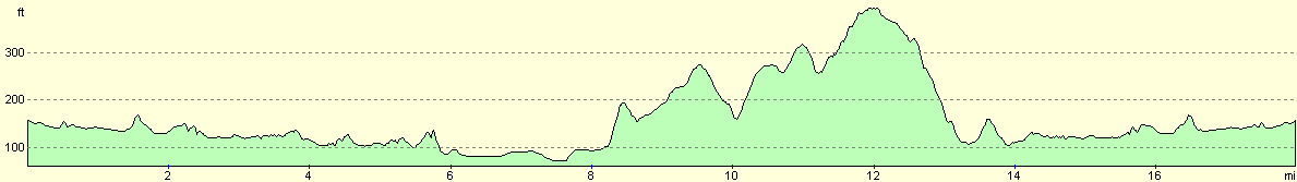
For more information on profiles, ascents and descents, see this page
Disclaimer
Please note that I take no responsibility for anything that may happen when following these directions. If you intend to follow this route, then please use the relevant maps and check the route out before you go out. As always when walking, use common sense and you should be fine.
If you find any information on any of these routes that is inaccurate, or you wish to add anything, then please email me.
All images on this site are © of the author. Any reproduction, retransmissions, or republication of all or part of any document found on this site is expressly prohibited, unless the author has explicitly granted its prior written consent to so reproduce, retransmit, or republish the material. All other rights reserved.
Although this site includes links providing convenient direct access to other Internet sites, I do not endorse, approve, certify or make warranties or representations as to the accuracy of the information on these sites.
And finally, enjoy your walking!
Nearby walks
| # | Title | Walk length (miles) |
|---|---|---|
| 709 | South Downs Way: Winchester to Wether Down | 20.4 |
| 787 | Romsey to Eastleigh via Winchester | 21.1 |
| 812 | A circular walk from North Waltham | 22.9 |
|
|

|