Walk #709: South Downs Way: Winchester to Wether Down
 |
 |
|
General Data
| Date Walked | 28/01/2006 |
| County | Hampshire |
| Start Location | Winchester station |
| End Location | Wether Down |
| Start time | 09.01 |
| End time | 16.37 |
| Distance | 20.4 miles |
| Description | This was a long walk along the western section of the South Downs Way, following it eastwards from Winchester. |
| Pack | Today I carried my 70-litre Craghoppers containing a light load of spare clothes, waterproofs, a couple of books and food. |
| Condition | My knees were generally okay on this walk, which was a relief. My right one ached on the last ascent, but this was not too serious. I was very fatigued at the end of the day, but that is probably to be expected after the really start and the strenuous walk. |
| Weather | Today was bright and sunny with scant cloud, although there was a bitterly chilly wind. |
| OS map | Landranger number 185 (Winchester & Basingstoke, Andover & Romsey) |
 |
 |
|
 |
 |
|
Map of the walk
Maps courtesy of Google Maps. Route for indicative purposes only, and may have been plotted after the walk. Please let me have comments on what you think of this new format. For a detailed table of timings for this walk, please see the table file.
 |
Notes
Part of my plans for the year was to do the South Downs Way, and as I have five days of holiday to use before the end of March I decided to take an extended weekend off and do half of the walk. Due to the short daylight hours at this time of the year I knew that I would have to have a relatively early start in order to be able to do the twenty miles that I wanted to do on the first day and I therefore found myself getting up at a quarter to five in order to catch the first morning train into London. The trip down went well, and although the circle line was shut for maintenance work I still managed to get to Paddington earlier than I expected, and thus an earlier train to Reading. A couple of other changes, at Reading and Basingstoke followed, and although the latter was very tight I managed to get to Winchester station half an hour earlier than I had been expecting.
I left the station and stood in the forecourt outside, bleary eyed and tired, glad to see bright blue skies overhead. A few stretches took the tightness out of my legs, and I then start heading through the city towards the start of the South Downs Way at the City Mill. I had been to Winchester before when I was eighteen but I could not remember much about it aside from the Cathedral, so I was pleasantly surprised as I found that the city is beautiful. I walked slowly and studied the buildings as I passed, and when I passed a bakers shop I nipped in and bought myself two sausage rolls for breakfast. I munched these as I strolled slowly down the High Street, taking my time to study the surroundings.
After a while I saw a sign for the cathedral, and so I diverted off to have a quick look at it. I was aware that I did not have a lot of time, and so I nipped off the High Street just to have a quick look at the magnificent building. One of my few memories of the cathedral from my previous visit is that of Wailliam Walker, a diver who almost single-handedly saved the Cathedral between 1906 and 1912 by underpinning the medieval beech log foundations. After looking at the cathedral I headed back to the High Street, and on the way nipped into a fantastically plush set of public toilets, the cleanest and nicestt that I have been into for years.
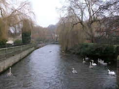
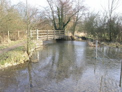
Aware that I could easily spend hours looking around Winchester I decided to press on, passing a statue of Arthur, king of the West Saxons before reaching the City Mill, officially the start of the national trail. I tried munching one of the sausage rolls, but it tasted so horrible that I binned both of them and hence started the walk with no breakfast in me. The initial stretch of the walk followed the River Itchen southwards towards Segrim's Mill, and was a pleasant stroll with lots to see. It then headed off uphill, slowly becoming more residential until eventually a footbridge over the M3 2was reached. As usual with motorways I could hear it before I could see it, but once across the Way headed straight away from it, and the noise quickly receded.
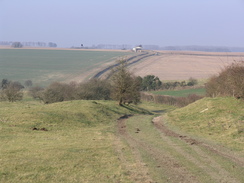
The Way headed eastwards towards the small village of Chilcomb, and it was on this stretch that I encountered the major weather feature of the day, a chilling, biting wind that almost took my breath away whenever I was exposed to it. The ground was frozen underfoot, and although this made the surface hard it also meant that it was far less muddy than it would otherwise have been, Chilcomb came and went without much of interest, and a steep climb took me up onto a hillside at Little Golders. A long stretch of path followed towards a car park on the A272 near Cheesefoot Head, and although the walk was enjoyable the wind spoilt it somewhat, and I started to wish that I had taken my balaclava with me as well as my hat.
After crossing the A272 the way headed along a fairly nondescript section of bridleway along Temple Valley, the only thing of note being a tank I saw hidden in the trees off to the left near Keeper's Cottage. The next stretch of path southeastwards along King's Way back to the A272 was more enjoyable, and the good surface underfoot allowed me to keep good time as I admired the views. Despite only having walked a few miles I was already thoroughly enjoying the South Downs Way, and I hoped that it would continue in a similar manner. After crossing the A272 a combination of roads and tracks took me south to the Milbury's Inn, and although it was tempting to go inside for a drink I still had a long way to go, and I wanted to get more miles under my belt before stopping.
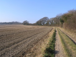
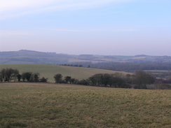
There were some good views to be had as the path headed in an east / southeasterly direction, and although it initially ran along the road there was soon a dedicated footpath running alongside the road. It headed on to Lomer Farm and then on towards Beaconhill Breaches. Here the bridleway and footpath sections split, as the stretch of path through Exton is not yet a bridleway, and the latter has to make a large, sweeping diversion to the north, I could not be bothered to visit the nearby trig pillar, and instead I headed on down a steep path that had some wonderful views to the northeast. The path was initially quite steep and I had to take care with my footing, but once it eased I could admire the views once more until I entered Exton and they became blocked.
Exton Church was pretty in the sunshine, and I stopped off to have a quick look around it before diverting off the way by a hundred yards to go and visit the pub. I took my boots off and left them in the porch before going inside to order a drink. Inside it was absolutely heaving (perhaps to be expected on a Saturday lunchtime), and after I ordered my drink I decided to sit outside where I could get a seat. The pint of 6X washed down a pack of crisps, and as I was contemplating going an attractive girl came out, sat on a seat nearby and lit a cigarette. We started chatting, and she told me in a posh accent that she was out shooting pigeons in nearby woods, something that she had never done before and which it seemed she was looking forwards to. It was pleasant to have someone to talk to, but eventually I had to say goodbye, and so I returned the empty pint glass, put my boots on, and left.
The path followed a road beside the River Meon (which was scarcely a stream) to the A32, and then crossed the road and the stream via a bridge. A boggy footpath followed, and this made me look back with fondness to the wide tracks of the bridleway sections earlier in the day. After crossing an old railway line near a bridge I carried on down Garden Hill Lane, which itself resembled a stream in places with lots of water in the lane. Halfway along I realised that I may have taken the wrong path; the OS guidebook shows the National Trail following a bridleway on the hillside to the south, but my Anquet map shows the route following Garden Hill Lane. Having no ideas which one of these was correct I could not be bothered turning back, and so I waited until the lane ended at a junction with the Monarch's Way, and followed that south up the flank of Old Winchester Hill.
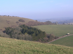
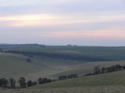
This hill is an old hill fort dating from the 2nd Century BC, and the expansive views showed why ancient peoples would have built a fort there. It was magnificent, and when I stumbled across the trig point beside a topograph (both partially hidden until the last moment by the ramparts of the fort) the Kate Bush song, 'Cloudbusting' came onto my Walkman. The lyrics "On top of the world, looking over the edge" seemed particularly apt, and I felt elated as I walked on across the fort and onto a long stretch of road. Here the bridleway section of the National Trail rejoined, and a good track took me downhill past Whitepool Farm (where there was indeed a pool, although it was not white), and onto a short stretch of road.
This was followed by a climb along a track, and as the skies were slowly starting to darken I realised that I had to push on, and I was glad to know that this was the last climb of the day. As I headed northeastwards uphill a could see a line of shooters ahead of me, their shotguns occasionally going 'pop!' at the sigh of a bird coming out of the nearby trees. I was relieved when I heard a whistle as I approached them, and as they scattered to collect the fallen game I exchanged pleasantries with several of them.
As the gradient slackened onto Henwood Down a junction with Halnaker Lane was met. It had originally been my intention to divert down to the nearby village of East Meon for the night, but as I had managed to get accommodation immediately on the path further on I continued uphill along the lane. At Coombe Cross the track was surfaced with gravel for a short distance, and there were large bollard to prevent four wheel drive vehicles from using the track, but they did not impede me as I headed uphill. The climb was not strenuous and the top of Salt Hill was soon reached, and this was followed a short distance later by Henwood Down and some radio masts. The trig pillar here sits on top of a reservoir and rather than cross the gate I photographed it from the track, and headed off down the track. Soon a large chain-link fence appeared on my left, guarding some obviously disused military buildings. These were the remains of HMS Mercury, a Royal Navy site that closed a few years ago, and shortly after this I reached the Wether Down Hostel, which was right on the track as advertised.
I booked myself in with the nice lady at reception, and collapsed down onto the bed for a quick rest. I found that I was more fatigued from the early start than the long walk, and after getting changed I went to explore the rest of the Hostel. It was converted a couple of years ago from some of HMS Mercury's accommodation, and as much of the energy, water and waster used by the Hostel is recycled, as should be expected as it is part of the adjacent Sustainability Centre. Despite my tiredness I stayed up until about ten, reading and watching a programme about the 1906 San Francisco earthquake, before eventually retiring to bed after a wonderful day's walk.
Directions
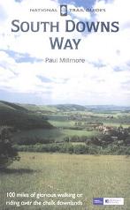
The walk is also covered in detail in the South Downs Way National Trail Guide, by Paul Millmore, ISBN 1 85410 966 9 published by Aurum Press Ltd.
The exception to this is at the beginning of the walk, linking up Winchester station with the start of the National Trail at the City Mill. Leave the station and head straight on downhill for a few yards until a junction is reached. Cross the road and head straight in along the B3330; this curves slightly to the right and then the left; after this second curve turn right down the B3040 Jewry Street. At the bottom of this road turn left along the High Street; continue eastwards along this road and when it ends continue on past a statue of King Arthur and head on to a bridge over the river, with the City Mill immediately to the left.
Distances
| From | To | Distance (m) | Ascent (ft) | Descent (ft) |
|---|---|---|---|---|
| Winchester station | City Mill, Winchester | 1.1 | 23 | 92 |
| City Mill, Winchester | Holden Farm | 6.7 | 761 | 509 |
| Holden | Exton | 5.7 | 466 | 630 |
| Exton | Wether Down | 6.9 | 994 | 522 |
This makes a total distance of 20.4 miles, with 2244 feet of ascent and 1753 feet of descent.
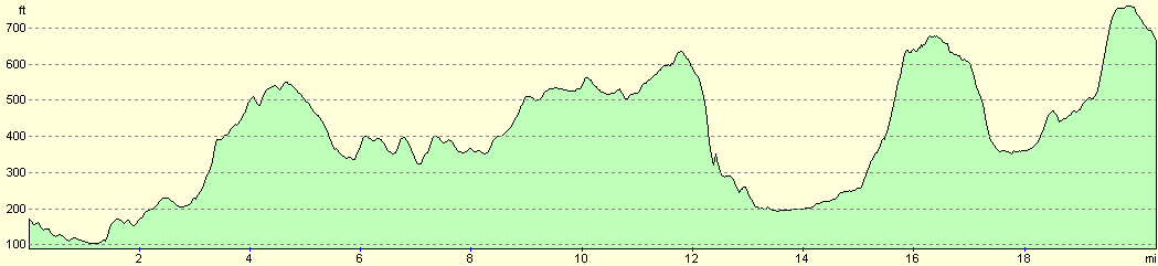
For more information on profiles, ascents and descents, see this page
Accommodation
I spent the night at the Wether Down Hostel, part of the Sustainability centre of the Earthworks Trust. This cost me Ł20.00 for the night (although it is Ł25 in season) for a single room, and the hostel is situated right on the South Downs Way. The woman running the hostel was very nice, and it is situated in pleasant, tree-lined surroundings. There is a small campsite attached to the centre, and it was a most enjoyable place to spend the night.
Disclaimer
Please note that I take no responsibility for anything that may happen when following these directions. If you intend to follow this route, then please use the relevant maps and check the route out before you go out. As always when walking, use common sense and you should be fine.
If you find any information on any of these routes that is inaccurate, or you wish to add anything, then please email me.
All images on this site are © of the author. Any reproduction, retransmissions, or republication of all or part of any document found on this site is expressly prohibited, unless the author has explicitly granted its prior written consent to so reproduce, retransmit, or republish the material. All other rights reserved.
Although this site includes links providing convenient direct access to other Internet sites, I do not endorse, approve, certify or make warranties or representations as to the accuracy of the information on these sites.
And finally, enjoy your walking!
This walk was mentioned in the following routes:
| The South Downs Way |
Nearby walks
| # | Title | Walk length (miles) |
|---|---|---|
| 710 | South Downs Way: Wether Down to Cocking | 18.2 |
| 787 | Romsey to Eastleigh via Winchester | 21.1 |
| 797 | A walk from Wickham to Old Winchester Hill | 23.1 |
|
|

|