Walk #708: Bewdley to Bridgnorth
 |
 |
|
General Data
| Date Walked | 22/01/2006 |
| County | Worcestershire, Shropshire |
| Start Location | Bewdley station |
| End Location | Bridgnorth Station |
| Start time | 08.45 |
| End time | 14.31 |
| Distance | 17.1 miles |
| Description | This was a great walk following the River Severn north from Bewdley to Bridgnorth. |
| Pack | Today I carried my 30-litre Karrimor rucksack filled with my waterproofs, a book and various other odds and ends. |
| Condition | I feel absolutely fine after this walk, and aside from a couple of twinges from my knees I had no problems. |
| Weather | The day started off foggy, and this did not lift until the afternoon, which meant that views were somewhat spoilt throughout the morning. There was no wind and no sign of any wind, and although it was a cold day the lack of any wind meant that I did not get chilled. |
| OS map | Landranger number 138 (Kidderminster & Wyre Forest) |
 |
 |
|
 |
 |
|
Map of the walk
Maps courtesy of Google Maps. Route for indicative purposes only, and may have been plotted after the walk. Please let me have comments on what you think of this new format. For a detailed table of timings for this walk, please see the table file.
 |
Notes
I managed to get a very good night's sleep in the B&B, and when I awoke in the morning I opened the curtains expecting to see the lovely day that had been forecast. Instead I was disappointed to see a grey pall of fog hanging over the garden, and I found myself fervently hoping that it would lift before I set off. I read some more of the book about the War of the roses before breakfast, and after having a filling meal I slowly packed up and got ready to leave the B&B. After saying goodbye to the landlord and landlady, thanking them for an enjoyable stay, I got in my car and started driving through the fog down towards Bewdley. Once there I soon found the Severn Valley Railway station, and parked in a little car park at the bottom of the road from the station.
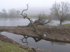
Fog was hanging over the Severn as I approached the river, and where I had got great views over the river yesterday afternoon, there was now next to nothing to be had, the houses on the other side of the river only just being visible through the fog. This was disappointing, and as I started along the Severn Way northwards, passing some boat houses before reaching open countryside, I found myself in slightly low spirits. I found my spirits lifting as I walked, however, as the path was good and the fog did not seem as bad as it could have been. Soon after leaving Bewdley I came across an abutment to the right, and some stone piers in the river. This was the remains of the Dowles bridge, which carried the Tenbury & Bewdley railway over the Severn. When it was intact this bridge consisted of three lattice girder deck spans of 70ft on stone abutments and piers (see a website about the bridge. The first train passed over the Dowles Bridge on the 5th August 1864, shortly after the main Severn Valley Railway line opened.
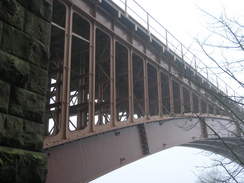
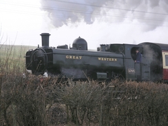
The path joined a road for a while through North Wood, and when this came to an end it climbed up to join the railway line near a little car park. As I passed this point a steam engine came past light engine, and I managed to get a couple of shots of it. To my left was the magnificently impressive Elan Valley Aqueduct , a bridge over the river carrying part of a 73-mile long pipeline from the Elan Valley in Wales to Birmingham. The pipeline opened in 1904, and I was surprised to discover it - it was a civil engineering structure that I knew nothing about.
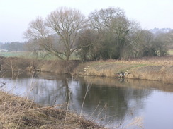
A pleasant stretch of path continued on, skirting around the southern and western edges of the Trimpley Reservoirs before leading me suddenly to Victoria Bridge, a massive 200-fot span arch over the Severn made by the Coalbrookdale Company. It is a famous bridge, and I was annoyed to find that the views of it were spoilt slightly by the fog that hung heavily over the river. A short distance further on the path reached Arley, where the Severn Way crossed the river by what was, in comparison to the magnificent arch bridges I had just passed, a boring girder bridge. The path along the western bank of the river continued in much the same spirit as that on the eastern bank, and I enjoyed the stroll northward. The bridge across Borle Brook turned out to be a little gem, and although dishevelled and in need of paint it was superb little structure.
Shortly after this the path joined a short stretch of road through Highley, and another stretch of path led to a construction site to the north of Highley. Here a pedestrian bridge stretched across the river, and next to it a new concrete bridge was being constructed as part of the National Cycle Network. I enjoyed (in my sad way) looking at the construction methods being used on the new bridge. Apparently the old bridge has got concrete cancer (rotting of the reinforcing bars within the concrete), and will be demolished once the new bridge is opened. The path headed on towards Hampton lade, where I nipped up to look at the station before heading back to the river, where in summer there is a ferry across the river. The ferry was not running on this winter Sunday, and one of the jetties was on dry land being renovated.
A pleasant stretch of path led on toward Lower Forge, and on the way the fog continued to lift, allowing me to get some good shots of a steam engine as it passed. At Lower Forge the river and path headed away from the railway line, making a pleasant loop, although slightly spoilt by the smell from a nearby sewage farm. A cliff rose up to the left on what was a very pleasant stretch of path, the grass underfoot being dry and the views over the river being very nice. I was feeling very good as I strolled along, and I found myself wishing that the rapidly-approaching Bridgnorth was a few miles further away.
As the path approached the bridge carrying the southern relief road for Bridgnorth over the river it narrowed, being squeezed in between a road on the left and the ricer on the right. In a couple of places the path had eroded partially into the river, but despite this it made for a pleasant walk, with trees hiding the road from the path. Just before the bridge the path widened out into a stretch of floodplain, and to my left I could see the ruins of Bridgnorth Castle standing proud over Upper Town. Once the path started squeezing once more between some houses and the river the path became grubbier, and there was lots of litter everywhere, reminding me more of a city centre walk that a mainly rural one.
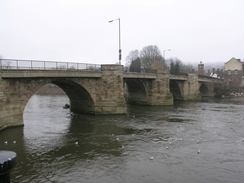
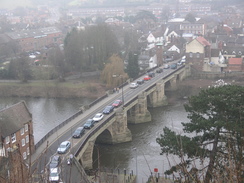
The path erupted out onto the promenade with a surprising suddenness, and as I strolled the short distance to the old bridge the views were much improved. I went to stand on the old bridge and looked downstream, the fog finally having fully lifted and the sun glinting off the water. To my left I saw a hotel that I stayed in for a wedding ten years before, and I walked past this to the entrance to the funicular railway, Britain's only inland cliff railway, and the steepest in the country as well. I did not take the railway and instead went up a wonderful set of steps that led uphill between houses, iron arches overhead keeping the walls apart. It was a great walk, and at the top I joined a footpath that skirted the edge of Upper town, and which gave me some good views over the River Severn below, and this made me doubly glad that the fog had lifted.
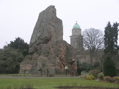
The remains of the 12th Century Bridgnorth Castle are quite amazing - it was blown up in 1647 after being surrendered by Royalist troops the year before during the Civil War. The Keep now leans at fifteen degrees, making it look quite precarious. It has been this way for hundreds of years, but it looks as though it could fall down at any time. After walking around the ruined Keep I headed back to Castle walk, and then headed down some steps that led to the footbridge that leads over to the Severn Valley Railway station at Bridgnorth.
A train was due to leave in about half an hour, so I pottered about in the shop before watching the locomotive run around the train. In the shop I bought a book about Thomas Telford, the great engineer, so once I had used up my remaining photos on engines in the yard I sat back in a carriage, self conscious about my slightly muddy clothes, and started reading. The journey back to Bewdley on the train was highly pleasant; as far as I can recall it is the first time I have had a trip on a steam train at the end of a walk, and it added a slightly magical element to the day's walk. The two walks that I have completed this weekend link up two sets of previous walks, and means that I have got over eleven connected walks on the England-Wales border, a number that I hope to increase in the near future.
Directions
This walk starts off at Bewdley railway station. Leave the station and head down the approach road, which ends at another road by some car parking spaces. Here turn left, and head down another road for a short distance towards a larger road, and the turn right to head northeastwards, approaching the river before reaching the old bridge over the road in Bewdley. Here the route joins the Severn Way, which it will follow all the way to Bridgnorth. Do not cross the bridge, but take a footpath that heads past the site of the old toll booth and head northwards along the eastern bank of the river. About a mile out of Bewdley the path passes the abutments of an old railway bridge, with pillars standing in the river, and further on joins a road for a short distance through North Wood.
When the road ends by the Elan Valley Aqueduct join a path that heads downhill, skirting between the Trimpley Reservoirs and the river before heading north to pass under the magnificent Victoria Bridge. From here it is a short distance to Upper Arley, where a footbridge leads over the river; cross this bridge and once on the other side turn right to start following the western bank of the river northwards. The path is easy to follow as it heads towards and through Highley, north of which is a cycle bridge over the river, and on towards Hampton Loade. The path continued north following the riverside towards Lower Forge, where the path makes a large loop along with the river, before passing under the Bridgnorth Southern Bypass bridge and entering Bridgnorth.
Once the old bridge is reached in the town turn left, and when the road immediately curves to the left head straight on, passing a hotel on the right before reaching the bottom station of the cliff railway. From here a set of steps lead uphill towards the aptly-named High Town. At the top of the steps turn left to join a footpath, Castle Walk, that skirts the edge of High Town, giving some superb views over Low Town and the river. Follow this path as it leads towards the gardens where the ruins of the castle can be found, and when the path curves to the right turn left to go down a flight of steps to join a road. Turn right along this road for a short distance and then turn left, to cross a long footbridge that leads to Bridgnorth railway station, where this walk ends.
Distances
| From | To | Distance (m) | Ascent (ft) | Descent (ft) |
|---|---|---|---|---|
| Bewdley station | Highley | 8.2 | 771 | 741 |
| Highley | Bridgnorth station | 8.9 | 476 | 441 |
This makes a total distance of 17.1 miles, with 1247 feet of ascent and 1182 feet of descent.
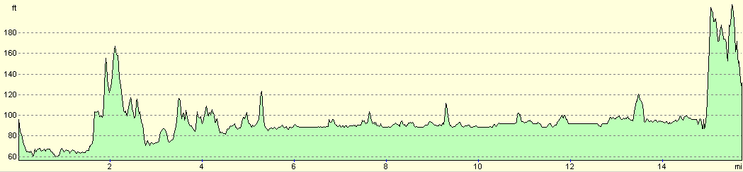
For more information on profiles, ascents and descents, see this page
Transport
The Severn Valley Railway company run regular train services between Bridgnorth and Bewdley; these do not run every day, but you can find times on the Severn Valley Railway website. A single ticket cost me about eight pounds, and although this may be more in the summer season it is well worth it as the steam-hauled journey is a magnificent one.
Disclaimer
Please note that I take no responsibility for anything that may happen when following these directions. If you intend to follow this route, then please use the relevant maps and check the route out before you go out. As always when walking, use common sense and you should be fine.
If you find any information on any of these routes that is inaccurate, or you wish to add anything, then please email me.
All images on this site are © of the author. Any reproduction, retransmissions, or republication of all or part of any document found on this site is expressly prohibited, unless the author has explicitly granted its prior written consent to so reproduce, retransmit, or republish the material. All other rights reserved.
Although this site includes links providing convenient direct access to other Internet sites, I do not endorse, approve, certify or make warranties or representations as to the accuracy of the information on these sites.
And finally, enjoy your walking!
Nearby walks
| # | Title | Walk length (miles) |
|---|---|---|
| 177 | Bridgnorth to Broadstone | 15.5 |
|
|

|