Walk #707: Worcester to Kidderminster via Bewdley
 |
 |
|
General Data
| Date Walked | 21/01/2006 |
| County | Worcestershire |
| Start Location | Worcester Shrub Hill station |
| End Location | Kidderminster station |
| Start time | 09.54 |
| End time | 17.23 |
| Distance | 22.2 miles |
| Description | The majority of this walk was a superb walk following the Severn Way northwards beside the river, the exception being the last few miles along roads to the centre of Kidderminster. |
| Pack | Today I carried my 30-litre Karrimor rucksack filled with my waterproofs, a book and various other odds and ends. |
| Condition | My left knee ached considerably for the first ten miles or so, but this eased up and gave me no further trouble. I had a few twinges from my right knee, but this was sporadic and not troublesome. The worst problem that I had was some bad chaffing on the inside of my thighs, which I will have to treat before tomorrow's walk. |
| Weather | The weather today was quite nice for the time of year; the temperature was above freezing although it was not too mild. There was little breeze and for the majority of the day it was bright and sunny with scattered clouds. |
| OS map | Landranger number 150 (Worcester & The Malverns, Evesham & Tewkesbury) and Landranger number 138 (Kidderminster & Wyre Forest) |
 |
 |
|
 |
 |
|
Map of the walk
Maps courtesy of Google Maps. Route for indicative purposes only, and may have been plotted after the walk. Please let me have comments on what you think of this new format. For a detailed table of timings for this walk, please see the table file.
Notes
Last weekend I had intended to walk between Worcester and Bridgnorth, a two-day weekend walk following the Severn Way. When I got up last Saturday the weather forecast for the west midlands was poor and so I cancelled the walk and did a different one on the Sunday. However the walk was still high on my priority list, and as the forecast was better for this weekend I headed off and started driving west along the A14, M6 and M42. The journey was very good, and I found myself pulling into Kidderminster station a few minutes over two hours after I set off, which had been much faster than I had expected. I paid the car parking ticket of £2.50, threw my gear together and headed to the fairly pedestrian buildings that mark the main line railway station. It turned out that I had forty minutes to wait for the next train, and that once it reached Worcester In would be setting off just before ten. This was a slight blow as this is a late start at this time of year, but I still reckoned that I could reach Bridgnorth before dark.
Whilst I waited for the train I had a look around the area, studying particularly the Severn Valley Railway buildings. The terminus of the SVR is a superb station building, complete with pub, and although the ticket office was open there was no-one about to ask how much a single ticket from Bewdley to Kidderminster would be. It was a pleasant building, and I spent a few minutes studying a poster marking the names of all GWR employees who died during the First World War. After this I walked around the large car park before eventually settling down at the station to wait for my train.
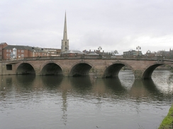
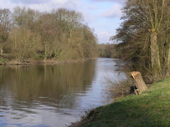
I arrived at Worcester Shrub Hill station at the expected time, and I started walking through the town towards Foregate Street station, where a couple of other walks had started. This side of Worcester was not too pretty, but as I headed from Foregate Street towards the river it improved massively, and there were some good views and architecturally pleasant buildings for me to look at. The bridge over the river was soon crossed, and I then joined the Severn Way footpath that headed north along the western bank of the river. It was a good walk, and to my right In could see the white railings of Worcester Racecourse. The view bought back memories of television pictures from a few years ago when the river totally flooded the racecourse, and as I looked to my left I could see modern houses built slightly raised from the plains. All the older adjacent housing were at a higher level, and this left me wondering if the newer houses were high enough to avoid the worst floods.
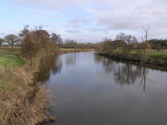
The path beside the river was easy to follow and although there were often trees between myself and the river, I got some fairly good views. There were lots of rowers on the rivers, both singles, doubles and eights, and this gave me more of interest to look at as I strolled along Near Hallow Park there was a large truck blocking the path, and further on there were signs that the trees adjoining the river were being cut down. The sound of a chainsaw soon became audible, and a couple of minutes later I came across a tracked digger and some men, one of whom was high up in a tree with a chainsaw. They were using the digger to prevent cut branches from falling in the river, and as they saw me approach they very nicely let me through with the minimum of fuss and delay.
A little further on the path passed the pretty Bevere Lock, and I started wondering where the path went past the next village, Grimley. On my old OS map the Severn Way is not well marked, and there was no path following the river. Eventually when the path was parallel with Grimley a track was met, and a way marker point up the track. In Grimley itself the way marking was terrible, and after passing the church the path seemed to head slightly north of westwards, as it does on the map. However the path that I was on continued westwards instead of curving to the northwest, and when the path reached a long conveyor belt from the nearby sand pit I realised that I had gone wrong. Instead of backtracking I walked along the track towards the sand pit, which had a fascinating collection of machinery within it as well as large piles of various granularities of sand.
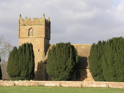
A large path diversion took me around the sand pit, depositing me out on the other side at the bottom of a track that led to Top Barn Farm, which seems to be more of a complex of small businesses that a farm. A good track took me on to Holt, where the pretty church is directly opposite a grand tower on the other side of the road. Another track led on, and then a footpath descended down to reach the Telford-built Holt Fleet Bridge over the Severn. I had to cross this carefully as the road was quite busy and the pavements narrow, but once on the other side I was glad to see that the Severn Way rejoined the river bank, although this time on the eastern side of the river.
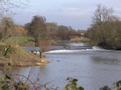
The path headed north, passing Holt Lock before curving to regain a northerly course. The walk was highly enjoyable and very easy, and I started setting myself targets - in the next twenty minutes I would reach this point, in the next thirty that point. This helped me while away the time, and also meant that my pace was also quite rapid. The eastern bank of the river was not very built up, with only the occasional house perched on the riverbank, which slightly surprised me given that the Severn is one of the major rivers of Britain. Eventually an attractive stretch of river led me to the southern outskirts of Stourport-on-Severn, and on over the entrance to a little marina to the river locks at the end of the Staffordshire and Worcestershire Canal. I was interested to find that there were two sets of lock, a narrow and a broad set, with one canal actually climbing over the other one slightly inland, making quite a nice scene.
Stourport-on-Severn itself seemed to be a pleasant place, and I enjoyed my walk along a well laid-out and tidy riverfront through the town. After passing under the bridge carrying the A451 over the river an area of parkland took me north out of the town, and after that I was back on good riverside footpaths. My next target was Bewdley, only three miles away, and although I was starting to feel slightly tired I still tried to keep to a good pace as I walked northwards. Just before reaching the A456 bridge over the river the path went through a narrow rock cutting to avoid an outcrop into the river; this was a pleasant change after all of the riverside walking, and I found myself feeling disappointed that the walk would soon be ending.
Bewdley did not appear until the last minute, the attractive riverside façade of the town being visible across the river only a few minutes before I reached the old bridge over the river. I instantly liked the town, which was very attractive, and once I stood on the middle of the bridge, looking downstream along the river, I started to ponder what to do next. The next train on the Severn Valley Railway to Kidderminster was not for nearly an hour, and as Kidderminster was only four miles away I decided to walk it instead. Sorry to be leaving Bewdley behind me I set off along the B4190 out of the town. Once I got away from the river the town became less attractive, with some fairly pedestrian housing estates on the hillside to the northeast. Once on the A456 I was glad to find a pavement beside the road, and the skies started to darken as I passed the entrance to the West Midlands Safari park.
Night increasingly encroached as the road climbed uphill on the western outskirts of Kidderminster, and I started putting my camera away as there was little that I could photograph in the dusk. Instead of passing right through the centre of the town I decided to follow the ring road around the eastern side of the town, and this increased the distance I walked slightly. There was little of interest to see around me, so I turned the volume of my Walkman up and plodded on, eventually reaching Kidderminster station at the same time a stream of people were leaving the station from the train that I would have caught if I had stopped at Bewdley! Pleased that I had made the same time I walked to my car, took my gear off and started to find details of the B&B that I had booked.
This turned out to be quite near and easy to find, although the off-road parking at the rear of the B&B was slightly confusing in a jolly way. I booked myself in, chatted to the pleasant owners for a while, and then had a shower. On the bookshelf there was an illustrated book about the War of the Roses, and I started to read this, getting increasingly engrossed with the story of the Kings who reigned in that turbulent period of English history. My stomach eventually started rumbling, and so I headed out to the nearby pub that the landlord had recommended. This was a ten minute walk away, and when I got there the place was absolutely heaving. I tried to get a table for some food, but was told that there would be a 45 minute wait. Not wanting to wait that long and not wanting to move I bought a pint and a packet of crisps, and these were followed by a couple more as I sat back reading a novel. It had been a good day's walk, and tomorrow's walk up to Bridgnorth promised to be equally good.
Directions
This walk starts off at Worcester Shrub Hill station. Leave the station and turn left to walk down the sloping approach road that leads to the B4205 Midland Road. Turn right and start following the B4205 northwestwards, passing a grand factory on the right before reaching a junction; here turn left and, shortly after the B4550 is reached, turn right to walk westwards along Lowesmoor. When this meets the A38 turn right and then after a few yards left, to follow the B4205 The Butts westwards; Foregate Street station is fifty yard away to the right at the next junction. If not visiting Foregate Street station, turn left instead and follow Foregate Street southwards. Pass one junction on the heft and then when road curves to the left, turn right down Angel Street. As this ends turn right down a pedestrianised road and then turn right once more to follow a road westwards to the A44 Deansway. Cross this road and head straight on to the river, and cross the bridge carrying the A44 over the river.
Once on the other side of the river turn right, and start following the footpath that runs along the western bank of the river northwards. This route is the Severn Way, which this walk will follow as far as Bewdley. Continue on northwards for a few miles as the path heads out of Worcester, and about a mile after Bevere Lock a track is reached to the east of Grimley. Turn left along this track to leave the river for a few miles, and when the track reaches the end of a road in the village follow the road as it turns sharply to the left towards the church. At the church a footpath leads off to the right, heading westwards before heading in a more northwesterly direction towards a sand pit. A diversion is in place around the sand pit, but this is well waymarked and leads out to head in a more northerly direction along a track towards Top Barn Farm. Just before the farm is reached the track jinks to the right and then immediately to the left, to climb a slight hill to reach the farm buildings.
From Top Barn Farm follow the good track that leads northwards to the village of Holt; pass the church on the left and continue along the track northwestwards for a few hundred yards. When the track curves to the left take a footpath that heads off to the right immediately after the bend; this leads downhill northwestwards with a rough to the right. This heads through a small patch of trees before reaching the river bank of the Severn. At the river turn left, and walk past a pub to reach the A4133 at Holt Bridge. Climb up onto the road and turn right to carefully cross the bridge on the narrow pavement, and then turn left to descend some steps back onto the river bank. Here the Severn Way rejoins the river, although this time it follows the eastern bank of the river.
Continue on northwards along the eastern bank of the river for a few miles, passing through Stourport-on-Severn and eventually, about three miles later, reaching Bewdley. Pass under the A456 bridge to the south of Bewdley and follow the path as it enters the village. Once the old bridge over the river is met in the centre of the town backtrack slightly and join the B4190 road. After a few yards this turns sharply to the left, to head under a railway bridge and head northeastwards out of Bewdley. When the B4190 heads off to the left continue straight on for another couple of hundred yards until a large roundabout with the A456 is reached.
Here join the A456 and follow the road eastwards; there is a pavement for the entire way to Kidderminster. The road passes the entrance to the East Midlands Safari Park, climbs uphill and then starts to descend down into the centre of the town. Cross the junction with the A4535 and head on to join the dual carriageway that runs around the eastern side of the town. Follow this as it descends down towards the River Stour, and then use a pedestrian underpass to swap over to the eastern side of the road. Continue along the dual carriageway as it curves around to the right, taking a more southerly direction, and then when the A448 leads off to the left at a roundabout follow it uphill. Kidderminster railway station, where this walk ends, is a short distance up this hill on the right.
Distances
| From | To | Distance (m) | Ascent (ft) | Descent (ft) |
|---|---|---|---|---|
| Worcester Shrub Hill station | Holt Fleet | 8.5 | 269 | 335 |
| Holt Fleet | Stourport-on-Severn | 5.9 | 243 | 220 |
| Stourport-on-Severn | Bewdley | 3.9 | 125 | 125 |
| Bewdley | kidderminster station | 3.9 | 420 | 289 |
This makes a total distance of 22.2 miles, with 1057 feet of ascent and 969 feet of descent.
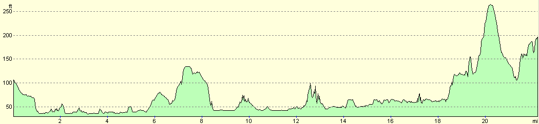
For more information on profiles, ascents and descents, see this page
Accommodation
I stayed at Beulah Villa, which cost me £27.00 for the night for a single room. They can be contacted at Beulah Villa, 187 Chester Rd North, Kidderminster, Worcestershire, DY10 1TN, Tel: 01562 67148. This was a pleasant enough place to spend the night, and the owners proved to be very friendly.
Transport
There are regular train services running from Kidderminster station to Worcester Shrub Hill or Foregate Street stations. When doing this, ensure that you leave from the National Rail station at Kidderminster, and not the grander Severn valley Railway station across the courtyard.
Disclaimer
Please note that I take no responsibility for anything that may happen when following these directions. If you intend to follow this route, then please use the relevant maps and check the route out before you go out. As always when walking, use common sense and you should be fine.
If you find any information on any of these routes that is inaccurate, or you wish to add anything, then please email me.
All images on this site are © of the author. Any reproduction, retransmissions, or republication of all or part of any document found on this site is expressly prohibited, unless the author has explicitly granted its prior written consent to so reproduce, retransmit, or republish the material. All other rights reserved.
Although this site includes links providing convenient direct access to other Internet sites, I do not endorse, approve, certify or make warranties or representations as to the accuracy of the information on these sites.
And finally, enjoy your walking!
Nearby walks
| # | Title | Walk length (miles) |
|---|---|---|
| 697 | Bromsgrove to Worcester | 17.3 |
| 698 | Worcester to Malvern | 11.4 |
| 708 | Bewdley to Bridgnorth | 17.1 |
|
|

|