Walk #706: Brentwood to Liverpool Street
 |
 |
|
General Data
| Date Walked | 15/01/2006 |
| County | Essex, London |
| Start Location | Brentwood station |
| End Location | Liverpool Street station |
| Start time | 08.57 |
| End time | 15.53 |
| Distance | 21.3 miles |
| Description | This was a straightforward walk heading southwestwards from Essex into the centre of London. |
| Pack | Today I carried my 30-litre Karrimor rucksack filled with my waterproofs, a book and various other odds and ends. |
| Condition | I am quite tired after this walk, but aside from that feel fine. My knees ached a bit, but the relatively flat terrain meant that this was not too serious. |
| Weather | The day was generally cloudy, with occasionally sunny periods. It was not too cold a day, but the breeze was quite chilling when I was exposed to it. |
| OS map | Landranger number 177 (East London, Billericay & Gravesend) |
 |
 |
|
 |
Map of the walk
Maps courtesy of Google Maps. Route for indicative purposes only, and may have been plotted after the walk. Please let me have comments on what you think of this new format. For a detailed table of timings for this walk, please see the table file.
Notes
It had been my intention for some time to walk through the centre of Essex from London to Colchester, and towards the end of last year I had started this off by walking the long stretch from Brentwood up towards Hatfield Peveril. This left two sections to be completed, and as I was looking for a walk that would be easy on my knees, I decided that the southern stretch into the centre of London would be the best choice. This involved a long stretch of road walking, and although it would pass through some places that are hardly classic walking territory, it would at least not place too much strain on my body. The good public transport in London also meant that I could cut the walk short if I wanted. |I therefore found myself setting off early in the morning for the drive down from Cambridge, and I managed to make good time as the M11 and M25 were not very busy. I therefore arrived at Brentwood station in good time, and after parking past a long line of taxis I started to put all my kit together ready for the walk.
Because of the nature of the walk I was not expecting it to be a particularly good walk, and whilst scenically it was poor, there was plenty of interest to look at as I walked along. This certainly turned out to be the case as I walked away from the station in Brentwood, climbing uphill along a road that was fairly boring, although the pavement made for a very easy walk. The first item of note was an attractive brick gatehouse at the entrance to a hospital complex, and this made me think about how none of the modern hospitals ever made such outlying buildings so attractive - function and money taking priority over form.
The road continued on to reach Great Warley, which was a pretty little village with a simple cross-shaped war memorial on a triangular village green. The setting is pleasant, and the pub, the Thatchers arms, nestles well in the surroundings. I stopped to take a few photographs of the war memorial and buildings before heading off down a narrow lane, turning off after a while to head down a surfaced lane. This soon became enclosed on either side by trees, stark and bare without the summer foliage, and as I descended the noise of the rapidly-approaching M25 became increasingly audible. The lane ends and a bridleway skirts the top of a cutting on the south side of the M25 where I saw some bushes of Gorse in bloom, and I then reached a bridge over the motorway. I hurried across, and was pleasantly surprised to find a little country park on the other side. Although the buzz of vehicles on the M25 still hung heavily in the air it was a pleasant spot, and I followed a bridleway that initially paralleled the motorway before heading off in a more westerly direction.
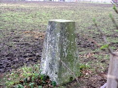
At the edge of the country park the bridleway continued on westwards towards Great Tomkyns; here I had a little problem as there was a junction in the paths, and it was not obvious which one I should take. After a few moments of contemplation I struck off on one path, but after a few yards it was obvious that I had taken the wrong path and so I used a gap in the hedge to get onto the proper path and progressed the short distance to my next target, the Tomkyns trig pillar. This was the main reason why I had planned this rather circuitous route into central London. Unfortunately as I approached I could see that the trig pillar was in an area of pasture right next to the field in which the footpath runs, but as I did not want to trespass into the pasture (which had a couple of horses in it) I just took photographs from the outside.
A short stretch of footpath took me on to a road, and then past a narrow, dark section with hedges looming overhead to another road. A fairly pedestrian footpath led on to a road, and this marked the start of another stretch of country park, and the last significant patch of greenery that I would see all day. The path was well walked and firm underfoot as I headed down towards the Ingrebourne River; however the ambiance was rather spoilt by plastic bags containing 9presumably) dog mess that had been left beside the path. Quite why people bag the poo and then leave them on the ground at seemingly random places I do not know... At the little bridge over the river (which is scarcely a stream at this point) I said hello to a fisherman, and continued on along a boggy patch of ground towards the A127 dual carriageway. The path did not continue under the road and so I climbed up to the road, which was fairly busy and so I had to wait to cross to the central reservation, and then once again to finally reach the southern side of the road. Here I found a farm track, and bade goodbye to scenery as my walk entered the urban areas of Greater London.
The next few miles passed through some wide suburban streets, still sleepy late on this Sunday morning. On one of these roads I came across some flowers next to a tree, a shrine to a teenager who had died I pressed on, and as I approached Romford the streets became less suburban and more urban, until I eventually found myself swept up into the outskirts of Romford. I had no intention of going through the centre of the town, and so I bypassed it to the south using the rig road, where I came across a restaurant stylishly housed in an old building supplies store. This was a pleasant discovery, and a little alter on I found another - a subway under the A118. Usually subways are dank, dreary affairs, but this one was actually quite pleasant - neatly trimmed bushes and brick walls without a covering of graffiti.
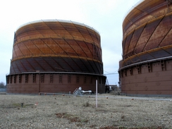
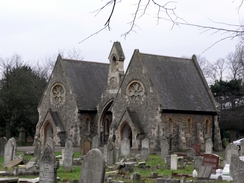
The next road passed some gasholders on the right, part of Romford Gas Works, and Romford Cemetery on the left, which had an attractive little chapel in the middle of it. After these were passed the walk was fairly boring and I put myself on autopilot as I joined the A118 and headed southwestwards through East London. Eventually I reached Ilford, where things started to get more interesting. Firstly there was a massive crane blocking the pedestrianised section of the road; this was probably one of the largest road cranes that can be used in the UK, and I watched it for a while and took photographs of the fascinating machine. I had not been expecting Ilford to be very nice but I was pleasantly surprised - the pedestrianised High road through the centre is neat and tidy, and the shops around it are also quite nice. The jewel in the crown is the Town Hall - a magnificent building that house Redbridge Council. The town was bustling on this Sunday afternoon and it seemed a very friendly place - as I say, it was a very pleasant surprise.
Things changes once more as I crossed the River Rodding and passed under the A406 flyover and a long plod along the A118 through Manor Park and Forest Gate. There was less of interest to see, but navigation was easy and so I once again found myself on autopilot. A strange incident occurred in Forest Gate, where a coloured lady bent over as I crossed a road to pick up her bag, and flashed me her privates in the process; something I could hardly avoid as I walked across the pedestrian crossing towards her. In Stratford I started to get into territory that I know better, and after passing the church and wonderful memorial I walked on down the A11 towards the Bow Flyover.
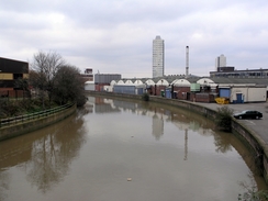
On the way I crossed a couple of the rivers and canals that dominate this part of East London. This added interest to the walk, and after crossing the A12 at Bow Flyover I passed a church that is situated in the middle of the A11 - hardly a salubrious place for an attractive structure. Soon the 'Ferodo' railway bridge came into view and I reached Mile End tube station, which I used to visit daily when I was at University The area is now dominated by the Green Bridge, a large bridge over the Mile End Road that allows the parks to the south and north of the road to be linked, creating the Mile End Park. It has much improved the area, although I was slightly wary when I crossed the bridge and was greeted by comments from a bunch of youths at the top.
Descending from the bridge I crossed the Regents Canal, the start of many walks in the past, and walked past the main campus of Queen Mary College, London University. Memories came flooding back as I walked, and I was slightly annoyed that the campus was locked up on this Sunday afternoon, as I would not have minded having a wander through it. My next target was Stepney Green, and I diverted off the road slightly to have a look at the old Halls of Residence in Stayner's road that I lived in for a year when I could hardly walk. Full of memories I pushed on down the Mile End road towards Whitechapel to find the are both massively changed and the same; a large supermarket had improved the area, and the old cinema, derelict when I used to walk past (a faded poster for 'Scandal' still in a frame) had reopened. The old Almshouses near Whitechapel were just the same, however, and the shops to the southern side of the road looked unchanged.
In Whitechapel I had hoed to nip into the Blind Beggar, a famous pub that I used to frequent, but found that it was shut. This pub is where Ronnie Kray shot George Cornell on March 9, 1966, an event that led to their downfall. The pub had always had oodles of character, and I was interested to see whether a recent renovation had spoiled the atmosphere in any way. Whitechapel has loads of memories for me, and as I walked I found them all coming back to me - regularly visiting a girlfriend in the area, meeting another friend for tea in the hospital cafe, going around the market with Gabrielle. They were all nice memories, and these took me on from Whitechapel towards Aldgate. A large underpass took me through towards St Botolph's Church, which is used as a homeless refuge. The streets took me on as the skies overhead started to darken, and I passed a couple of places where old and new juxtaposed weirdly - an old church overshadowed by a tall office building, an old decorated fire station next to glass-fronted buildings. It was a nice walk, but the length of the day meant that I was relieved when I reached Liverpool Street station, and as I waited for my train back to Brentwood I could look back on what had been a surprisingly nice walk through an area of London people rarely choose to walk through.
Directions
This walk starts off at Brentwood railway station. Initially you need to join the B186 King's Parade that heads above the station; this can be done by either leaving the station and following a road until it ends at the b186, or climbing up the steps within the station and leaving through the station exit, which exits onto the B186. Once on the B186 turn left and start following the road as it heads south, climbing uphill before slowly flattening out. Continue along this road until it reaches a sharp bend in the village of Great Warley; here, pass the village cross and head straight on southwestwards along Warley Road. After a couple of hundred yards a surfaced track, Beredens Lane leads off to the left; follow this as it descends, initially passing woodland, before ending beside the M25. A little path continues to the left, following the M25 southeastwards for a few yards to a footbridge over the motorway.
Cross the bridge and on the other side turn right to enter a little country park and follow a track northwestwards for a hundred yards up a slight rise until a junction of tracks is reached near a bench. Here turn left, and start following another track and bridleway southwestwards until the boundary of the country park is reached. At the end of the park continue straight on along the bridleway; a footpath leads off to the left, but continue on with the hedge on the left. The bridleway passes a small patch of woodland on the right before passing Howards's Farm and ending at Tomkyns Lane. Turn right along this lane for a few yards and then turn left to join a footpath; initially this squeezes westwards between two hedges before opening out and ending at another road. Turn left down this road to heads southwards for a few yards, and at a car park turn right and start heading downhill along a surfaced track, and when this curves to the right head straight on along a footpath that leads to a bridge over the Ingrebourne River.
On the other side of the bridge the footpath continues on southwestwards for a short distance before reaching the A127 dual carriageway. Very carefully cross the road, and on the other side head straight on southwards along a private track. This soon curves to the right and becomes Hubbards Close, and when this ends at Hubbards Chase turn left and follow this road as it curves to the right and heads westwards to end at Wingleyte Lane. Turn left along this lane and then immediately take Sylvan Avenue that leads off to the right; this road heads in a rough westerly direction for about a kilometre, becoming Woodlands Avenue half way along before ending at a crossroads with Ardleigh Green Road. Turn left along this road to heads southwards for a hundred yards, before turning right up Slewins Lane, which passes immediately to the south of Haynes Park. Before the road ends at a roundabout turn left along Cavenham Gardens; this road heads westwards for a short distance before ending at Brentwood Road.
Turn left and follow Brentwood Road as it heads southwestwards, slowly curving to a more westerly direction and crossing a railway line on a bridge and curving to take once more a southwesterly course. The road ends at a T-junction with South Street in Romford; turn right along this road for a few yards until it ends at Oldchurch road (the Romford ring road). Turn to the left and follow this road westwards for a hundred yards until a large roundabout is reached; here use the underpass under the roundabout to cross he busy road, and then start heading westwards along Oldchurch Road. Immediately to the north is Oldchurch hospital, and after this the road passes some large gasholders to the right and Romford Cemetery to the left. The road becomes Crow Lane before ending at the A1112 Whalebone Lane. Here turn right and immediately cross the railway line on a bridge as it heads northwards and ends at a crossroads with the A118 road.
Turn left and start following the A118 as it heads slightly south of westwards through East London. At Seven Kings railway station the road jinks to the left past the entrance to the station and then continues with the railway line to the right, heading on for another mile before reaching the eastern end of Ilford. here the road jinks to the left, but continue straight on along a pedestrianised stretch of road that passes under a flyover along High Road. Pass through the centre of Ilford along High Road, passing the Town Hall on the left and when the road ends continue straight on along Ilford Hill towards the Rodding River and then the flyover under the A406. Pass under the flyiover and then continue on along the A118 Romford Road for a couple of miles before it ends at a junction with Broadway in Stratford.
At the junction turn let and start following Broadway southwestwards, with a large church in an island on the right. This road is the A11, and follow it southwestwards for about a mile as it passes over a couple of rivers and reaches the Bow Flyover (the junction with the A12). Do not take the flyover but take the lower road that ends at a roundabout; carefully cross the slip roads and continue on along the A11. It soon passes a church in a little island in the road and heads on, passing Bow Road and Mile end stations. Continue on along the A11, passing Queen Mary's College on the right and head on passing Stepney Green tube station before eventually reaching Whitechapel.
From Whitechapel continue on along the A11 towards Aldgate. The junctions become increasingly more complex as the road heads towards the centre of the City, but when the junction with Middlesex Street is reached turn right and then left to follow St Botolph Street southwestwards for a couple of hundred yards. This entire complex of junctions is fed by a series of pedestrian underpasses, and this can be used instead of crossing the busy roads. When St Botolph Road ends turn right up to head northwestwards up Houndsditch, and when this ends at a T-junction turn right up Bishopsgate for a few yards; Liverpool Street station is on the left along this road.
Distances
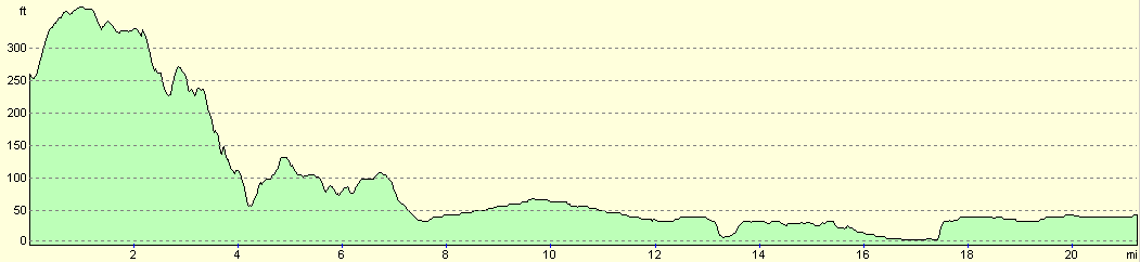
| From | To | Distance (m) | Ascent (ft) | Descent (ft) |
|---|---|---|---|---|
| Brentwood station | Romford | 7.6 | 394 | 620 |
| Romford | Stratford | 8.7 | 95 | 118 |
| Stratford | Liverpool Street station | 5.0 | 56 | 23 |
This makes a total distance of 21.3 miles, with 545 feet of ascent and 761 feet of descent.
For more information on profiles, ascents and descents, see this page
Transport
There are regular train services running from London Liverpool Street station to Brentwood; these are regular eve on a Sunday. A single ticket for the journey cost me £5.70.
Disclaimer
Please note that I take no responsibility for anything that may happen when following these directions. If you intend to follow this route, then please use the relevant maps and check the route out before you go out. As always when walking, use common sense and you should be fine.
If you find any information on any of these routes that is inaccurate, or you wish to add anything, then please email me.
All images on this site are © of the author. Any reproduction, retransmissions, or republication of all or part of any document found on this site is expressly prohibited, unless the author has explicitly granted its prior written consent to so reproduce, retransmit, or republish the material. All other rights reserved.
Although this site includes links providing convenient direct access to other Internet sites, I do not endorse, approve, certify or make warranties or representations as to the accuracy of the information on these sites.
And finally, enjoy your walking!
Nearby walks
| # | Title | Walk length (miles) |
|---|---|---|
| 50 | Paddington to Mile End | 8.3 |
| 51 | Mile End to Enfield Lock | 12.7 |
| 65 | Alperton to Paddington | 6.4 |
|
|

|