Walk #698: Worcester to Malvern
 |
 |
|
General Data
| Date Walked | 20/11/2005 |
| County | Worcestershire |
| Start Location | Worcester Foregate Street station |
| End Location | Great Malvern station |
| Start time | 09.30 |
| End time | 13.40 |
| Distance | 11.4 miles |
| Description | This was a short stroll on a cold Sunday, linking up Worcester with a previous walk that started in Malvern. |
| Pack | Today I carried my 30-litre daysack, filled with my waterproofs, a water bottle and my normal electrical odds and ends. |
| Condition | Today I had a bit of pain from the toes on my left foot, which had been rubbing against the inside of the boot and were very sore by the end of the walk. Aside from this I had no problems, even from my knees, which was a relief. |
| Weather | Although the forecast was again for sun, I did not see much of this until later on in the day due to the all-pervasive fog that was the main feature of today's weather. It was a very cold day, and the fog was freezing before about midday. There was no wind to help blow the fog away. |
| OS map | Landranger number 150 (Worcester & The Malverns, Evesham & Tewkesbury) |
 |
 |
|
 |
Map of the walk
Maps courtesy of Google Maps. Route for indicative purposes only, and may have been plotted after the walk. Please let me have comments on what you think of this new format. For a detailed table of timings for this walk, please see the table file.
Notes
I awoke quite early this morning, a fact that was nothing to do with the comfortable room, but more to do with a nightmare that had visited me during the night. I was therefore slightly unsettled in the morning, and I whiled away the time before breakfast at 08.30 by typing up yesterday's notes and watching some television. Breakfast was punctual and filling, and after saying goodbye to Michael and the landlord and landlady, I headed off to scrape the ice off the windscreen, an effect of the heavy overnight frost. It took a few minutes to do this and get the car in a driveable condition, and I then drove off to find somewhere to park the car. I wanted to start the walk from Worcester Foregate Street station, and about a hundred yards away from the B&B I found a nice parking spot opposite a swimming pool. Although there were restricted parking on Mondays to Saturdays, there were no restrictions on Sundays, and so I parked up and headed off to the station.
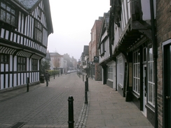
Although I had seen a little bit of Worcester when I walked to the tourist information office last night, I was not prepared for what greeted me this morning. I decided to take a slightly indirect route through the town, heading along pedestrianised streets that I thought would take me through the best areas. This turned out to be a good decision, and allowed me to pass some lovely half-timbered buildings, including one where King Charles II is reputed to have hidden after the Battle of Worcester on September 3rd 1651. It was a very enjoyable walk on a bitterly cold morning, and before long I found myself at Worcester Cathedral.
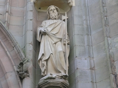
On recent walks I have seen some fairly unimpressive cathedrals - Brentford comes to mind - but Worcester turned out to be classic. As I arrived the bells were marking 45 minutes past, and I started to take some photographs as the bells rung out across the city. I was particularly taken by the doorway, which had some superb statues arrayed around it, and although I could not get a very good photograph of the tower due to the fog, it appeared to be a very pleasant structure as well. The first cathedral on the site was founded in 983AD by Bishop Oswald as part of a Benedictine monastery, and it was rebuilt from 1084 after being partially destroyed in 1041. The restoration was complete by 1218, and although it started to decline after the dissolution of the monasteries, it was extensively rebuilt from 1854. This explains the statues; these are not original, but Victorian additions, and although some may say that this spoils the building, in my eyes they add to the glory.
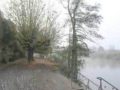
A path took me through some gardens past the end of the choir, and from here I got a superb - albeit foggy - view of the end of the building. Some steps took me down to a riverside path beside the Severn, and I started to walk south along this. I soon reached the locks that marked the end of the Worcester and Birmingham canal, and although the canal towpath was closed for repairs to the locks the riverside path was open, and I walked on towards the riverside locks at Diglis. These were a large affair and were manned, and although I had hoped that I may be able to cross the river at the locks, it was obvious that it was not possible. The walk on southwards would have been quite enjoyable in sunny weather, but the fog made the entire day grey, and at times it was hard to see the other river bank clearly. After a little diversion inland to get around a stream the path entered a caravan park, and I began to hear the noise of traffic before, eventually, the A4440 Carrington Bridge over the river came into view through the fog. This bridge carries the Southern Link Road over the Severn, and according to Basil Drinkwater at the viewpoint to the south of the bridge is totally overgrown and unusable, despite having been provided at great cost by the council.
The bridge soars high above the river and I was concerned if I would be able to get up to the road to cross the bridge; it is the last river crossing before Upton upon Severn, a long way to the south. I used a path that led up from the caravan park reception to a pub beside the A38(T), and here I was relieved to discover that I could access the bridge from the adjacent roundabout. There were pavements on either side of the road, and as I crossed I was annoyed to find that the views over the river were radically foreshortened due to the fog. On the other side of the bridge a track led me down to the riverside path on the western bank of the river, and I started walking south along it. The sound of guns were coming across the river, and as I headed further south these got louder, so much so that a couple of the shots made me jump. I was therefore relieved when the path headed away from the river and passed the farm at Beauchamp Court, where there were a series of poles in the ground with wires hanging from them - for growing hops, perhaps?
I followed the main road south through Callow End, and off to my right I could see a very large building through the fog - the Benedictine Stanbrook Abbey, completed in 1871 and designed by Pugin. The fog meant that it was not worth getting closer for some photographs, so I headed off down the road, nipping into a shop to buy some chocolate on the way. I munched on this as I walked along the road, and although there was a pavement I was glad when a track led away off to the right, leading up to a trig pillar on Old Hills. According to the Trigpointing UK website the views from here are very good, but in the fog I could see virtually nothing, which was a great shame. I did not dawdle at the top but followed a horse and rider down off the hill along an obvious path. This was a mistake, as I soon realised that I had headed southwestwards and not westwards, and so I head to head back across fields to regain the path.
Once I had regained the path the going was easy as it headed westwards, and eventually I reached a track near the farm at Woodsfield. The track led me on, and another path dropped me off at a road at Newland. A short distance down this road I passed the dominant church of the Beauchamp Community, a building that, as far as I could see through the fog, was magnificent. I have not been able to find out much information about this community, and I would like to be able to see the buildings in better weather. There followed a mile-long walk along the A449 down into Malvern Link, and I reached the station about five minutes before the next train was due. I was tempted to catch this, particularly as one of my toes was hurting, but a I had done less than ten miles I resolved to walk on. As I headed up the road, which slowly climbed as it entered Malvern, the fog began to lift.
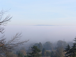
This led to a marvelous sight; as I rose above the fog, I started to see the top of the layer of fog over the rooftops. In the distance Breedon Hill poked over the top of the fog layer, making it look like a dark cloud. This tempted me to climb up North Hill to take some better photographs, but I was keen to finish and get back home, and so I walked on through Malvern, contenting myself with occasional photos over the fog layer. Great Malvern itself is a lovely town; although I had never walked through it before, I had stayed in the town on a previous walk and had enjoyed the place. This had not changed, and as I walked I studied the architecture. In the centre there is an interesting statue of Sir Edward Elgar, who was born nearby, and I photographed this before heading off down the road towards the station. On the way I chatted to a gentleman who had been attending a Labour party conference in the town, and it was nice to be able to chat to someone. Great Malvern station itself was quite interesting (it has a trolley weighbridge on the platform, and lovely flower motifs on the columns supporting the platform canopies). Although today was a short walk it had been an enjoyable one, and it was with satisfaction that I walked around, waiting for the train.
Directions
This walk starts off at the Worcester Foregate Street station; leave the station and turn left to start walking south down Foregate Street. Cross over a junction and take the next road to the left, which heads eastwards to end at New Street. Turn right and head down this through the historic centre of the city until the A44 dual carriageway is reached, and then cross the road to reach the Cathedral. Pass the entrance to the Cathedral and hen head on through some gardens, to descend down to the path on the eastern bank of the River Severn.
Turn left and start walking south along the riverside path. This soon reaches a lock at the junction between the River Severn and the Worcester and Birmingham canal, and heads on down to Diglis lock on the Severn. Continue on for over a mile; the path heads away from the river for a short period to diver around a stream, before returning to the river bank and heading on down into a caravan park. When the reception for the caravan park is reached turn left and pass the reception hut, before climbing up a steep path that rises to pass beside a pub before reaching the A38.
At the A38 turn right for a few yards until a roundabout with the A4440 is reached, and then turn right to heads west across a bridge over the Severn. Immediately on the other side turn right to take a track down onto the valley floor, and then pass over a stile and turn right to head south under the bridge. The path starts to angle towards the river bank, and follows the river southwards for about a kilometre. The path crosses a stream and then turns to the right, to head west until a flood bank is reached, and then to the left to head in a more southwesterly course. The path heads to the north of Beauchamp Court before ending at a road; turn right and follow this road as it heads westwards to reach the B4424 road in Pole Elm.
Turn right and follow the B4424 road as it heads through Callow End. A little over a kilometre later the road turns sharply to the right and then the left; at the later bend continue straight on along a track westwards that climbs uphill to a trig pillar at the top of Old Hills. A path heads off slightly to the north of west, descending downhill where it joins a bridleway that continues westwards until it reaches a track immediately to the north of Woodsfield. Turn left along this track for a few yards and then right, to join another footpath that angles southwestwards to the north of the farm before soon ending at a track.
Turn right along this track and follow it as it heads westwards for about half a mile; when the track ends at a road continue straight on along a footpath that heads westwards for a little under a kilometre until it ends at a road. Turn right and follow the road as it curves around to the left; ignore a road that leads off to the right and continue on along this road until it reaches the A449 road in Newland, right by the magnificent buildings of the Beauchamp Community. Turn left and follow the A449 as it heads southwestwards through Malvern Link, passing the station until it reaches the B4503 road, where it curves sharply to the left to head south towards Great Malvern.
When the B4211 Church Street is reached on the right (beside a statue of Sir Edward Elgar) turn right and start following it downhill. It passes the tourist information office, and when Avenue Road heads off to the right turn right and start following it downhill. After a few hundred yards turn right down a road that is signposted for the station. Great Malvern railway station is a short distance down this road, and is where this walk ends.
Distances
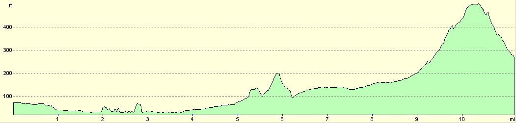
| From | To | Distance (m) | Ascent (ft) | Descent (ft) |
|---|---|---|---|---|
| Worcester Foregate Street | A4440 bridge | 3.0 | 138 | 164 |
| A4440 bridge | Malvern Link station | 6.3 | 381 | 207 |
| Malvern Link station | Great Malvern station | 2.1 | 331 | 285 |
This makes a total distance of 11.4 miles, with 850 feet of ascent and 656 feet of descent.
For more information on profiles, ascents and descents, see this page
Transport
There are regular train services running between Worcester and Malvern, calling at Malvern Link station on the way. A single ticket cost me Ł2.90 for the journey. See the National Rail Enquiries website for more details.
Disclaimer
Please note that I take no responsibility for anything that may happen when following these directions. If you intend to follow this route, then please use the relevant maps and check the route out before you go out. As always when walking, use common sense and you should be fine.
If you find any information on any of these routes that is inaccurate, or you wish to add anything, then please email me.
All images on this site are © of the author. Any reproduction, retransmissions, or republication of all or part of any document found on this site is expressly prohibited, unless the author has explicitly granted its prior written consent to so reproduce, retransmit, or republish the material. All other rights reserved.
Although this site includes links providing convenient direct access to other Internet sites, I do not endorse, approve, certify or make warranties or representations as to the accuracy of the information on these sites.
And finally, enjoy your walking!
Nearby walks
| # | Title | Walk length (miles) |
|---|---|---|
| 651 | Malvern to Ledbury | 16.4 |
| 697 | Bromsgrove to Worcester | 17.3 |
| 707 | Worcester to Kidderminster via Bewdley | 22.2 |
|
|

|