Walk #699: Sudbury to Marks Tey
 |
 |
|
General Data
| Date Walked | 27/11/2005 |
| County | Suffolk, Essex |
| Start Location | Sudbury station |
| End Location | Marks Tey |
| Start time | 08.58 |
| End time | 15.00 |
| Distance | 17.1 miles |
| Description | This walk headed south from Sudbury, following the Stour valley path for about half of the walk. |
| Pack | Today I carried my 30-litre Karrimor rucksack filled with my waterproofs, a book and various other odds and ends. |
| Condition | Aside from some aching in my right knee I feel fine after this walk, and could easily have walked further if I had needed to. |
| Weather | Today was a grey day, and early on there were a few short-lived drizzle showers. The sun started coming out towards the end of the walk, but even then cloud predominated, on what was quite a cold day. |
| OS map | Landranger number 155 (Bury St Edmunds, Sudbury & Stowmarket) and Landranger number 168 (Colchester, Halstead & Maldon) |
 |
 |
|
 |
 |
|
Map of the walk
Maps courtesy of Google Maps. Route for indicative purposes only, and may have been plotted after the walk. Please let me have comments on what you think of this new format. For a detailed table of timings for this walk, please see the table file.
 |
 |
|
Notes
Originally it had been my intention to head back to Worcestershire this weekend, to walk from Worcester along the Severn to Bridgnorth, connecting two separated walks that I have done previously. Unfortunately the weather forecast for this weekend was not too good, and so instead of going away I went shopping in Cambridge. The forecast for Sunday was better, however, and so I looked at doing a local walk. for most of the year I had been considering following the Sudbury branch line from Sudbury to Marks Tey, and today looked like a good opportunity to do this walk.
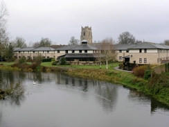
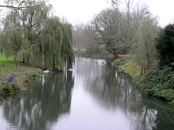
Getting to Sudbury from Cambridge took me longer than I expected, and once I got to the town I lost my bearings and could not find the station. However I knew that I was roughly in the right area, and so I parked up in a leisure centre car park, got my kit ready and asked directions to the station, which turned out to be on the other side of the leisure centre! Once at the station I was tempted to wait for the next train and catch it down to Marks Tey to allow me to do this walk in reverse, but I soon decided against this, and instead headed back round the leisure centre and past my cat to join the old Sudbury to Haverhill railway line, this portion of which is now a footpath, took me along an embankment to the south of the town, skirting the River Stour below to my left.
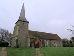
After crossing the entrance to a quay, which gave me some nice views over the town, the path crossed the Stour itself, and shortly afterwards a path led off to the left. It had been my intention to continue walking to a bridge over the road and to follow that, but as the path appeared to be going in the right direction and was well walked, I followed it instead. The ground underfoot was muddy and as I walked I listened to a bunch of commentators on Radio 5 go totally overboard about the death of George Best. In Ballingdon I joined the Stour Valley Path, which I would ed up following for half of the day. Initially this took me uphill, and despite the grey skies it was a pleasant walk to the church at Great Henny, which was a nice little church. Some road walking was followed by a track and finally a path, leading to The Valley Farm and, shortly afterwards a road.
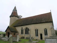
The next objective was Lamarsh Church, and as soon as I saw it from the hillside above I fell in love; it is a Suffolk round-tower church, and it looked absolutely superb as I approached it down the hill. I could not help but take some photos of it, and I was disappointed when I tried the door to find it locked, as I had been hoping to have a good look around inside. A little road walking led me on to a path over the railway line, and this path then followed the River Stour southwards to the village of Bures. Here I took some photographs of the church and resisted the lure of nipping into a pub for a quick pint, before heading on out of the village.
I had wanted to find the path that led down to a bridge over the Stour by a mil, but instead I got side-tracked past some playing fields, replete with Sunday football teams, to a new Millennium Bridge over the river. Once across this I had to get back on course towards the mill, so I followed the western bank of the river southeastwards; a small stream blocked the way, but a brick in the middle of it helped me cross it, and a short distance further on I found the mill, a tall building covered prettily in white clapperboards.
The Stour Valley Path took me on southeastwards, initially crossing fields before climbing up a hill, from where I got some good views back towards Bures, and I soon found myself at Wormingford Church, which was another good example of church architecture. Here I left the Stour Valley Path with regret, as it had been a good path so far. A little road walking led me on to a trig pillar, and then on to the old Wormingfield airfield. The old taxi roads around the outside of this airfield are shaped like a diamond and there are footpaths around all of them, but the two runways themselves are still used by a glider club. The old tarmac on the taxiways was breaking up, but it still made for a good walk as I passes some wooden huts housing the glider club, and shortly afterwards I passes some stored gliders and some other huts housing some Turkeys, all making noise as if knowing what was going to happen to them in a few weeks time ready for Christmas.
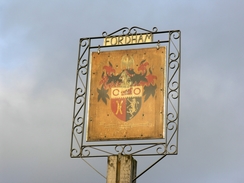
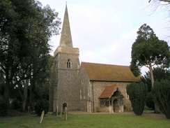
I left the airfield via a track that is not a public right of way, that led southwards to a road. This took me on towards Fordham, and after inspecting the church I headed on along roads to the A1124 at Fordtsreet. This village was quite pretty, but I could not stop for too long as I wanted to catch a certain train, and I did not have much time to spare. Some more road walking took me into Aldham, where there was another pretty church, and I met two girls who asked me why I was taking photographs. I explained that I took many photographs whilst I walked, but they seemed puzzled and just walked away. Some more road walking took me south, crossing the Roman River (anything to do with the Romans, I found myself wondering), before reaching Marks Tey. The time pressure had reduced due to m fast pace, and I bought a ticket and sat down on the single coach train, waiting for it to set off on the journey back to Sudbury.
Directions
This walk starts off at Sudbury railway station. Leave the station and head down the road with a large building - a leisure centre - to the left. Turn left and skirt past the building to reach the entrance to the centre, and then head on through a car park to reach the course of the old railway line. Follow this as it heads westwards skirting to the south of the town; it crosses a bridge over the entrance to a quay, and then the River Stour itself. Once across the bridge turn left along a footpath that crosses some boggy ground southwestwards, before ending at a road in Ballingdon. Turn left to follow this road eastwards for a few yards, and the turn right up a small residential road, Ignore the first road off to the right but take the second, and immediately turn left to join a footpath, part of the Stour Valley Way.
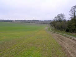
Follow the path as it climbs uphill, initially heading southeastwards before settling on a more southerly course for a couple of kilometres until it reaches the church at Great Henny. Walk past the church and follow the access lane that heads south for about a hundred yards before ending at a road. Turn left and follow this road as it heads eastwards; when it turns sharply to the left continue straight on along a track that passes a farm to the right before curving around to head southeastwards. When this track ends at a house a footpath leads on, initially with a hedge to the right, eastwards for a few hundred yards until a path junction is reached; here turn right to start following a path southwards. It crosses a little stream before climbing up to pass a farm and join a track, which itself heads uphill southwards before ending at a road.
At the road turn left and follow it northeastwards for a short distance until some power lines appear overhead, and then turn right to join a footpath that heads south, before slowly curving to head in a more easterly direction, heading downhill to end at a road near the church in Lamarsh. Turn right and head south along this road; when a junction is reached in the village follow the road as it curves to the left and heads past the village pub. Immediately beyond this, when the road curves to the right, turn left to join a track that heads southeastwards, heading down to the railway line. Carefully cross the railway line on the pedestrian crossing, and once on the other side follow a footpath that skirts the western bank of the River Stour as it flows southwards. This footpath soon joins a track, before ending at a road in Bures.
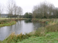
In Bures turn left and follow the B1508 as it crosses the river and, once past the church, turn right down a road. This road passes the end of the church before curving to the left and right, to head southeastwards out of the village. Pass some playing fields on the right, and then take a footpath that leads off to the left, which leads to the mill and a bridge over the River Stour. Cross this bridge, and once on the other side follow the Stour Valley Path as it heads southeastwards along the floodplain of the river. When a track is reached near Staunch Farm turn right along the track for a few yards and then left, to follow a hedge on the left as the path continues southeastwards. The path becomes clearer once the hedge ends and it enters open fields, and it starts to climb uphill. A small valley has to be negotiated, before the path goes through the churchyard of Wormingford Chuch and ends at a road beside the church.
Here this walk leaves the Stour Valley Path, and takes to roads and tracks for the rest of the day. Turn right and follow this road as it heads southwards, entering the village of Wormingford itself before ending at a T-junction with the B1508 road. Turn right along this road and follow it as it heads westwards, passing a pub on the right before a road junction is reached. Here ignore both roads and head straight on westwards along a track; this track passes a trig pillar and when it ends at a T-junction turn left to follow another track southwards. When this track shortly ends at another T-junction turn right to head along a track westwards, immediately passing some farm sheds. Once past these sheds turn left and walk south along a footpath across a field until another track is reached.
This track is actually one of the taxiways of the old Wormingford airfield; turn left and follow it towards the wooden gliding clubhouse, and then on as it curves around to the right to take a more southwesterly course. The track (which is not a public right of way) passes Fairfield Farm as it heads towards the southern tip of the airfield, and just before it curves to the right take a track that leads off to the left, heading south before ending at a road. Turn left and follow this road as it heads slightly south of east, before reaching a crossroads near Moat Hall, and then turn right to follow the road south into Fordham.
Continue along the road as it heads southwards, ignoring a road that heads off to the right near the village sign. Once Fordham Church is reached turn right along a footpath that passes the church before joining a track ; follow this track as it skirts the edge of a filed, turns sharply to the right and ends at a road. Turn left and follow this road for a little under a kilometre until it ends at the A1124; continue straight on along the A1124 southwards as it enters Fordstreet and crosses the River Colne. On the southern side of the bridge take the first road to the right, which initially heads westwards past a garden centre before curving to head southwards for another kilometre into Aldham. Follow the road as it heads south past Aldham Church and onwards; it passes Aldham Hall before crossing the Roman River. The road twists and turns before crossing the railway line on a bridge; the road turns to the right to skirt the railway line to Marks Tey station, which is a few yards away down an access road to the right.
Distances
| From | To | Distance (m) | Ascent (ft) | Descent (ft) |
|---|---|---|---|---|
| Sudbury station | Great Henny church | 2.8 | 312 | 174 |
| Great Henny church | Bures | 4.3 | 240 | 400 |
| Bures | Wormingford | 3.1 | 272 | 118 |
| Wormingford | Fordham | 3.5 | 59 | 115 |
| Fordham | Marks Tey station | 3.4 | 148 | 184 |
This makes a total distance of 17.1 miles, with 1031 feet of ascent and 991 feet of descent.
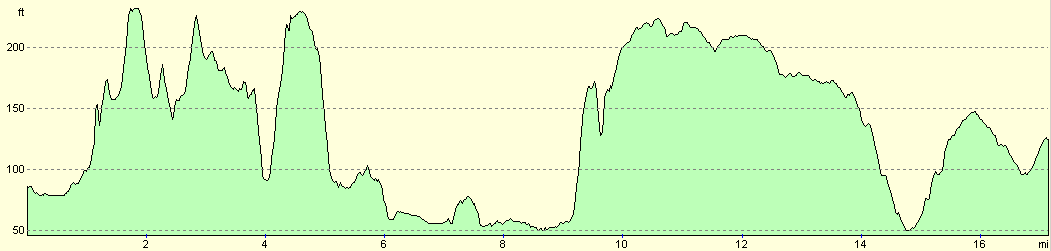
For more information on profiles, ascents and descents, see this page
Transport
There are regular trains services running along the branch line between Marks Tey and Sudbury; these run hourly even on a Sunday. A single ticket for the journey cost me £3.10.
Disclaimer
Please note that I take no responsibility for anything that may happen when following these directions. If you intend to follow this route, then please use the relevant maps and check the route out before you go out. As always when walking, use common sense and you should be fine.
If you find any information on any of these routes that is inaccurate, or you wish to add anything, then please email me.
All images on this site are © of the author. Any reproduction, retransmissions, or republication of all or part of any document found on this site is expressly prohibited, unless the author has explicitly granted its prior written consent to so reproduce, retransmit, or republish the material. All other rights reserved.
Although this site includes links providing convenient direct access to other Internet sites, I do not endorse, approve, certify or make warranties or representations as to the accuracy of the information on these sites.
And finally, enjoy your walking!
Nearby walks
| # | Title | Walk length (miles) |
|---|---|---|
| 270 | Brightlingsea to Fingringhoe | 15.2 |
| 271 | Fingringhoe to Tollesbury | 16.7 |
| 630 | Braintree to Marks Tey | 14.4 |
|
|

|