Walk #700: A circular walk from Haverhill to Clare
 |
 |
|
General Data
| Date Walked | 17/12/2005 |
| County | Suffolk, Essex |
| Start Location | Haverhill library car park |
| End Location | Haverhill library car park |
| Start time | 08.38 |
| End time | 15.10 |
| Distance | 18.4 miles |
| Description | This was an enjoyable circular walk, based on the Stour Valley Path. |
| Pack | Today I carried my 30-litre Karrimor rucksack filled with my waterproofs, a book and various other odds and ends. |
| Condition | I had a bit of trouble with my left knee during this walk, and my left ankle gave me a little gip when heading north from Leys Farm. Otherwise I feel okay, and the walk could have been much worse. |
| Weather | The day was quite fine and sunny, but unfortunately it was quite cold, with a biting northerly wind that was exceedingly cold. |
| OS map | Landranger number 154 (Cambridge & Newmarket, Saffron Walden) and Landranger number 155 (Bury St Edmunds, Sudbury & Stowmarket) |
 |
 |
|
 |
 |
|
Map of the walk
Maps courtesy of Google Maps. Route for indicative purposes only, and may have been plotted after the walk. Please let me have comments on what you think of this new format. For a detailed table of timings for this walk, please see the table file.
 |
 |
|
 |
Notes
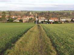
At the beginning of this year I did a circular walk from the village of Clare in Suffolk, and since then it had been my intention to connect this up with previous walks at Haverhill. Events had precluded this, however, and it was only today that I finally got around to doing one. The route planned itself; follow the Stour Valley way from Haverhill to Clare, and then take footpaths and roads west north of the river back to Haverhill. With this in mind I set off, and despite being temporarily delayed by parking in the wrong place (I parked at the library, a short walk away from the bus station and the start of the walk, when there is a perfectly good car park adjacent to the station). It cost me one pound to park for the day, and I soon found myself walking through Haverhill, looking for the bus station. The town was in full Christmas spirit, and as I passed stall holders setting up stalls for a market I get a real blast of seasonal spirit.
Before I reached the station I nipped into a shop to buy some chocolate, and then headed up to the bus station. I visited the stall where I had ended my previous walk from Great Shelford to Haverhill, and then set off on the walk proper. I crossed a small stream and then headed past an ugly leisure centre, to reach the old Cambridge to Sudbury railway line. This line opened in 1865 and closed in 1967, leaving a large gap in the railway network in the area. There are plans by the Cambridge to Colchester Railway Development Company to reopen it, but I am unsure exactly how feasible this will prove to be.
As soon as I joined the path that runs along the old railway trackbed I was greeted with a seat made out of an old set of wagon wheels - a great idea that is totally in fitting with the path. The walk along the path as it headed southeastwards was fairly pedestrian, the only items of any note being a scowling youth who passed me and the sewage works beside the path, whose smell followed me for a few hundred yards. Eventually the path ended at a road in Sturmer, and after looking at the old station house (now extended radically from its original appearance) I walked along the road to join a bridleway.
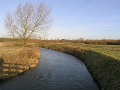
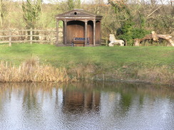
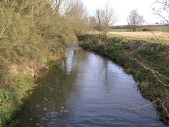
There then followed a nice walk to a bridge over the Rover Stour, and on past Water Hall Farm to a road at Boyton end. This made for a n easy walk south, the only thing of note being the bridge over the River Stour, which carries the A1092 road to Clare over it. This was under repair, and an adjacent temporary scaffold bridge took me over the river. I soon found myself in the Baythorne Park Estate, and although I got a glimpse of the Hall I could not get a really good view or photograph. The glimpses intrigued me, and a little research when I got home did not allow me to find any information about it. In the grounds there was a pretty little lake, and this se the tone for a wonderful walk along the southern bank of the river. In wet weather this could have been muddy, but after the recent dry weather it was perfectly firm underfoot.
I enjoyed the walk along the river, and the walk ended too soon at a road immediately to the south of Stoke by Clare. I joined this, and passed the grounds of Stoke College, a school founded in 1952 in the grounds of a Bendectine Prior, and then reached the church, which was an interesting but fairly plain affair. I decided against entering it, and instead joined the A1092 road that goes through the village. I was expecting to follow it out of the village, where the Stour valley Path leads off to the right, but a short distance along the road I fond a signpost for the path leading off to the right. I followed this and it led to the course of the old railway line, which I joined and followed until an underbidge appeared on my left. Here I went slightly wrong, and continued alongside the railway embankment for a short distance before I realised my mistake and joined the proper path, which skirted a driveway before reaching a bridge over the river.
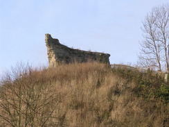
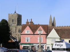
Once On the other side of the river a footpath took me uphill, from where I got some reasonable views, and once this ended at a road another footpath took me on past Claret Hall and on to another road. This led me downhill, and another footpath avoided some road walking to lead me out to the west of Clare. A footpath along the course of the old railway line took me to Clare country Park, where I had started two previous walks, and past the stunted remains of the castle and into the village. Clre is a wonderful village, and as I had made good time on the walk so far I decided to nip into a pub for a drink. Near the church I found the Bell Hotel, which I entered and ordered a pint of Rumpus.
This was a nice pint, and I soon finished it. I was tempted to order another one, but I knew that I still had a long way to walk, and so regretfully I left the inn and headed out into the village. The road took me past the beautiful church, and a footpath then led me to Castle Camps. Otherwise known as Clare Common, this is the site of the old Manor of Erbury. When the manor was demolished the area was given as grazing land to the local people by Katherine of Aragon. The area is full of little dips and hollows, and you can almost imagine what the area would have been like in the 1200's with huts on it.
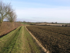
A long stretch of footpath took me on westwards, and in its exposed location led me to get extremely chilled by the wind. I was bitterly cold, and my fleece did nothing to stop the fierce gusts of wind. I was glad when the path approached Leys Farm, as this meant that the path turned to head northwards, and although I was facing into the wind it was not quite so exposed. It was whilst walking along this par of the path that I got three bad twinges from my left ankle; each one of these was enough to cause me to shout out in pain. Fortunately the pain did not last too long, but it has led me to wonder if my knee problems have caused me to alter my walking stance.
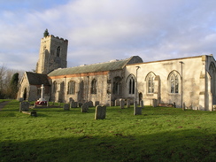
A long stretch of road walking followed, and there was little of note until I reached the village of Kedlington. The church here was open, and as I had plenty of time before it got dark I nipped in for a little walk. Inside I found a very nice church, not too grand, but with lots of fascinating little details. I wandered around oblivious to time, and regretfully left to continue along the road, which descended down to a bridge over the River Stour. This was the last time that I would see the river today, so I waved goodbye to it and continued on along the road. After crossing a main road another footpath led me uphill and into the full force of the wind once more; it was not quite as bad as before, however, and I kept myself warm enough as I walked. At Great Wilsley Farm I expected to find a trig pillar, and I looked around in a hedge of five minutes for it to no avail. When I got home I discovered that it was removed a couple of years before and placed on a rubble heap near where I was searching!
From the farm a track led me on down into Haverhill and a fairly unpleasant stroll through housing estates. Only when I crossed the A143 road and started entering the actual main part of the town did I feel Christmas cheer coming over me, and I walked past the multitude of stalls with a spring in my step. I reached the car with plenty of time to spare before dusk, and as I took my boots off I looked back on what had been a highly enjoyable stroll.
Directions
This walk starts off at the car park beside the library in Haverhill. Leave the car park and head north along a little alley to Queen Street, and then turn right,. The road passes a church on the right before becoming High Street. After a few hundred yards turn left down an alley that leads to the bus station; continue straight on, crossing the bus station, cross a stream via a bridge and then carefully cross the busy A143 road to reach a leisure centre. Head to the right of the leisure centre to reach a path that climbs uphill for a few yards to reach a path that runs along the top of an old railway embankment.
Turn right and start following the path as it heads southeastwards, before ending after a couple of miles at the B1061 road in the village of Sturmer. Turn left at this road for a few yards, and at a bend turn right to join a bridleway that heads eastwards. After a few hundred yards the bridleway turns sharply to the left; here leave the bridleway and continue straight on along a footpath that heads eastwards to a bridge over the River Stour. Here the route follows the Stour valley path, which will be followed as far as Clare. Cross the bridge and once on the other side continue along the footpath as it heads past Water Hall farm and climbs uphill to reach a road in Boyton End. Turn right along this road and follow it southwards for about a mile; eventually it ends at a junction with the A1092 road.
Continue straight on along the A1092 as it crosses the river Stour on a bridge, and then turn left to follow the road. Once it swings to the right after a few yards continue straight on through a gateway, and start waking along the driveway leading towards Baythorne hall. When the driveway curves to the right climb over a stile to the left and join a footpath that skirts a lake before continuing on eastwards along the southern bank of the river. This path skirts the grounds of Clare College before ending at a road; turn left and follow this road as it heads north past the church before reaching the A1092 road.
At the A1092 road turn right and follow it eastwards for a few hundred yards, before a footpath leads off to the right. This soon curves to the left and heads downhill to reach a driveway and an unabridged under the old railway embankment on the left. Turn right, and take a footpath that runs beside the first driveway , entering a little field before reaching a bridge over a stream. Cross this bridge, and once on the other side follow a footpath as it heads away from the river, crossing a small stream before climbing uphill. The path heads eastwards until a road is reached; turn left and then immediately right to join a track. This track leads eastwards past Claret Hall before ending at another road.
Turn left and follow this road as it heads downhill; when it reaches a T-junction with another road turn right for a few yards before taking another footpath that heads off to the left. This angles back towards the river before ending at another road. Cross this road and before the bridge is reached turn right along another footpath that follows the course of the old railway line eastwards for a couple of hundred yards before crossing a bridge over the river and entering a car park in Clare. Cross the car park and pass a building (the old goods shed, now path of Clare Country park). With the castle mound on the left continue straight on, and then take a footpath that leads off to the left that passes some toilets before ending at a road in the centre of the village.
Turn right to join the A1092 and follow it as it heads northwards. When it curves sharply to the right continue straight on along the B1063; the road curves past the church and then continues on northwards. After a short distance a footpath leads off to the left; this footpath heads into the middle of the Clare Camp complex of earthworks. Aim for the northwestern corner of the complex, and continue on westwards along a footpath. When a building is reached squeeze along the northern edge of it and then head along the footpath until just before Leys farm is reached. Here the footpath curves to the right to start heading northwards; follow it for a mile until it ends at a road.
At the road turn left and start following it as it heads westwards. After a short distance a road comes in from the left; ignore this turn and follow the original road as it curves to the right. On this bend a road leads in from the left; turn left and join this road as it heads westwards fir a couple of miles towards Brockley Green. In Brockley Green follow the road as it curves to the left past an Inn, and then to the right to regain a westerly course. The road continues on for another mile into the village of Kedlington; continue on the road through the village as it passes the church and descends down to a bridge over the River Stour for the last time on this walk.
Once the road ends at a T-junction with the B1061 cross the road and continue on along a footpath that heads uphill. This is easy to follow for about a kilometre until it ends at Great Wilsley Farm. Here turn left and join a track that heads southwestwards, descending down into a little valley before rising up on the other side and eventually ending at Chalkstone Road on the northern outskirts of Haverhill. Turn right along this road, and then take the first large road off to the left. This soon ends at Millfields Way; turn right to walk northwestwards along this road. After a few hundred yards turn left along a footpath that heads down across a little are of parkland to pass under a bridge under the railway line and reach the A143 Ehringshausen Way. Turn right along this road for a few yards and then cross the road and turn left to climb up Mount Road. When this ends at a junction turn right to follow High Street northwestwards through the centre of Haverhill. It is then a simple task to follow the road back to the car park where this walk started.
Distances
| From | To | Distance (m) | Ascent (ft) | Descent (ft) |
|---|---|---|---|---|
| Haverhill library car park | Clare car park | 9.6 | 383 | 456 |
| Clare car park | Kedlington | 5.8 | 353 | 295 |
| Kedlington | Haverhill library car park | 3.0 | 202 | 187 |
This makes a total distance of 18.4 miles, with 938 feet of ascent and 938 feet of descent.
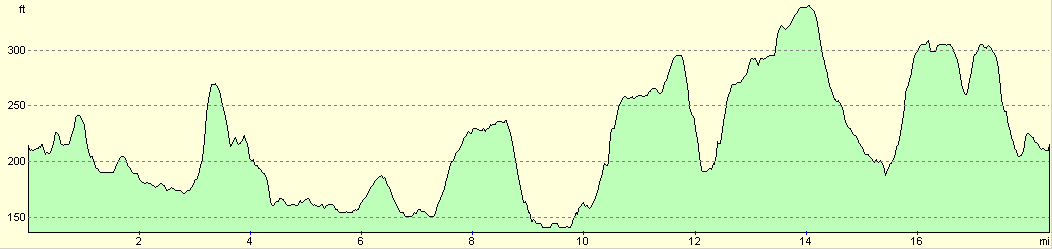
For more information on profiles, ascents and descents, see this page
Disclaimer
Please note that I take no responsibility for anything that may happen when following these directions. If you intend to follow this route, then please use the relevant maps and check the route out before you go out. As always when walking, use common sense and you should be fine.
If you find any information on any of these routes that is inaccurate, or you wish to add anything, then please email me.
All images on this site are © of the author. Any reproduction, retransmissions, or republication of all or part of any document found on this site is expressly prohibited, unless the author has explicitly granted its prior written consent to so reproduce, retransmit, or republish the material. All other rights reserved.
Although this site includes links providing convenient direct access to other Internet sites, I do not endorse, approve, certify or make warranties or representations as to the accuracy of the information on these sites.
And finally, enjoy your walking!
Nearby walks
| # | Title | Walk length (miles) |
|---|---|---|
| 105 | Newmarket to Bury St Edmunds | 21.7 |
| 220 | Linton to Newmarket | 17.3 |
| 589 | Great Shelford to Haverhill | 16.9 |
|
|

|