Walk #701: A circular walk along the Manifold Way
 |
 |
|
General Data
| Date Walked | 24/12/2005 |
| County | Staffordshire |
| Start Location | Waterhouses |
| End Location | Waterhouses |
| Start time | 08.50 |
| End time | 15.54 |
| Distance | 19.0 miles |
| Description | This was a walk of two halves; a strenuous walk over the hills northwards from Waterhouses towards Hartington was followed by a gentle, flat stroll back along the Manifold Way. |
| Pack | Today I carried my 30-litre Karrimor rucksack filled with my waterproofs, a book and various other odds and ends. |
| Condition | I had a few twinges from my left knee during the ascent up to Thor's Cave, but aside from this my knees were fine. I had worse problems with my left ankle, which ached a great deal towards he end of the walk. Aside from these problems I feel absolutely fine. |
| Weather | The day started off drizzly with low clouds, but there was little wind and so it was not too bad for walking. As the day went on the drizzle stopped and the clouds lifted, leaving a sunny day with patchy, high clouds. It was not a cold day once the clouds had lifted, and it certainly could have been far worse weather. |
| OS map | Outdoor Leisure number 24 (The Peak District - White Peak Area) |
 |
 |
|
 |
 |
|
Map of the walk
Maps courtesy of Google Maps. Route for indicative purposes only, and may have been plotted after the walk. Please let me have comments on what you think of this new format. For a detailed table of timings for this walk, please see the table file.
 |
Notes
Over the last few years I have walked most of the classic Peak District valleys, but there was one that I had not walked since my early twenties - the Manifold Valley. This was slightly strange as it is quite near to my parent's house, but perhaps that it was just too close for me to have bothered with before. Consequently I decided to do the walk this Christmas, and set about planning a suitable route, and was faced with a problem. I really wanted to avoid walking the route up to Hulme End and then walking back via the same route, so I decided that the first part of the walk would be a more westerly route over the hills beside the valley.
This meant that my knees would get a good workout, and I was concerned about whether this would cause me any problems. Putting these concerns to one side I set off from my parent's house later than I wanted, and I arrived at the car park for the Manifold Trail in good time. It cost me three pounds to park for the day, which I thought rather steep, and after using the adjacent toilets I put my boots and gaiters on and headed off down the road. The weather was not too promising - there was a persistent drizzle in the air, and visibility was so low that I could scarcely make out the factory that looms on the hillside above Waterhouses.
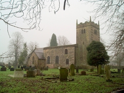
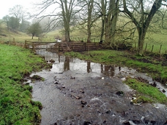
It soon became clear that mud would become a major feature of the day, as the ground underfoot was obviously wet and boggy as I climbed the slight slope along the first footpath of the day. I was glad when this soon ended at a road, Rocester Lane, and I followed this northwards. Another footpath took me past an attractive church, and a boggy path took me down to a ford through a stream at the wonderfully named Back o th Brook. As I was doing this water leaked into my left boot, showing that it had lost is waterproofing, and I squelched on up a green lane, with trees overhanging on each side as it headed steeply uphill. As the gradient slackened it proved easier to walk in the field beside the track than on the track directly, and in such a manner I soon reached a farm where tarmac restarted.
At this farm I cam across an elderly couple who were feeding some young cows with milk. I stopped to wish them a Merry Christmas, and we were soon chatting away. The man, who had a very old-fashioned moustache, and he was very depressed about the future of farming in the area. The weather was not helping, as the fields were too wet to keep the cows out, but the weather was so warm that the barns were like saunas. They were a nice couple, but when I finally walked on I did so in a slightly lower state of mind, finding myself concerned about the future stewardship of the countryside.
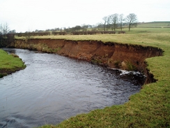
A long road walk took me north to the village of Grindon, and it was a shame that I could not get a good photograph of the church due to the surrounding trees and the drizzle in the air. A little climb and ascent took me to the start of a path, and although this was marked as a bridleway it was much more of a path. This soon led down into a little valley with a stream (Hoo Brook) running through it, and a steep path led up the other side of the valley. Another, smaller valley was crossed, before eventually diving down into a deeper one, Warslow Brook. The ascent out of this was less steep, and, after the muddy terrain, I was relieved when Villa Farm was reached and a track led me on into the village of Warslow.
The church in Warslow was quite pretty, and I took a couple of photographs of this before heading off down the road. Here I made a decision; my knees were feeling okay, and so instead of heading directly to Hulme End and the northern end of the Manifold Way I decided to make a diversion further northeastwards, to connect up with a previous walk that I had done from Hartington. A quick look on the map showed me an easy route to that walk near Townend. This involved crossing the River Manifold at a beautiful little loop in the river, and I soon found myself crossing my previous route near Townend.
A long road walk with some glorious views to the hills further south followed, and just before I reached Hulme End there was a little shop. This was a tiny affair, and the entrance was through a split stable-style door. Once inside I picked up a chocolate bar, and it was a couple of minutes before a lady came through from an adjoining room to serve me. This was charming rather than annoying, and I looked around the fascinating by cluttered interior of the shop as I waited.
A short walk along the road took me to the old railway station at Hulme End, which is now a little bike hire centre at the northern terminus of the Manifold Way. This path follows the course of the old Leek and Manifold Light Railway, which follows the Hamps and Manifold valleys from Waterhouses, where I had started the walk. The Leek and Manifold Light Railway is a famous little railway that had a shotr life - it opened in 1904 and closed in 1934, and was re-opened as a footpath two years later by the council. It had an unusual form of transhipment between the narrow gauge and the standard gauge national network - the narrow gauge wagons would carry the standard gauge wagons on top of them!
After using the toilet I headed off down the Way, which, as it is an old railway route, promised to be an easy walk. The path underfoot was surfaced and made for quick progress, although initially the views were not too astounding. As I headed south, however, the surrounding hillside crowded in and the walk became exceedingly pleasant. Surprisingly there were very few people about, and I walked on my own as I strolled along the path. Although I had extended the walk I was not too bothered about finishing before dark as the path underfoot was so good; this allowed me to take my time and not push myself too hard.
After a while the path is joined by a quiet single-lane road that the council built after the railway closed. This was a very quiet road, and at Ecton Bridge I came across a tunnel that carries the road under a little promontory. This was well lit throughout its length, and within the brick-lined walls I could clearly see into the little recesses, built to allow railway workers to take refuge from oncoming trains. No cars passed through it as a I walked, and I soon realised that the shape of the tunnel gave me a brilliant echo effect. This caused me to start shouting the usual things Hello', Echo!' etcetera, but eventually I gave a real, deep-bellied evil cackle. 'Mwwwuuuuhhhhahhhhh!' came out of my mouth, and the echo of the noise was deeply sublime. I did this again, and the deep, booming echo made me imagine that I was within some Bond villain's subterranean hideout.
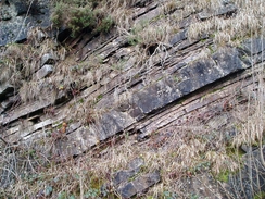
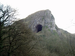
Emerging into the sunlight once more bought some sanity to my walk, and I progresses silently, hoping fervently that no-one had heard me inside the tunnel. About a mile further south near Dale Farm there was a fascinating outcrop of limestone with a couple of caves in it - a fascinating sight, but just a shade of the glory still to come. A little distance further on the road left the course of the old railway line, and a surfaced cycle path continued on. A little further distance on I got my first glimpse of the gaping chasm of Thor's Cave high up on the cliffs ahead of me, and I soon reached the bridge that carries the path up to the cave.
It was not too late in the afternoon, and so I resolved to climb up the path to the entrance to Thor's Cave. This was a fairly good path, and although steep in places stone steps, made slightly slippy by fallen leaves, led ever onwards. My left knee gave me a few twinges as I climbed, but there was nothing significant and I soon found myself standing at the entrance to the cave, looking down on an absolutely exquisite view northwards down the Manifold valley. I put my walking poles down and started scrambling up the rocky floor into the cave, the task made harder by the recent weather and the stone, polished by the passing of countless thousands of feet. Eventually I found myself inside the cave, and I saw the narrow, tall slit at the side of the cave, which precipitously falls away to the valley floor below. The whole interior is fascinating, and I half-walked, half-scrambled my way around the interior. This reminded me of a previous visit here, several years earlier, when I had entered the cave and been greeted by two climbers hanging upside down from the ceiling in a gravity-defying manner.
I was aware that I had to press on, and so reluctantly I left the interior of the cave and carefully headed down the path once more to rejoin the Manifold Way. Before I restarted along this path I looked back up at Thor's Cave, and found it hard to imagine a more majestic scene in the late afternoon sunlight. I pulled myself away from this scene, and resumed the walk along the path, heading towards Weag's Bridge and, shortly afterwards, the place where the Manifold and Hamps rivers converge.
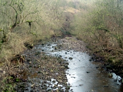
Here the Manifold Way leaves the river Manifold and starts following the River Hamps upstream. I was very surprised to see that the river bed was perfectly dry - although several rivers in the limestone part of the Peak District cease flowing in dry weather (the water goes underground through the porous limestone), I had not expected to see the river so dry after a wet autumn. By now my left ankle was starting to ache, and this got increasingly annoying as I followed the path alongside the dry riverbed. After a couple of miles, near Lee House, the water starter reappearing, and as I headed upstream it became a fully flowing river. The path kept on switching from one side of the river to the other on bridges as the river started meandering, and in such a manner I reached the A523(T) road in Waterhouses.
The path followed the road for a short distance westwards, before heading off to the left up a ramp that led back onto the old railway trackbed. The skies overhead were getting increasingly dark as I approached the car park and the terminus of the Manifold Way, but it was still fairly easy to see when I finally reached my car. As I took my boots off I could look back on what had been a good walk, and I was pleased to find that my knees had given me no significant problems.
Directions
This walk starts off at the Manifold Way car park in Waterhouses, a few yards away from the A523(T) road. Leave the car park and head down the road, away from a tall bridge, to the A523(T) road. Cross the road and then turn left to walk westwards, until a footpath leads off to the right; this footpath heads uphill to the north, slowly climbing across a field before it reaches a road near Field House Farm. Turn left and follow this road as it heads northwards; a couple of roads come in from the right before the road curves to the left to enter Waterfall.
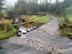
At a road junction near a phone box turn right and follow a path that skirts to the left of a house as it heads towards the church. Instead of entering the churchyard head straight on, with the churchyard on the right, and then continue on down the hill, heading for the obvious road and ford. Head slightly to the right, and before the end of the slope a hidden stile gives access to the road; use this stile and then turn left to head down to the ford across the road and on to the little hamlet of Back o' th' Brook.
On the other side of the ford the road curves to the left; here turn right along a track, and then almost immediately turn left to start climbing along a rough green lane called Slade Lane. This is easy to follow as it climbs uphill to the north, and as the gradient slackens and eventually flattens it reaches Oldfields Farm, where the track becomes surfaced. At Deepdale the track becomes a surfaced road, and this continues on northwards towards the village of Grindon.
When the road reaches Grindion turn left along another road past a pub, and then turn right for a few yards along another road, towards the church. Before the church is reached turn left to follow another road northwards, skirting to the left of the churchyard. The road descends into a little valley and climbs up the other side; when a footpath comes in from the right turn left along a bridleway that slowly descends northwards, before going steeply down to a bridge over a stream.
Cross the bridge and then turn right for a couple of yards to cross a stile, and then turn immediately to the left to start climbing uphill with a hedge on the left The road heads to the north and crosses Wetton Road, before continuing northwards. Another little valley is crossed near Kirksteads, and the way heads on, joining a driveway for a few yards before reaching another road. Immediately after this the path plunges down a rocky path to cross Warslow Brook by a bridge, and once on the other side the climb is easier as it heads uphill to end by a farm building. Here join a driveway and follow it around the buildings, and then onwards to reach a road near the church in Warslow.
Turn right for a few yards away from the church, and then continue along this road as it curves to the left. Immediately after this bend a road leads off to the right - follow this road as it heads northeastwards for about half a mile until a house called Copse Field is reached on the left. Walk past this house, and then take a footpath that leads off to the left, skirting a hedge before descending downhill to reach the B5054 road. Turn right and follow the B5054 road east for about fifty yards, and then turn left along another footpath. This immediately crosses a stream, and then join a track that heads towards a ford over a new stream and through Hollow Farm.
The track continues on northeastwards from the farm to a road, and once at this road turn right for a few yards and then left, to join another footpath that heads northeastwards down a slight slope to reach the River Manifold. Cross the river on the bridge, and the head straight on with a field boundary to the right to a small squeeze stile. Go through this stile and head uphill with a wall to the left, heading northeastwards and crossing a track before joining a track with walls on both sides that ends at a road near Townend. Turn right and head along this road for about a hundred yards until a crossroads is reached, and then turn to the right to start heading south along another road.
After about a mile this road ends at a T-junction; here turn right and start following this road as it heads westwards, passing a pub on the left before reaching a bridge over the River Manifold. Continue on westwards into the little hamlet of Hulme end, and when a green hut is reached on the left enter a car park and join the Manifold Way. Follow the way as it heads southwards for about eight miles until it reaches the A523(T) once more in Waterhouses. Here cross the road and turn right to start following the A5t23(T) westwards. After a few hundred yards take a surfaced path that leads up to the left, to join the railway embankment once more. This path continues on along the embankment for another few hundred yards until the end of the Manifold Way is reached and the car park where this walk started.
Distances
| From | To | Distance (m) | Ascent (ft) | Descent (ft) |
|---|---|---|---|---|
| Waterhouses | Warslow | 6.1 | 1142 | 899 |
| Warslow | Hulme End | 3.5 | 302 | 541 |
| Hulme End | Waterhouses | 9.4 | 1762 | 1766 |
This makes a total distance of 19.0 miles, with 3206 feet of ascent and 3206 feet of descent.
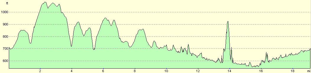
For more information on profiles, ascents and descents, see this page
Disclaimer
Please note that I take no responsibility for anything that may happen when following these directions. If you intend to follow this route, then please use the relevant maps and check the route out before you go out. As always when walking, use common sense and you should be fine.
If you find any information on any of these routes that is inaccurate, or you wish to add anything, then please email me.
All images on this site are © of the author. Any reproduction, retransmissions, or republication of all or part of any document found on this site is expressly prohibited, unless the author has explicitly granted its prior written consent to so reproduce, retransmit, or republish the material. All other rights reserved.
Although this site includes links providing convenient direct access to other Internet sites, I do not endorse, approve, certify or make warranties or representations as to the accuracy of the information on these sites.
And finally, enjoy your walking!
Nearby walks
| # | Title | Walk length (miles) |
|---|---|---|
| 14 | Friden, Long Dale and Gratton Dale | 7.8 |
| 17 | Alport circular | 11.8 |
| 22 | The Limestone Way from Matlock to Pomeroy | 16.9 |
|
|

|