Walk #686: Hope to Sheffield
 |
 |
|
General Data
| Date Walked | 07/08/2005 |
| County | Derbyshire, South Yorkshire |
| Start Location | Hope station |
| End Location | Sheffield station |
| Start time | 09.15 |
| End time | 16.22 |
| Distance | 15.5 miles |
| Description | This was a varied walk; some high and windy spots as I crossed the Peak, followed by a long road descent into the heart of Sheffield. |
| Pack | Today I carried my 30-litre Karrimor Hotrock rucksack, containing my waterproofs, a fleece, a few odds and ends such as spare batteries, my Psion 5 and two litres of water. |
| Condition | My right knee ached a great deal at times, particularly during the descents, and this was exceedingly bothersome. Fortunately my left ankle, which I twisted yesterday, did not bother me too much. Aside from this I feel physically fine, and if my knee had been okay I could have walked further. |
| Weather | The day was very similar to yesterday; cloudy with some extensive sunny periods, and a brisk wind that made the tops quite chilly. |
| OS map | Landranger number 110 (Sheffield & Huddersfield, Glossop & Holmfirth) and Landranger number 111 (Sheffield & Doncaster, Rotherham, Barnsley & Thorne) |
 |
 |
|
 |
 |
|
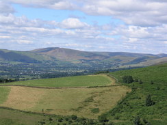
Map of the walk
Maps courtesy of Google Maps. Route for indicative purposes only, and may have been plotted after the walk. Please let me have comments on what you think of this new format. For a detailed table of timings for this walk, please see the table file.
 |
 |
|
 |
Notes
I had a rather unsettled last night in my tent; the pain from my right knee, which I twisted yesterday, was annoying whenever I moved in my sleeping bag, and the pints of alcohol that I had drunk meant that I had to go to the bathroom a couple of times. Unfortunately the lavatory block was about a hundred yards away from my tent, and the first time I made the trip it took me five minutes to get there due to the pain from my knee. When I awoke this morning I was far from confident about doing another day's walk, but I spent half an hour walking about the campsite and into Hope village, during which time my knee freed up and starting hurting less. I therefore decided to try and do a walk, and instead of doing my planned walk I chose another, less strenuous route, from Hope eastwards into the centre of Sheffield.
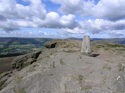
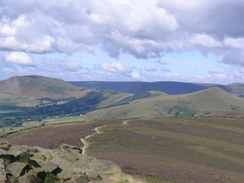
Once I had made the decision it did not take me long to pack up my rucksack and fill my water bottles, and I was soon walking to Hope Station, where I had chosen to start the walk. It was only a five minute walk, and I was quite relieved to find that my knee was not giving me too much trouble at all. From Hope I tackled a steep but enjoyable climb up to the top of Win Hill, from where I had superb 360-degree views all around me. Lose Hill and Mam Tor were clearly visible, as were Ladybower Reservoir and the entire Hope Valley, dominated by the cement works, were laid out before me. I had only been up Win Hill once before during low cloud last year, and it was enjoyable to be able to be at the summit in far clearer weather. The summit itself is a rocky, craggy affair, and has an air of desolation that is uncommon amongst other hills in the area. I lapped up the experience of being at the top, and only started to descend once the brisk wind started to make me feel chilly.
My plan was to descend down to Yorkshire Bridge over the River Derwent, and to do so I had to descend all of the height that I had gained during the climb of Win Hill. The descent started off gradually as I descended the bare flank of the hill, but it soon entered a wooded area, where it started to increase in steepness. Eventually the way down beside Parkin Clough became a stony, narrow path, the going hard on patches of steps that were generally of uneven height. My right knee started to protest at the strain that it was undergoing, and this made the descent even more difficult. About halfway down I came across a group of about twelve people making their way up the path, and I stepped to one side to allow them to pass - there were not that many places where this was possible on the rough, narrow path. The descent seemed to take forever, and my right knee was hurting by the time the path suddenly ended at a road at a track at the bottom. I almost fell over the final stile onto this, and walked the few yards to Yorkshire Bridge, where I stopped, pausing to take a rest after the surprisingly tiring descent, and watched the waters of the River Derwent flow underneath.
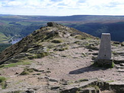
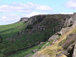
For a few minutes I considered abandoning the day's walk at Bamford, just up the hill from the river, and getting a bus and train back to Hope, but as I ascended the hill I realised that my knee was not hurting too much on the ascents, and it was only the descents that was causing it bother. I therefore crossed the A6013, and started following a quiet road that led up towards Bamford Edge. The good surface underfoot allowed me to make good time, and I was soon on the less steep part of the ascent near the edge, where I came across a local couple out walking. We stopped to chat, and after an invigorating conversation I started off once again along the road. The vies across the moorland were good, but what really exhilarated me were the views ahead of the sheer rock escarpment of Stanage. The Dennis Knoll car park was soon reached and I started walking along the rough track that headed up to the top of the escarpment. As I did so four trail bikers passed me and one of these went straight through a muddy puddle beside me, showering me with dirt and water. Some of this even got into my mouth, and as I continued climbing up to the top of the edge I could feel the grit between my teeth.
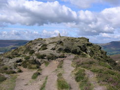
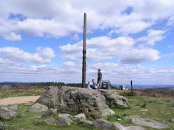
The scenery was such that I could not really be too annoyed, with the large, sculptured boulders looming above me to my left as the track climbed up to the top. At the top there were a group of land rovers who were obviously off-roading, adding to the erosion on the tracks in the area. They seemed a jovial crowd, and I squeezed past the off-roaders and plodded on, away from the edge eastwards to Stanage Pole. On the way the land rovers came carefully past me, and I soon arrived at the iron-clad pole, which marks the boundary between Derbyshire and South Yorkshire, and is also on the old Roman road to Sheffield that also passes Hope Cross near Win Hill. The pole (although replaced many times) has been in existence since at least 1550, and must have seen literally hundreds of thousands of travellers pass the weathered rocks at its base. There were a few people around the pole, and as I wanted some photos of it with no-one about, I decided to stop for lunch. A few minutes after I did so the people departed, and I took a few photos whilst I had the opportunity. Fairly soon the pole was heaving with people once more, and I sat down and just cast my eyes around the surrounding superb moorland.
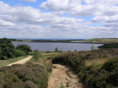
Eventually I could not wait around any longer, and I started following the track that headed downhill northeastwards towards the first of the Redmires reservoirs. There were some pleasant views across the reservoirs, and I let my eyes roam across these as I crossed a section of exceedingly muddy track, after which the tarmac of the road proper began. From here until the end of the walk I was going to be following roads, but nonetheless I found the next stretch of walk past the three reservoirs to be quite fulfilling. Once the reservoirs ended the walk became more boring, and I walked down into Lodge Moor (where there had been a large prisoner of war camp during World War Two). A pub was marked on the map, and when I reached The Three Merry Lads I could not help but nip in for a drink. I purchased a pack of crisps, a beer and a pint of water, and went to sit outside, where it was sunny although chilly in the wind. After five minutes a gentleman sat down on the bench opposite me; he was on a local bike ride, and we ended up chatting for well over half an hour, He was a fascinating character, but eventually I had to drag myself away as I knew I had much walking left to do.
The rest of the walk into Sheffield was fairly straight forwards, and the outskirts of Sheffield flew by until I started approaching the outskirts of Sheffield. I had not been to the city for years, and I was pleased by the sight of some of the new architecture in the city, as what I remembered as being a grey city was now enlivened by gleaming steel and glass buildings, which the architects had avoided the common by sculpting them into flowing, artistic shapes. Many of these buildings belonged to the university, and as I passed the Sheffield super tram route I was once again into a slightly dreary area.
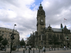
My planned route took me into the centre of the city, and in the centre I came across an absolute gem of a building - the Town Hall, which is a fantastic stone structure that was a marked contrast to the modernistic buildings I had been passing twenty minutes before. The detail on the stonework was brilliant, and I studied that as I walked past and headed downhill towards the station. I remembered the area around Sheffield Station as being quite ugly, and I was glad to see that there were large works in progress to remedy this. Hopefully this will make the area around the station a fitting gateway into this vibrant city. Once at the station little remained to be done except to buy a ticket and wait for my train back - I was relieved at having finished the walk, but I was annoyed that ,my right knee had ached at times during the walk.
Directions
This walk starts off at Hope railway station. From the entrance to the station, go onto the platform and cross the footbridge to reach the Sheffield-bound platform. From here leave the platform via a footpath. This crosses a field to the north, and follows a series of field boundaries on the way. When it ends at a road, continue straight on along the driveway that leads up towards Edge farm. At Edge Farm, turn left, and take a rough track with overhanging trees that heads uphill to the northwest. The track ends and emerges into a field; continue along with a boundary to the left, before turning right along another footpath that heads uphill to the northeast. The path is easy to follow as it heads steeply uphill, and when it reaches the top of Thornhill Brink turn right to follow another footpath that leads to the top of the craggy Win Hill.
From the windswept summit head east, joining a footpath that descends down into Winhill plantation; the path is steep but relatively easy until it comes across a crossroads with another path; after this it plunges into the forest. The route I took was down an obvious footpath that heads down the northern side of Parkin clough; this was exceptionally steep and rough, with there sometimes being rough stone steps leading down. It was hard going with a dodgy knee, and in the wet or in icy conditions extra care should be taken. The path came out on a private road; turn right for a few yards through a gate, and then turn left to cross the River Derwent at Yorkshire Bridge.
From the bridge continue on along the road as it heads eastwards uphill, passing houses before reaching the A6013. Turn left along the A6013 north for a few yards, and then turn right to start heading southeastwards along a road. This road climbs steeply uphill, passing the southern end of Bamford Edge before dropping and climbing uphill once more over Bole Hill. A road comes in from the right, and shortly afterwards Dennis Knoll car park is reached on the left. Enter the car park, and then continue straight out along a track that starts to head uphill. He track soon passes some woodland on the right, and then curves around to the right and climbs uphill more steeply, before eventually reaching the top of Stanage Edge.
Do not join the path along the edge, and instead keep on the track as it heads eastwards across the moors to Stanage Pole. Keep on the track as it starts to head downhill, eventually becoming a surfaced road by the Upper Redmires reservoir. The road skirts around the western end northern edges of the reservoir, before heading downhill, passing the northern edges of the middle and lower reservoirs. Continue on along this road as it heads in a rough easterly direction, passing through Lodge Moor and on into the outskirts of Sheffield. The road eventually ends at a junction with the A57; at this point turn right and start following the A57 as it heads southeastwards through Tapton Hill. It curves to the left to head east, and, whilst lowering in height all the way, turns to the left once more to head northeastwards to meet the A61 at a large roundabout. Cross the roundabout and continue on along the A57until another roundabout is reached. Here turn right and climb uphill along Town Street, and when this curves to the left head straight on aiming for Leopard Street, which leads on towards the Town Hall in the centre of the city.
At the Town Hall turn left and start following Surrey Street as it heads downhill. When this ends at the A621 road, turn right along the A621 for a short distance, and then turn to the left to head southeastwards long a road that leads to the A61.; Sheffield railway station is straight ahead beside the A61.
Distances
| From | To | Distance (m) | Ascent (ft) | Descent (ft) |
|---|---|---|---|---|
| Hope station | Stanage Pole | 6.8 | 2382 | 1499 |
| Stanage Pole | Sheffield station | 8.7 | 299 | 1565 |
This makes a total distance of 15.5 miles, with 2681 feet of ascent and 3064 feet of descent.
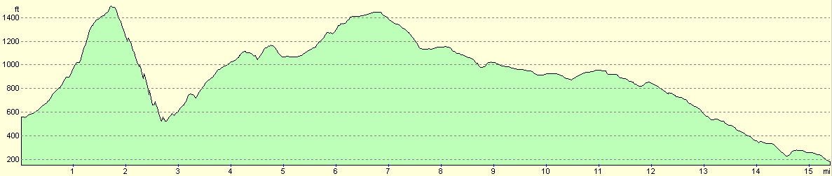
For more information on profiles, ascents and descents, see this page
Transport
There are regular train services running from Sheffield to Hope via the Hope Valley Railway Line. There are also regular bus services running from Sheffield into the village, one of which stops right outside the campsite that I stayed at.
Accommodation
I spent the night at the Laneside Caravan Site, Laneside, Hope, S30 2RR. Telephone (01433) 620215. This was a well-appointed site, an easy stagger away from the pubs in the village. It cost me nineteen ponds for the two nights that I stayed; eleven pounds for the Saturday night, and eight pounds fifty for the Sunday night.
Disclaimer
Please note that I take no responsibility for anything that may happen when following these directions. If you intend to follow this route, then please use the relevant maps and check the route out before you go out. As always when walking, use common sense and you should be fine.
If you find any information on any of these routes that is inaccurate, or you wish to add anything, then please email me.
All images on this site are © of the author. Any reproduction, retransmissions, or republication of all or part of any document found on this site is expressly prohibited, unless the author has explicitly granted its prior written consent to so reproduce, retransmit, or republish the material. All other rights reserved.
Although this site includes links providing convenient direct access to other Internet sites, I do not endorse, approve, certify or make warranties or representations as to the accuracy of the information on these sites.
And finally, enjoy your walking!
Nearby walks
| # | Title | Walk length (miles) |
|---|---|---|
| 13 | Edale and Kinder Scout | 11.0 |
| 19 | Castleton circular via Lose Hill and Mam Tor | 7.7 |
| 23 | The Limestone Way from Pomeroy to Castleton | 14.0 |
|
|

|