Walk #940: Edale to Kinder, Brown Knoll, Rushup Edge and Mam Tor
 |
 |
|
General Data
| Date Walked | 16/11/2011 |
| County | Derbyshire |
| Start Location | Edale Fieldhead campsite |
| End Location | Edale Fieldhead campsite |
| Start time | 07.35 |
| End time | 15.17 |
| Distance | 17.7 miles |
| Description | This was a pleasant walk following the Pennine Way onto Kinder Scout and along the western edges, before returning over Brown Knoll to Rushup Edge, Mam Tor and Hollins Cross before descending down to Edale. |
| Pack | Today I carried my 30-litre Karrimor rucksack, filled with water, my waterproofs, a book and other odds and ends. |
| Condition | I feel fine after this walk, with no problems to report. |
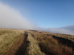
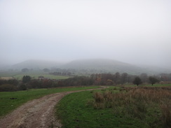
| Weather | Today's weather was rather grey to start off with, but the clouds were left behind during the climb and the top of Kinder was bathed in sunshine. Sadly the walk all the way from Edale Rocks to Hollins Cross was in cloud. |
| OS map | Outdoor Leisure number 1 (The Peak District - Dark Peak Area) |
 |
 |
|
Map of the walk
Maps courtesy of Google Maps. Route for indicative purposes only, and may have been plotted after the walk. Please let me have comments on what you think of this new format. For a detailed table of timings for this walk, please see the table file.
 |
 |
|
Notes
My plan for today was to set off from the campsite in Edale and walk the Pennine Way to the Snake Pass, before returning by the same route. Sadly the weather was poorer than forecast with a curtain of low cloud hanging overhead. The radio reported that the railway line was shut due to a freight train derailment, but I could clearly see both passenger and freight trains trundling past the campsite.
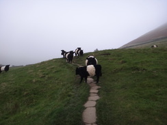
I knew the first part of the walk well; head up the road to the Old Nag's Head, which is the official start point of the trail, then take a path that climbs over the hillside to reach the hamlet of Upper Booth. The views were none too grand on what was a cloudy, grey day, and even the cows that blocked the path seemed none too pleased with the weather. The ascent was across stone slabs that certainly seem to have protected the grass of the field, although the descent on the other side was unpaved.
I could not help but think back to when I was walking this stretch of path twelve years before as part of my walk along the Pennine Way. That had been my first national trail, and my nervousness was making me feel sick. This nauseous feeling lasted all the way over Kinder, and I only started to feel better once I reached the ascent onto Bleaklow. It seems ridiculous that nerves effected me in that manner, but I am so much more experienced at walking now.
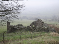
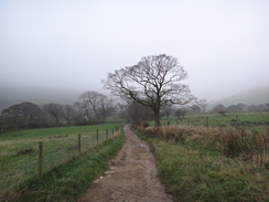
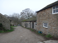
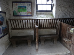
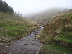
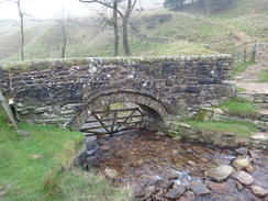
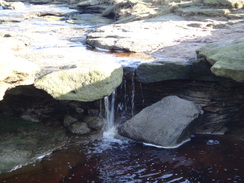
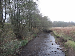
There were no such problems today as the path descended down to reach Upper Booth before climbing along a track to reach Lee Farm. An old byre has been converted into an information hut and shelter, although the interior today was dark and sadly unwelcoming. Another track continued uphill from the farm until an exceedingly narrow packhorse bridge is reached over a stream. This is the first truly scenic spot on the Pennine Way and is well worth a little exploration. I went off the track to take some photos of the stream burbling underneath the arch, although the gloomy weather would have spoilt these somewhat.
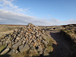
The bridge marks the start of Jacob's Ladder, a steep path that leads onto the southeastern corner of the Kinder Scout massif. It was a steep climb although was not hard due to the stones that had been laid out to form steps. As these were uneven it was easy to find a stone that matched my natural step height and I was soon climbing into the cloud. The gradient slackened at a cairn although the path continued inexorably upwards. I was reminded of a story my grandfather told me of when he and a friend cycled from their homes in Derby to Edale in the 1930s, shortly after the Kinder mass trespass. They pushed their tandem up Jacob's Ladder before the stones had been laid, taking two steps back through the mud for every one up. The descent had been easier and they had made their way down to Manchester for the night before returning via the A6 on the Sunday. Perhaps I got my love for the outdoors from him...
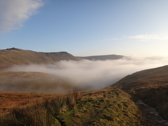
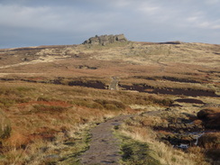
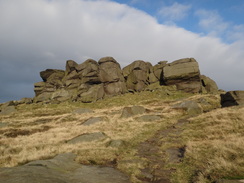
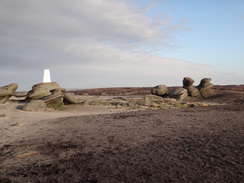
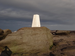
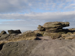
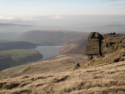
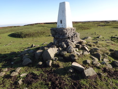
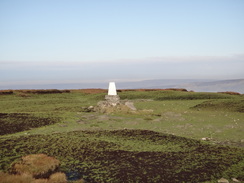
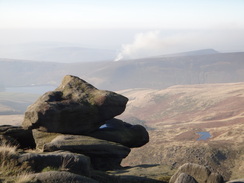
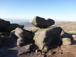
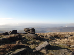
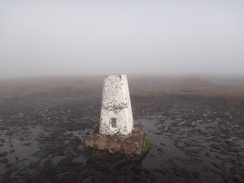
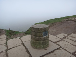
I was surprised to find that visibility was improving, and a glance behind showed a white fluffy sheet of cloud settled in the valley with the edges of Kinder bathed in bright sunshine. It was a good omen and soon I was climbing north past the rocky outcrops of the Swine's Back and Edale Rocks. I was ecstatic at finding sunshine when I had expected cloud and soon I diverted off the path to reach the trig pillar on Kinder Low. This has been brightly whitewashed and stood prominent on top of a large wind-sculpted boulder.
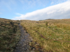
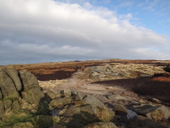
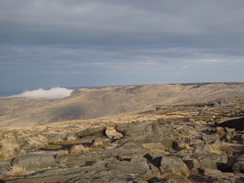
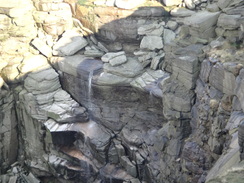
The path north was along classic Kinder terrain, with rocky outcrops and grand views down towards the reservoir below. There were some boggy bits but mostly it was rocky, with the path splitting and rejoining frequently. It crossed one small valley and then, a mile later, reached the infamous Kinder Downfall. The flow was minimal and the wind in the wrong direction to create the classic blown-water effect that the downfall is famous for. I did not tarry in crossing the river and continuing northwestwards along the edge.
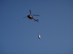
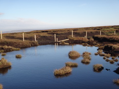
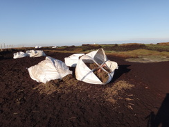
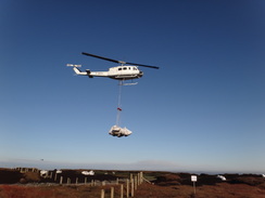
A black helicopter was flying to and fro with a skip suspended underneath it; this was level and presumably filled when flying towards Kinder, and hanging at one end and empty when returning towards civilisation. I later learnt that the helicopter was tipping lime over the landscape to mitigate the effects of acid rain that has devastated the vegetation on the hills. More work was also visible around, including a new fence to keep grazing animals off the new grassland.
As I approached the descent down to Mill Hill I decided to change my plans. The valley below was wreathed in cloud and there would not be many opportunities for taking photos; I therefore decided to head back and extend the walk around Brown Knoll and Rushup Edge. On the way back I met a man called Steve Holmes. He was carrying a heavily-loaded pack and was just embarking on a winter trip along the Pennine Way for a charity called Save our Sue'. He had glorious weather for the start although I would find a winter walk rather wearying, if only for the long nights spent alone in a tent. I wished him the best of luck and continued on.
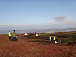
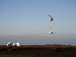
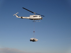
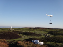
Soon I decided to divert off the path to reach a trig pillar. A new fence had to be negotiated - part of the scheme to revegetate the hillside - and I passed several men in high-viz jackets who were standing around. A large white helicopter flew repeatedly overhead, dropping white bags filled with chopped heather onto the ground. Watching it fly low overhead was fantastic, especially the way the bags swung like a pendulum before they were dropped. At times I felt like I was in a war film.
I stopped off for a short break at Kinder Downfall, and so far the Pennine Way walker was the only person I had seen all day. That soon changed as a series of people came past: runners, walkers and even a couple of cyclists. The weather was beautiful and the going easy; I was in heaven as I left the helicopters well behind.
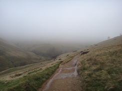
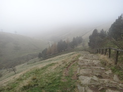
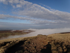
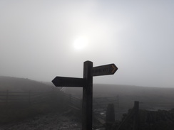
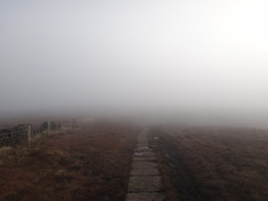
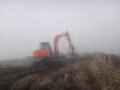
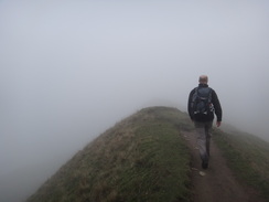
My new plan came unstuck as I approached Kinder Low. Mist was starting to rise from the peat haggs, and this thickened as the path descended past the Swine's Back. All too soon I was fully wreathed inside a cloud layer. I was tempted to just head back to Edale, but that would have meant wasting several hours that could be more profitably spent on the hills. Instead I decided to continue across to the trig pillar at Brown Knoll. Paving slabs took me across the hill; these had obviously been freshly laid and the ground between had been churned up by tracked vehicles. Soon a couple of diggers came into sight, one of which had a forked attachment for lifting the slabs. Somehow the digger drivers saw me approaching through the fog and stopped whilst I passed.
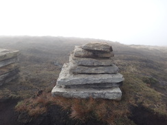
Slabs were piled up ready to be laid into a trench had been dug ready to accept them. It would have looked awful in good weather, but in the mist the trench proved a useful navigation aid. Every instinct told me that I had to head over the fence to the left but the slabs led inexorably on down a slight slope. I passed a stile on the left, then backtracked for a few yards when I realised that the slabs were leading in the wrong direction.
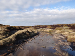
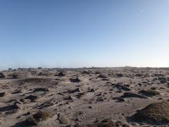
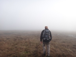
The ground leading towards the trig pillar on Brown Knoll was boggy and the visibility was awful, yet somehow I managed to head straight for the pillar. This was sitting in a morass of mud and for once I decided not to attempt to visit the pillar and instead stared at it from across the sea of mud. Onwards navigation looked difficult; I had to head southeastwards but the terrain was not easy, with channels and boggy sections that had to be negotiated. I was about to get my compass out to take a bearing when a figure emerged from the mist. His name was Andy and he was heading in the same direction; I decided to keep things simple and just follow him.
We chatted as we headed down off the hill; this was made more difficult by the fact that we often had to part to jump across various streams and bogs. In sunny weather this would have been a joy, but in the mist it was not much fun. The company was pleasurable, even if Andy was setting a rather faster pace than my usual amble. He soon told me the reason: he has run mountain marathons in the past! The miles flew by; we soon joined the track at the western end of Rushup Edge and headed up towards Lord's Seat. The stroll along the sharp-edged ridge is usually spectacular, but today it was hard to see anything through the cloud. Annoyingly we were not too far from the top of the cloud layer and occasional glimpses of blue sky could be seen, but this never lasted for long.
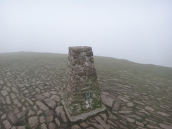
We descended down to meet a road, then climbed up a large set of steps to reach the trig pillar at the top of Mam Tor. This too was wreathed in cloud and we did not spend long before starting the descent down towards Hollins Cross. Before I knew it we were there and descending back towards Edale. I said goodbye to Andy at the car park and then headed over to the campsite; tired but overjoyed at an enjoyable walk despite the rather grim weather.
 |
 |
|
Directions
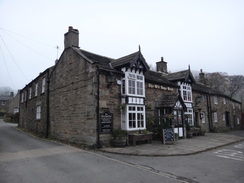
This walk starts off at the Fairfield camping site in Edale at SK123856. (It is equally possible to start the walk at the main car park in Edale; to do this simple leave the car park by the pedestrian access near the public toilets and turn right up the road. Pass the railway station on the left and pass under a railway bridge. The road soon passes a pub on the left before reaching the entrance to the caravan site on the right). Leave the campsite by the main entrance and turn right to follow a road uphill for a quarter of a mile, passing the church on the left before reaching the Old Nag's Head pub in Edale at SK122859.
The pub marks the southern trailhead of the Pennine Way, and the first half of this walk will follow that trail. At the pub turn left along a path that immediately crosses a stile with a house to the left. Continue on to an open gateway and head on along a sunken lane with a stream to the right. This leads to a pedestrian gate; continue with a fence on the left to a few stone steps and another pedestrian gate. Go through this and take the obvious path along stone slabs across a field.
The path climbs across the field to reach a pedestrian gate through a stone wall. The slabs continue across a field on the other side to another pedestrian gate through a stone wall that leads into a third field. The path climbs; at the top of the field go through another gate and cross a slightly boggy area. The path continues climbing to reach some steps up to another pedestrian gate. Go through this; the slabs soon end and a broad path continues to a fifth pedestrian gate. The rough ground continues as the path heads to a sixth gate; finally the path crests a small hill and starts falling to a seventh gate.
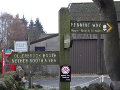
Go through this and follow the path as it continues falling with a fence on the left. Eventually it leaves the fence behind and angles towards a gate at the bottom of the field. On the other side the path crosses a tumbledown wall and heads diagonally across another field. At the end of the field the path crosses a small ditch and passes two stone posts; it then curves to the left to enter another field. Aim for a pedestrian gate at the bottom right-hand corner of the field; this leads onto a track that heads westwards between stone walls. At the end of the track go through a pedestrian gate beside a field gate. Turn left down another track and follow this as it curves to the right. Cross a stile beside a field gate to enter a farmyard. The track emerges out onto a public road in Upper Booth at SK102852.
Turn right to follow the road; initially it descends to cross Crowden Brook on a bridge before climbing up the other side. Go through a pedestrian gate beside a field gate and continue along the track. 0.4 miles after Upper Booth it passes through Lee House Farm. The road becomes a track just before the farm; follow this through the farm and then past a field gate. Continue along the track as it climbs northwestwards, crossing a couple of stiles beside field gates before curving to the right to reach the packhorse bridge over a stream at SK088861.
Go through a field gate and then turn left to cross the packhorse bridge. On the western side turn half-right to start climbing up a steep set of stone steps called Jacob's Ladder. The gradient slackens slightly and the stones end; the path becomes rougher as it continues climbing to reach a large cairn. At the cairn turn right to continue climbing alongside a fence on the left. Eventually the gradient slackens and a stony path heads on uphill, soon joining stone slabs. When a path junction is reached at SK080861 turn right to head uphill along a path that heads northwards, aiming for the eastern edge of a large line of rocks called the Swine's Back. Pass the rocks and continue in roughly the same direction. Head for a little cairn nestled amongst rocks on the skyline ahead.
Soon Kinder Low trig pillar becomes visible off to the right; you can visit this if you so wish. Navigation is easy from here on; simply keep the western edge of Kinder to the left. The path regularly splits and rejoins as it heads east-northeastwards; after two-thirds of a mile it reaches Red Brook at SK080879. Cross the stream and continue on for another 0.6 miles until the River Kinder is reached at SK082889. If there has not been much rain then the river is easy to cross at the top of the waterfall known as Kinder Downfall; in wet weather you may have to walk further upstream to find a safe spot.
Cross the river and continue northwestwards along the edge, with grand views available over Kinder Reservoir down to the left. Head on for 1.3 miles towards the northwestern corner of Kinder; the path starts to fall down towards Mill Hill. At SK076891 the path crosses a stile over a fence. At about SK066898 I turned around and started heading back onto Kinder. The route is simple; just keep the edge of Kinder to the right as you return to Kinder Downfall, Red Brook, Kinder Low and finally the Swine's Back. A worthwhile diversion can be made to visit a trig pillar at SK076893 to the northwest of Kinder Downfall, which unusually has an older trig pillar lying recumbrant on the ground beside it.
Make your way back to pass the eastern edge of the Swine's Back at SK079863. Continue downhill, but as the Pennine Way turns to the left continue on to reach a stone wall at SK080861. Here turn right through a gateway through the wall and start following a slabbed path southeastwards across the moorland, with a stone wall off to the left
After a short distance the path curves to take a more southerly course, before turning to the left and crossing a stile at SK081852. On the other side heading southeastwards across the moorland to the trig point on Brown Knoll at SK083851; care needs taking and compass navigation may be necessary in bad weather. The path then continues southeastwards across the moorland, which is very boggy in places. It soon curves to take a more south-southeasterly direction; after 1.5 miles it reaches a junction with the Chapel Gate track at SK098831.
Turn right and follow the Chapel Gate track south for a few hundred yards until it reaches a T-junction with another track at SK099829. At this junction turn left and follow a path as it heads eastwards, starting the 0.9-mile climb up to the summit of Rushup Edge at Lord's Seat. From Lord's Seat the path descends eastwards for 0.8 miles, becoming increasingly narrow as it descends. At the end a short but steep descent leads down to a road at Mam Nick at SK124834.
From Mam Nick turn right along the road for a few metres and then left to start the climb up stone steps towards the summit of Mam Tor. Once the trig point on Mam Tor is reached start the descent down a path of stone slabs to the north; the path is obvious as it heads downhill. The stone slabs end just before a little stone cairn is reached at Hollins Cross (SK136845). Here turn left and descend steeply down a path to the northwest, which passes the farm at Hollins before joining a track near Peter Barn. The track heads north-northwestwards, crossing the River Noe just before it ends at a road.
Turn left and follow the road westwards, crossing Yeomans Bridge before reaching the car park in Edale on the right. Shortly after this a road leads off to the right; follow this and as it swings to the left towards the railway station, continue straight on along anther road that leads past an inn on the left to reach the Fieldhead campsite, where this walk ends.
 |
 |
|
Distances
| From | To | Distance (m) | Ascent (ft) | Descent (ft) |
|---|---|---|---|---|
| Edale | The Edge | 7.1 | 2028 | 981 |
| The Edge | Rushup Edge | 6.4 | 843 | 1083 |
| Rushup Edge | Edale | 4.2 | 535 | 1342 |
This makes a total distance of 17.7 miles, with 3406 feet of ascent and 3406 feet of descent.
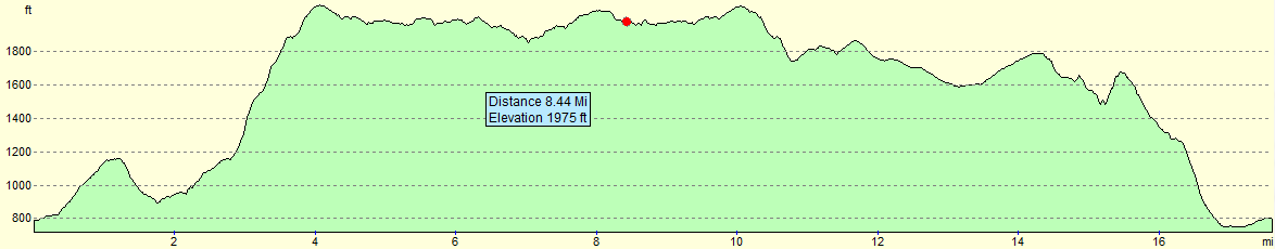
For more information on profiles, ascents and descents, see this page
Accommodation
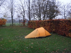
I spent the night at the Fieldhead Campsite in Edale, which is conveniently placed for both of the pubs in the village. It cost me five pounds for the pitch and another three pounds for the car, and the water was nice and warm considering it was November. Not a bad place to spend a night.
 |
 |
|
 |
 |
|
 |
 |
|
 |
 |
|
 |
 |
|
 |
 |
|
 |
 |
|
 |
 |
|
 |
 |
|
 |
 |
|
 |
 |
|
 |
 |
|
 |
 |
|
 |
 |
|
 |
 |
|
 |
 |
|
 |
 |
|
 |
 |
|
 |
 |
|
 |
 |
|
 |
 |
|
 |
 |
|
 |
 |
|
 |
 |
|
 |
Disclaimer
Please note that I take no responsibility for anything that may happen when following these directions. If you intend to follow this route, then please use the relevant maps and check the route out before you go out. As always when walking, use common sense and you should be fine.
If you find any information on any of these routes that is inaccurate, or you wish to add anything, then please email me.
All images on this site are © of the author. Any reproduction, retransmissions, or republication of all or part of any document found on this site is expressly prohibited, unless the author has explicitly granted its prior written consent to so reproduce, retransmit, or republish the material. All other rights reserved.
Although this site includes links providing convenient direct access to other Internet sites, I do not endorse, approve, certify or make warranties or representations as to the accuracy of the information on these sites.
And finally, enjoy your walking!
Nearby walks
| # | Title | Walk length (miles) |
|---|---|---|
| 13 | Edale and Kinder Scout | 11.0 |
| 19 | Castleton circular via Lose Hill and Mam Tor | 7.7 |
| 23 | The Limestone Way from Pomeroy to Castleton | 14.0 |
|
|

|