Walk #687: A circular walk from Marsden to Black Hill
 |
 |
|
General Data
| Date Walked | 08/08/2005 |
| County | South Yorkshire, Derbyshire, Greater Manchester |
| Start Location | Marsden station |
| End Location | Marsden station |
| Start time | 08.38 |
| End time | 14.26 |
| Distance | 13.5 miles |
| Description | This was a superb walk, taking in parts of the Pennine Way and the old route of the Pennine Way off Black Hill. |
| Pack | Today I carried my 30-litre Karrimor Hotrock rucksack, containing my waterproofs, a fleece, a few odds and ends such as spare batteries, my Psion 5 and two litres of water. |
| Condition | Again my right knee gave me trouble today, and during the long slog downhill the pain became quite severe. Aside from this I felt fine, and I did not find the long climb to be too tiring. |
| Weather | The weather today was sunnier than the last couple of days had been, with only occasional cloudy periods. The wind was again quite strong, and quite chilling at the top of Black Hill. |
| OS map | Landranger number 110 (Sheffield & Huddersfield, Glossop & Holmfirth) |
 |
 |
|
 |
 |
|
Map of the walk
Maps courtesy of Google Maps. Route for indicative purposes only, and may have been plotted after the walk. Please let me have comments on what you think of this new format. For a detailed table of timings for this walk, please see the table file.
 |
 |
|
 |
 |
|
Notes
I awoke this morning with my right knee still very sore after the injury I suffered on Saturday. I got u to do my ablutions whilst the sun was still low in the sky, and I took my time, waiting for the gates to the campsite to open at seven in the morning. As it was my tent was very wet with dew, and so I left it out in the early morning sunshine for a while, trying to get rid of the worst of the dew. B y about seven thirty it was obvious that it was not going to get any better soon, so I put the tent loosely in the back of my car, filled up my water bottles and packed up the rest of my kit. The drive to Marsden took me much longer than I was expecting, although the early morning drive over the Snake Pass was quite exhilarating.
It was quite hard to find a place to park at Marsden station, hemmed in as it was by the adjacent road bridge and the locks of the Huddersfield Narrow Canal. Eventually I found a position right by the station by pulling my car fully into the verge beside a wall, parked tight between two other cars. It then took me only a few minutes to get my gear together, and I started heading off down the road towards the centre of town, stopping only to have a quick look at the exceedingly narrow lock on the canal. I was tempted to divert off route slightly to see the eastern portal of the Standedge canal tunnel - the highest, deepest and, at three and half miles, longest canal tunnel in Britain. It was a bit of a stroll to the entrance, however, and so I decided to continue on the walk.
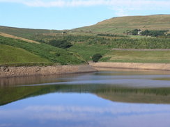
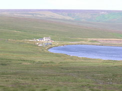
Marsden is a typical Pennine mill town - once it had many mills, but despite this it appeared a bright, cheerful place as I walked through it in the sunshine. I stopped off at a shop where I bought some chocolate and chatted to the lovely Asian lady who was serving behind the counter. Once IO left I started following the Kirklees Way as it followed a road uphill, passing the mill and a row of mill houses with classic staggered rooflines. It was a superb morning, and I found myself loving the walk, despite an occasional twinge from my knee. I soon reached the dam of Butterley reservoir, and was greeted by a superb view across the surface of the water, which was quite flat and gleaming blue with reflected sky. The track underfoot was wide and good, and I made good time, excepting short steps to admire the views over the reservoir) to the dam of the far smaller Blakeley Reservoir.
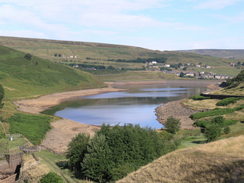
The water levels in this reservoir were quite low, exposing large areas of stony foreshore and foreshortening the already small reservoir. A little climb along the good track took me up to the dam of the larger Wessenden Reservoir, where I joined the route of the Pennine Way. It was easy for me to recall the last time that I had walked past the dam, on my Pennine Way walk seven years ago; I was tired, frustrated and fed up with what seemed to be a never-ending descent from the top of Black Hill. Remembering this amused me as I was feeling very different today, my mood soaring as I walked along the track, which reduced in width as it headed up towards Wessenden Head reservoir. As I walked I listened to Radio 5, who were discussing whether or not the Space Shuttle would be landing today.
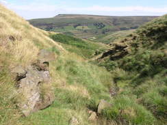
The answer came when I reached the A635 road; the shuttle would have to spend another day in orbit due to bad weather at Kennedy. Pondering this, I crossed the road, and was disappointed to find that Snoopy's snack van that is sometimes parked there was not present. There used to be a pub at the road in this location, but it was demolished due to worries about polluting the reservoirs downstream. I plodded on along the Pennine Way, and for the first time in the day I was following paths rather than tracks. The Way dipped into a Couple of gullies before reaching a deeper one; here I met a foreign couple who were walking the Way; they had started at Crowden this morning, and were considering getting to Mankinholes this evening. That is a long walk, and I wished them all he best as I continued plodding on along the long path that lead sup onto Black Hill.
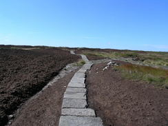
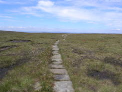
Black Hill is famous as being a quagmire that more than amply lives up to its dark name. However on none of the occasions I have been up here have I found it to be too boggy; the ground always seems firm. Since I first came up here in 1999 flagstones have been laid over the worst section to and from the trig pillar; this has tamed the hill even more, and it makes the walk pleasant if slightly more boring. I really am fascinated by the peat plateaus of Derbyshire; the differences in colours between the dark browns and blacks of the peat, the reds and greens of the heather and the blue of the sky on a summer's day are truly enticing.
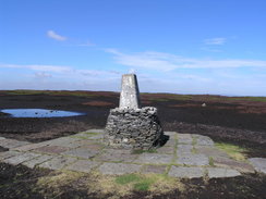
I decided to sit down and have a rest at the trig pillar, and so I put my rucksack in the lee of the trig pillar to protect myself form the brisk wind and sat down. Soon a runner came along, and we chatted for a while; he often runs up here, and he had done it in from Marsden in a short period that made my progress look plodding and ponderous. He said goodbye and departed, and soon afterwards another walker came along, looking tired and out of breath from the steep climb out of Crowden. He turned out to be another Pennine Way walker, and his nervousness and fatigue reminded me of how I must have been six years ago when I was in his place. He was keen to move on, and after he departed I walked around the area for a while, studying the moonscape that surrounds the trig pillar.
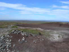
Eventually the wind started to get to me, and I hefted my rucksack onto my back and started taking the path that heads northwestwards off the hill. This is the course of the old Pennine Way before it was rerouted via Wessenden Head, and it is a far bleaker walk. Small cairns led me over the peat plateau, before descending and rising up to Dean Head Hill. The going underfoot was rough but nowhere near the worst that I have ever known, and although the path was in places indistinct, I found it relatively easy to keep heading in the correct direction as I walked. Behind me the Holme Moss transmitter was always visible, and this route would be much easier to walk in the opposite direction, as the path heads virtually directly towards the mast.
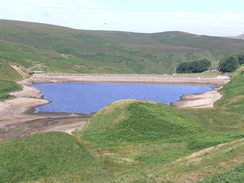
The path met the A635 road, which I found to be under repair. I followed it westwards for a few yards to a small lay-by, which was nearly fully covered with large hills of road chippings. A path led on, still continuing northwestwards across White Moss. Although there was a good path for about half a mile as it cross the moor, which showed signs of being restored, with large bails sitting in the watercourses, designed to stop the peat being washed down the channels. Unfortunately at a deep dike the path more or less vanished, and I was left struggling across a wonderful stretch of moorland, which was hard work but very rewarding. It was at this time that my right knee started hurting more insistently, and although this was not too painful I was still concerned, particularly after the trouble it had given me over the last couple of days. I was relieved when the path became more distinct underfoot, and I soon found myself walking towards the blue, clear water of Black Moss Reservoir. After passing a rather foreboding MOD sign (there is a military shooting range in the Diggle Valley to the west) the path I was walking on joined the Pennine Way, and it became much firmer underfoot.
This is a stretch of the Pennine Way that I could not remember very clearly, and I found the walk towards Redbrook reservoir to be annoyingly boring. I was relieved when I let the Pennine Way, and started following another path that led northeastwards across the moorland. This was a nicer walk, although there was a tricky, eroded section of path that led steeply towards a stream before climbing up onto a road. It was then simply a case of following the road as it headed northeastwards, descending down into Marsden. On this descent my knee started giving me much more pain, and by the time that I had climbed back uphill to my car at the railway station it was really quite sore. This made the long journey home less than ideal, and at times my right knee was virtually seized into position. This is not good, and if it continues it may affect my walking plans for some time to come.
Directions
This walk starts off at Marsden railway station. Leave the station and take Station Road as it heads downhill away from the station and canal. Ata junction turn right to head down Church lane, passing the church on the right, and when this road ends after a short distance head along a road that leads under the A62 road. When a roundabout is reached, continue straight on along Binn road, which climbs uphill past a mill on the right. The road becomes Wessenden Road as it passes the dam of Butterley reservoir, and becomes a track as it progresses along the eastern side of the dam, following the Kirklees Way. The track passes the end of Butterley Reservoir before passing on to Blakleley reservoir and, shortly afterwards, reaches the dam of Wessenden Reservoir. Here the Kirklees Way meets the Pennine Way, which will be followed as far as the summit of Black Hill.
Continue on along the Pennine Way as it passes Wessenden reservoir; the track becomes rougher underfoot at the head of the reservoir, and it winds around a couple of inlets - Little Hey Sike Clough and Leyzing Clough, before reaching Wessenden Head reservoir. Here the Way joins a odd track, which heads eastwards uphill away from the reservoir, before ending at a minor road. Turn right along this road for a few yards until the A635 is reached, and then turn right to head westwards along the A635 for about a hundred yards until a signpost points off to the left, showing the Pennine Way heading southeastwards across the moorland. The path descends down into Reap Hill clough before climbing a short distance and descending down into Dean Clough. Shortly afterwards the smaller Black Dike is crossed, before the path starts to curve to the right and climb up to Black dike Head, and onto the Black Hill plateau.
The plateau is easy to cross and it is well way marked; the trig pillar will soon appear, its white paint contrasting starkly with the moorland colours. Once at the trig pillar, join the course of the old Pennine Way as it heads northwestwards away from the pillar; initially this follows a series of smalls tone cairns before heading downhill and climbing up Dean Hill. The path becomes hard to find in places, but old, rotting National Trail posts mark the path in places. Once the A62 is reached walk westwards for a short distance to a lay-by; this walk may not be necessary, depending on the route that you took for the last few hundred yards). Once at a lay-by on the northern side of the road turn right and follow an obvious path that heads northwestwards across White Moss. After a while the path peters out, and only a sporadic path leads on as it curves to make a more northerly course, before curving to the left to head down to the dam of Black Moss Reservoir. the path crosses the low dam, and once on the other side raises up to rejoin the Pennine Way.
Head northwestwards along the Way uphill for about half a kilometre until a series of fords are reached; here turn right and join a rough track that heads slightly north of eastwards, passing immediately to the south of Warcock Hill. Eventually it comes to a little stream; the path precariously descends down towards the stream, before climbing up he other side to meet a road. Turn right along this road, and follow it as it heads northeastwards downhill, passing a golf course before reaching the roundabout in Marsden that was passed earlier in the day. Turn left along Fall Lane and follow it under the A62, and then continue uphill, passing the church before turning left to walk up to the station, where thus walk ends.
Distances
| From | To | Distance (m) | Ascent (ft) | Descent (ft) |
|---|---|---|---|---|
| Marsden railway station | Black Hill | 6.2 | 2014 | 750 |
| Black Hill | Marsden railway station | 7.3 | 266 | 1530 |
This makes a total distance of 13.5 miles, with 2280 feet of ascent and 2280 feet of descent.
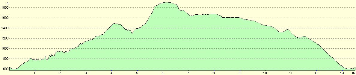
For more information on profiles, ascents and descents, see this page
Disclaimer
Please note that I take no responsibility for anything that may happen when following these directions. If you intend to follow this route, then please use the relevant maps and check the route out before you go out. As always when walking, use common sense and you should be fine.
If you find any information on any of these routes that is inaccurate, or you wish to add anything, then please email me.
All images on this site are © of the author. Any reproduction, retransmissions, or republication of all or part of any document found on this site is expressly prohibited, unless the author has explicitly granted its prior written consent to so reproduce, retransmit, or republish the material. All other rights reserved.
Although this site includes links providing convenient direct access to other Internet sites, I do not endorse, approve, certify or make warranties or representations as to the accuracy of the information on these sites.
And finally, enjoy your walking!
Nearby walks
| # | Title | Walk length (miles) |
|---|---|---|
| 30 | Edale to Crowden | 16.5 |
| 31 | Crowden to Standedge | 11.7 |
| 32 | Standedge to Mankinholes | 14.2 |
|
|

|