Walk #220: Linton to Newmarket
 |
 |
|
General Data
| Date Walked | 06/09/2002 |
| County | Cambridgeshire, Suffolk |
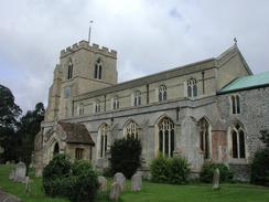
| Start Location | Linton Church |
| End Location | Newmarket bus station |
| Start time | 08.35 |
| End time | 14.26 |
| Distance | 17.3 miles |
| Description | This was a mixed walk, with a series of enjoyable green lanes being followed by long walks along roads which were nonetheless fairly enjoyable. The highlight of the walk was definitely the church at Balsham, whose architecture delighted me. |
| Pack | Today I carried my 30-litre Karrimor Hotrock rucksack, which contained a fleece, waterproof coat and trousers. It also contained the usual assortment of odds and ends including a book. It also had two litres of water in it, carried in a 2-litre Platypus container. |
| Condition | I am absolutely fine after this walk, with no major problems to report. This is a relief after the last walk, when I had trouble completing the full distance. I have no new blisters on any of my toes, and I could easily have walked further after a little rest. |
| Weather | The weather today started off overcast, with some occasional breaks in the cloud. As the day went on the breaks became more frequent and the cloud generally looked lighter. It was quite a windy day, and this made the cloud move fast and helped keep me cool. There was never the slightest threat of any rain, and Cambridge was basking in 24 degrees, so I would imagine that Newmarket was not too far away from this figure either. |
| OS map | Landranger number 154 (Cambridge & Newmarket, Saffron Walden) |
 |
 |
|
 |
 |
|
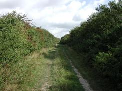
Map of the walk
Maps courtesy of Google Maps. Route for indicative purposes only, and may have been plotted after the walk. Please let me have comments on what you think of this new format. For a detailed table of timings for this walk, please see the table file.
Notes
I was slightly concerned about doing this walk, as I had found the previous one two days before to be very difficult. I was feeling much better, however, and so I decided to risk doing this local walk that could be shortened if necessary. I am very glad I did this, as I had no problems and found this to be a highly enjoyable walk.
I caught an early bus from Cambridge to Linton, and since I was early I decided to get a bite to eat at the North's Bakery in the village. To get to the start point I had to walk from the main road to the south of the village to the church, and I took my time doing this as I wanted a nice, relaxing walk after the strains of the one I did two days ago. Linton Church was very nice, and I spent a few minutes looking around it before setting off on the walk proper.
The first stop I made was at Balsham Church, which was open as it was being made ready for a wedding tomorrow. The interior of the church was very nice, and was dominated by the very imposing wooden font cover, which is the largest example of one of these that I have ever seen. I thought that it was probably very old, and was surprised to find that it had been carved in the 1930's by John Burrell, the rector of the church from 1910 to 1935. The counterweight for the lifting mechanism of the church is a First World War howitzer shell!
According to the chronicle of Henry of Huntingdon, written in about 1135, Balsham was the scene of a massacre by the Danes in 1010. All the residents were said to have been slain except for a man who defended himself within the tower of the church. The present church tower dates from the thirteenth century, and the rest of the church was rebuilt in the fourteenth.
I spent a short while resting in the shelter at Dullingham Station, sitting and planning the route onwards into Newmarket. This rest was not strictly necessary, but I had no time constraints and I felt it was wise to take things easy.
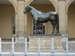
Just off The Avenue in Newmarket is Tattersalls auctioneers, which is the largest equine auctioneer in Britain. Horses have been bought and sold without interruption since 1870. The public are freely admitted to all sales, which take place between April and December.
The main aim of this walk was to connect together some disparate walks that I have done in this area before; in particular the walk from Great Chesterford to Cambridge via Linton, from Waterbeach to Dullingham, Waterbeach to Newmarket Railway Station and Prickwillow to Newmarket Bus Station. By visiting all of these points they are all now connected and the map looks saner.
Directions
This walk starts off at St Mary's Church, in the village of Linton between Cambridge and Haverhill. Turn right out of the churchyard and headup Church Lane. When Church Lane turns to the right after a few yards continue straight on up a path with a brick wall to the left and a white house to the right. When this path emerges at the B1052 road High Street. When the High Street is met cross it and continue in uphill along Coles Lane.
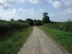
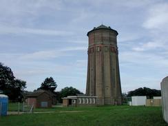
When Coles Lane ends at a T-junction with another road turn right and follow the road as it skirts to the right of a cemetery. When the cemetery ends turn left up a bridleway that heads uphill. Initially this bridleway is a tarmac path that skirts the eastern edge of the cemetery and then some houses, but as it gets higher and leaves the houses behind it becomes a stony and then a muddy track. Continue on up the bridleway until it emerges onto a gravel track beside the water tower at the top of Rivey Hill, from where there are some expansive views.
At the top of the hill continue straight on, passing to the right of the water tower, and descend down the track until it meets a bend in the B1052 road at the bottom of the hill. Continue straight on uphill along the B1052, passing the entrance to Chilford Hall Vineyard, until you reach a junction with the Icknield Way path on the right, which follows the course of an old Roman Road.
Turn right and follow the old Roman Road as it heads north-south-eastwards for about a kilometre until another path leads in from the left just before the hedge on the left ends and the Roman Road emerges into a more open area. Turn left up this path between two hedges and follow it as it heads northwards, curving past Wood Hall before ending at the B1052 road in Balsham.
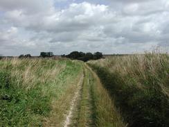
At the B1052 turn left past the post office and stores and follow the road as it swings around to the left. At the bend a road heads straight on past the village green towards the church, which is well worth a visit. Continue on along the B1052 westwards until the road swings around to the left. At the bend turn right to head up Fox Road past a little turning triangle. The tarmac road soon ends and the path continues along a rough track, which again is part of the Icknield Way. The track climbs uphill with some power lines to the left, and then slowly starts to descend once again.
Near Grange Farm the track stops being grassy and becomes a stony, wide track as it reaches the bottom of the hill and passes over a dry stream. The path becomes grassed again as it heads uphill, with hedges on both sides. Near the top of the hill the track becomes rougher and is heavily rutted, until eventually a road is reached beside Green End Farm.
Cross the road and continue on down the other side down another green lane. Fairly soon the track curves to the left and then the right, and when the track meets another road continue straight on down a stony track. At the bottom of the hill this crosses another dry stream and then turns to the right to pass a small building and ends at a tarmac road.
Turn left and follow the road uphill, still following the course of the Icknield Way. When the Icknield Way leaves the road to the right at the top of the hill continue straight on along the road. Pass over two sets of crossroads and continue on to the left of Underwood Hall. Here the road curves slightly to a more north-easterly bearing until the road ends at a T-junction with Station Road just outside Dullingham.
If you wish to visit Dullingham Station or wish to cut the journey short by going back to Cambridge, then turn to the left and follow Station Road downhill for a little under half a mile to the station. If you do not want to visit the station then turn right along the road and then after about twenty or thirty yards take the first road to the left, which is called Eagle Lane.
The lane immediately passes an attractive thatched cottage and a gateway guarded by columns topped with Eagles that leads into the grounds of Dullingham House. When the houses end on the left the road is flanked by trees on both sides, making this stretch of road most pleasant. When the road ends at a T-junction with the B1061 road beside a very ornate set of gates continue across the B1061 up another road. This road heads north-eastwards for about a kilometre until it ends at a T-junction by Stetchworth Park.
At the junction continue straight on along a road that skirts the western end of the park. The road immediately curves to the right to head in a north-easterly direction. It climbs uphill and then descends to cross over the course of the Devil's Dyke, which I have walked many times before. The road continues on downhill past Court Barns Farm where it swings slightly to the right to head in an easterly direction to end at a T-junction with another road, called Woodditton Road.
Turn left along this road as it dips slightly before climbing uphill in a north-north-westerly direction. At the top of the hill it curves to the left to head in a more north-westerly direction as it passes the entrance to the Hadrian Stud. It then descends in the same direction down towards Newmarket, with some expansive view available ahead over the town.
A short distance after houses start on the right the road passes over a railway line by means of a bridge. Immediately on the other, northern, side of the bridge turn right down Paddocks Drive. This skirts the northern side of the railway line until it swings to the left and then the right past the old station buildings, which are now a Sotheby's branch. The new station is a short distance further on to the right.
Past the station the road becomes Green Road until it ends at a T-junction with The Avenue. Turn left down The Avenue and follow it north-westwards until it ends at the A1304 Market Street in the centre of the town opposite the King Edward VII Memorial Hall. Turn right down Market Street and follow it north-eastwards until you reach the clock tower. Here turn left and follow Fred Archer Way until you reach the Rookery Shopping Centre, outside which is the bus station.
Distances
| From | To | Distance (m) | Ascent (ft) | Descent (ft) |
|---|---|---|---|---|
| Linton | Balsham | 4.0 | 400 | 167 |
| Balsham | Dullingham Station | 6.6 | 285 | 397 |
| Dullingham Station | Newmarket | 5.8 | 276 | 436 |
This makes a total distance of 16.4 miles, with 961 feet of ascent and 1000 feet of descent.
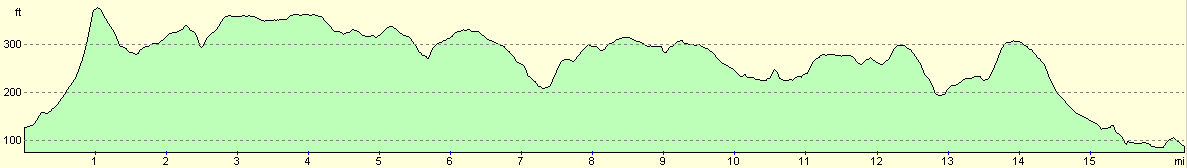
For more information on profiles, ascents and descents, see this page
Transport
There are regular bus services from Cambridge to Linton, on the 113 route that goes to Haverhill. A single ticket for this service cost £2.25. There are also regular busses on the X11 route from Newmarket back to Cambridge, and a single ticket cost £2.75. There are also train services from both Dullingham and Newmarket railway stations back to Cambridge.
Disclaimer
Please note that I take no responsibility for anything that may happen when following these directions. If you intend to follow this route, then please use the relevant maps and check the route out before you go out. As always when walking, use common sense and you should be fine.
If you find any information on any of these routes that is inaccurate, or you wish to add anything, then please email me.
All images on this site are © of the author. Any reproduction, retransmissions, or republication of all or part of any document found on this site is expressly prohibited, unless the author has explicitly granted its prior written consent to so reproduce, retransmit, or republish the material. All other rights reserved.
Although this site includes links providing convenient direct access to other Internet sites, I do not endorse, approve, certify or make warranties or representations as to the accuracy of the information on these sites.
And finally, enjoy your walking!
Nearby walks
| # | Title | Walk length (miles) |
|---|---|---|
| 7 | Waterbeach - Burwell - Swaffham - Waterbeach | 17.1 |
| 8 | Waterbeach to Newmarket | 17.5 |
| 10 | Waterbeach to Great Chesterford via Cambridge | 21.0 |
|
|

|