Walk #148: Head of Loch Lednock to Killin
 |
 |
|
General Data
| Date Walked | 19/08/2001 |
| County | Tayside, Central Scotland |
| Start Location | Head of Loch Lednock |
| End Location | Killin YHA |
| Start time | 08.20 |
| End time | 13.10 |
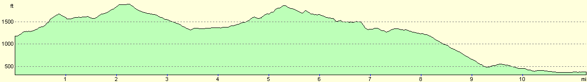
| Distance | 11.3 miles |
| Description | This was a boring walk up to the saddle between Ruadh Mheall and Meall Daimh and down past Loch Breaclaich into the picturesque village of Killin. |
| Pack | Today I carried full Pennine Way-specification kit. |
| Condition | As soon as I hit the track leading to the reservoir both feet started hurting. This got worse and worse as the walk progressed until near the end when I had to stop every five minutes to rest them. This was very demoralising and was probably caused by a combination of stony track and tarmac walking. Unfortunately there is more of this to come tomorrow, so I shall give my feet some TLC in the morning to try and prepare them. Apart from this problem with my feet I am more or less okay, with the biggest other problem being that my shins ache. |
| Weather | It started raining at 18.00 last night, and despite a respite when I woke up last night it rained through until the morning. When I woke up I considered leaving later, but there was no improvement forecast and the clouds still looked leaden, so I packed up and left. Within thirty minutes of leaving the rain became lighter and then eventually became a thin drizzle. This continued on and off all ay but improved later on whilst I was in the pub before some heavy rain came over in the evening. There was a light wind all day and the temperature was low for the time of the year. |
| OS map | Landranger number 51 (Loch Tay & Glen Dochart) |
 |
 |
|
Map of the walk
Maps courtesy of Google Maps. Route for indicative purposes only, and may have been plotted after the walk. Please let me have comments on what you think of this new format. For a detailed table of timings for this walk, please see the table file.
Notes
Today got off to an inauspicious start when I managed to pour coffee all over the inside of my tent. It turns out the netting on the sides of the inner tent are not ideal for holding a cup of coffee upright despite whatever I may have thought. After mopping up the resultant mess with a pair of woollen socks I had to pack up my inflatable bed mat as that was covered in coffee as well. After drinking the remaining half-cup of coffee and waiting for things to dry out slightly I packed up the rest of my gear. I had another look outside and unfortunately it was still raining, but I decided to set off anyway.
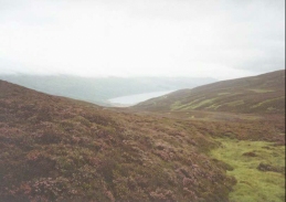
The weather was very disappointing today, with low cloud spoiling the lovely views that should have been available. When I left the campsite near Loch Lednock there was cloud just below me and cloud above - it was a fantastic sight to see, as if I was in the filling in a cloud sandwich.
When the top of the track from Loch Lednock was reached I had to navigate by compass over some rough ground - a task that I managed quite well. The track on the northern side of the pass was further away then I had judged and I was relieved when I reached the building that signified the start of the track that would lead towards Killin. Initially the track followed a large pipeline from Loch Breaclaich to Loch Lednock, the lowest part of which I had camped at the previous night. At this stage I was within a layer of cloud and the sight of the pipeline disappearing in the middle distance was quite strange.
There then followed a slow climb up to another pass on a rough track - a journey that I found boring with absolutely no views due to the weather. I eventually reached the large transmission mast that marks the highest point of today's walk, and then the long descent down to Loch Breaclaich began. When I reached the dam of the Loch I had a short rest before descending and rising along a surfaced track to another mast, and then descending through a forestry plantation to the valley floor.
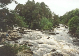
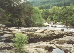
My feet were hurting so much that I stopped at the first pub the I reached when I got to Killin, which was situated by the fantastic Falls of Dochart. I had a couple of pints in the pub and phoned up to book myself into the Scottish Youth Hostel in Killin. When I left the pub I decided to walk to the YHA to drop off my pack, and on the way I came across a shop selling outdoor gear, and I managed to purchase a 1.8-litre Platypus Hoser and a pair of gloves, thus giving me two pieces of gear that I have been missing. At another shop I bought four apples and some chocolate bars, which means that I should have plenty of food for the next few days. When I eventually got to the YHA I dropped my bag off and went to a pub just down the road for another pint and a meal before going back to the YHA to read a newspaper. When the YHA opened I booked myself in and had a shower before heading out for yet more drink.
I feel very low as I write this, and I can scarcely be bothered to continue with this trip. I think that this is probably due to a combination of the state of my feet and the bad weather today causing what should have been a lovely walk to became a dreary trudge. I shall continue on tomorrow and see how I feel - unfortunately the route tomorrow involves yet more tarmac walking. I am very depressed about the way that things are going, and I cannot remember ever feeling this low on any previous walk, including the Pennine Way where I had other health problems.
Directions
This walk starts at the building beside the pipeline to the southwest of the western end of Loch Lednock Reservoir, at NN 6953 3024. Join the track beside the building and follow it to the west. The track is fairly rough and was muddy in places, but was far better than attempting to go cross-country. The track crosses a stream by a ford and then passes over Allt an Driuchd before it ends at a turning circle for land rovers.
The route now passes northwestwards over the pass between the summits of Meall Daimh to the southwest and Ruadh Mheall to the northeast. At first I attempted to follow a stream which flows slightly to the west of the ideal route as there were no obvious tracks on the ground, but this became impracticable at a little waterfall so I cut back to the east slightly. I then followed sheep tracks over the rough heather moorland until I came to the fence that marks the border between the counties of Tayside and Central Scotland.
From the fence head downhill off the pass in a northeasterly direction. When a stream starts to form off the boggy ground follow the eastern side of it as it descends. After about a mile from the fence a little building is reached, and this marks the beginning of the track that leads down to Killin.
The track heads downhill to a bridge that crosses the Allt Meall nan Damh. It then climbs uphill on the right hand side of a large pipeline, which is part of the pipeline where we started the day. The track continues beside the pipeline for about a kilometre until it makes a sharp turn to the left, to head westwards. After a short distance the pipeline ends at another building and goes underground, and the track then starts to rise past Ceann Creagach to a summit at a large transmitter mast at NN 637 320. It then starts to descend to the side of Lochan Breaclaich, and eventually the dam of the Lochan.
From the dam the track becomes surfaced and leads downhill for a short distance to cross a stream by a bridge before ascending again to skirt an area of forested land. A couple of kilometres after the dam a junction in the tracks is reached, with one branch heading uphill towards another transmission mast, and another going through a gate into the forest. Take the latter track as it descends fairly steeply downhill to meet the Killin to Ardenaig road. Turn left along this road and cross over a large stream by a pretty bridge.
Continue along this road for a little over a kilometre to a sharp left-hand bend. Almost immediately the road turns to the right to meet the A827 road. Turn right down the A827 past a pub and then cross the River Dochart by a bridge. The bridge is very narrow so it needs to be crossed carefully to avoid being hit by traffic. Across the bridge the road turns to the right to head north-northeastwards through Killin. About a kilometre and a half past the bridge is the Killin YHA.
This walk is based on one that can be found in the book 'The Famous Highland Drove Walk', by Irvine Butterfield, ISBN 0 9515996 5 8, and published by Grey Stone Books. It is described on pages 97 to 99 of this book.
Distances
| From | To | Distance (m) | Ascent (ft) | Descent (ft) |
|---|---|---|---|---|
| Head of Loch Lednock | Loch Breaclaich | 6.8 | 1667 | 1358 |
| Loch Breaclaich | Killin | 4.5 | 233 | 1352 |
This makes a total distance of 11.3 miles, with 1900 feet of ascent and 2710 feet of descent.
For more information on profiles, ascents and descents, see this page
Accommodation
I stayed at the Scottish Youth Hostel in Killin, situated on the A85(T) at the north end of the village of Killin.
Disclaimer
Please note that I take no responsibility for anything that may happen when following these directions. If you intend to follow this route, then please use the relevant maps and check the route out before you go out. As always when walking, use common sense and you should be fine.
If you find any information on any of these routes that is inaccurate, or you wish to add anything, then please email me.
All images on this site are © of the author. Any reproduction, retransmissions, or republication of all or part of any document found on this site is expressly prohibited, unless the author has explicitly granted its prior written consent to so reproduce, retransmit, or republish the material. All other rights reserved.
Although this site includes links providing convenient direct access to other Internet sites, I do not endorse, approve, certify or make warranties or representations as to the accuracy of the information on these sites.
And finally, enjoy your walking!
This walk was mentioned in the following routes:
| My sectional Land's End to John O'Groats walk |
Nearby walks
| # | Title | Walk length (miles) |
|---|---|---|
| 147 | Crieff to the Head of Loch Lednock | 15.4 |
|
|

|