Walk #149: Killin to Gleann Meran
 |
 |
|
General Data
| Date Walked | 20/08/2001 |
| County | Central Scotland, Tayside, Strathclyde |
| Start Location | Killin YHA |
| End Location | Gleann Meran |
| Start time | 08.45 |
| End time | 17.10 |
| Distance | 18.1 miles |
| Description | This was a long but satisfying walk, all except for the last couple of miles along tracks or roads. |
| Pack | Today I carried full Pennine Way-specification kit. |
| Condition | Surprisingly I am feeling relatively fine considering how bad I felt at the end of yesterday's shorter walk. My feet were aching terribly for the first seven miles of the walk as far as Kenknock, but the pain slowly subsided as the walk proceeded. For the first mile or so my shins hurt, but this subsided to nothing later on. I have a little abrasion on the top of the big toe on my left foot that will need a plaster on it, but apart from this everything is okay. My shoulders are a bit red, but nothing that I am concerned about. |
| Weather | The weather today started off as a mixture of both sunshine and showers, and consequently I got both too cold and too warm at different times of the day. There was even a hailstorm to contend with at an early stage of the walk. The weather slowly improved as the day progressed and the last shower occurred whilst I was descending down towards Loch Lyon. At times the wind was quite strong, particularly in exposed locations. |
| OS map | Landranger number 50 (Glen Orchy & Loch Etive) and Landranger number 51 (Loch Tay & Glen Dochart) |
 |
 |
|
Map of the walk
Maps courtesy of Google Maps. Route for indicative purposes only, and may have been plotted after the walk. Please let me have comments on what you think of this new format. For a detailed table of timings for this walk, please see the table file.
Notes
Brilliant! What else can I say? Yesterday was a bit of a disaster, with painful feet and inclement weather, so I was not looking forward to today's walk and it was with some trepidation that I set out. If you had told me that I would get within four kilometres of Gorton then I would not have believed you - I have essentially gained a day on my schedule, and I reckon that I have about two miles to walk to Gorton (all downhill), and then five miles on to Achellader, and then four miles on to Bridge of Orchy - a total of about eleven miles!
If I aim to get to Gorton by ten tomorrow morning then I could be in either the Bridge of Orchy or Inveroran hotel by 14.00 - if they will have me as I am not currently booked in.
So how far have I walked today? I reckon that it is seven miles from Killin to Kenknock (this was shown by a milestone near Killin), three miles from Kenknock to the Loch Lyon dam, five and a half miles from the dam to Gleann Meran, and finally two and a half miles from Gleann Meran to my campsite. This makes a rough total for the day of about eighteen miles, which is far more than I had expected to have done, and is superb considering how rough I felt when I set off. This improvement could partly be to do with the fact that I purposefully walked at a slow rate on the initial section to Kenknock in order to ease the pain in my feet.
As soon as I get down into the valley at Gorton in the morning I will see if I can get a signal on my mobile phone so that I can phone up the hotel at Bridge of Orchy - I hope that I manage to get in there as the hotel at Inveroran is another couple of miles further on.
I met a couple of nice people today - one being a lady weeding her garden in Glen Lochay, the other a JCB driver on the track alongside Loch Lyon. I had a five-minute chat with the latter, who turned out to be a thoroughly nice gent who gave me advice on where (and where not) to camp.
The terrain between the end of the track in Glean Meran to my campsite was quite tough going, particularly considering how tired my legs were. I made it up to the site by following sheep tracks, but unfortunately whilst crossing the Allt Meran for the second time one of my boots went straight in.
The plateau on this pass is very boggy - it took me a while to find an area of firm ground suitable for pitching my tent. I am not too pleased with the location as it is a little exposed, but I have aligned my tent in a south to north direction along the line of the pass, and the wind is blowing end-on to it. It is very bleak up here and for some reason I am getting very lonely - I am particularly longing to see my girlfriend, whom I am missing terribly. I cannot even gat a radio station up here, which adds to my sense of desolation. On the other hand I have had a very good day's walking which has cheered me up no end.
I had planned to spend the night at the Lochan in the pass above Kenknock, and when I was resting at Kenknock this still seemed like a good idea. However the climb up the hill to the pass went very well, and as it was still early I decided to press on. When I reached the Loch Lyon Dam near Pubil I still felt okay, so again I pressed on up the track that skirts the northern edge of the Loch. And when I reached the end of this track I thought "sod it!", and decided to press on a short distance in order to shorten tomorrow's walk.
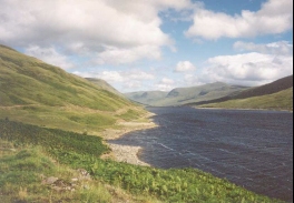
Loch Lyon looked absolutely stunning at times whilst I was walking alongside it - the wind was causing the surface of the water to have little waves, and when the sun was shining on it it gave a sort of dimpled mirror effect. The views of all the high hills surrounding the lake was also spectacular - I shall have to return and climb them sometime.
This is the first time in years that I have done some truly remote camping on my own, and before I do another trip like this I will have to find some form of mental activity - for example crosswords - to do whilst I am in the tent. This may help relieve the boredom that I feel and consequently make me more positive.
(Next morning): The wind last night was quite unbelievable, and at times I was concerned that the flysheet of my tent could be ripped off and fly away. Fortunately my tent stood up very well to the battering, but the sheer noise of the wind and rain led me to have a restless night's sleep. I got up at five in the morning to go to the toilet, and the sheer force of the wind nearly blew me over. I do not fancy having to walk across the bog down to Gorton in this weather.
Directions
Leave the YHA and turn left to head north up the A827 road. Shortly after a bridge over the River Lochay a road leads off to the left, just before the A827 turns road to the right. Take this road as it heads westwards along the northern side of the River. A little over two kilometres from the junction another junction is reached with a road coming in from the south, and beside this junction is a hydro-electric power station. Continue along the road past the power station, and pass the pipeline for the hydro-electric scheme as it heads down the hillside to the north.
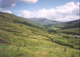
The road then continues in a rough westerly or south-northwesterly direction, passing Duncroisk and going over the Allt Dhuin Croisg by a bridge. Shortly after the farm at Tulich a cattle grid is passed and the road becomes unfenced for a little over a kilometre until just before Low Botaurnie is reached. Continue westwards along the road for a couple of kilometres from Low Botaurnie until the farm at Kenknock is reached.
Shortly after the farm at Kenknock a junction is reached, with a track heading south to a bridge over the River Lochay and another surfaced track heading north up the hillside to the right. Take the track to the right and follow it as it zigzags up the hillside to the eastern side of the Innisraineach Burn. This is a fairly steep climb, but the zigzags in the road ease the climb. About two-thirds of the way up the hill a track leads off to the left, crossing the burn. Do not take this track, but continue on the main one as it turns to the right up the hillside.
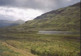
Eventually the gradient starts to ease and the track (which is still surfaced) goes along a pass between Creag nam Bodach to the west and Sgiath Bhidhe to the east. Near the top of the pass Lochan Learg nah Lunn is reached, which is the source of the Innisraineach Burn that has been followed from Kenknock. The track reaches a summit near the border between Stirling and Perth and Kinross, and then starts descending to the east of the Allt Lairig nan Lunn down the northern side of the pass. Fairly soon Loch Lyon dam becomes visible, and eventually the dam and Pubil, the little village created to house workers for the dam, are reached.
There are a network of roads at the bottom of the dam. Cross over a bridge over the River Lyon, and past a junction with a road to the left which heads to the base of the dam. Shortly after this another track leads off to the left. Take this track, which is the first section of unsurfaced road or track all day, as it climbs up to the north of the dam and Loch.
This track continues along the northern side of the Loch for over six kilometres, with all of them having a lovely view of Loch Lyon below. The track is unsurfaced but nonetheless is fairly good going and relatively flat, which allows good time to be made. The 1:50,000 OS map shows the track ending at a building at about NN 409 420; however the track actually continues on past here. Follow the track as it goes along the north-eastern side of the northern limb of the loch and enters Gleann Meran. The track becomes rougher near the end of the Loch, until eventually it crosses the Allt Meran and turns to follow the northern bank of the Allt Cailliche westwards.
Unfortunately the track has to be left here, so follow the eastern bank of the Allt Meran as it heads northwards. There are a few rough sheep tracks on the ground, but unfortunately these cross the Allt Meran two or three times, so it may be best to try and keep to the eastern bank of the stream. The stream curves around to the east side of Sidh Trom'aidh before eventually coming out on the southern end of the pass between Beinn a' Chreachain to the west and Meall na Feith' Fade to the east.
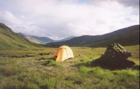
This pass is very flat and is also fairly boggy, so it is best to try and keep to the east edge of it where the ground is slightly higher and therefore dryer. Groughs are visible with lots of bleached white bog oak roots which make handy bridges over the boggy areas. About three-quarters of a kilometre from the start of the pass an old fence line is reached, which marked the border between Tayside and Strathclyde. There is a dry mound beside a rock which I found was suitable for placing my tent; there were not many alternatives around in the pass.
Distances
| From | To | Distance (m) | Ascent (ft) | Descent (ft) |
|---|---|---|---|---|
| Kilin | Kenknock | 7.3 | 909 | 541 |
| Kenknock | Loch Lyon Dam | 4.4 | 1076 | 797 |
| Loch Lyon Dam | NN 3922 4510 | 6.4 | 1319 | 922 |
This makes a total distance of 18.1 miles, with 3304 feet of ascent and 2260 feet of descent.
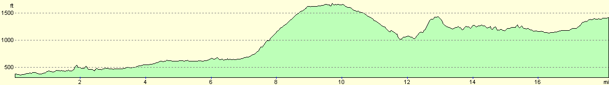
For more information on profiles, ascents and descents, see this page
Accommodation
I stayed in a tent at NN39224510 in the pass between Meall na Feith' Faide and Beinn a' Chreachain; there were not many places dry enough to camp at in this pass and this was one of the few patches of firm ground to be found.
Disclaimer
Please note that I take no responsibility for anything that may happen when following these directions. If you intend to follow this route, then please use the relevant maps and check the route out before you go out. As always when walking, use common sense and you should be fine.
If you find any information on any of these routes that is inaccurate, or you wish to add anything, then please email me.
All images on this site are © of the author. Any reproduction, retransmissions, or republication of all or part of any document found on this site is expressly prohibited, unless the author has explicitly granted its prior written consent to so reproduce, retransmit, or republish the material. All other rights reserved.
Although this site includes links providing convenient direct access to other Internet sites, I do not endorse, approve, certify or make warranties or representations as to the accuracy of the information on these sites.
And finally, enjoy your walking!
This walk was mentioned in the following routes:
| My sectional Land's End to John O'Groats walk |
Nearby walks
| # | Title | Walk length (miles) |
|---|---|---|
| 148 | Head of Loch Lednock to Killin | 11.3 |
| 150 | Gleann Meran to Bridge of Orchy Hotel | 11.1 |
|
|

|