Walk #150: Gleann Meran to Bridge of Orchy Hotel
 |
 |
|
General Data
| Date Walked | 21/08/2001 |
| County | Strathclyde |
| Start Location | Gleann Meran |
| End Location | Bridge of Orchy Hotel |
| Start time | 07.55 |
| End time | 13.00 |
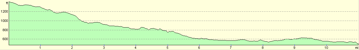
| Distance | 11.1 miles |
| Description | This was an initially boggy walk that becomes a walk along a rough track with a final section along the A82(T). |
| Pack | Today I carried full Pennine Way-specification kit. |
| Condition | My condition has probably suffered due to not taking more breaks due to the atrocious weather. The biggest problem that I have is with my back, which was itching and hurting all day. This is an exact copy of the problem that I had during my Pennine Way walk, which is worrying as it made carrying my pack much harder. I will rub some cream into it overnight and see how it feels in the morning. Aside from this my feet are in about the same state as they were at the end of yesterday's walk, and my legs are fine. My shoulders are a bit red but nothing to really worry about. |
| Weather | Today's weather was pretty horrible. When I woke up this morning the wind was howling around the tent, and when associated with the sounds of the rain hitting the tent there was quite a noise. I decided to set off early and packing my tent up in the wind was difficult. As I descended down across the bog to Gorton the weather appeared to improve slightly, but unfortunately this was a false impression as when I started to walk along the track westwards from Gorton it started to rain again. Unfortunately due to the direction I was walking it was raining horizontally into my face, which was more than a little uncomfortable. The wind was also fierce at times which tended to totally negate the medium temperatures. The wind and rain continued all day, and walkers doing the West Highland Way came into the hotel bedraggled all day. |
| OS map | Outdoor Leisure number 38 (Ben Nevis & Glen Coe) or Landranger number 50 (Glen Orchy & Loch Etive) |
Map of the walk
Maps courtesy of Google Maps. Route for indicative purposes only, and may have been plotted after the walk. Please let me have comments on what you think of this new format. For a detailed table of timings for this walk, please see the table file.
Notes
This was a walk that was totally spoilt by the weather, which was frankly awful. The first couple of miles to Gorton was over some rough terrain, including some very boggy areas of ground. This made the going fairly tough, but fortunately it was not too bad. Eventually the electricity pylons that mark the location of the cattle creep that can be used to get under the railway became visible, and I used this and a bridge over the Water of Tulla to get myself to Gorton. Unfortunately I did not get there unscathed - near the beginning I ended up in a knee-deep bog which was a superb way of starting a walk - one boot full of water and filthy legs.
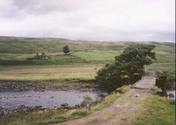
The track which led westwards from Gorton to Achallader was fairly rough, with some parts being stony and other parts sandy. It was still far better than the rough moorland that I had crossed earlier, however, and the biggest problem that I had was with the wind which was blowing the rain straight towards me. Despite this I made relatively good time as far as Barravourich, where an old abandoned farmstead was well set off against a very rickety bridge that carried the track across the Water of Tulla. I fond it hard to see how any vehicle could make it over this bridge, yet alone a land rover and trailer that passed me shortly afterwards.
At Achallader I phone up the Bridge of Orchy hotel to book myself a room for the night - I really did not fancy camping out again after the previous night. The room was going to be quite expensive - forty-nine pounds, but I decided that it was worth it to be able to have a bath and a relaxing time.
The walk along the main road was highly unenjoyable and not a little dangerous, particularly considering the wet conditions. Having lorries and buses go roaring past you can be a little frightening, but I did not fancy doing the alternative (undefined) route in the driving rain. Walking along busy main roads such as the A82 is far too dangerous to be done frequently, and I would advise anyone trying to do this walk to either do the alternative route defined in The Famous Highland Drove Walk book, or cut across through the estate road along the northern side of Loch Tulla to the Inveroran Hotel.
The route down to the railway at Gorton was helped by a very rough track - which was sometimes nothing more than tyre tracks over mud and bog - which helped me to avoid the very worst areas. I wondered what sort of vehicle could cope with this terrain, and later on I saw a land rover pulling a trailer, on which was a six-wheeled buggy that was obviously used over such terrain. Boggy areas are a pain to walk through, but to some extent this is made up for by the lovely colours that can be seen - the greens and purples of the heather, the white of the bog-oak, the blacks and browns of the peat and the greens of the little grass that can be seen.
The Bridge of Orchy Hotel was very busy with walkers coming in from the West Highland Way. When I arrived there were a couple of Dutch ladies sitting in the two chairs in the reception, so I had to stand until someone came to the counter. I was told that my room would not be ready until about 15.00, so I dumped my pack off in the cloakroom and went into the bar for a drink or three. The Hotel has a very nice-looking bunkhouse with a drying room attached that I would probably have chosen to use if I had known that it existed, and most of the people doing the West Highland Way chose to stay there.
The couple of Dutch ladies who were in the hotel's reception when I arrived had got so fed up with the rain during the day that they had hitch-hiked to the hotel; whilst I was waiting for my room to be ready a stream of drenched people slowly came through the doors to the hotel until eventually the cloakroom was stuffed full of rucksacks and coats.
The hills were unfortunately covered in cloud for all of today, which means that the only potentially good thing about today's walk was ruined. Tomorrow should be totally different with the traverse of the Black Mount. I can only hope that I can see some of the lovely views, such as that of Buchaille Etive Mor.
What I do after tomorrow depends on the weather - if it promises to be good that I will probably walk up to Spean Bridge, otherwise I shall walk along the West Highland Way to Kinlochleven and then Fort William - which should be a much easier route in bad weather.
Directions
Leave the campsite at NN 3922 4510 and head north across the boggy land. Eventually a stream, the Allt Learg Mheuran, is reached. As soon as possible cross over to the western (left-hand) side of the stream and start the long descent down the Learg Mheuran. The going is fairly tough, with some boggy areas to be climbed over. Eventually the Glasgow to Fort William railway line can be seen, and immediately in front of it can be seen a power line. Head towards a place where there is a kink in the line of the power cables and two pylons are in line near Rowantree Cottage. The stream turns to the right to head northeastwards at NN 395 476, and before it does so start heading on a more westerly direction as the rate of descent starts to slow. The ground now becomes fairly boggy, but an extremely rough track starts leading in the correct direction. Pass under the power lines and reach the railway at NN 384478. Here a stream passes under the railway via a bridge; immediately to the right of this bridge is a cattle creep that can be used to get under the railway.
The rough, muddy track continues on in a north westerly direction as it descends from the railway before turning west to cross a stream by a ramshackle bridge. It then heads northwestwards to cross to the northern side of the Water of Tulla by a footbridge. Follow the track westwards as it becomes slightly firmer until the farmstead at Gorton is reached.
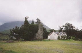
From Gorton the navigation becomes much firmer as a rough unsurfaced track leads southwestwards, skirting the northern bank of the Water of Tulla. After about four kilometres an old abandoned farmstead at Barravourich is reached. Here a track leads off to the left, crossing to the southern bank of the Water of Tulla by another ramshackle bridge. Use this track and then follow it as it skirts the southern edge of the river. After just under a kilometre the track crosses a small stream by a ford and shortly after this over a bigger stream, the Allt Ur, by another ford. I just managed to get over this last ford without getting my feet wet, but if the level of the stream had been any higher it would have been impossible. After this ford the little hamlet of Achallader is reached, where there is B&B accommodation available.
The track becomes firmer as it heads southwestwards from Achallader from a kilometre until it reaches the A82(T) road beside Loch Tulla. Turn left down the A82(T) and carefully follow it southwards for about three miles. This is a very unpleasant section of the walk, and if the weather is nice it may be better to find a route along the hillside to the east. Fortunately there are some long, straight sections of the road with only three bends which at least lets you see traffic coming towards you. Eventually the little village of Bridge of Orchy becomes visible, and the Bridge of Orchy Hotel is easy to find on the right-hand side just after a road junction.
Distances
| From | To | Distance (m) | Ascent (ft) | Descent (ft) |
|---|---|---|---|---|
| Gleann Meran | Gorton | 2.9 | 82 | 538 |
| Gorton | Achallader | 4.5 | 197 | 568 |
| Achallader | Bridge of Orchy | 3.7 | 177 | 269 |
This makes a total distance of 11.1 miles, with 456 feet of ascent and 1375 feet of descent.
For more information on profiles, ascents and descents, see this page
Accommodation
I stayed in the Bridge of Orchy Hotel. There is also a bunkhouse available with a drying room which is apparently well-appointed.
Disclaimer
Please note that I take no responsibility for anything that may happen when following these directions. If you intend to follow this route, then please use the relevant maps and check the route out before you go out. As always when walking, use common sense and you should be fine.
If you find any information on any of these routes that is inaccurate, or you wish to add anything, then please email me.
All images on this site are © of the author. Any reproduction, retransmissions, or republication of all or part of any document found on this site is expressly prohibited, unless the author has explicitly granted its prior written consent to so reproduce, retransmit, or republish the material. All other rights reserved.
Although this site includes links providing convenient direct access to other Internet sites, I do not endorse, approve, certify or make warranties or representations as to the accuracy of the information on these sites.
And finally, enjoy your walking!
This walk was mentioned in the following routes:
| My sectional Land's End to John O'Groats walk |
Nearby walks
| # | Title | Walk length (miles) |
|---|---|---|
| 149 | Killin to Gleann Meran | 18.1 |
| 151 | Bridge of Orchy to Kings House Hotel | 12.1 |
| 907 | West Highland Way: Inversnaid to Tyndrum | 19.1 |
|
|

|