Walk #272: Tollesbury to Maldon
 |
 |
|
General Data
| Date Walked | 20/11/2002 |
| County | Essex |
| Start Location | Tollesbury |
| End Location | Maldon |
| Start time | 08.32 |
| End time | 15.08 |
| Distance | 17.2 miles |
| Description | This was a long, and if the truth were to be told, fairly boring walk along sea banks westwards long the northern bank of the River Blackwater. |
| Pack | Today I carried my 30-litre Karrimor HotRock rucksack, which was filled with my packed lunch, waterproof leggings, water bottle and a couple of spare shirts, together with the usual assortment of odds and ends. |
| Condition | I feel absolutely fine after this walk, with no problems to report. Fortunately the aches in my left ankle which I had yesterday had disappeared, which is a great relief to me. |
| Weather | The weather forecast for today was for heavy rain, so I was expecting to get wet when I left the van. Fortunately this turned out not to be the case, and I only felt a couple of spots of rain all day despite a heavy layer of cloud overhead. There was very little wind, and the temperatures were not too bad so all in all it was not too bad a day. |
| OS map | Landranger number 168 (Colchester, Halstead & Maldon) |
 |
 |
|
 |
 |
|
Map of the walk
Maps courtesy of Google Maps. Route for indicative purposes only, and may have been plotted after the walk. Please let me have comments on what you think of this new format. For a detailed table of timings for this walk, please see the table file.
Notes
This walk involved the start of the walk down the penultimate large river estuary before I get to the Thames and London - the rivers Blackwater and Crouch having to be walked around on the way south. Unfortunately these estuaries promise to be fairly boring as they promise to be nothing but sea walls the entire way around.
When I left the van this morning I said goodbye to Mike as it was his last day driving Mervan as he has exams for his MSC tomorrow. He drove Mervan back to Cambridge where a friend, Terry, whom I used to work with, took it over. It turns out that Maldon was not the best place to meet the van, as we found it hard to find a place to meet as I was guiding myself using an OS map and Terry was using a road map. We eventually succeeded, and we then found a street that we could park down. The predominant factor for choosing a place to park the van seems to be the close vicinity of a pub; this allows us to use its toilets and have a drink or two before retiring, which is exactly what Terry and I did tonight. The pub was quite dark, and all the locals were chatting away in a way that only locals in a pub can, and I felt as if Terry and myself were outsiders on a soap set.
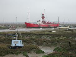
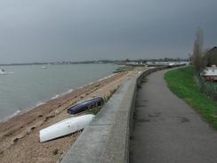
Early on in the walk I passed the remains of a pier in the Tollesbury Wick Marshes Nature Reserve. This pier was the terminus of the Tollesbury and Kelvedon Light Railway (otherwise known as the Crab and Winkle line), which opened in 1904 and closed to passengers in 1951. The idea of this line was to make the area another yachting and holiday resort such as Burnham-on-Crouch but this never materialised and it is now a very deserted area. The tide was high when I walked past and there was very little of the remains of the pier to be seen - the deck of the pier itself was removed in 1940 to prevent it from being used as a landing place by any German invasion force. After the 1953 floods the sea bans were raised, and it is very easy to see the large height difference between the embankment of the old railway line, which is at the height of the old banks, and the new height of the banks.
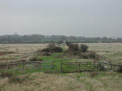
I am finding all this walking around sea and river banks to be quite boring. I am not passing through any of the local villages and all I see is either the estuary to my left or the fields to my right, which were hardly very varied. There is also very little information about the local area to read, which makes the situation worse. On such sections of the walk I find myself listening to Radio 4 or Radio 5 on my Walkman, putting my head down and just getting the walk done.
This evening Terry and I went to the local pub so that we could use the facilities and have a drink. This was then followed by a long chat until well after ten, which is far later than I have been going to sleep normally on this walk.
I stopped off at the first pub that I came to, which was the Mill Beach pub on Mill Beach. I had a pint of Mighty Oak Brewery IPA and, as I was quite hungry, for the first time on this trip I bought myself a pub lunch. After carefully studying the menu I decided on having a cheese and mushroom omelette, which was absolutely delicious and gave me fuel for the next few miles.
Whilst walking along the seawall near Heybridge Basin I came across a plaque on a bench. It read, "Our 'Do you remember?' spot. Thinking of a very special husband, daddy, son and dear friend to all who knew him. Robert 'Bob' Lay, 1960-2000. 'Forever in our hearts - His smile made the sun rise on all our lives, and it will never set in his memory.'". This was an absolutely superb inscription, and it bought a tear to my eye as I stood there transfixed for a few moments by the memorable and poignant words. I can only hope that when I die I am so well regarded as to have someone write such special words about me.
Tomorrow I have the start of the walk down the southern side of the River Blackwater to walk down, although I will probably only get as far as St Lawrence because the route is far more winding than yesterday's was. The next possible pick-up place after this, Bradwell, is another five miles on which would make it a more than twenty mile day, which I really do not feel like doing.
Directions
This walk starts off at the Woodrolfe Green car park and toilets, which is off Woodrolfe road in Tollesbury. Turn left out of the car park and follow Woodrolfe Road down towards the marina. In the marina turn right along a footpath that runs along the top of a sea bank which skirts the marina before entering the nature reserve. The bank continues on alongside Woodwolfe Creek before turning to the right to head southeastwards towards Shinglehead Poinnt.
At Shinglehead Point the bank turns to the right to head in a southwesterly direction past Blockhousse Bay to the remains of the old railway line and pier. Immediately after this the bank heads inland to skirt Mill Creek before heading out once more to Mill Point. The bank then heads in a westerly direction, twisting and turning as it does so, until it reaches a point the interior of a little bay near Gore Saltings. Continue on along the riverbank, passing Goldhanger and the start of the causeway which leads to Osea Island at Decoy Point before reaching the start of Mill Beach, where there is a concrete sea wall.
Continue northwestwards along this wall for about a mile until a little harbour is reached and the wall ends. Continue around the harbour and then walk south-southwestwards, passing over a bridge next to some lock gates before a point is reached. Here the path turns with the riverbank and heads in a more northwesterly direction for a little over amile. When the riverbank turns to the left to cross the head of a creek follow it and then turn right to walk along the left-hand bank of the now non-tidal creek. This path passes a bus depot before dipping down to join the surfaced road leading out from the depot.
Walk along this road to it's junction with a main road. Turn left down this road for a short distance until a roundabout with the B1018 is reached. At this roundabout continue straight on, crossing another roundabout and the River Chelmer before climbing uphill into the centre of Maldon. When the road ends at a T-junction with another rod, and with an old church on the left, turn left down the main shopping street and follow it eastwards through the town. After about half a kilometre turn left down a road that heads for a short distance to St Mary's Church, where this walk ends.
Distances
| From | To | Distance (m) | Ascent (ft) | Descent (ft) |
|---|---|---|---|---|
| Tollesburys | Goldhanger | 10.1 | 151 | 164 |
| Goldhanger | Maldon | 7.1 | 187 | 105 |
This makes a total distance of 17.2 miles, with 338 feet of ascent and 269 feet of descent.
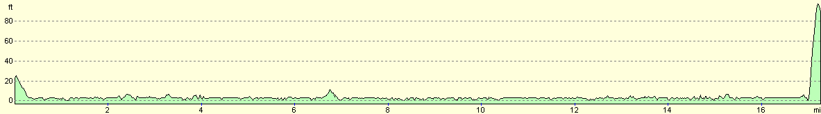
For more information on profiles, ascents and descents, see this page
Accommodation
we could not find any accommodation in the Maldon area, so we ended up parking on a street in Maldon, which had a pub and a shop at the end of it.
Disclaimer
Please note that I take no responsibility for anything that may happen when following these directions. If you intend to follow this route, then please use the relevant maps and check the route out before you go out. As always when walking, use common sense and you should be fine.
If you find any information on any of these routes that is inaccurate, or you wish to add anything, then please email me.
All images on this site are © of the author. Any reproduction, retransmissions, or republication of all or part of any document found on this site is expressly prohibited, unless the author has explicitly granted its prior written consent to so reproduce, retransmit, or republish the material. All other rights reserved.
Although this site includes links providing convenient direct access to other Internet sites, I do not endorse, approve, certify or make warranties or representations as to the accuracy of the information on these sites.
And finally, enjoy your walking!
This walk was mentioned in the following routes:
| My walk around the coastline of Britain |
Nearby walks
| # | Title | Walk length (miles) |
|---|---|---|
| 271 | Fingringhoe to Tollesbury | 16.7 |
| 273 | Maldon to St Lawrence | 16.0 |
| 274 | St Lawrence to Tillingham Marshes | 14.4 |
|
|

|