Walk #273: Maldon to St Lawrence
 |
 |
|
General Data
| Date Walked | 21/11/2002 |
| County | Essex |
| Start Location | Maldon |
| End Location | St Lawrence |
| Start time | 08.06 |
| End time | 14.50 |
| Distance | 16.0 miles |
| Description | This was a long and boring walk along the seawalls to the east of Maldon, which wind tortuously as they progress on towards St Lawrence. |
| Pack | Today I carried my 30-litre Karrimor HotRock rucksack, which was filled with my packed lunch, waterproof leggings, water bottle and a couple of spare shirts, together with the usual assortment of odds and ends. |
| Condition | I am fairly fatigued after this walk, but aside from this I feel fine. I had a couple of short periods of aching from my ankle, but this was nowhere near as much as I had a couple of days ago, which I am thankful about. One thing that I did differently that day was to have a pair of liner socks underneath my main socks; I have not dne this sine and so I have a feeling that this may have contributed to the trouble that I was having. |
| Weather | It was cloudy and overcast all day today, with no glimpses of the sun available during the period of the walk. There were several sharp showers, some of which were prolonged, but these did not occur in the last couple of hours so I ended the day dry. It was windier than it had been for the last couple of days, but not enough to inconvenience me greatly. It was not a very cold day and so I did not get chilled in the wind. |
| OS map | Landranger number 168 (Colchester, Halstead & Maldon) |
 |
 |
|
Map of the walk
Maps courtesy of Google Maps. Route for indicative purposes only, and may have been plotted after the walk. Please let me have comments on what you think of this new format. For a detailed table of timings for this walk, please see the table file.
Notes
At the quayside in Maldon I came across a group of Thames sailing barges - the first I had seen on this trip. These are quite frankly marvellous boats, and I love the way that the sails and the rigging are attached at multitudinous angles. Some of the barges are available for hire, and I can only wonder if they sail or use motors on such events (I would expect them to use engines, but I suppose that they may sail them). The barges looked beautiful against the quayside, and I spent a few minutes examining them in detail before I moved on.
The causeway across the water to Northey Island is quite impressive, and I ma glad that I caught it at low tide so that I could photograph it. The causeway was an integral part of the Battle of Maldon, which occurred between Viking invaders and the Saxons, who were led by Byrhtnoth, Ealderman of Essex, in 991. The Vikings, who alighted from their boats on the island and used the causeway to gain access to the mainland on the morning of the battle, defeated the Saxons. The battle itself occurred just inland from the causeway, near where South House Farm is nowadays.
I found the walk along he riverbanks to Maylandsea to be quite depressing as the path was exceedingly windy, with it curving around and around with little sign of it getting anywhere that I wanted it to. The area around Brick House Farm was the worst, with the farm being visible for several miles as the path wound its way around it. This was quite disheartening as I could also occasionally see Maylandsea yet it seemed that I was never getting closer to it.
I really did not want to spend another night sleeping in the van parked on streets, and so I was hoping that we could find a site for the night. This was particularly important because of the geography of the next few days, which meant that any site that we found could do us for two or three nights. Terry had called in at the tourist information office in Maldon and had been given a few numbers, but most of them were closed for the winter. When I got to the van I had resigned myself to a night sleeping away from a site for the night, but it turned out that there was one site, just to the west of Burnham on Crouch, which Terry had not been able to get through to. I tried this number, and thankfully the site was open and they had pitches available. This cheered me up no end, and so we drove across the peninsular to get to the site. Initially we had trouble finding the touring section of the site, but when we did find it was blocked by a police car and a van. With all sorts of thoughts going through my mind I went up to the people milling around to see if we could get through and surprisingly they told me that they were filming a murder mystery for the BBC at the house next door. Apparently it is going to be in the form of a competition, and there is a 50,000 pound prize for the person who guesses who did it. I did ask who had done it, but unsurprisingly they would not tell me ;-)
By the time that I got to Maylandsea I was absolutely desperate for the toilet. I walked along the seawall past the marina and could not find any facilities, so I joined the road and walked on back through the village, and still could not see anything. Eventually I stopped a lady who was walking her dogs and she told me that there was a bar at the marina and a pub further into the town, so I walked back to the bar which unfortunately was shut. I then walked through the village to the pub, which is away from the sea, and I was dismayed to find that this opened at seven in the evening! Eventually I realised that I would just have to hold on until I got back to the van, which I managed to do okay, but annoyingly I wasted fifteen minutes fruitlessly walking around the village.
Directions
This walk starts at St Mary's Church in Maldon. Head down the street for a short distance until it ends at a T-junction beside the quay. Join the quayside and turn right to walk around the seawall. It passes to the left of a large lake, which was drained because of an accident when I passed it, and heads eastwards.
When the wall nears a little rowing club turn right and head across a grassy area, following the right-hand fence of the club. When the fence ends join the track that leaves the club and follow it until the sea bank is reached once more. Turn left to join a footpath that runs along the top of the bank and follow it southeastwards as it passes the causeway leading to Northey Island. At Limbourne Creek the path diverts inland around the creek, but it is far easier and quicker to walk along the bank at the head of the creek.
The path continues along the bank past Southey Creek until it diverts inland past marshes and Cooper's Creek before heading out into the river once more to reach Mundon Stone Point. Here the bank turns to the right and winds its way beside Lawing Creek in a rough southerly direction before turning to head eastwards into Maylandsea.
In Maylandsea follow the path past houses before it passes the marina complex. On the other side of the complex it turns to head north along the eastern bank of Lawing Creek before turning inland once more down the western side of Mayland Creek. This heads inland for over a mile, and shortly after it passes a water treatment plant it skirts the very end of the creek. At the end of the creek the path turns to the left to head northwards along the eastern side of the creek until it reaches a caravan park.
Follow the path as it turns to the right, still following the bank, to head northeastwards and then eastwards to steeple Creek. When the bank turns sharply to the left to head northwards do not head straight on along another footpath (this looks like the right thing to do according to the map), but turn let and continue for about fifty yards along the top of the bank. When the bank is blocked by a fence turn right and head through three gates to a surfaced road. At the road turn left and follow it northwards until it ends at a marina next door to Stansgate Abbey Farm.
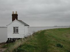
Walk through the gate into the marina and continue on up to the sea bank once more. Climb up onto the top of the bank and turn right to follow it eastwards. After a little more than a mile the path reaches the public house by the river at The Stone. At the pub turn right and follow the main road through the village southwards. The road passes a little shop on the right before reaching the car park of the St Lawrence Inn on the left, where this walk ends.
Distances
| From | To | Distance (m) | Ascent (ft) | Descent (ft) |
|---|---|---|---|---|
| Maldon | Maylandsea | 9.5 | 161 | 249 |
| Maylandsea | St Lawrence | 9.2 | 144 | 141 |
This makes a total distance of 18.7 miles, with 305 feet of ascent and 390 feet of descent.
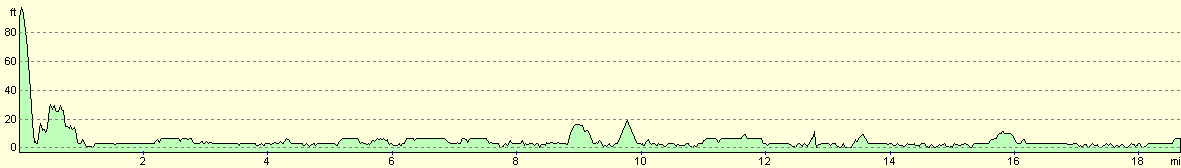
For more information on profiles, ascents and descents, see this page
Accommodation
We stayed at the Creeksea Place Caravan Park, Ferry Road, Burnham-on-Crouch, Essex CM0 8PJ. They can be contacted on (01621) 782387. This was a fairly nice site which was unfortunately fairy muddy after the rain of the last few weeks. The owner was very nice, and very kindly gave us a donation to our charity, and the site costs about twelve pounds per night with electricity hook-up. The site closes for three months at the end of November, and so we were quite lucky to get on the site, particularly when we could not find any other sites that were open in the area.
Disclaimer
Please note that I take no responsibility for anything that may happen when following these directions. If you intend to follow this route, then please use the relevant maps and check the route out before you go out. As always when walking, use common sense and you should be fine.
If you find any information on any of these routes that is inaccurate, or you wish to add anything, then please email me.
All images on this site are © of the author. Any reproduction, retransmissions, or republication of all or part of any document found on this site is expressly prohibited, unless the author has explicitly granted its prior written consent to so reproduce, retransmit, or republish the material. All other rights reserved.
Although this site includes links providing convenient direct access to other Internet sites, I do not endorse, approve, certify or make warranties or representations as to the accuracy of the information on these sites.
And finally, enjoy your walking!
This walk was mentioned in the following routes:
| My walk around the coastline of Britain |
Nearby walks
| # | Title | Walk length (miles) |
|---|---|---|
| 271 | Fingringhoe to Tollesbury | 16.7 |
| 272 | Tollesbury to Maldon | 17.2 |
| 274 | St Lawrence to Tillingham Marshes | 14.4 |
|
|

|