Walk #223: Seaton Sands to Auldhame
 |
 |
|
General Data
| Date Walked | 02/10/2002 |
| County | Lothian |
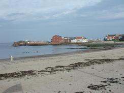
| Start Location | Seton Sands |
| End Location | Auldhame |
| Start time | 08.40 |
| End time | 16.21 |
| Distance | 18.6 miles |
| Description | This was a nice and enjoyable walk along the coast, taking in many little secluded beaches and rocky headlands. The views over the Firth of Forth were lovely, especially over to the islands in the Firth. |
| Pack | Today I carried my 30-litre Karrimor HotRock rucksack, which was filled with my packed lunch, waterproof coat, water bottle and a couple of spare shirts, together with the usual assortment of odds and ends. |
| Condition | I feel fine after this walk, and I could easily have walked further if I had needed to. I have got one blister today on one of the little toes on my right foot, and my back and legs are fine. Unfortunately my left ankle gave me more gip today, especially after I went over on it whilst walking over some cobble-sized rocks on a stretch of beach. Although this hurt for an hour or so, it soon stopped hurting so much and near the end of the walk it we giving me little bother. |
| Weather | The weather today was nice, with long periods of sunshine interspersed with cloudy periods. There was no sign of any rain, and I felt quite hot for some periods of the walk. All in all it was excellent weather for the time of year. |
| OS map | Landranger number 66 (Edinburgh, Penicuik & North Berwick) and Landranger number 67 (Duns, Dunbar & Eyemouth area) |
 |
 |
|
Map of the walk
Maps courtesy of Google Maps. Route for indicative purposes only, and may have been plotted after the walk. Please let me have comments on what you think of this new format. For a detailed table of timings for this walk, please see the table file.
 |
 |
|
Notes
This was a long but rewarding walk, with some nice coastal beaches and headlands passed on the way. As it was he second day of a long trip I was expecting it to be a hard walk, but unusually I found that it got easier as the day went on.
One section of beach near Longskelly was filled with rounded rocks of about cobble size, which made walking difficult. The section of beach covered by these rocks was not large, but there was no way of avoiding them and at about the middle of the stretch the inevitable happened and I went over on my bad ankle. This hurt for a few minutes and for an hour after I continued on, but by the end of the walk it felt no different than it had this morning, which is a good sign that it is recovering from the incident on Sunday.
At periods on today's walk I felt quite depressed as he enormity of the task that I had set myself became apparent. Yesterday the elation of actually starting (coupled with the champagne) made me feel good; today I just had the thought of a year of trudging around the coast. Fortunately this feeling passed before the end, and I started feeling quite good about the walk after I had passed the fifteen-mile mark.
It is nice to have got a fairly significant distance under my belt so early in the walk, and although I am still a few miles behind my schedule I have at least done more than my expected average of sixteen miles a day. Yesterday me feeling was one of elation at having started something which I have been planning for so long and seems so overwhelming in scope; today it seems more normal, as if it is what I am here to do.
This evening at the campsite we met a very nice couple and their young son from Edinburgh, who plied us with two bottles of wine. The lady is a civil engineer and used to work at the Institute of Civil Engineers in Great George (not King George as I incorrectly said) in London. This was a place I used to attend quite regularly when I was in London, and she is the first person I have met outside London who has ever been there. They were a very nice couple, and their friendliness was much appreciated.
At various times on today's walk I came across large concrete blocks in lines strewn across the tops of the beaches. These were very numerous, and I am not sure I they are some form of sea defence or tank traps, as the area had been used for practicing for D-Day during the Second World War. They had been there for some time, as many were half buried under various detritus or had trees growing off them.
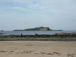
Towards the end of the walk Bass Rock looked superb in the afternoon light, gleaming white in the distance. The island is a famous bird sanctuary, and can be visited by boat from North Berwick. It was also to be a constant sight for the next couple of days, receding into the distance until I reached St Abbs. The same is true of North Berwick Law, a large and imposing volcanic stump just to the south of the town that remained visible in the distance for many miles.
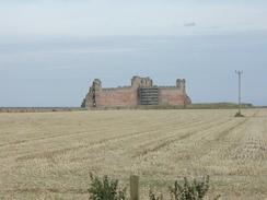
At the end of the walk near Auldhame the ruins of Tantaloon Castle became visible. These looked quite impressive from a distance, but I am unsure about how complete they are, as they do not seem very large or high from the angles that I could view them from. I have told Sam about them, so hopefully she may visit them tomorrow morning after she has dropped me off to start my walk.
Directions
This walk starts off at the bus stop in Seton Sands opposite Castle Terrace on the B1348. It follows the John Muir Way for most of the way, although the route I took diverged from that occasionally. There is a little promenade between the road and the sea that can be followed eastwards for a short distance until it ends. At the end of the promenade I went down onto the beach and I followed it around until I got near to the caravan park, where the John Muir Way leaves the beach and joins the road.
After a road comes in from the right on the outskirts of Longnriddy the pavement on the road ends, but fortunately a path leads off to the left through bushes to a tarmac drive that leads to a car park. From the car park, which is called Longriddy No. 1 car park, go to the beach an turn right to walk along an attractive beach with dunes to the right.
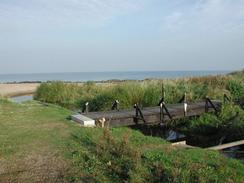
A little further on a creek runs into the sea and a little wooden bridge carries the path over the creek. Unfortunately it has been vandalised and he handrails have been smashed to pieces, although the structure of the bridge itself looks sturdy enough, The path passes over a grassed area over the rocks before emerging onto another beach. Here you can either descend over the rocks onto the beach, or you can follow the path as it skirts the side of the bay and meets a road.
Continue past the B1348 and A198 junction, and at this point join the beach once more. The path continues along a grassy area before meeting a car park at Ferny Ness. Enter the car park and follow the tarmac path around Ferny Ness. After a short distance leave the tarmac path and follow another path that winds around Ferny Ness near the sea before dumping you out unceremoniously on Gosford Sands.
You can either choose to walk along the path which runs between the A198 and the beach or straight across the beach. I chose the former, and when the road turns away to the right away from the beach continue along the path towards the Green Craigs Hotel. Follow the path past the hotel and past Craigelaw and Aberlady Points, between which a golf course has to be carefully negotiated. If it is low tide that you can avoid the golf course by walking along the beach instead of the path.
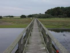
When the golf club house is reached join the tarmac drive from the club house and follow it down to meet the A198 road. At the junction turn left and follow it out of the village, with Aberlady Bay to the left. When the road turns to the right there is a little car park on the left. Turn into the car park, where there is a long wooden bridge that carries a path over a creek that runs into the bay. Cross this bridge and then continue on through a nature reserve along a good, firm path. Pass to the right of a little lake and then follow the path until you reach a little track that runs from right to left. Turn left down this path and follow it westwards to reach the beach at Gullane Sands.
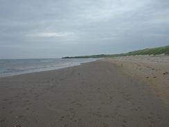
Turn right and follow the beach northwards until it ends near Gullane Point. At the end of the beach climb up onto the rocks at Gullane Point and then turn right along a track that climbs and falls past Hummell Rocks and onto the car park at Gullane Bents. At the car park descend down to the beach at Gullane Bay and then turn right to walk north-eastwards along the beach. When the beach becomes rocky as it approaches Black Rocks a path leads off to the right and closely follows the beach. The path then follows a little series of sandy and rocky beaches separated by little rocky promontories, many of he beaches looking nice and secluded.
Follow the path north-eastwards until it reaches a little headland by the little island of Eyebroughy. Here the path turns to the right slightly to follow the coast as it heads westwards. Follow the path past Longskelly Rocks and then descend down to the beach past the Brigs of Fidra towards Longskelly Point. Past Longskelly Point the beach becomes Broad Sands, which allow a good, fast progress eastwards towards Berwick. When Cowton Rocks are reached rejoin a path around the coast and follow it eastwards towards North Berwick. After a while I headed inland along a path that led across a golf course onto a road on the outskirts of North Berwick that I followed through the town to the lifeboat station
From the lifeboat station I turned right and followed a road that ran eastwards beside the sea. Just past a little car park the road climbed uphill to a viewpoint at Rugged Knowes, where some wonderful views over towards Bass Rock were available. I then walked around the very coastal edge of the golf course past the Leithens and Leckmoram Ness before climbing along the seaward side of some woodland up onto the A198 road.
At the A98 turn left and follow it eastwards to the farm at Castleton. Continue along the road as it runs to the right to head south past the car park for Tantallon Castle and climbs uphill before turning to the left beside farm buildings at Auldhame, where I finished this walk.
Distances
| From | To | Distance (m) | Ascent (ft) | Descent (ft) |
|---|---|---|---|---|
| Seton Sands | Gullane point | 8.0 | 210 | 184 |
| Gullane point | North Berwick | 7.3 | 394 | 423 |
| North Berwick | Auldhame | 3.3 | 476 | 338 |
This makes a total distance of 18.6 miles, with 1080 feet of ascent and 945 feet of descent.
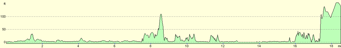
For more information on profiles, ascents and descents, see this page
Accommodation
We spent the night at the Tantallon caravan and camping par, which is just off the A198 road to the east of North Berwick. This site cost 12 pounds for two people with electrical hook-up, and was quite a nice little site. The shower block was quite unusual, with the cubicles containing both toilet and shower, which meant that you just went in and did all ablutions, which I think I actually prefer to the normal arrangement.
Disclaimer
Please note that I take no responsibility for anything that may happen when following these directions. If you intend to follow this route, then please use the relevant maps and check the route out before you go out. As always when walking, use common sense and you should be fine.
If you find any information on any of these routes that is inaccurate, or you wish to add anything, then please email me.
All images on this site are © of the author. Any reproduction, retransmissions, or republication of all or part of any document found on this site is expressly prohibited, unless the author has explicitly granted its prior written consent to so reproduce, retransmit, or republish the material. All other rights reserved.
Although this site includes links providing convenient direct access to other Internet sites, I do not endorse, approve, certify or make warranties or representations as to the accuracy of the information on these sites.
And finally, enjoy your walking!
This walk was mentioned in the following routes:
| My walk around the coastline of Britain |
Nearby walks
| # | Title | Walk length (miles) |
|---|---|---|
| 113 | Carfraemill to Tranent | 20.8 |
| 114 | Tranent to Edinburgh | 10.6 |
| 222 | Edinburgh Castle to Seton Sands | 14.0 |
|
|

|