Walk #224: Auldhame to Thorntonloch
 |
 |
|
General Data
| Date Walked | 03/10/2002 |
| County | Lothian |
| Start Location | Auldhame |
| End Location | Thorntonloch |
| Start time | 07.47 |
| End time | 17.19 |
| Distance | 20.6 miles |
| Description | This was a long walk around some beautiful beaches. It was slightly spoilt by a diversion that I had to make inland to cross the River Tyne where a perfectly good bridge was padlocked. |
| Pack | Today I carried my 30-litre Karrimor HotRock rucksack, which was filled with my packed lunch, waterproof coat, water bottle and a couple of spare shirts, together with the usual assortment of odds and ends. |
| Condition | I am very fatigued after this walk, which is understandable given the distance that I have walked. My feet were aching for he last few miles, but nothing that was not cured by taking my boots and socks off once I had finished and giving them a rub. My ankle did not give me much trouble and I generally feel fighting fit for tomorrows walk, especially after the recuperating effects of a shower. |
| Weather | The weather today was sunny with some cloudy periods but no threat of any rain. The wind was fairly strong, but for most of the time I was sheltered from it and therefore I got rather hot. It was a lovely walking day, although there was a little shower about 45 minutes after I finished the walk. |
| OS map | Landranger number 67 (Duns, Dunbar & Eyemouth area) |
 |
 |
|
 |
 |
|
Map of the walk
Maps courtesy of Google Maps. Route for indicative purposes only, and may have been plotted after the walk. Please let me have comments on what you think of this new format. For a detailed table of timings for this walk, please see the table file.
 |
 |
|
Notes
I woke up this morning with the stresses of the last couple of day's walking playing upon my body, with limbs that ached (although the alcohol that we drunk last night could not have helped!). I wanted an early start, and so shortly after sunrise Sam dropped me off at Auldhame Farm, a short distance to the east of the campsite where we spent the night, so that I could start today's walk.
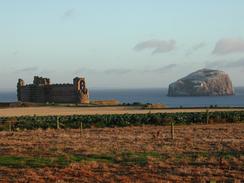
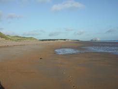
The walk along the A148, the coastal road, really did not appeal to me, and so I decided to cut across below Tantallon Castle so that I could gain access to the beach via a path that descended down the cliffs. The beach that I found was the first 'proper' piece of beach that I had seen on the walk; beautiful, clean sands, and the rock formations behind it also made it a rather special place. For the first time on the trip I felt like I was somewhere beautiful and secluded, and finding the beach was a magical experience.
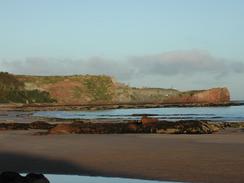
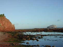
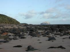
I headed down the beach until the sand ended and a rocky foreshore took over near the little lighthouse at St Baldred's Boat; this lead onto the Carr Rocks and Scoughall Rocks before I got back onto firm sands once more, and I followed these for a kilometre until the rocks began once more at the headland of St Baldred's Cradle. This headland marked the mouth of the River Tyne, which I would have to walk around. I followed a good path around from the Cradle to the tip of Sandy Hirst, a beautiful sandy promontory from which the southern bank of the estuary seems startlingly near.
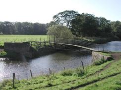
The other side of Sandy Hirst was extremely muddy as it passes Heckies Hole, and so I had to carefully make my way back to the shore, where I followed tracks through some woodland in the grounds of Tyninghame House. Eventually the mudflats ended and the River Tyne became much narrower, and the walk became much more enjoyable until I reached a footbridge marked on the Ordnance Survey map. In the book about his 1978 coastal walk, John Merrill describes clambering over this bridge, which has a gate in the middle, and so I was hoping that this would form a handy short-cut. I walked across the bridge, which was quite rickety and had some rotten boards, until I reached the gate in the middle. It was not easy to swing around the gate as there were spiked panels on either side of it, hanging over the river. I considered clambering around these as John Merrill had done, but the intervening years had taken their toll on the bridge and when I put my hands on one of the panels it rocked alarmingly, and I was sure that it would not be able to hold my weight.
Depressed, I headed back to the riverbank and started walking southwestwards along the north bank of the river. The bridge that carries the A198 over the river was only a kilometre away, but the woodland was thick and so instead of ploughing through it I followed a track that curved around and deposited me on the A198 a few hundred metres north of the river, and I then followed the A198 south over the bridge. I was thoroughly annoyed by not having been able to cross the footbridge, and so instead of following the southern bank of the river bank to the mouth, I walked on down the A198 for a few hundred metres before I reached a track that led off eastwards back to the estuary.. Here some flood banks that gave me some lovely views back towards Sandy Hirst, and I skirted the edge of this eastwards. After a while some woodland started, and when this curved away to the southeast I walked along its edge to reach the western side of Belhaven Bay.
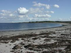
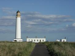
I was surprised to see a tidal bridge standing alone in the sand in the middle of the bay; as he tide was rising I could not access this and so I walked inland slightly to reach a footbridge over Biel Water, and I then followed some lovely paths along the southern and eastern edge of the bay, after which it climbed up onto some low cliffs beside a golf course. Eventually I reached Long Craigs, where Sam met me, and we walked on past the castle and on to the harbour in Dunbar. We stopped for a lunchtime drink in the Castle Hotel in Dunbar, which was a nice place to stop for a while. I was quite tired by this stage, but I was exceedingly keen to continue on, and so after half an hour I got up and started walking again. From Dunbar to the lighthouse at Barnes Ness there was a good path that skirted the edge of the cliffs past what seemed like a never-ending golf course. I passed Lawrie's Den and Mill Stone Neuk, before heading on past the beautiful White Sands to reach the elegant lighthouse at Barns Ness, which stood proud against the blue sky.
At the lighthouse the path ended, and I walked along the foreshore southeastwards towards Chapel Point. The walking was easy and enjoyable, and I soon found myself at the cross on Chapel Point, erected to commemorate scouts who died in the Second World War. A pleasant walk around Skateraw Harbour followed, which is dominated by the massive Torness Point lighthouse. The low cliffs around the lighthouse are protected by thousands of concrete crosses, interlocked for strength and to break up the waves that pound this stretch of coast. I found the number of these crosses to be surprising, and I found it amazing that each one had an individual number carved into it. At the jetty by the lighthouse I started to feel quite tired, and I really wanted the walk to end. I followed the edge of the cliffs around past the lighthouse, and then ended on towards the campsite where Sam was waiting for me.
As I approached the site I saw a group of women waiting at the boundary of the site, and as I neared them they started clapping, welcoming me to the site. Sam had told them about the walk, and they were there to congratulate me. I felt like a slight fraud as I had only walked sixty miles so far, but it was lovely to have such a nice welcome from people. By this stage I was so tired that after chatting to the ladies for a while I found it hard to get the energy to walk to the end of the park where Mervan was parked, and eventually I made it. I have found today to be by far the hardest day of the three days walking so far, and I can only hope that I have recovered properly by tomorrow.
Directions
This walk starts off beside the farm buildings at Auldhame, on the A198 road at grid reference NT 596 843. The road almost immediately curves to the right to head south; here continue straight on down a track that heads eastwards towards a little wooded area. Immediately after the wooded area starts turn left down a track that leads to the edge of he cliff, and then continue on down a path that leads onto the beach by the Gegan. As he tide was low I managed to walk eastwards to the Great Car and then down the foreshore to gain access to the northern end of the Peffer Sands; at high tides or in stormy weather you may not be able to do this. Walk south down Peffer Sands for a couple of kilometres until the little headland of St Baldred's Cradle is reached; climb up onto the headland and walk along a path that runs around the top of it. The path leaves the headland and continues on down to the southern end of the sand spit of Sandy Hirst.
At the end of Sandy Hirst walk around it and head back northwestwards up the other side of it, passing mudflats and Heckies Hole on the way. When the end of the spit is reached head inland slightly through some woodland until a track is reached; turn left and follow this track through the woodland and up past Tyninghame House. At the house take another track that heads southwestwards for a few hundred metres before cutting south across fields to a footbridge over the River Tyne. If you cannot cross the bridge then turn right and walk along the foreshore to a belt of woodland; enter this woodland and join a track that can be followed around for a short distance until it ends at the A98 road. Turn left and walk south along the A198 road to the bridge over the River Tyne, and then onwards until a track is reached on the left. Turn left down this track and follow it eastwards for about a mile until some flood banks by the estuary are reached.
Follow the bank eastwards along the southern edge of the estuary; near Hedderwick Hill a footbridge crosses a little stream, and on the other side of the footbridge a belt of trees begin. The path skirts between the foreshore and the trees, and when the trees curve around to the southeast follow their edge for a kilometre down to Belhaven Bay. Walk on along an obvious path to a footbridge over Biel Water, and on the other side turn left and follow a path around to reach the eastern edge of the bay. Follow the path northwards as it climbs up onto the low cliffs as it skirts between the cliff edge and a golf course; eventually the path reaches Long Craigs, where it becomes firmer and leads on to Dunbar Castle. Walk through Dunbar past the harbour to reach the foreshore at the eastern side of the town, where a path starts to head southeastwards beside the sea.
This path soon passes a golf course, which it skirts towards Lawrie's Den and Millstone Neuk to reach White Sands. Continue on along the edge of the sea towards the lighthouse at Barns Ness, and when this is reached the path ends, but continue on along the foreshore southeastwards for a couple of kilometres to Chapel Point. Walk around Skateraw Harbour, and follow a pat that leads eastwards towards Torness Power Station. A path heads around past the power station, passing a pier to reach Torness Point and Long Craig. Head south from here for a few hundred metres until a campsite is reached on the low cliffs to the right, where this walk ends.
Distances
| From | To | Distance (m) | Ascent (ft) | Descent (ft) |
|---|---|---|---|---|
| Auldhame | Tyninghame House | 6.8 | 92 | 187 |
| Tyninghame House | Dunbar | 7.1 | 344 | 381 |
| Dunbar | Thorntonloch | 6.7 | 292 | 299 |
This makes a total distance of 20.6 miles, with 728 feet of ascent and 867 feet of descent.
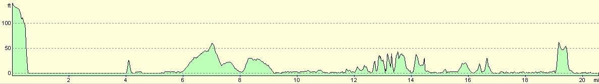
For more information on profiles, ascents and descents, see this page
Accommodation
We stayed at a campsite at Thorntonloch, just to the south of the Torness power station. This was a very nice little site, which comprises mainly static caravans and chalets, and has only a few spaces spare for people to visit. It is right by the beach and has some nice views out to sea.
Disclaimer
Please note that I take no responsibility for anything that may happen when following these directions. If you intend to follow this route, then please use the relevant maps and check the route out before you go out. As always when walking, use common sense and you should be fine.
If you find any information on any of these routes that is inaccurate, or you wish to add anything, then please email me.
All images on this site are © of the author. Any reproduction, retransmissions, or republication of all or part of any document found on this site is expressly prohibited, unless the author has explicitly granted its prior written consent to so reproduce, retransmit, or republish the material. All other rights reserved.
Although this site includes links providing convenient direct access to other Internet sites, I do not endorse, approve, certify or make warranties or representations as to the accuracy of the information on these sites.
And finally, enjoy your walking!
This walk was mentioned in the following routes:
| My walk around the coastline of Britain |
Nearby walks
| # | Title | Walk length (miles) |
|---|---|---|
| 223 | Seaton Sands to Auldhame | 18.6 |
|
|

|