Walk #225: Thorntonloch to St Abbs
 |
 |
|
General Data
| Date Walked | 04/10/2002 |
| County | Lothian, Borders |
| Start Location | Thorntonloch |
| End Location | St Abbs Harbour |
| Start time | 08.12 |
| End time | 15.18 |
| Distance | 15.4 miles |
| Description | This was a pleasant but energetic walk around the coastline eastwards from Thorntonloch. It had a mixture of road walking, path and track and trackless walking. The going was hard in places, but it was a highly enjoyable walk nonetheless. |
| Pack | Today I carried my 30-litre Karrimor HotRock rucksack, which was filled with my packed lunch, waterproof coat, water bottle and a couple of spare shirts, together with the usual assortment of odds and ends. |
| Condition | When I got up this morning I had trouble with the Achilles tendon on my left ankle, which hurt quite intensely. This pain continued on all day and was made worse when I tried to put a thick sock on. The only thing that alleviated it was tying the bootlaces on the left boot loosely, which appeared to alleviate the symptoms. Aside from this I was okay in all other ways, and have no other problems to report. |
| Weather | The weather today started sunny, with a fair amount of cloud around. The cloud slowly built up as the day went on and about halfway through the walk there was a slight drizzle shower. Later on during the climb up to St Abbs Head it started to rain heavily enough for me to put my coat on for the first time on this trip. There was a fairly powerful wind at times that meant that I got slightly cold, particularly at the top of St Abbs Head where I sought to take shelter behind the information cairn. |
| OS map | Landranger number 67 (Duns, Dunbar & Eyemouth area) |
 |
 |
|
 |
 |
|
Map of the walk
Maps courtesy of Google Maps. Route for indicative purposes only, and may have been plotted after the walk. Please let me have comments on what you think of this new format. For a detailed table of timings for this walk, please see the table file.
 |
Notes
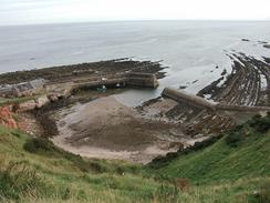
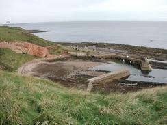
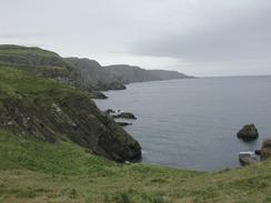
I awoke this morning with my legs feeling fairly stiff and my Achilles hurting, but I was still okay for a walk and I was looking forward to the challenge of the day ahead. I came across the first challenge fairly soon - about a kilometre south of the campsite the beach ended, and as I did not fancy walking along the rocky foreshore I decided to head up the cliff. This was easier said than done, but I soon found a gully that gave me a reasonable scrambling route up to the top of the cliffs. The A1 runs near the top of the cliffs for a few miles, and whilst I tried to avoid it by walking across fields by the edge of the cliffs eventually a gully forced me inland, and I was forced to follow the road for a little over a kilometre. Although I had been dreading this (the A1 is a notoriously busy and narrow road), I found that it was not too bad, and the verges were wide enough for me to walk on with few problems. Eventually I reached a road that led down to the beautiful little village of Cove, where I could see down right onto the harbour. I was very tempted to go down the steep track that leads down to the harbour, but in the end I decided it would be best to press on. From the top of the cliffs I could just make out the smugglers tunnel that runs through the cliffs - a truly dramatic location, and one that I would like to visit again.
At Cove I joined the Southern Upland Way, a National Trail, for about a mile until it headed inland near Pease Bay. At Pease Bay there is a caravan site with the caravans stacked at dizzy angles down the steep hillside - the road leading to the park is steep and windy, and it made me wonder how they got the caravans to their final positions - a crane must be involved somewhere in the process. Form here to St Abbs Head I was faced with my first real navigational decision of the trip - there is no path eastwards along the top of the precipitous cliffs, and the nearest roads are some miles inland. In the end I chose to compromise, and I followed some roads and tracks slightly inland from the tops of the cliffs. The going was quite hard, and this caused my Achilles to ache considerably in places, particularly when I had to force my way through thick undergrowth or climb out of deep and steep-sided gullies. I had the option of diverting a short distance to the top of the cliffs to visit the ruins of Fast Castle, immortalised by Sir Walter Scott as the Wolf's Crag in the bridge of Lammermoor. This castle was built in the early sixteenth century, and although I had been told that it was well worth visiting I decide against it as my legs and Achilles were aching.
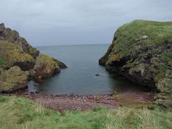
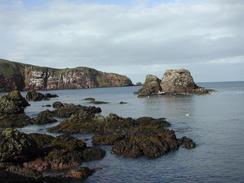
Just to the west of St Abbs Head I came across an unusual feature that I had seen marked on the map when I had been planning the trip. This feature was a dashed line a mile long, marked as a 'measured mile', crossing directly over several gullies. I enquired on the newsgroup uk.rec.walking, abut what this as, and I got told that it is a series of markers used to test the speed of ships at sea. This had intrigued me, and so I was determined to make the markers part of the walk. This was easier said than done, as they are on some fairly remote and rough terrain, and between them there are several deep gullies. I reached the first pair of markers easily (each end of the mile has a couple of markers - I assume that when they are lined up the ship knows that it is passing one), but I found the terrain towards the next one to be too hard going, and I floundered around whilst trying to find a better route. Eventually I reached the northern side of Coldingham Loch, and from here the going was easier as I descended downhill to the little bay at Pettick Wick, with some spectacular eroded cliffs beside it. By this time my legs were starting to ache, and my Achilles was much worse. I was glad when I joined the surfaced track that leads uphill to the top of St Abbs Head, and although it was a steep climb the even ground allowed me to relax slightly. Halfway up the climb the light drizzle that had been falling turned to rain, and I was forced to stop for a minute to put my coat on - the first time that I had needed it on the entire trip so far!
At the top of St Abbs Head there is a lighthouse (built in 1861) and, at the very top, a viewpoint, but in the rain the views were limited to say the least. By this time I was thoroughly knackered, and so, after a short wait, I started to head back down to St Abbs, where Sam was due to meet me. Although the path was steep in places it was nice to be able to be following a path after the trackless ground that I had just been on, and I soon found myself passing Kirk Hill towards The Wuddy. By the time I was lower down the weather had improved, and although it was drizzling the wind was not gusting so strongly and there was just a light drizzle hanging in the air - annoying, but not too bothersome. The path diverts inland to meet a main road, which I had to follow past an attractive church to reach St Abbs Harbour. I had heard that St Abbs is a diving Mecca, and sure enough equipment was just being unloaded from a RIB as I reached the harbour, and after I met Sam we ended up chatting to some divers for a while before we finally left.
This evening we felt like having a drink, and as the caravan site had a bar we decided to go in for a drink. Festivities and a karaoke competition were in full flow, and so we decided to go and ask if we could have a collection. They agreed, and I was exceedingly surprised when the MC for the night told everyone over the speakers what we were doing, and we then went around the rooms to collect. Everyone was very generous, and we were also bought several pints each, which meant that by the time that I left, shortly before Sam who wanted to stay on for a while, I was exceedingly drunk. Whilst this is not a bad thing in itself, it is very bad if you have to do a long walk the next day, so tomorrow is going to be interesting!
Directions
This walk starts off at the campsite in Thorntonloch, to the southwest of the Torness Point power station. Leave the campsite and join the beach, and follow this past the mouth of the Thornton Burn until the beach ends. Instead of scrambling along the foreshore I chose to climb up a steep gully at the southern end of the beach to gain access to the top of the cliffs, and I then followed the edge of the cliffs southeastwards across fields until a steep-sided and wooded gully was reached. I could not cross this gully, so I turned to the right and walked across the fields for a few hundred metres to the A1(T) road. Turn left and follow the A1(T) southeastwards for a little over a kilometre until a roundabout is reached. At the roundabout turn left and follow a road that leads towards the pretty little village of Cove; instead of descending down the cliffs to Cove Harbour join the Southern Upland Way and follow this around the edge of the cliffs towards Pease Bay.
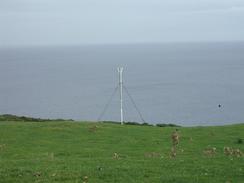
The Southern Upland Way joins a road, which it follows downhill into a gully by a caravan site. When the Southern Upland Way leaves off to the right continue straight on uphill along the road until it ends at the A1107 at Woodend. Turn left and walk eastwards along the A1107 as it heads uphill until a road is met on the left; turn left to follow this road as it heads eastwards for a couple of miles until it ends near Redheugh Farm, where it ends. At the farm continue straight on down a rough track that heads towards the top of the cliffs before curving to the right uphill. As the track curves starts to curve to the left leave it and head uphill to the southeast, aiming for a transmission mast visible ahead. Just before the mast is reached a road is met; join this road and turn left to follow it northeastwards to the farm at Dowlaw.
When the road ends continue straight on along a track that heads eastwards before curving to head southwards to reach the farm at Lumsdaine. When the public road restarts at Lumsdaine turn left down another track that heads northeastwards for a short distance before ending at a T-junction with another track; at the junction turn right and when the track ends turn left to head northeastwards along a path towards the top of a hill. This hill marks the start of a measured mile and has a marker on top of it; I attempted to follow the line of the measured mile towards the other marker a mile away to the east, but there were several deep gullies in the way and at this stage I floundered around on the moorland, trying to find the best way through. Eventually I walked to the north of Coldingham Loch to reach the other marker, and I then descended downhill to meet a track at Pettico Wick.
Join the track and follow it as it winds uphill to reach the very top of St Abb's Head. At the top of the head a path leads off along the edge of the cliffs downhill, before skirting inland past Kirk Hill to reach Horsecastle Bay. The path climbs up over the Wuddy and then skirts the edge of the cliffs past Starney Bay, before it curves to the right to head south past a wall and some woodland to reach the B6438 road. Turn left and follow the B6438 road eastwards past the village church and down into the little harbour. This walk ends at the car park in the harbour near the lifeboat station.
Distances
| From | To | Distance (m) | Ascent (ft) | Descent (ft) |
|---|---|---|---|---|
| Thorntonloch | Redheugh Farm | 6.7 | 1063 | 784 |
| Redheugh Farm | St Abb's Head | 7.1 | 1266 | 1250 |
| St Abb's Head | St Abb's | 1.6 | 361 | 659 |
This makes a total distance of 15.4 miles, with 2690 feet of ascent and 2693 feet of descent.
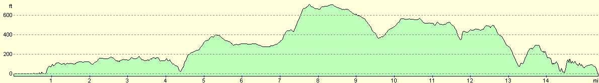
For more information on profiles, ascents and descents, see this page
Accommodation
We stayed at the Scoutscroft Holiday Center in Coldingham, Tel. 018907 71338, or email holidays@scoutscroft.co.uk and they have a website at www.scouscroft.co.uk. This was quite a nice site that cost us eleven pounds for the night, and had a good range of facilities. The last thing that it could be called is spartan. It was only a mile and a half from St Abbs, which meant that Sam will not need to drive far tomorrow morning to drop me off.
Disclaimer
Please note that I take no responsibility for anything that may happen when following these directions. If you intend to follow this route, then please use the relevant maps and check the route out before you go out. As always when walking, use common sense and you should be fine.
If you find any information on any of these routes that is inaccurate, or you wish to add anything, then please email me.
All images on this site are © of the author. Any reproduction, retransmissions, or republication of all or part of any document found on this site is expressly prohibited, unless the author has explicitly granted its prior written consent to so reproduce, retransmit, or republish the material. All other rights reserved.
Although this site includes links providing convenient direct access to other Internet sites, I do not endorse, approve, certify or make warranties or representations as to the accuracy of the information on these sites.
And finally, enjoy your walking!
This walk was mentioned in the following routes:
| My walk around the coastline of Britain |
Nearby walks
| # | Title | Walk length (miles) |
|---|---|---|
| 224 | Auldhame to Thorntonloch | 20.6 |
|
|

|