Walk #226: St Abbs to Berwick-on-Tweed
 |
 |
|
General Data
| Date Walked | 05/10/2002 |
| County | Borders, Northumberland |
| Start Location | St Abbs Harbour |
| End Location | Spittal |
| Start time | 08.58 |
| End time | 17.30 |
| Distance | 16.8 miles |
| Description | This was a nice walk following the Berwickshire Coast Path around the cliffs between St Abbs and Berwick-on-Tweed. |
| Pack | Today I carried my 30-litre Karrimor HotRock rucksack, which was filled with my packed lunch, waterproof coat, water bottle and a couple of spare shirts, together with the usual assortment of odds and ends. |
| Condition | The main problem today was with my left calf, which was aching after an uncomfortable night's sleep last night. My left Achilles tendon that had been aching yesterday was okay today except for a few short periods of discomfort. I also had a little problem with my right shoulder, which I out down to having my walkman hanging off the rucksack strap on that side. I have no new blisters, which is probably down to the fact that I wore my Pennine Way-era boots. |
| Weather | The weather today was cloudy with only occasional glimpses of the sun, with a strong wind making me cold on exposed cliffs. |
| OS map | Landranger number 67 (Duns, Dunbar & Eyemouth area) and Landranger number 75 (Berwick-Upon-Tweed & surrounding area) |
 |
 |
|
 |
 |
|
Map of the walk
Maps courtesy of Google Maps. Route for indicative purposes only, and may have been plotted after the walk. Please let me have comments on what you think of this new format. For a detailed table of timings for this walk, please see the table file.
 |
Notes
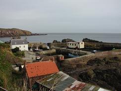
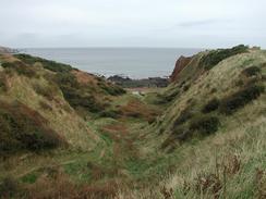
A massive hangover greeted me this morning, a consequence of the copious amounts of alcohol that I had drunk the previous night. Sam was in pretty much the same situation, and as a result I started today's walk a little later than I had intended. St Abbs Harbour was quite busy when we arrived, and it was nice to see the area so busy, albeit mostly with scuba divers. The initial short stretch of walk was not in the least bit taxing, and I enjoyed the stroll over the cliffs to Coldingham Bay, which was quite an attractive stretch of beach. From Coldingham Bay I had a decision; the Ordnance Survey map showed a path heading over the headland to Linkim Shore, but instead of following this I decided to walk along the rocky foreshore instead, which proved east enough to do. At Linkim Shore I picked up the path once more as it climbed through a deep-sided gully onto the top of the cliffs, and then on into the village of Eyemouth. Near Eyemouth I came across an elderly man who was walking his dog, and he told me to look up a friend of his when I reached Mallaig. That seems such a long way away that it seemed almost farcical - I have not even completed 100 miles yet, and people are telling me to remember things for when I reached over 4,000!
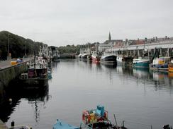
Eyemouth is a pretty little village, and it is apparently much nicer since the harbour was upgraded in 1964. New building works were ongoing on the eastern side of the Eye Burn that divides the town into two, and it was near here that I met Sam for a little over half an hour. We went through the town to find somewhere to eat, but most of the cafes and chip shops had not yet opened for the day. Because of this we ended up buying some food in a supermarket in the town and ravenously ate this as we walked around. I nipped into the Tourist Information Office, which is housed in a grand building in the town, and the lady there kindly gave us a fiver for the charity. In the office I found a leaflet for the Berwickshire Coastal Path, which leads from Eyemouth to Burnmouth and on to Berwick upon Tweed, the rest of my day's walk. South of Burnmouth the maps show no path and I had been planning to walk along the A1(T) for this stretch, so I was exceedingly glad that a path had been opened. I purchased a leaflet on the walk, and set off happier that the day was not going to involve a long road plod.
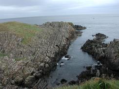
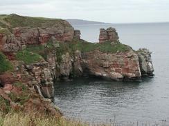
I soon regained the cliffs to the southeast of Eyemouth, and the path was easy to follow as it climbed uphill between the cliffs and a seemingly never-ending golf course. In a couple of places the path had been eroded away, and it skirted through a stone wall and onto the golf course to avoid these places. At the highest point of the cliffs at Fancove Head I got some superb views back down the cliffs, which were exceedingly rugged and seemed higher than the 103 metres marked on the map. A short distance further on I came across a few workmen and a lorry busy working renovating the path; it was the first piece of footpath maintenance that I have seen on the trip so far, and it was a good sign. From Fancove Head the path followed the cliffs southwards until I was nearly at Burnmouth. I was getting slightly tired by this time, and so I decided to sit down on a bench where there were some brilliant views out to sea. After a few minutes I started to get fidgety and bored, so I set off down the path and into Burnmouth. The path was rudely deposited onto a narrow road and I found it difficult to know which way to go, but I decided to head downhill along the road, which was exceedingly narrow and had a long hairpin bend in it before it eventually reached the small harbour at Burnmouth.
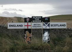
Burnmouth itself was quite pretty, although the cliffs towered above the village and I was slightly concerned about how I would get back onto the top of the cliffs, where I assumed that the path went. After walking along the road for a short distance towards the hamlet of Ross I found a sign that showed that the path went up the cliffs beside a house - this stretch of paths was a nice walk, although it was quite steep in places, and I soon found myself at the top of the cliffs. For the rest of the way to Berwick-upon-Tweed I was sandwiched between the edge of the cliffs and the East Coast Main Railway Line, which runs very close to the edge. In places the path was literally sandwiched a few feet from the railway line and the edge of the cliffs, and in others it soared over the railway line as the latter went into cuttings. It made for an exhilarating walk, and one that I enjoyed immensely. I eventually reached the English / Scottish border, and I realised that I had reached the first significant milestone of the entire walk - for the next few thousand miles I shall be in England, and I cannot imagine when I shall next cross the border and re-enter Scotland, as it feels like such a long way away. I walked across a field from the path at the edge of the cliffs to gain access to the railway line, where there is a famous sign marking the border between the two countries.
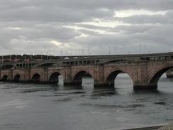
The rest of the walk southeastwards to Berwick-upon-Tweed was quite straightforward, and the going was flatter than it had been on the Scottish stretch. At Needles Eye the railway line finally left the coast, and I walked on alone along the edge of the cliffs and past another ubiquitous golf course, thinking about nothing and just enjoying the stroll. I soon found myself passing the caravan Park at Sharpers Head, and a little further on I reached the car park by the breakwater that guards the mouth of the River Tweed. I walked along roads past the magnificent walls of the town, and indeed walked along the top of them for a short stretch until I reached the 1611-built Berwick bridge, an attractive bridge made up of many small arches across the river. From the southern side of the bridge I only had about a mile left to get to the campsite where Sam was waiting for me, but I took my time and savoured the walk. On the way I noticed a chip shop, at which we bought some fish and chips later on - the first of the trip, and I was surprised to hear that the Scottish and Borders accents were intermingled with Geordie accents - a sure sign that we were in the northeast of England.
Directions
For the entirity of this walk between St Abbs and Berwick upon Tweed I followed the Berwickshire Coastal Path, which was not marked on the Ordnance Survey maps that I had. however a good brochure is available in the form of the Berwickshore Coastal Path brochure, available from local Tourist Information office in Eyemouth.
This walk starts off at St Abbs Harbour, in the little village of St Abbs. Leave the harbour and head south through the village, climbing uphill and onto the edge of the cliffs, from where a path heads south along the edge of the cliffs until the pretty and compact Coldingham Bay is reached. Descend downhill towards the beach and then up onto the cliffs on the southern side, descending to cross the Millown burn at the pebble beach at Millown Shore. I then followed the rocky foreshore around past Yellow Craig to reach Linkim Shore, although if the tide is high this may be impassable. At Limkin shore a path heads up onto the top of the cliffs through a steep-sided gully, and once the top of the cliffs are reached turn left and follow the path along the edge of the cliffs to Hairy Ness and then into the village of Eyemouth.
Go through Eyemouth to reach a bridge over Eye Water, and then once on the other side head northwards along the eastern bank of the river. When a road is met follow it past the harbour until it turns sharply to the right; here a path continues straight on to the cliffs at Nestends. The path slowly climbs as it heads southwards along the cliffs, passing Scout Point and Horse Head before eventually reaching a summit at Fancove Head, with some superb views available down the high cliffs. From Fancove Head the path continues on southwards as the cliffs slowly descend towards the tiny village of Burnmouth. It eventually merges at a road; turn left down this road as it goes down a hairpin and ends at the tiny Burnmouth Harbour. AT the harbour continue on southeastwards along a road towards the tiny hamlet of Ross, before which you turn right beside a house to climb up the cliffs on a steep path.
At the top of the cliffs turn left and follow the path as it heads southwards along the edge of the cliffs. After a short distance the railway line comes in from the right, and for the next few miles the path is sandwiched perilously between the clifftop and the railway line. Follow the path as it heads on across the Scotland / England border, and when the railway line curves away to the right at Needles Eye continue on along the top of the cliffs. The path passes a golf course before reaching a caravan park at Sharper's Head; continue on along the clifftop for a little under a mile as it winds around headlands and emerges at a car park by the jetty on the northern side of the River Tweed. Turn right and walk westwards along the road; when this ends at the town wall climb up onto the wall and follow it along the river until the medieval bridge over the river is reached. Cross this bridge onto the southern side of the river, and then turn left to walk southeastwards along roads past the docks. This walk ends at the Seaview caravan club site in Spittal, which is sandwiched between the railway line and the road.
Distances
| From | To | Distance (m) | Ascent (ft) | Descent (ft) |
|---|---|---|---|---|
| St Abb's | Eyemouth | 4.4 | 787 | 748 |
| Eyemouth | Burnmouth | 3.4 | 659 | 456 |
| Burnmouth | Spittal | 9.0 | 2165 | 2369 |
This makes a total distance of 16.8 miles, with 3611 feet of ascent and 3573 feet of descent.
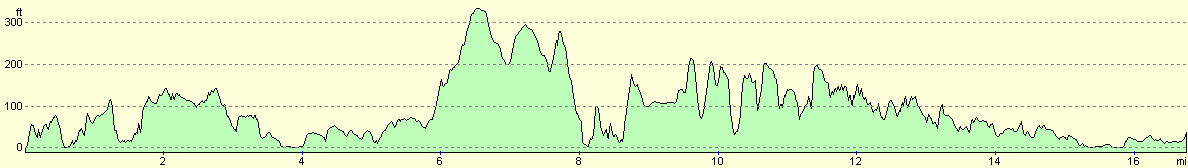
For more information on profiles, ascents and descents, see this page
Accommodation
We stayed in the Seaview caravan club site at Spittal, just to the south of Berwick-on-Tweed. This was a very nice site, and the toilet facilities were excellent. Our pitch was right beside the east coast main railway line, but this did not disturb us at all.
Disclaimer
Please note that I take no responsibility for anything that may happen when following these directions. If you intend to follow this route, then please use the relevant maps and check the route out before you go out. As always when walking, use common sense and you should be fine.
If you find any information on any of these routes that is inaccurate, or you wish to add anything, then please email me.
All images on this site are © of the author. Any reproduction, retransmissions, or republication of all or part of any document found on this site is expressly prohibited, unless the author has explicitly granted its prior written consent to so reproduce, retransmit, or republish the material. All other rights reserved.
Although this site includes links providing convenient direct access to other Internet sites, I do not endorse, approve, certify or make warranties or representations as to the accuracy of the information on these sites.
And finally, enjoy your walking!
This walk was mentioned in the following routes:
| My walk around the coastline of Britain |
Nearby walks
| # | Title | Walk length (miles) |
|---|---|---|
| 225 | Thorntonloch to St Abbs | 15.4 |
|
|

|