Walk #227: Spittal to Ross Links
 |
 |
|
General Data
| Date Walked | 06/10/2002 |
| County | Northumberland |
| Start Location | Spittal |
| End Location | Ross Links |
| Start time | 07.35 |
| End time | 14.30 |
| Distance | 15.0 miles |
| Description | This was a nice walk on and off footpaths past Holy Island. |
| Pack | Today I carried my 30-litre Karrimor HotRock rucksack, which was filled with my packed lunch, waterproof coat, water bottle and a couple of spare shirts, together with the usual assortment of odds and ends. |
| Condition | Unfortunately I suffered from a massive headache all day which was so fierce that at times the vision in my right eye was blurring. This caused me to consider cutting the walk short at the road leading to Holy Island, but I continued on for a few miles beyond there. Aside from this I had the problem with my left calf that had yesterday but was otherwise fine, with no new blisters to report. |
| Weather | The weather today was absolutely superb. It was less windy than it had been for the previous couple of days, and the sky was mostly sunny with only occasional cloud. Initially it was quite cold, but it soon warmed up enough for me to take my fleece off. |
| OS map | Landranger number 75 (Berwick-Upon-Tweed & surrounding area) |
 |
 |
|
 |
 |
|
Map of the walk
Maps courtesy of Google Maps. Route for indicative purposes only, and may have been plotted after the walk. Please let me have comments on what you think of this new format. For a detailed table of timings for this walk, please see the table file.
 |
Notes
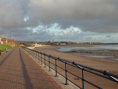
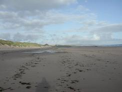
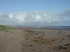
The initial stretch of this walk fortunately proved to be easy going, and I followed a cycle path, initially along a promenade and then along the clifftop, south from Berwick-upon-Tweed. The views were very nice, and I enjoyed the walk despite the headache, which had stubbornly refused to go away. At Cocklawburn Beach I descended form the road onto the beach, and I followed this for many more miles, excitedly watching Holy Island get larger as I approached it.
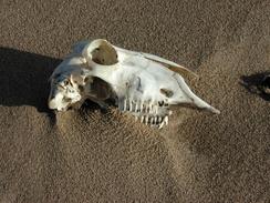
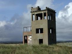
Towards the southeastern end of Cheswick Sands there were warning notices about unexploded bombs left over from the Second World War, when this area was a big army base. There were the ruinous remnants of several blockhouses and an observation post that I could see, although I must admit I was disappointed not to find any bombs, or even any shrapnel from exploded bombs. It would certainly have added some excitement to what was proving to be a fairly long and uneventful stroll along the sands.
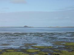
I had started the walk early this morning, as Sam wanted to get to Holy Island. The Island is accessible via a tidal causeway, and the tides were such that they would only allow her to get there between 07.00 and 13.00. Unfortunately when she got there she realised that the castle did not open until 10.30, so she spent some time looking around while she waited. This was far from ideal, but whilst she waited she went for a little walk around the island, which is apparently exceedingly beautiful. I myself had wondered whether or not to walk over onto the island, but I decided against it when I realised that it would be exceedingly tight for me to reach and cross the causeway in time before it closed, and that I would not have any time to look around. This was a shame, but as I intend to walk St Cuthbert's Way (which starts on Holy Island) sometime in the future, I shall get to see it anyway, so all is not lost. The Island is steeped n history, and Saint Aidan established the first English Diocese here in AD635. The castle on the island is privately owned but can be visited, and was built in around 1550.
Later on in the walk I left footpaths and made my own way around the coastline. As there were no footpaths this involved climbing over fences and clambering around, over or through hedges that also rather constrained progress. Near Elwick I came across a couple walking towards me in the next field, and as they crossed the fence between the two fields the woman took a rather athletic tumble. Fortunately she was okay, and he turned out to be a local farm worker. Rather than admonish me for trespassing, he congratulated me on what I was doing and we had a nice long chat. I do not know if I will do much more of this off-path walking in England - it is illegal and it does not seem right somehow.
When I woke up this morning I had a terrible skull-splitting headache. There were no headache tablets in the van, so I decided to hope that I would pass a shop on the way out of Berwick-upon-Tweed. I did not, and as the day went on my headache slowly got much worse until eventually I decided to cut the walk short and end it at Ross, about four mile short of where I had wanted to end it at Waren Mill. Because I was feeling so rotten progress was very slow, which also did not improve my morale one bit, and so cutting the walk short was probably a good idea.
Directions
This walk starts off at the Seaview caravan club site at Spittal, just to the south of Berwick-on-Tweed. Leave the caravan site and walk northeastwards along roads for a few hundred metres to reach the car park at Sandstell Point, at the southern side of the mouth of the River Tweed. At the point turn right and walk south along a promenade through Spittal until Bears Head, where the cliffs start. Just before the end of the promenade a path leads up onto the top of the cliffs, and here a cycle path can be joined. Walk southeastwards along the cycle path as it squeezes between the railway line and the edge of the cliffs - the going is reasonable underfoot, but in places the path is unsurfaced. At Sea House the path joins a road and continues along it; I walked onwards for a short distance towards Saltpan rocks and then headed down onto Cocklawburn Beach.
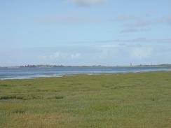
Instead of walking along the top of the cliffs I walked along the foreshore, heading to the southern end of the beach and then continuing on past the Near, Middle and Far Skerr's to reach the start of a long expanse of beach called the Cheswick Sands. Walk southeastwards along the beach for over three miles, passing Beachcomber House on the way. When the sand starts to become muddier head inland to a footpath that runs along the edge of the firmer land. This footpath soon reaches the South Low Drain, which it turns to follow inland until a little bridge is reached over the drain (note - do not attempt to follow the footpath across the drain at the point marked on the map - the mud looked quite dangerous to me). Cross the bridge, and on the other side turn left to follow the banking back to the footpath and onwards to Beal Point. Here the path follows the coast as it runs to head southwards, and after a few hundred metres the causeway and road over to Holy Island is reached.
Cross the causeway and continue on south along the footpath, following the St Cuthbert's Trail for a short distance. After a few hundred metres the footpath turns to the right to head inland, and after crossing Black Low on a bridge turn left down another footpath that heads southeastwards across fields; when this reaches a building turn right and walk the short distance across a field to the road in Fenham. Here turn left and walk down the road until it ends at the sea, and then turn right to enter fields. Follow the coast along, crossing the Mill Burn and heading on to the road and little car park at Lowmoor Point. Here turn right to walk south along the road until the farm at Fenham-le-Moor is reached. Immediately after the farm take a footpath that leads southeastwards; when this meets the coast leave it and start walking along the edge of the low cliffs southeastwards, passing Heather Law and climbing up White Hill. There are no stiles, so I was forced to climb or open gates to make progress.
The coast slowly curves around and passes the end of a track; continue on following the edge of the low cliffs past the strangely named Stinking Goat drain, until some trees are reached in fields to the right. Pass this tree line and then turn right to join a track that runs down the eastern side of the tree line. Follow the track for about a kilometre until it reaches a junction with another track near the farm at Ross, where this walk ends.
Distances
| From | To | Distance (m) | Ascent (ft) | Descent (ft) |
|---|---|---|---|---|
| Spittal | Holy Island Access | 8.5 | 456 | 492 |
| Holy Island Access | Ross | 6.5 | 253 | 233 |
This makes a total distance of 15.0 miles, with 709 feet of ascent and 725 feet of descent.
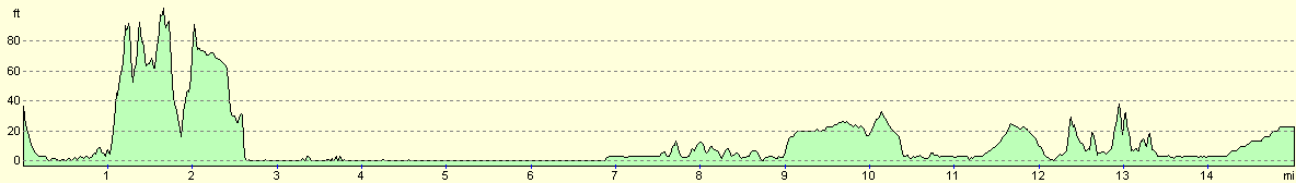
For more information on profiles, ascents and descents, see this page
Accommodation
We parked the van at the Waren caravan and camping park, at Bamburgh in Northumberland. This park cost us eleven pounds for the night and has a bar and restaurant on site. Again this site had unisex combined toilet and shower cubicles which I first encountered a couple of days ago and much prefer. The site has some lovely views over the sea and looked nice and appeared to be well cared for. For more details phone 01668 214366, or email waren@meadowhead.com. They have a website at www.meadowhead.co.uk/waren.
Disclaimer
Please note that I take no responsibility for anything that may happen when following these directions. If you intend to follow this route, then please use the relevant maps and check the route out before you go out. As always when walking, use common sense and you should be fine.
If you find any information on any of these routes that is inaccurate, or you wish to add anything, then please email me.
All images on this site are © of the author. Any reproduction, retransmissions, or republication of all or part of any document found on this site is expressly prohibited, unless the author has explicitly granted its prior written consent to so reproduce, retransmit, or republish the material. All other rights reserved.
Although this site includes links providing convenient direct access to other Internet sites, I do not endorse, approve, certify or make warranties or representations as to the accuracy of the information on these sites.
And finally, enjoy your walking!
This walk was mentioned in the following routes:
| My walk around the coastline of Britain |
Nearby walks
| # | Title | Walk length (miles) |
|---|---|---|
| 226 | St Abbs to Berwick-on-Tweed | 16.8 |
|
|

|