Walk #228: Ross to Dunstan Steads
 |
 |
|
General Data
| Date Walked | 07/10/2002 |
| County | Northumberland |
| Start Location | Ross Links |
| End Location | Dunstan Steads |
| Start time | 08.38 |
| End time | 15.32 |
| Distance | 18.2 miles |
| Description | This walk was a four mile road walk followed by a long series of beach walks southwards past the spectacular Bamburgh Castle and the Farne Islands. |
| Pack | Today I carried my 30-litre Karrimor HotRock rucksack, which was filled with my packed lunch, waterproof coat, water bottle and a couple of spare shirts, together with the usual assortment of odds and ends. |
| Condition | I feel absolutely fine after this walk. I have and no major problems, either with my feet, calves or ankles. This is a major change after yesterday, and made it a much more enjoyable walk. |
| Weather | It was mainly cloudy today, with occasional sunny periods. There was a slight breeze that meant that I was a little chilly on exposed cliff tops, but aside from this I was generally warm enough. Yet again there was no sign of any rain. |
| OS map | Landranger number 75 (Berwick-Upon-Tweed & surrounding area) |
 |
 |
|
 |
 |
|
Map of the walk
Maps courtesy of Google Maps. Route for indicative purposes only, and may have been plotted after the walk. Please let me have comments on what you think of this new format. For a detailed table of timings for this walk, please see the table file.
 |
 |
|
 |
Notes
This was probably the best day's walking that I have enjoyed so far this trip, and it was made so by the great views that were available along Bamburgh Beach with the Farne Islands visible to the left and Bamburgh Castle to the right. This was a truly spectacular walk, and I savoured every moment as I motored along. Fortunately when I woke up this morning the headache that plagued me throughout yesterday had disappeared, and this alone had put me into a much better and joyful disposition.
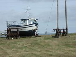
From Ross, where I finished yesterday's walk, I could have walked out to the beach at Ross Links and then around the northern and western ends of Budle Bay to Waren Mill. I did not fancy this stretch of walk, however, so I decided to walk along roads to reach the same place. This was a fairly uninteresting walk, although there were some nice views, and near Easington Grange I came across a farmer's four wheel buggy with four collie dogs sitting in the back - without the driver on it looked as though the dogs had been driving it!
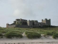
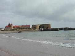
I was massively impressed by Bamburgh Castle, and the walk along the beach beneath it was wonderful, particularly in the sunshine. Sam visited the castle today and had been massively impressed by it, and I wish that I could have had the opportunity to do so - another thing to add to my ever-increasing list of places to visit after the trip. The castle was mainly built in the 18th and 19th centuries, when it was used as a school to train servant girls, although it is on a much older site, the first fortifications being built on the site in AD547 by King Ida. The castle looks even more impressive as the low cliffs increase the hright to the top of the walls to 150 feet.
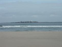
From Budle Point I could see the Farne Islands seemingly just a short distance out to sea to the east. These islands are world-famous, and there are about thirty of them, totalling about 80 acres of land. There are a couple of lighthouses on the islands, one of which I could see clearly, and the other less so as it was much further out. St Cuthbert lived on one of the islands for a period when he found Holy Island too busy, and ever since they have been a place of retreat for religious people.
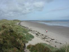
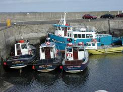
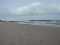
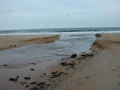
Beadnell was quite a nice little village, and I enjoyed looking at the tiny little harbour that was almost completely dry when I passed it. The rest of the days walk was mostly along lovely sandy beaches with only a couple of little headlands interrupting the stroll. The only downside was at Embleton Burn, where I got my feet wet as I crossed it. Whilst this was enough to get my feet wet it did not dampen my spirits, and in a slightly sadistic way I actually enjoyed squelching along the beach with wet feet. I had arranged to meet Sam at the car park behind the sand dunes at Dunstan Steads, and as I approached I saw a small boat being tossed up and nearly overturned by the strong breakers that were rolling in to the beach. This made a stunning sight with the ruins of Dunstanburgh Castle behind it, and it was worth stopping just to watch the boat being thrown about.
After the first week of walking it is perhaps time for me to evaluate the events so far. Generally I have enjoyed the walk, and I am now well into my stride. The weather has been excellent for the time of year, with only about an hours rain in a whole week of walking. It is also nice to be on schedule, and I can only hope that this continues to be the case. If all the remaining days of the coastwalk are going to be like this then I am in for a truly memorable and unforgettable trip - today really was a great day, and it is definitely a walk that I would like to do again sometime in the future.
Directions
This walk starts off at the track leading from the farm at Ross towards Ross Links. Follow the track to Ross Farm where it becomes a road, and then on westwards for about a mile until it ends at a T-junction with another road. At the junction turn left to head southwards for a little over a mile, passing Easington Grange and slowly climbing uphill. Near Cragmill the road curves to the left to head eastwards for a little under three kilometres until it ends at a T-junction with the B1342 road at Waren Mill. At the junction turn left and follow the B1342 as it crosses over the Waren Burn and leads on northeastwards for about a kilometre beside the southern shore of Budle Bay.
Shortly after a track leads off to the left take a footpath that leads off to the left, angling across fields uphill to the northeast for a short distance until it ends at a track near the farm at Heather Cotts. Turn left down the track and pass the farm, and continue on northwards until the foreshore is reached. Turn right and walk northeastwards along the foreshore to Budle Point, and then on eastwards past a lighthouse and on to Harkess Rocks. Here the foreshore became less rocky and a glorious stretch of beach began, which took me under the impressive ramparts of Bamburgh Castle. Continue southeastwards along the beach for another few miles, passing Greenhill Rocks and Monks House Rocks before the sand ends and rocks take over. When it does climb up off the beach and join the B1340 road, and turn left to follow this to a roundabout in Seahouses.
At the roundabout turn left and walk to the harbour, and then join a footpath that heads southeastwards to North Sunderland Point. The footpath then curves around to the right, and when it does descend down onto the beach and follow it southwards past the Annstead Rocks and Collith Hole to reach the little village of Beadnell. Climb up onto the road that skirts the shoreline and walk south through the village until Beadnell Harbour is reached at the southern end of the village. Pass the harbour and then descend down onto the beach at the northern end of Beadnell Bay, and then walk south along the beach until it ends at Snook Point. I crossed over this little headland to gain access to the next little bay, curiously called Football Hole.
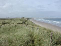
When the southern end of Football Bay is reached climb up onto the fields and walk to the end of the Newton Point, and then on southwestwards along the edge of the fields to the little village of Low Newton-by-the-Sea. Here rejoin the beach, and follow it as it heads south around Newton Haven and on into Embleton Bay; this walk ends at a car park at Dunstan Steads, at the southern end of Embleton Bay.
Distances
| From | To | Distance (m) | Ascent (ft) | Descent (ft) |
|---|---|---|---|---|
| Ross | Waren Mill | 4.0 | 177 | 197 |
| Waren Mill | Seahouses | 6.4 | 256 | 223 |
| Seahouses | Dunstan Steads | 7.8 | 361 | 351 |
This makes a total distance of 18.2 miles, with 794 feet of ascent and 771 feet of descent.
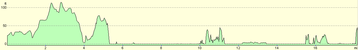
For more information on profiles, ascents and descents, see this page
Accommodation
We stayed at the camping and caravan club site at Dunstan. It cost £10.30 for the night, and the facilities were quite reasonable. The telephone number is 01665 576310.
Disclaimer
Please note that I take no responsibility for anything that may happen when following these directions. If you intend to follow this route, then please use the relevant maps and check the route out before you go out. As always when walking, use common sense and you should be fine.
If you find any information on any of these routes that is inaccurate, or you wish to add anything, then please email me.
All images on this site are © of the author. Any reproduction, retransmissions, or republication of all or part of any document found on this site is expressly prohibited, unless the author has explicitly granted its prior written consent to so reproduce, retransmit, or republish the material. All other rights reserved.
Although this site includes links providing convenient direct access to other Internet sites, I do not endorse, approve, certify or make warranties or representations as to the accuracy of the information on these sites.
And finally, enjoy your walking!
This walk was mentioned in the following routes:
| My walk around the coastline of Britain |
Nearby walks
| # | Title | Walk length (miles) |
|---|---|---|
| 227 | Spittal to Ross Links | 15.0 |
|
|

|