Walk #377: Caswell to Port Eynon
 |
 |
|
General Data
| Date Walked | 08/03/2003 |
| County | West Glamorgan |
| Start Location | Caswell |
| End Location | Port Eynon |
| Start time | 08.50 |
| End time | 13.37 |
| Distance | 11.3 miles |
| Description | This was a short and very annoying day, and a walk that should have been lovely was spoilt by some fairly atrocious wet weather. |
| Pack | Today I carried my 30-litre Karrimor HotRock rucksack, which was filled with my packed lunch, waterproof leggings, water bottle and a couple of spare shirts, together with the usual assortment of odds and ends. |
| Condition | The main thing after this walk is that I feel like I am coming down with a cold - my throat feels slightly raw and my nose is snuffley. This is not too serious at the moment, but if I have another couple of wet days then it could well develop into a full cold. Aside from this I am fine, and have no problems to report with my body, which is to be expected after such a short walk. |
| Weather | Today was yet another wet and dreary day. It rained continuously whilst I was walking, and the rain was accompanied by a strong westerly wind that gusted occasionally. There was no sign of he sun, and although the temperature was quite mild the wind reduced this temperature because of wind-chill. All in all another absolutely awful day, and unfortunately the long-range weather forecast states that the coming week will have yet more of these. |
| OS map | Landranger number 159 (Swansea & Gower, Carmarthen) |
 |
 |
|
Map of the walk
Maps courtesy of Google Maps. Route for indicative purposes only, and may have been plotted after the walk. Please let me have comments on what you think of this new format. For a detailed table of timings for this walk, please see the table file.
Notes
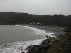
This was really a most disappointing day for a number of reasons. The main and most obvious reason was the weather, which was not only wet but also extremely windy, and this made the walk highly unenjoyable, particularly on the cliffs. As I was walking along the beach to Oxwich the wind was blowing straight into my face, the rain drops feeling like little balls of lead as they blew into my face, stinging my cheeks and forehead. This weather was making me thoroughly depressed as I walked along, and the noise from the wind was such that I could not even listen to my Walkman properly, so I had nothing to distract me from the weather.
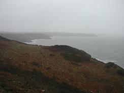
Once I got to Oxwich I decided that walking along the cliffs to Oxwich Point would be silly as I was so cold and not a bit wet, so I decided to cut cross-country to Port Eynon via Slade and Horton. I do not see this as cheating, as the weather was so bad that I had not felt safe on the cliff tops earlier in the walk, especially as the path was so muddy. However I am annoyed at missing out on the lovely scenery of this part of the Gower, but the weather had spoilt any views I may have had anyway.
A far worse thing happened today, however. For some time my digital camera had been playing up, and although I took a couple of photos at Caswell at the beginning of this walk I had left my camera inside my coat to keep it dry. When I reached the sand dunes at Pennard burrows there was a slight lull in the rain, and so I got my camera out to take some photos only to find that the CCD (the part of the camera that changes light from the lens into a digital image) was not working properly. I therefore put that camera away and took photos with my backup film camera. I later discovered that the camera sometimes, rarely, worked properly, but it looked as though something had gone majorly wrong with it. This is very annoying, but I have taken about 1,200 photographs with the camera, which is not a bad total.
I had intended to walk as far as Worms Head today, but I decided that because of everything that had happened it would be best if I cut the walk short. Sam could not get the van down to Oxwich, so we arranged to meet in Port Eynon. Even though the inland route that I chose to do was more sheltered than a cliff-top route would have been, I was still getting very cold through my wet clothes - although I was not wet to the skin - the wet clothes on my top layers let the cold wind seep right through to my body. Although cutting the walk short is annoying and reduces my average mileage quite considerably, I have little doubt that it was the right thing to do because of the weather.
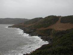
The area stretching westwards from the sand dunes at Pennard Burrows to Oxwich is extremely nice, and even in the rain it was quite beautiful. In the burrows I met a group of bedraggled geology students, all carrying rock hammers and tapping away at the cliff faces. Some of them looked really unhappy, and I think that I must have had about the same expression on my face. The dunes were very nice, and on a sunny day this part of the walk would have been absolutely wonderful. I was unsure about where I was going to be able to cross the little river that feeds out by the burrows, and I had been planning to walk up as far as the A4118 main road if that was the first crossing point. Fortunately from the tops of the dunes I could see some stepping-stones, and so I made my way down to these can crossed the stream over them. The stream would probably be easy to ford, but there was no way that I wanted to get even wetter than I already was.
Once I had reached Port Eynon I found the van easily in the car park beside the camp ground in which we were going to be spending the night. Sam was not in the van, but she had kindly laid out some clean clothes for me and so I spent the first few minutes stripping off and getting dressed into some warm, dry clothes and hanging up my damp and wet ones. I wondered where Sam was, but as we did not have mobile reception there was little I could do so I ate my lunch as I sat and waited. Rather typically as I ate the rain subsided and stopped, althouhg there was still no sign of any sun, and so the rest of the afternoon was mainly dry. Half an hour later Sam turned up - she had been walking along the beach to meet me, but she had not met me as I had walked inland to the van. Once she had arrived we drove into Swansea so that we could visit a camera shop. We went into the Jessops in the city centre, and it turned out that it would cost thirty-five pounds just to send my camera away for repair, and the repair would cost at least one hundred pounds on top of that. I would have been prepared to pay that much, but it also turned out that it could take up to three months to come back - an unacceptable period to be without my camera on a long trip such as this. I was therefore virtually forced to buy a new camera, and I chose to upgrade and get an Olympus 5050, which is far superior to my old model (which was a good camera in itself). Once I had chosen the model I wanted (I needed it to be able to be run off AA batteries, use SmartMedia cards and have optical zoom and USB) we went around to a local newsagents and bought a camera magazine. As Jessops price-match we fond a camera that was over ninety pounds cheaper than the Jessops price, which was quite a good deal. This all took a couple of hours, and it was six by the time that we got back to Port Eynon - and thus an early end to a walk had become a long day. We went to the local pub for a couple of drinks in the evening, and as I did not feel very hungry we shared a basket of chips in the pub and did not have a meal.
Tomorrow promises to be wet once again, and this is unfortunate as he next stretch of the Gower to Worms Head is meant to be by far the best. Fortunately it sounds as if the rain will not be as heavy or prolonged as it was today, and so I may be able to keep a little dryer. Hopefully the wind will have died down as well, as this made the rain so much more hard to cope with.
Directions
This walk starts off at the car park in Caswell, which is a few miles to the west of Mumbles Head. Leave the car park and turn right to head westwards along the road, following it as it heads uphill. When the road curves to the right take a footpath that leads off to the left, descending down into a valley where a junction is met with another footpath. Turn left down this new footpath that almost immediately meets the coast, and follow it around to Pwlldu Bay. Cross the bridge over a stream and then head uphill along another footpath that heads westwards towards High Pennard. From here head south along another footpath that passes around Pwlldu Head before turning to head northwestwards to reach a track at Hunts Farm. Turn left own this track and it soon becomes a public road that leads to a roundabout in the village of Southgate.
At the roundabout turn left and follow a bridleway that heads along westwards near the top of the cliffs and leads to Pennard Burrows. Descend through the dunes of the barrows to Pennard Pill, the river that runs in the valley. At the bottom of the valley some stepping-stones lead over the pill, and these can be used to cross the pill. On the other side turn left and join a footpath that climbs uphill over Great Tor, before descending down on the western side of the Tor to join the beach. Head westwards along the beach until a stream is met. Walk upstream for a short distance to a bridge that crosses the stream, and on the other side continue southwestwards along the beach in front of Oxwich Burrows until the little village of Oxwich is reached.
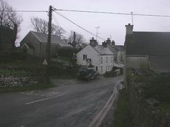
From Oxwich I took an inland route and not a coastal route; as a result of this you may want to follow another route and not the one that I describe here. Join the road in Oxwich and turn right to head northwestwards past some public toilets until a crossroads is met. At the crossroads turn left to head uphill westwards along another road. At a T-junction turn left along another road and follow it through Oxwich Green and then westwards into Slade. When the road ends in Slade continue on westwards along a track that ends at a farm, and when it ends continue on across fields for a little under a kilometre until it end at a road to the north of Horton. Turn left down this road into the village, and then turn left once more and head downhill towards the coast. At the bottom of the village a footpath leads off along a track westwards from a car park, and this track ends at the A4118 road in Port Eynon. At the A4118 road turn left down the road to the roundabout at the end of the road in the village, where this walk ends.
Distances
| From | To | Distance (m) | Ascent (ft) | Descent (ft) |
|---|---|---|---|---|
| Caswell | Oxwich | 8.3 | 1283 | 1358 |
| Oxwich | Port-Eynon | 3.0 | 387 | 348 |
This makes a total distance of 11.3 miles, with 1670 feet of ascent and 1706 feet of descent.
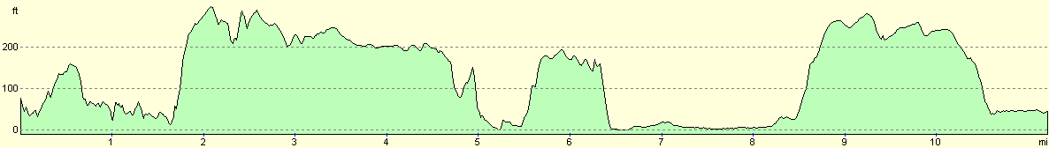
For more information on profiles, ascents and descents, see this page
Accommodation
We spent the night at the Carreglwd camping and caravan park at Port Eynon. They can be contacted on (01792) 390765, or by email at camping@porteynon.com. The site cost us five pounds for the night as the toilet block was being renovated.
Disclaimer
Please note that I take no responsibility for anything that may happen when following these directions. If you intend to follow this route, then please use the relevant maps and check the route out before you go out. As always when walking, use common sense and you should be fine.
If you find any information on any of these routes that is inaccurate, or you wish to add anything, then please email me.
All images on this site are © of the author. Any reproduction, retransmissions, or republication of all or part of any document found on this site is expressly prohibited, unless the author has explicitly granted its prior written consent to so reproduce, retransmit, or republish the material. All other rights reserved.
Although this site includes links providing convenient direct access to other Internet sites, I do not endorse, approve, certify or make warranties or representations as to the accuracy of the information on these sites.
And finally, enjoy your walking!
This walk was mentioned in the following routes:
| My walk around the coastline of Britain |
Nearby walks
| # | Title | Walk length (miles) |
|---|---|---|
| 376 | Port Talbot to Caswell | 16.0 |
| 378 | Port Eynon to Landimore | 18.6 |
| 379 | Landimore to Pwll | 19.7 |
|
|

|