Walk #229: Dunstan Steads to Amble
 |
 |
|
General Data
| Date Walked | 08/10/2002 |
| County | Northumberland |
| Start Location | Dunstan Steads |
| End Location | Amble |
| Start time | 08.35 |
| End time | 14.59 |
| Distance | 15.5 miles |
| Description | This walk started off with nice views of Dunstanburgh Castle, and ended with views of Warkworth Castle. In between was a mixture of beach and path walking which made for a very varied day. |
| Pack | Today I carried my 30-litre Karrimor HotRock rucksack, which was filled with my packed lunch, waterproof coat, water bottle and a couple of spare shirts, together with the usual assortment of odds and ends. |
| Condition | I am absolutely fine after this walk, and I have no problems to report aside from the fact that my right shoulder ached a little once again, but this was nothing that I could really complain about. |
| Weather | The main feature of the weather today was the wind, which was quite fierce and was a directly into my face on the journey along Alnmouth Bay. Above my head there was cloud, sometimes thin and occasional quite thick, but there was thankfully yet again no sign of any rain. How long can my luck last? The temperature today was not too bad, but the gusts of wind seemed to cut right through me anyway and make it feel much cooler than it actually was. |
| OS map | Landranger number 75 (Berwick-Upon-Tweed & surrounding area) and Landranger number 81 (Alnwick, Morpeth & surrounding area) |
 |
 |
|
 |
 |
|
Map of the walk
Maps courtesy of Google Maps. Route for indicative purposes only, and may have been plotted after the walk. Please let me have comments on what you think of this new format. For a detailed table of timings for this walk, please see the table file.
 |
 |
|
Notes
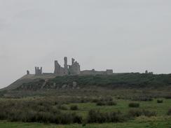
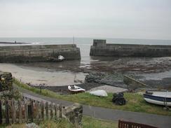
At the start of today's walk I came across the remains of the little boat that I had seen being tossed about in the surf at the end of yesterday's walk. This was lying on the sand and did not look in very good condition, as it was very near the spectacular ruins of the 14th century Dunstanburgh Castle. I soon passed these ruins that were literally breathtaking; they looked beautiful in the morning light. The path from the castle to Craster was well walked and the going was exceptionally easy, and I soon found myself peering down on the attractive little harbour in the village. Craster is famous for kippers that are smoked in the village, and as I climbed up out of the village I passed one of these, although it was not operating and no smoke was emerging from it. I was surprised to learn that Craster Harbour was only built in 1906, which makes it a relatively new harbour (it was built to export whinstone, which was used as a constituent part of tarmac). The local accent around here is lovely, and when I nipped into a shop to buy some chocolate I could not help but to talk to the lady so that I could hear more of her voice.
From Craster I followed a clifftop footpath that skirted right by the edge of the cliffs southwards to Sugar Sands. This walk was a wild and lovely walk with some nice views along and down the cliffs, with Dunstanburgh Castle visible in the distance behind me. The wind made the walk quite cold, however, and I was glad that I had my gloves with me to keep my hand warm. The path descended down quite steeply to a little stream by the attractive beach at Sugar Sands, before climbing up on the other side and continuing on along the cliffs to the village of Boulmer. Boulmer was a nice little village but it was exceedingly quiet, with no one about and the roads deserted. There were a few signs of life around the lifeboat station. The path continued on southwards from Boulmer towards Seaton Point, where the start of a two-mile stretch of beach down to the mouth of the River Aln started.
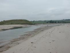
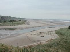
The highlight of this walk was the crossing of the River Aln, which I was lucky enough to be able to cross on foot near it's mouth and avoid a diversion inland to cross it. In her book, Spud Talbot-Ponsonby states that it is possible to cross the river for about an hour and a half at low tide. I did not know what time low tide was today, but the river looked quite low and easy to ford, so after chatting to a man who was exercising his dogs I sat down and took my socks off. The water was about knee deep and the current was quite strong, but progress across the river was easy except for the fact that my boots were sinking up to the ankles in sand on every step. I soon made it across to the other side, and I squelched my way up to the cross on a sand dune on the other side of the river to sit down, have lunch and put my socks back on.
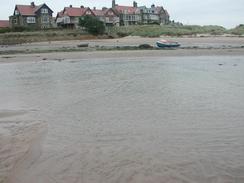
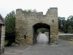
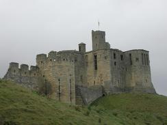
On the southern side of the River Aln there was another long and enjoyable beach walk down to the River Coque. I decided not to walk down to the very mouth of the river as there was no way across it and I would have to walk back again, so instead I walked along a footpath across a golf course into the village of Warkworth. This village was very pretty, and I had a quick look around the 14th century fortified bridge that spans the river beside the new road bridge. A little further on I came across the magnificent Warkworth Castle, built in the 12th and 14th century, and the castle in which Shakespeare set the play Henry IV. I was sorely tempted to go in and have a look around the castle, but time was pressing on and so I simply walked past it, pausing only to have a quick glance up the high walls of the castle.
I paused for a short period in Amble, and went into the tourist information centre in the town for a quick look around. I quite liked the town, and the square in front of the tourist information office was nice, with lots of interest to see. When I reached the campsite after 15.5 miles I found out that Sam had arrived a few minutes earlier after spending the day at Alnwick Castle. I felt really good and found it hard to believe that I had walked that far - I felt perfectly fine and could easily have walked much further. I chose not to however; as tomorrow's walk is scheduled to be only eleven miles long, and I will probably want to extend that anyway.
Directions
This walk starts off at the campsite at Dunstan Steads, which is just inland from the southern end of Embleton Bay. Leave the car park and head eastwards through the dunes to the beach, and then turn right for a couple of hundred metres to reach the southern end of the beach. When the foreshore becomes rocky climb up onto the top of the low cliffs, and join a footpath that heads southeastwards towards the ruins of Dunstanburgh Castle. The footpath skirts around the inland side of the castle, and then a very distinct path leads south for a little over a mile until the northern outskirts of the village of Craster is reached. Here the path joins the end of a road, which can be followed to the harbour in the village.
From the harbour climb uphill past a smokehouse, and then join a footpath that heads south along the top of the cliffs towards Cullernose Point. The path continues on past Rumbling Kern and descends down to Sugar Sands, where a footbridge takes you over a stream. On the other side of the stream the path climbs up onto the top of the cliffs once again, and continues on to a little headland at Longhoughton Steel, where it turns to head southwards for about a kilometre, becoming a track before it reaches the little village of Boulmer. When the track ends at a bend in a road beside a chapel in Boulmer continue straight on south down the road for a short distance until the lifeboat station is reached.
At the lifeboat station in Boulmer join a footpath that heads southwards past Boulmer Haven; near Marmouth Scars the footpath diverts inland cutting of a little piece of Seaton Point, but I continued around the point by walking on the foreshore. Instead of rejoining the footpath I continued along the foreshore as it became increasingly sandy, and this soon became a southwestwards walk past Marden Rocks to reach the mouth of the River Aln beside Alnmouth. Here there are two alternatives - if the tide is out it is possible to cross the River Aln near its mouth (the water came up to my knees); this has to be done with care, and my walking poles helped me keep my balance against the strong currents. If the tide is high or you do not fancy the crossing, then you will have a couple of miles diversion via the B1338 and A1068 to reach the southern side of the mouth of the river.
Once on the southern side of the River Aln continue on southwards along he wide, sandy beach. The beach is interrupted for a short distance by a rocky outcrop at Birling Carrs. A little over a kilometre south of Birling Carrs I diverted through the dunes to the right along a footpath; this meant that I did not have to walk down to the southern end of the beach and back again. Follow the footpath as it heads westwards past a golf course and a picnic area for a little under a kilometre until it ends at the A1068 road. Turn left and immediately cross the bridge over the River Coque, and immediately on the other side turn left down a minor road that skirts the western bank of the river. This road loops around and climbs uphill to rejoin the A1068 opposite Warkworth Castle. Turn left to join the A2068 road and follow it as it curves sharply to the left and joins the southern bank of the river.
Follow the A1068 as it heads southeastwards for about a mile, and when the road starts to curve away from the river turn left down a footpath that skirts the river until a marina is reached. The footpath skirts the inland side of the marina and then diverts inland before ending at a road. Turn left down this road and follow it into and through the town of Amble. Pass the central square and the tourist information building, before joining the main road in the town. This curves around to the right and then follow it southeastwards for about a kilometre until the Amble Links Holiday Park is reached on the right; the walk ends here.
Distances
| From | To | Distance (m) | Ascent (ft) | Descent (ft) |
|---|---|---|---|---|
| Dunstan Steads | Craster | 2.2 | 236 | 253 |
| Craster | Boulmer | 4.1 | 417 | 436 |
| Boulmer | River Aln | 3.1 | 98 | 105 |
| River Aln | Warkworth | 3.8 | 141 | 141 |
| Warkworth | Amble campsite | 2.3 | 144 | 118 |
This makes a total distance of 15.5 miles, with 1036 feet of ascent and 1053 feet of descent.
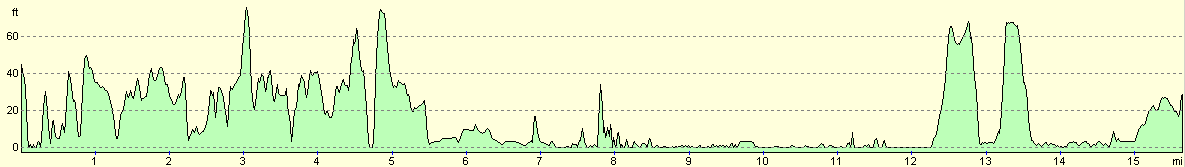
For more information on profiles, ascents and descents, see this page
Accommodation
We stayed at the Amble Links Holiday Park, which is on Links Road, Amble, Northumberland, Telephone 01665 710530, and email amble@linksholidaypark.fsnet.co.uk. It cost us £9.60 for the night. This site has been under new ownership for a few months, and they are trying to redevelop it. It has a vast area of static caravans, and it took me a few minutes to find Sam on the touring section.
Disclaimer
Please note that I take no responsibility for anything that may happen when following these directions. If you intend to follow this route, then please use the relevant maps and check the route out before you go out. As always when walking, use common sense and you should be fine.
If you find any information on any of these routes that is inaccurate, or you wish to add anything, then please email me.
All images on this site are © of the author. Any reproduction, retransmissions, or republication of all or part of any document found on this site is expressly prohibited, unless the author has explicitly granted its prior written consent to so reproduce, retransmit, or republish the material. All other rights reserved.
Although this site includes links providing convenient direct access to other Internet sites, I do not endorse, approve, certify or make warranties or representations as to the accuracy of the information on these sites.
And finally, enjoy your walking!
This walk was mentioned in the following routes:
| My walk around the coastline of Britain |
Nearby walks
| # | Title | Walk length (miles) |
|---|---|---|
| 228 | Ross to Dunstan Steads | 18.2 |
|
|

|