Walk #230: Amble to East Sleekburn
 |
 |
|
General Data
| Date Walked | 09/10/2002 |
| County | Northumberland |
| Start Location | Amble |
| End Location | East Sleekburn |
| Start time | 08.05 |
| End time | 15.21 |
| Distance | 19.0 miles |
| Description | This was a walk of two halves; a long beach walk around Druridge Bay south of Amble was followed by a largely industrial road walk from Creswell to the end of he walk. |
| Pack | Today I carried my 30-litre Karrimor HotRock rucksack, which was filled with my packed lunch, waterproof coat, water bottle and a couple of spare shirts, together with the usual assortment of odds and ends. |
| Condition | The biggest problem that I have had today is with my right foot, which for the last couple of miles was giving me a little gip whenever I tried to roll forwards on it. I have never had pain from this particular joint before, so I will just have to hope that it will go away by the morning. The pain is not severe enough to stop me walking, but is enough to be annoying. Aside from this I have no new blisters and my Achilles on my left foot was fine, both of which could be due to my having worn my old pair of Saloman cross-trainers. |
| Weather | Like yesterday the main feature of today's weather was the wind, which was quite fierce and annoyingly head-on. Fortunately I had learnt the lesson from yesterday and took with me a hat as well as gloves so my head did not get cold. Aside from the wind it was quite a nice day, with long sunny periods between broken clouds. In areas that were sheltered from the wind it was quite glorious, but unfortunately coastal walking is rarely that sheltered. |
| OS map | Landranger number 81 (Alnwick, Morpeth & surrounding area) |
 |
 |
|
 |
 |
|
Map of the walk
Maps courtesy of Google Maps. Route for indicative purposes only, and may have been plotted after the walk. Please let me have comments on what you think of this new format. For a detailed table of timings for this walk, please see the table file.
Notes
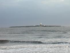
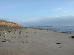
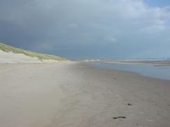
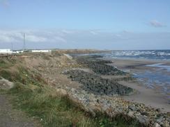
The initial stretch of this walk south from the campsite in Amble was highly enjoyable, as the vast majority of it was a walk along the long beach beside Druridge Bay. The time seemed to fly by as it often does when walking along long stretches of beach, and I put myself onto autopilot as I walked, concentrating mainly on the views and the sound of the waves breaking. On the very first stretch of the walk near Amble there were some superb views out to Coquet Island, the lighthouse being very prominent on the low profile island. Until the sixteenth century the island was use as a retreat by hermits and monks, and this made me wonder what life must have been like during a North Sea storm. The beach was deserted and I did not see anybody else until I neared Cresswell, and the sheer solitude and loneliness of the walk was quite spiritual. It is hard to imagine that behind the beach there used to be massive opencast coalmines, which have now been landscaped out of sight.
Once I reached the southern end of the bay near the little village of Cresswell, however, I was faced with a choice. I could either attempt to force my way along the foreshore south to Newbiggin-by-the-Sea, or I could follow roads and footpaths inland. The stretch of coast looked less than appealing, and I was unsure about whether or not I would be able to cross the River Lyne or get past the power station. In the end I decided that cowardice was the best option, and I chose to take the inland route. In the end this worked quite well, and there was much more to see as I walked along the road. It is obvious everywhere that the area has a massively industrialised past, and this feeling was enhanced when I came across my first sea coal pony. These were used until recent times to collect coal that had been dumped into the sea and had washed up on the shore; the coal has now gone but the ponies are still well looked after. I chatted to an owner of one pony for a few minutes, and he told me about how the soul of much of the community had been ripped out by the closure of the pits, and that people kept the ponies as a link with their past.
Lynemouth is dominated by heavy industry, in particular the aluminium smelting works and the associated power station. Now that the coalmines had closed coal has to be brought in to the power station by train; a very apt example of 'coals to Newcastle'. Although the closure of the mines has hit the area hard at least the smelting plant and power station are still operating; another coal mining area that I know of on the Derbyshire / Nottinghamshire border has no industry left after their pits closed. I managed to skirt the power station and join a footpath that went across a golf course, which seemed to me to be in a very strange location, overlooked as it was by the massive buildings of the power station.
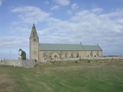
I stopped off for a lunch break at The Creswell Arms in Newbiggin-by-the-Sea. I was quite thirsty and I had a quick drink that was soon followed by another, slower one. I got chatting to the locals whom, after they had ascertained that I was not a Gypsy, were more than friendly. They asked me about the walk and I gave them details, and the conversation flowed as freely as the drink. I could easily have stayed longer, but I still wanted to walk a lot further today and so I set off to walk on. I did stop to have a quick look at the church in the village; this was quite an impressive, low structure and it was set well against the sea. From the church I joined the promenade that ran behind the sea wall, and followed this as it ran around Newbiggin Bay. The footpath south from the bay ran along the top of the cliffs, and it was obvious that this path is eroding away quickly. This was also obvious by the caravan site at the mouth of the River Wansbeck, and it left me wondering how long before the rest of the park followed.
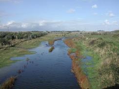
The last big diversion of the day was around the River Wansbeck. A footpath led up to the A89 road, and I used that bridge to cross the river. Once on the southern side I had to make a choice; whether to go down onto some wasteland and walk around the river, or whether to walk along roads instead. In the end I chose to do the latter, despite the fact that this meant that I had to walk further along the busy A189 dual carriageway. Once I had left the A189 I walked back along a minor road to the sea, and then down through Cambois, which was a quite boring plod with little of interest. Near the end of the walk I had to divert around the River Blyth to reach the first river bridge, and on the way I passed the North Blyth power station, which was in the process of being demolished. The dereliction and rubble of the half-demolished power station made quite a sad sight, and I was glad when I reached Sam in Mervan, who was waiting for me near the small hamlet of East Sleekburn.
Directions
This walk starts off at the Amble Links Holiday Park, which is on Links Road to the southeast of Amble. Leave the caravan site and turn right to start walking southeastwards along the road. After about a kilometre the road curves to the right beside a car park near High Hauxley, and here I turned left and walked the short distance to the beach just to the north of Hauxley Haven. Follow the beach southwards; initially there are some rocky outcrops in the sand, but these soon diminish in number and the going becomes easier. Continue southwards along the beach as it follows the wide sweep of Druridge Bay until a rocky outcrop called The Scars is reached at the southern end of the bay. Here leave the beach and climb up to the right and join the road in the little village of Cresswell.
Turn to the left and follow the road as it skirts the coast southwestwards to Snab Point, where it turns to head southwards for a couple of kilometres until it nears Lynemouth. The road crosses the River Lyne and swings around to the right to head northwestwards into the village. On entering the village take the first road off to the left, which heads southwestwards for a few hundred yards before ending at a T-junction. Turn left at this junction and follow another road that heads in a rough southeasterly direction for a little over a kilometre. The road slowly curves to the right and passes under a series of power cables between the power station and the aluminium works; here turn left down a road that leads to the power station.
The road passes under some freight sidings, and once on the other side immediately turn to the right down a footpath that heads southeastwards across some fields, before joining the edge of a golf course. The footpath ends after about a mile at the northern end of some terraced houses; here turn left and then right down a road that leads southwards through the village until the church is reached. At the church join the promenade that runs beside Newbiggin Bay, and when this ends join a local road and follow this southwards for a short distance until it ends. From here a footpath heads southwards, bypassing Spital Point but reaching the coast again soon afterwards.
The footpath runs along the top of some fast-eroding cliffs and passes though a caravan park before reaching the mouth of the River Wansbeck. Here the footpath swings around to the right and heads westwards for a little under a kilometre until the bridge that carries the A189 over the river is reached. Climb up onto the top of this bridge and use it to cross the bridge. On the other side carefully walk south along the dual carriageway for another few hundred metres until the road crosses a railway line and a minor road; here descend from the dual carriageway and join the minor road. Follow this eastward for about a kilometre until it reaches the seafront beside a car park, and then turn to the right to head southwards for a mile though Cambois. When the road meets a roundabout turn right and follow another road westwards for a couple of kilometres until a junction with the A189 road is reached, where this walk ends.
Distances
| From | To | Distance (m) | Ascent (ft) | Descent (ft) |
|---|---|---|---|---|
| Amble | Cresswell | 7.7 | 125 | 108 |
| Creswell | Newbiggin-by-the-Sea | 5.2 | 194 | 217 |
| Newbiggin-by-the-Sea | East Sleekburn | 6.1 | 341 | 312 |
This makes a total distance of 19.0 miles, with 660 feet of ascent and 637 feet of descent.
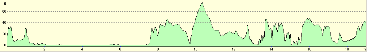
For more information on profiles, ascents and descents, see this page
Accommodation
We stayed at the Sandy Bay Holiday Park, which is at North Seaton, Ashington, Northumberland, NE63 9YD, and on the web at www.gbholidayparks.co.uk or telephone 0870 442 9310. This park had a swimming pool, which shut at 17.00 which was not much use for us, and a bar, which opened at 18.30 which was a little too late to be of use to us. Also, the toilet block was small, the showers dirty and, most unforgivably, the toilets had no toilet paper. Whilst they were in a better state than those at yesterday's site, at least there were signs that site was being improved, which is more than I can say for this site.
Disclaimer
Please note that I take no responsibility for anything that may happen when following these directions. If you intend to follow this route, then please use the relevant maps and check the route out before you go out. As always when walking, use common sense and you should be fine.
If you find any information on any of these routes that is inaccurate, or you wish to add anything, then please email me.
All images on this site are © of the author. Any reproduction, retransmissions, or republication of all or part of any document found on this site is expressly prohibited, unless the author has explicitly granted its prior written consent to so reproduce, retransmit, or republish the material. All other rights reserved.
Although this site includes links providing convenient direct access to other Internet sites, I do not endorse, approve, certify or make warranties or representations as to the accuracy of the information on these sites.
And finally, enjoy your walking!
This walk was mentioned in the following routes:
| My walk around the coastline of Britain |
Nearby walks
| # | Title | Walk length (miles) |
|---|---|---|
| 229 | Dunstan Steads to Amble | 15.5 |
|
|

|