Walk #678: Merstham to Otford
 |
 |
|
General Data
| Date Walked | 18/06/2005 |
| County | Surrey, Kent |
| Start Location | Merstham Station |
| End Location | Otford |
| Start time | 09.08 |
| End time | 18.00 |
| Distance | 23.2 miles |
| Description | This was a fairly uncomplicated stroll taking me east along the Downs Way. |
| Pack | Today I carried my 70-litre Craghoppers WildPlaces 70-litre rucksack, carrying spare clothes, laptop and a variety of other items, weighing about 20 kilograms. |
| Condition | I am fairly fatigued after this walk, not just because of the length of the day's walk but also due to the extreme heat. I have no blisters, although the underside of my left foot ached a great deal near the end. |
| Weather | Today was a hot and exceptionally sultry day, with temperatures forecast to reach over thirty-one degrees in London. There was a slight breeze that helped, and also some clouds in the sky that I was glad of, as it kept the sun off me. |
| OS map | Landranger number 187 (Dorking, Reigate & Crawley area) and Landranger number 188 (Maidstone & The Weald, Royal Tunbridge Wells) |
 |
 |
|
 |
 |
|
Map of the walk
Maps courtesy of Google Maps. Route for indicative purposes only, and may have been plotted after the walk. Please let me have comments on what you think of this new format. For a detailed table of timings for this walk, please see the table file.
 |
 |
|
 |
 |
|
Notes
After my superb walk along the first thirty five miles of the North Downs Way last weekend, I was very keen to get some more of it done. From looking at the maps it became obvious that a long weekend would allow me to get to Rochester, which would be the halfway point to Dover. I had hoped to get a place in the Youth Hostel at Kemsing, but as they were fully booked up I was forced to look in Otford instead. After a couple of phone calls I got a place in a B&B on Shoreham Road to the north of the village, which means that I will have to extend the walk slightly. With all of this in mind I drove from Cambridge down to Strood this morning, with a few patches of fog greeting me as I made my way down the M11. I had been expecting to arrive at Strood Station in time to catch the 07.54 to London Bridge, but the journey was better than I expected and I found a place to park my car in time to just catch the 07.24 service to London Bridge. I read my book on the train, and at London Bridge I had fifteen minutes in which to change trains. As I had only got a permit to travel at Strood I first had to get a full ticket for the journey, which turned out to be �14.40 for a single. This delayed me, and I had intended to nip into a shop and buy some batteries and some sun tan lotion. As it was I only just got on the Merstham train in time for it to leave.
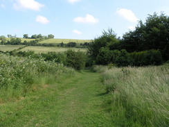
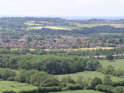
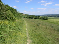
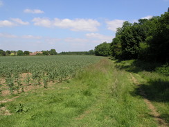
The train pulled into Merstham station at a few minutes past nine, and as I stepped off the train onto the platform it was already a baking hit day. I was wearing shorts and a t-shirt, with my Tilley hat protecting my head. I headed up to the main road through the village and walked around for five minutes looking for a shop that sold sun tan lotion; I failed in this, but in a newsagents I bought a chocolate bar and some crisps, and totally failed to forget to buy the batteries that I needed. This done, I munched the crisps as I headed back to rejoin the North Downs Way. This immediately headed past some rather smart houses before going over the M25 on a pedestrian bridge. Seeing the traffic rushing below me led me to think that I had chosen a much better way to spend the day, and as a local road took me eastwards I felt in quite a confident mood. A subway took me under the M23, and this was followed by a climb along a good track onto the top of the ridge. From the track at the top I got some superb views to then south and, unlike last Sunday's walk, these were not blocked by layers of trees. I diverted off the path slightly to visit a trig pillar, and then continued on eastwards.
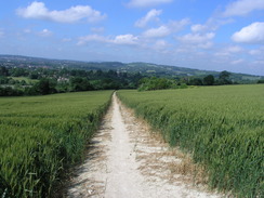
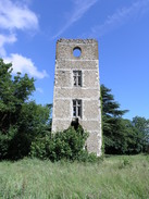
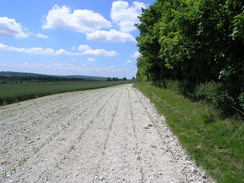
The paths under foot were of a good quality, and I soon found myself passing the immaculate garden of Willey Park Farm, and then turned to head southeastwards past Whitehill Tower. This is a majestically ruined tower, which has ivy artistically growing up the broken stonework. I could imagine that the views from the top would have been superb when it was complete, but it in its current state I doubt anyone will ever get to see them again. The path then continued onwards, skirting to the south of Oldpark Wood and Pilgrim Fort before heading through woodland to the A22 road. Here I reached a section of route that I had walked before last year during a circular walk; I felt as though I was on home ground as I strolled across the bridge and into the dark woodland on the other side. Unfortunately this was my undoing, as at a crossroads in the footpath I headed straight on instead of turning to the right, and ended climbing up steps, leading steeply uphill to the top of Winders Hill. In the heat it was a tiring climb, and when I emerged from the trees at the top of the hill it was obvious that I had taken the wrong route - not only could I not remember the steps from the previous walk, but the map showed clearly that the North Downs Way skirted along the side of the hill!
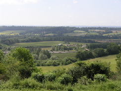
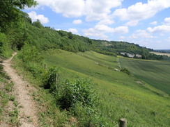
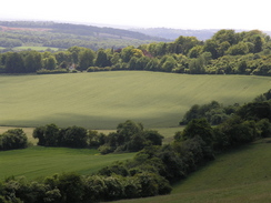
Cursing my stupidity I headed back down hill; it was not a long way, but the steepness of the steps took out a lot of energy that I would be needing later on. The Way continued on eastwards, heading through large patches of woodland and skirting the edge of a minor road before reaching some steps leading steeply downhill. From these steps I got a superb view along the arrow-straight railway line from Oxted, which runs under a tunnel directly beneath the steps. It was a view that I had enjoyed before, and I enjoyed it again, particularly as it was a sunny day and the views to the south were superb. At the bottom of the steps the path skirted the side of the escarpment eastwards, before dropping down to the valley floor as it passed a quarry. This stretch of path was very near to the M25 and the noise of the motorway was very intrusive, so I turned up the volume on my Walkman and plodded on. A stone marker marked the spot where the North Downs Way crossed the Greenwich Meridian, and soon after this I reached Pitchfont Lane, which climbed steeply uphill through the woods. The climb was fairly steep and in the heat I took my time on the climb, the sweat pouring off me as I hauled myself and my rucksack up the slope.
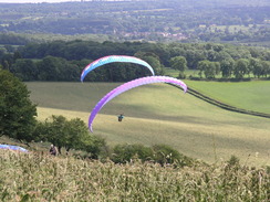
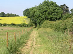
It seemed to take me an age to reach the top of the lane, where the path started skirting a road through woods eastwards, but once there I soon started speeding along once again. The tree covering overhead helped me to keep cool, and it was actually quite a pleasant stretch of path. Near Clarks Lane Farm I started to see paragliders overhead, and as I headed east towards Chestnut Avenue I passed them on the slopes below me. It was fascinating to see them use the thermals to inflate the parachutes and then take off, spiralling round as they slowly gained height. It was quite majestic, and I could not help but stop for a couple of minutes to watch them. By the time that I reached Chestnut Avenue, where the Way follows the road eastwards across the Surrey/Kent border, I was feeling very fatigued, and I started to look for somewhere to take a rest. A log outside a house proved to be rotten and full of ants, and so I walked on until I came to the junction with the A233 road. Here I finally found a good spot, and sat down on the grass beside the road, in the shade of the trees to my right. As my left foot was aching slightly I took my boots off so that I could massage the underside of them, which seemed to relieve the aching tremendously.
The rest was very pleasant, and I extended it slightly until I was bitten on the underside of my left knee by an ant. This persuaded me that it was finally time to leave, and so I got up and crossed the road to start following the path northeastwards. The path soon climbed steeply back up onto the top of the escarpment, and I found this climb easier due to the rest that I had just had. The views were good as the path continued on northeastwards along the top of the escarpment, before passing to the south of some tall transmitters, where it headed away from the edge of the escarpment. The section of path to the south of Knockholt Pound followed the edge of some woodland and was, frankly, boring, so I was relieved when this finished and the path started descending down towards the M25. The view to the southeast during the descent were marvellous, and even the nearby motorways did not intrude on the scene too much. After skirting Turvin's Farm the path left fields and followed the B2211 northeastwards for about half a mile until it reached the A224. The M25 was then crossed for the final time using the road bridge, and it was left behind as the road headed southeastwards down towards the M2 and Dunton Green.
By this stage fatigue was starting to set in, and at the road junction where the Way left the A224 I was relieved to find a nice pub. Despite being late afternoon it was still exceedingly hot, and as I was concerned about sunstroke I decided that having alcohol would not be a good idea. Instead I settled down on a chair with a pint of orange and lemonade that washed down a pack of crisps; I also asked for a pint of water. There was still some water left in my water bottles, but I wanted to use every opportunity possible to get more liquid on board. The landlady in the pub was very friendly and quite generous, and I left the pub in a much better frame of mind. A little further on the path left a road and headed past Donnington Manor Hotel, outside of which I saw a crowd of people beside the path in the shade of trees. There were a few tables out and I soon realised that it was a wedding party making the most of the sun. As I walked past I remarked that getting married was a much better use of the day than walking, and in response they invited me to take a photo of the happy couple. This I did, but I felt obliged to reject their kind offer of a glass of wine, as I knew that I had a long way to go and that the alcohol would just dehydrate me more.
This put me in an even better mood as I headed along the path as it crossed fields, before descending down to cross a railway line on a bridge. The afternoon was turning into a glorious evening as I approached the western side of the village of Otford, I had been hoping to find a shop where I could purchase some suntan lotion and batteries, but as I followed the road that runs through the centre of the village eastwards I was increasingly perplexed as I failed to find one. I passed one newsagents, but that was shut, and when I eventually reached the railway station I realised that I had passed through the entire length of the village without finding one. There was little left for me to do except walk northwards along Shoreham Road towards the B&B that I had booked into; this turned out to be right on the northern edge of the village and, once the pavement ended, I was forced to walk carefully along the busy road.
I was therefore relieved when I found the B&B, and I arrived at the front door just as another guest, a Canadian lady, was unloading her car. The landlady made me feel instantly very welcome, and after having shown me my room I took my rucksack off and ran a bath for a long soak. The room was perfect; the landlady had opened the windows to let the heat out, and this meant that the temperature inside was much more comfortable than it had otherwise been. She also offered to run me down into the village for an evening meal, but due to fatigue I decided to forego this. Instead I went to bed, and whilst typing up these notes watched the last episode of this series of Doctor Who and, afterwards, as fascinating documentary on the development of the Airbus A380 airliner. Once I switched the light off sleep thankfully came quickly and easily despite the hot night; the day's walk had truly tired me out.
 |
 |
|
 |
 |
|
Directions
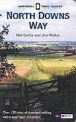
The walk is also covered in detail in the North Downs Way National Trail Guide, by Neil Curtis and Jim Walker, ISBN 1 85410 853 0, published by Aurum Press Ltd.
The only exception to this is at the end of the walk; once the station in Otford is reached continue on for a few yards to a road junction, and then turn to the left to start walking northwards up Shoreham Road. The B&B that I stayed at is three-quarters of a mile away up the road, just before some traffic speed restriction signs.
 |
Distances
| From | To | Distance (m) | Ascent (ft) | Descent (ft) |
|---|---|---|---|---|
| Merstham Station | A22 | 5.5 | 768 | 528 |
| A22 | Botley Hill | 5.0 | 1247 | 968 |
| Botley Hill | Knockholt Pound | 7.6 | 797 | 942 |
| Knockholt Pound | Otford Station | 4.4 | 246 | 650 |
| Otford Station | Otford B&B | 0.7 | 33 | 82 |
This makes a total distance of 23.2 miles, with 3091 feet of ascent and 3170 feet of descent.
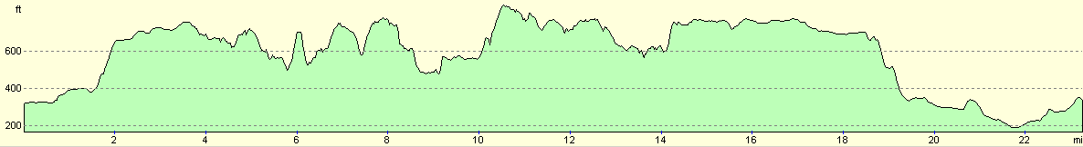
For more information on profiles, ascents and descents, see this page
Accommodation
I spent the night at a B&B called Darenth Dene, Shpreham Road, Otford, tel. (01959) 522293. This was an exceedingly nice B&B that cost me thirty pounds for the night. The landlady made me feel very welcome, and the room that I stayed in was particularly nice.
Disclaimer
Please note that I take no responsibility for anything that may happen when following these directions. If you intend to follow this route, then please use the relevant maps and check the route out before you go out. As always when walking, use common sense and you should be fine.
If you find any information on any of these routes that is inaccurate, or you wish to add anything, then please email me.
All images on this site are © of the author. Any reproduction, retransmissions, or republication of all or part of any document found on this site is expressly prohibited, unless the author has explicitly granted its prior written consent to so reproduce, retransmit, or republish the material. All other rights reserved.
Although this site includes links providing convenient direct access to other Internet sites, I do not endorse, approve, certify or make warranties or representations as to the accuracy of the information on these sites.
And finally, enjoy your walking!
This walk was mentioned in the following routes:
| The North Downs Way |
Nearby walks
| # | Title | Walk length (miles) |
|---|---|---|
| 217 | Greenwich to Whyteleafe | 17.9 |
| 599 | A circular walk from Westhumble to Surrey's highest point | 20.0 |
| 601 | A circular walk along the North Downs from Whyteleafe | 21.6 |
|
|

|