Walk #231: East Sleekburn to Howdon
 |
 |
|
General Data
| Date Walked | 10/10/2002 |
| County | Northumberland, Tyne and Wear |
| Start Location | East Sleekburn |
| End Location | Howdon Station |
| Start time | 09.00 |
| End time | 16.54 |
| Distance | 18.0 miles |
| Description | This was a pleasant mixture of road and beach walking southwards towards the centre of Newcastle-upon-Tyne. |
| Pack | Today I carried my 30-litre Karrimor HotRock rucksack, which was filled with my packed lunch, waterproof coat, water bottle and a couple of spare shirts, together with the usual assortment of odds and ends. |
| Condition | I feel absolutely fine after this walk, but I would not necessarily have wanted to walk much further today. The problem that I had yesterday with my right foot did not recur, and I had no other problems of any note. |
| Weather | As with the previous two days the wind was the most notable factor of today's walk. The previous night it had been very windy, and the caravan had been blown about and the sight of the waves this morning was impressive. About midway through the morning whilst I was walking along the beach it had tried to rain, but the light drizzle was not enough to force me to put my coat on. The wind was quite cold at times, but thankfully I did not get as cold as I did on the previous two days. |
| OS map | Landranger number 81 (Alnwick, Morpeth & surrounding area) and Landranger number 88 (Newcastle Upon Tyne, Durham & Sunderland) |
 |
 |
|
 |
 |
|
Map of the walk
Maps courtesy of Google Maps. Route for indicative purposes only, and may have been plotted after the walk. Please let me have comments on what you think of this new format. For a detailed table of timings for this walk, please see the table file.
Notes
When I woke up this morning I was not particularly looking forward to this walk, as it signalled the entry proper into the industrialised northeast. This involved heading towards the first city since I started the walk in Edinburgh, which seems like an inordinately long time ago already. Thus I set off fairly late, as I found it hard to inspire myself ready for the walk. This happens to me occasionally, I know that the only thing that I can really do is just set out and do the walk; the more I prevaricate the less I really want to do the walk.
My first problem of the day was the crossing of the River Blyth. Fortunately the Kitty Brewster Bridge, which carries the A190 dual carriageway over the river, was a short distance away from where I ended yesterday's walk near East Sleekburn, and so I set off along a road across the Sleek Burn, after which I attempted to pick up a footpath that led across fields towards Mount Pleasant Farm. Unfortunately I found this footpath almost impossible to trace on the ground, and after much floundering around I decided to make my way back towards the A189 so that I could pick up a footpath that ran southwards beside the road towards the bridge. This annoyed me immensely, and out me in a bad mood for the next few hours; I rally hate having to change my route due to not being able to find footpaths; particularly when the alternative route is beside a noisy and smelly main road.
Eventually I found my way onto the slip road that led up onto the Kitty Brewster Bridge. Fortunately there was a footpath on the eastern side of the bridge that allowed me to get over to the other side without trying to mingle with the traffic, and this continued on the other side until I reached a junction with the A193 road. The walk eastward into Blyth was most unremarkable, and involved much more road plodding; a sure sign of the way things are probably going to be for the next couple of days. I found Blyth to be dirty, squalid and quite run-down, although that may have been a sign of my mood than anything else. I was not keen to hang around, and so I did not stop and just kept on walking south along the B1329.
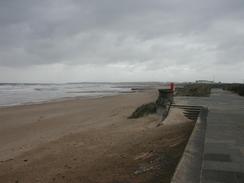
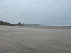
As I headed south out of Blyth the area slowly improved, although the first mile or so was impressively industrialised. Eventually the warehouses on my left finished, and I could gain access to the long stretch of beach that leads down to the village of Seaton Sluice. This was quite an enjoyable walk, and I was annoyed when the beach ended at the Seaton Burn and I had to climb up and join a road through the village. The harbour in the village is quite small but not very picturesque, and the village got named by the means of clearing the silt from it; upstream the burn would be blocked using sluice gates, and once a sufficient head of water had been built up it would be released downstream in a torrent sufficient to clear the harbour.
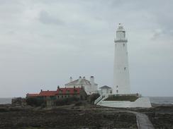
I walked quickly through the village and, shortly before I let it, I joined a footpath that headed around to Crag Point and then on around the cliffs towards St Mart's Island, on which stands a lighthouse. I was surprised to see that the lighthouse was open to the public (since automation of the lighthouses most have been closed to the public), and I was sorely tempted to go up it, but I was also keen to press on. Instead I stopped near the car park to have a look at the island and lighthouse, which is in a remarkably pretty setting. People were going to and fro across the causeway that leads to the island, looking like little ants in the distance. We were spending the night at the nearby campsite, so I walked the short distance to it and met Sam there for lunch.
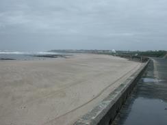
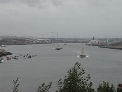
Unfortunately the lighthouse proved to be the last scenic section of today's walk, and the rest of it proved to be along the promenade and roads south through Whitley Bay and on to Sharpness Point and the River Tyne at Tynemouth. Some parts of Tynemouth were surprisingly nice, and I enjoyed looking around the area between the castle and the ruins of the priory. The views from here over the North Pier and the mouth of the River Tyne to South Shields were nice, and it was a good place for loitering around. I did not want to pay to go around the ruins of the castle, and so I descended to join a cycle path that runs westwards along the promenade past the Black Middens and on towards Clifford's Fort.
I had not planned a route through Tynemouth, and all I knew was that I intended to end the walk near to the northern entrance to the Jarrow foot tunnel in Howdon, where I could get the Tyne and Wear Metro back to Whitley Bay. This involved much road walking, although I did enjoy the hustle and bustle around Fish Quay, where I was surprised to find a massive whale jawbone standing on-end outside a pub! The rest of the walk was fairly nondescript, and I was glad when I reached the station at Howdon, and the end of the day's walk.
Directions
This walk starts off by a road junction with the A189 road immediately to the north of East Sleekburn. Just before the road junction turn left down a road that heads for a couple of hundred metres south into the village of East Sleekburn, and then follow it as it curve slightly to the right and crosses over the Sleek Burn. On the southern side of the burn the maps show a footpath heading off across fields southeastwards to Mount Pleasant Farm, but I could not find this path and so continue on along the road; when a farm track leads off to the left join it and follow it as it parallels the road southwards. When the track curves to the left turn right and leave the track, crossing an area of land before gaining access to a slip road leading from the A189 road. Follow the slip road southwards as it climbs up and joins the A189 road, and then use the pavement to cross the River Blyth via the Kitty Brewster Bridge.
On the southern side of the bridge continue straight on along the A189 road as it passes under a series of power lines; when a slip road heads off to the left follow it as it climbs up to meet a roundabout with the A93 road. At the roundabout turn to the left and follow the road eastwards as it almost immediately meets another roundabout. Continue straight on down the A193 and follow the road as it heads eastwards, passing a large industrial area. About a mile later a footpath leads off to the left along a track opposite a church in a crematorium; do not take the footpath that heads northwards, but the one that heads northeastwards before curving around to meet the B1329 road in Blyth. Join the B1329 and follow it as it heads through the town, passing three roundabouts before curving to head southwards.
Follow the B1329 south as it heads out of the town, passing a series of warehouses on the left. Once the warehousing ends turn to the left and walk the short distance to the beach, and then turn to the right to walk southwards along the beach for about there miles. When the mouth of the Seaton Burn is reached, turn right and climb up to meet the A193 road. Turn left along the A193 and follow it as it climbs over the burn, and once on the other side take a road that leads off to the left and which curves around to head southwards. Just before this road meets up with the A193 once again turn left down a footpath that leads along a track for a short distance before leaving it and heading on to Crag Point; here the path curves to head southwards past Hartley and then on southeastwards to the car park opposite St Mary's Island. Continue on through the car park and rejoin the footpath as it curves around to meet the A193 immediately to the north of Whitley Bay.
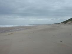
Instead of joining the A193 either walk along the beach or the promenade that runs beside it as they run southwards beside Whitley Sands. If you followed the beach then when it ends in Whitley Bay climb up onto the promenade and then continue along this. When the promenade itself ends, then follow the coast road past the lifeboat station into Cullercoats. Here descend form the road and go down onto the Long Sands and then walk south along the beach for about a kilometre until it ends at Sharpness Point, where a path climbs up back onto the top of the cliffs. At the top follow the clifftop road south for about five hundred metres until the castle and ruined priory are reached, and then descend down to the mouth of the River Tyne near the Black Middens.
Once the promenade is met turn right and walk westwards along it, passing the Black Middens and continuing on towards Fish Quay. Here my directions got slightly confused; I climbed uphill and followed roads westwards until I joined the A187 road. Follow this road southwestwards for a couple of kilometres past Percy Main, and then turn right along a road that heads northwards for a little under a kilometre until it ends at the A193 road, passing Percy Main Station on the way. At the A193 turn left and follow the road westwards, crossing the junction with the 187 and then almost immediately the A19(T). Continue straight on along the A193 for about half a kilometre and then take a road that leads off to the left, heading down to Howdon Station, where this walk ends.
Distances
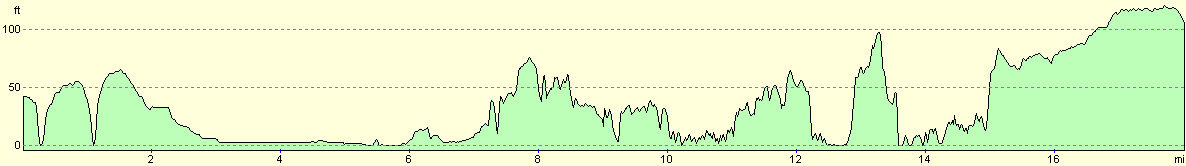
| From | To | Distance (m) | Ascent (ft) | Descent (ft) |
|---|---|---|---|---|
| East Sleekburn | Blyth Church | 4.0 | 125 | 164 |
| Blyth Church | Seaton Sluice | 3.5 | 128 | 85 |
| Seaton Sluice | Tynemouth | 6.0 | 627 | 669 |
| Tynemouth | Howdon Station | 4.5 | 240 | 131 |
This makes a total distance of 18.0 miles, with 1120 feet of ascent and 1049 feet of descent.
For more information on profiles, ascents and descents, see this page
Transport
I used the Tyne and Wear Metro to get back to Whitley Bay Station, and from there I got a bus the short distance to the campsite.
Accommodation
We stayed at the Whitley Bay Holiday Park, which is just off the A193 road to the north of Whitley Bay. Their full address is Whitley Bay Holiday Park, The Links, Whitley Bay, Tyne and Wear, NE26 4RR, and they have a web presence at www.gbholidays.co.uk. It cost us thirteen pounds to camp here for the night. This campsite was run by the same people as last night's, and I have about the same comments - when I called in here at lunchtime to visit Sam the toilets were in an awful state, and although the site is quite neat and tidy I was generally not very impressed.
Disclaimer
Please note that I take no responsibility for anything that may happen when following these directions. If you intend to follow this route, then please use the relevant maps and check the route out before you go out. As always when walking, use common sense and you should be fine.
If you find any information on any of these routes that is inaccurate, or you wish to add anything, then please email me.
All images on this site are © of the author. Any reproduction, retransmissions, or republication of all or part of any document found on this site is expressly prohibited, unless the author has explicitly granted its prior written consent to so reproduce, retransmit, or republish the material. All other rights reserved.
Although this site includes links providing convenient direct access to other Internet sites, I do not endorse, approve, certify or make warranties or representations as to the accuracy of the information on these sites.
And finally, enjoy your walking!
This walk was mentioned in the following routes:
| My walk around the coastline of Britain |
Nearby walks
| # | Title | Walk length (miles) |
|---|---|---|
| 230 | Amble to East Sleekburn | 19.0 |
| 232 | Howdon Station to Sunderland Station | 15.3 |
| 931 | Hadrian's Wall Path: Chollerford to Newcastle | 26.9 |
|
|

|