Walk #519: Lochinver to Clashnessie
 |
 |
|
General Data
| Date Walked | 05/08/2003 |
| County | Highlands |
| Start Location | Lochinver |
| End Location | Clashnessie |
| Start time | 09.24 |
| End time | 16.27 |
| Distance | 19.5 miles |
| Description | This was a lovely day's walk, and some of the views were spectacular. |
| Pack | Today I carried my 30-litre Karrimor HotRock rucksack, which was filled with my packed lunch, waterproof leggings, water bottle and a couple of spare shirts, together with the usual assortment of odds and ends. |
| Condition | Aside from a little chaffing I feel absolutely fine after this walk, and I could easily have walked further if I had needed to. My shoulder and neck were fine, which is a relief. |
| Weather | Today was a hot and sunny day, and one of the hottest of the year so far. There was little wind, and I was grateful of the little cloud that there was for keeping the temperatures down a bit. |
| OS map | Landranger number 15 (Loch Assynt, Lochinver & Kylesku) |
 |
 |
|
 |
 |
|
Map of the walk
Maps courtesy of Google Maps. Route for indicative purposes only, and may have been plotted after the walk. Please let me have comments on what you think of this new format. For a detailed table of timings for this walk, please see the table file.
 |
 |
|
Notes
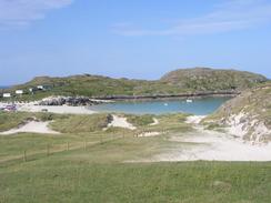
For the first part of this walk I had absolutely no energy, and found the miles hard to cover. The path that I had to walk over to get to Achmelvich was good, and this helped me keep up a reasonable pace despite my tiredness. The views from the path were beautiful, with several mountains sticking up to the southeast and east. Eventually I dropped down to a road that I followed into Achmelvich. This was a nice little area that is being conserved after much of the beach and dune system disappeared due to erosion caused by man, and it was a good to see that the factors that caused the erosion were being fixed.
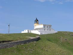
The only negative point about the area was that there was a campsite right by the beach, and this spoiled the views from higher up on the cliffs. From Achmelvich another good path took me to the B869 road in Alltanabradhan, which I followed northwestwards to Clachtoll, where Sam was waiting for me. As the next few miles were along roads I decided to change into my trainers, and this helped me speed along a fairly unappealing stretch of road to the lighthouse near Stoer Point. I met Sam yet again at the lighthouse near Rubha Stoer, where she was chatting to a couple who had six Siberian Huskies with them - it was hot enough for me, and I wonder how dogs more designed for the cold of Alaska must have felt! Instead of sandwiches for lunch I had the left over Bolognese from dinner last night - absolutely superb.
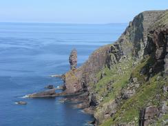
Sam wanted to walk with me to the Old Man of Stoer, to which there is a reasonably good path, but after a mile she was finding the terrain hard and so she turned back. The stack that is the Old Man of Stoer is quite nice, but I have seen many such stacks on this trip, and hat took some of the gloss of this one. Instead of walking around to the Point of Stoer I climbed uphill to the 161-metre high summit of Sidhean Mor. The view from the top was spectacular, with an array of mountains arrayed out to the southeast and the coastline stretching away in two directions. Unfortunately I had to change my initial plan of using the trig point as a base for my camera tripod, as it was covered in thousands of flying ants. I had planned to take a panoramic photo of the mountains, but although I did this it was a bit to hazy for the resultant photograph to be very good.
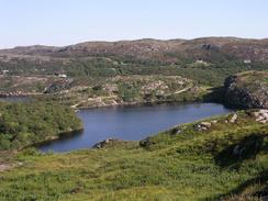
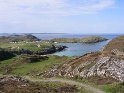
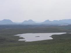
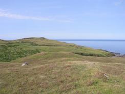
The next stretch of walk was across some lovely moorland to the road at Culkein, and I enjoyed this stretch of the stroll. The moorland was not too wet, and I diverted inland slightly from the cliffs and I passed near to the little Loch an Achaidh. The gradients were not too steep, and I cannot express how much I enjoyed the walk. With hindsight I wish that I had followed the cliffs around to Culkein, but I hit a road near a farm and followed it for about a mile and diverting over the hills to the east of Achnacarnin. A steep descent took me down to meet the end of another road, which I could follow southwards to the B869 road in Clashnessie.
When I arrived at Clashnessie Sam was waiting for me outside Mervan. She was keen to have a barbecue, and so after I had a little rest Sam went down to the beach to light the barbecue whilst I sat back and read, relaxing after the hot day. Suddenly Sam called for me, and when I got down to the beach I found that she was talking to the wife of John, an ex-colleague of mine from Cambridge. John soon arrived, and we had a little chat as we cooked. Sam and I then ate, and afterwards went for a paddle in the water. The water was not too cold, but it naturally hurt when the saltwater reached my chafed skin. There was lots of life in the water, from small flatfish camouflaging themselves against the sandy bottom, to eels and jellyfish. It was a nice diversion for fifteen minutes or so, after which we retired back to Mervan and then went to chat to John and family for an hour. It is an amazing coincidence to bump into someone I used to work with in such a remote place, and even more of a coincidence that the motorhome that they were staying in was parked only a hundred yards from ours. Talking to people from Cambridge made me quite nostalgic and not a little homesick, and I think that once the walk is over I may go back there for a while to visit.
Tomorrow I have a long road walk along the B869 road eastwards to Kylesku, which I am quite looking forward to. If it is as hot as it was today then I will be extremely tempted to walk without a shirt on for the first time on this trip, if only to try and keep myself cooler on the ascents. At Kylesku I shall be joining a route that I have walked before, and I am quite looking forward to it - the scenery on the walk north to Cape Wrath is going to be fantastic, particularly if the weather is good.
Directions
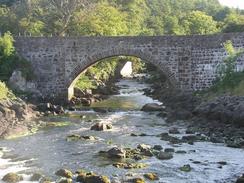
This walk starts off at the Culag Hotel in Lochinver. Leave the hotel car park and turn right down the road for a couple of hundred yards, and follow the road as it curves to the left to head north past the seafront in Lochinver. Continue past a memorial until a road junction is met on the left. Turn left and follow the road as it crosses the River Inver and heads westwards for about a mile past Badidarach, where the road curves to the right to head northwestwards. Near a little house a path lead off to the left, climbing past a house and then continuing up and down along a clear path westwards. It slowly descends towards Ardroe before joining a track that heads northwards past the western shore of Loch Dubh and crossing a narrow stretch of Loch Roe on a bridge. The track then ascends before ending at a road.
Turn left to head westwards for a little over a mile towards the campsite at Achmelvich, passing the youth hostel on the way. Just past a phone box turn right down a track that leads into a car park, and then take a footpath that heads north out of the car park, climbing up and down past a mill before reaching a track at Alltanabradhan. Turn right down this track for about fifty yards and then turn left to join the B869 road. Follow the road as it climbs uphill to the northwest towards Clachtoll, where it descends to pass a campsite and turns to head northwards through Stoer. The road passes Lochan Sgeireach and then turn left along a road that heads through Totag. A slightly hidden road junction leads off to the left and heads westwards through Balchladich towards Balchladich Bay, where it turns to the right to head northwards before ending at a T-junction. At the junction turn left and hhead westwards through Raffin to a car park by the Stoer lighthouse.
A footpath leads off to the right from the car park, heading northwards along the cliffs. The path is very distinct although it does branch in places. It descends into a valley and up the other side and continues on until it reaches the Old Man of Stoer. Instead of walking around to the very northernmost part of the Point of Stoer I turned right and climbed uphill to the trig point on Sidhean Mor. From the trig point I headed southeast, skirting the edge of the cliffs and then heading along the moorland to the east of Loch an Achaidh before meeting the end of a road near a farm. Head south along this road for about half a kilometre, and when it ends at a T-junction turn left to the bay of Culkein. Continue along the road as it curves to head southwards, and as it heads uphill leave the road and climb uphill to the left to meet another road at the top of a hill.
Turn left and follow the road until it ends, and when it does turn right and descend steeply downhill into a valley near the little isle of Sgarbhag. Pass a little cottage and then climb uphill steeply once more to the south, before descending down to meet the end of a road near a couple of houses. Join this road and follow it as it climbs uphill to the south for a little under a kilometre until it ends at a T-junction with the B869 road. At the junction turn left and descend down the hill to a car park by Clashnessie Beach, where this walk ends.
Distances
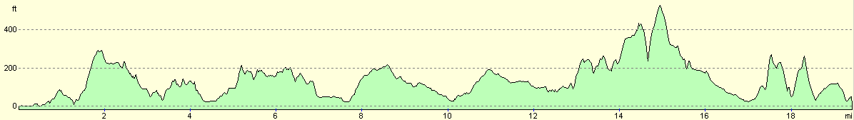
| From | To | Distance (m) | Ascent (ft) | Descent (ft) |
|---|---|---|---|---|
| Lochinver | Clachtoll | 7.2 | 1243 | 1198 |
| Clachtoll | Point of Stoer lighthouse | 5.7 | 574 | 505 |
| Point of Stoer lighthouse | CLashnessie | 6.6 | 1539 | 1644 |
This makes a total distance of 19.5 miles, with 3356 feet of ascent and 3347 feet of descent.
For more information on profiles, ascents and descents, see this page
Accommodation
We parked Mervan in the little car park right beside the beach in Clashnessie, which was a beautiful place to park. There were no facilities nearby, but fortunately we really did not need anything.
Disclaimer
Please note that I take no responsibility for anything that may happen when following these directions. If you intend to follow this route, then please use the relevant maps and check the route out before you go out. As always when walking, use common sense and you should be fine.
If you find any information on any of these routes that is inaccurate, or you wish to add anything, then please email me.
All images on this site are © of the author. Any reproduction, retransmissions, or republication of all or part of any document found on this site is expressly prohibited, unless the author has explicitly granted its prior written consent to so reproduce, retransmit, or republish the material. All other rights reserved.
Although this site includes links providing convenient direct access to other Internet sites, I do not endorse, approve, certify or make warranties or representations as to the accuracy of the information on these sites.
And finally, enjoy your walking!
This walk was mentioned in the following routes:
| My walk around the coastline of Britain |
Nearby walks
| # | Title | Walk length (miles) |
|---|---|---|
| 518 | Altandhu to Lochinver | 18.9 |
|
|

|