Walk #312: Southbourne to Hamworthy Station
 |
 |
|
General Data
| Date Walked | 30/12/2002 |
| County | Dorset |
| Start Location | Southbourne |
| End Location | Hamworthy Station |
| Start time | 09.22 |
| End time | 15.23 |
| Distance | 15.3 miles |
| Description | This walk comprised of a long walk along the promenade and beach through Bournemouth that was followed by a road walk through to and beyond Poole. |
| Pack | Today I carried my 30-litre Karrimor HotRock rucksack, which was filled with my packed lunch, waterproof leggings, water bottle and a couple of spare shirts, together with the usual assortment of odds and ends. |
| Condition | I feel absolutely fine after this walk, and could have walked further if the need had arisen. My ankle gave me absolutely no trouble, and nothing else ached. |
| Weather | The forecast for today was for heavy rain, and it rained for most of the night, which meant that the campsite was one gigantic puddle this morning. Fortunately this did not happen to be the case, and aside form one short shower of drizzle the day remained dry. The wind was also much less powerful than it had been yesterday, and at times the sun even made an appearance. All in all this could have been a much worse day. |
| OS map | Landranger number 195 (Bournemouth & Purbeck, Wimborne Minster & Ringwood) |
 |
 |
|
 |
 |
|
Map of the walk
Maps courtesy of Google Maps. Route for indicative purposes only, and may have been plotted after the walk. Please let me have comments on what you think of this new format. For a detailed table of timings for this walk, please see the table file.
 |
Notes
I had a late start to today's walk, as I had spent a long time getting a CD ready so that the website could be updated. This had to be followed by the drive from the campsite to the start of the walk, and so it was nearly nine thirty before I finally set off. This led to me being worried about the time all day, and consequently I did not take as many stops as I wanted and I feel fairly tired. I am also disappointed about the distance that I have walked, as I hoped that I could have walked much further today.
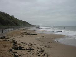
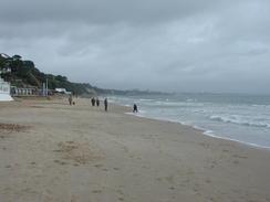
The long promenade made the first part of this walk fairly straightforward and also slightly boring, as it was simply a case of sticking to the path as it headed along the seafront. Eventually it petered out, and I had to walk along the beach to reach North Haven Point, from which the ferry operates across the harbour mouth. The beach disappeared for last part of this route past the large Haven Hotel, and I was forced to walk on the concrete foreshore beside the seawall past the hotel. This went well except for the very last ten yards, when the wall was covered in a black goo and seaweed. I suddenly realised that my feet were both slipping in unison down the slight slope towards the sea, so I stopped moving. My feet stopped slipping, but every time that I tried to move a foot it would slip down. This caused me to flail my arms in the air like a madman whilst I tried to keep my balance and gained me a small crowd of spectators. I stopped moving again so I could think about the problem, only to slip down another few inches towards the crashing waves. Eventually I just threw myself down onto the upper slope above me (which was fortunately not covered in the goo) so that I could drag myself up and make my way the last few yards to safety. This must have been quite entertaining for the onlookers as I got a small round of applause!
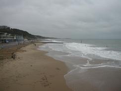
As I was walking along the promenade the sea was quite rough, and as it was high tide some waves were breaking over the wall and onto the promenade. The sight of the waves doing this was quite mesmeric, and whenever I reached a spot where the waves were doing this I would stop and watch them. It must have been a good day for surfing, as there were a couple of dozen surfers in the water in total enjoying the waves - although I could think of better things to do than to swim in the sea in winter!
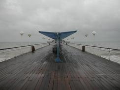
The two piers that I passed today were quite nice - Boscombe Pier probably being nicer than Bournemouth, although there was not much in it, and it was nice to see piers being used and not in ruin. I say this because headline news in the south is that part of Brighton West pier fell into the sea yesterday. I passed that pier a couple of weeks ago and expressed my dismay at its condition; it is now in a much worse state with half of the ballroom hanging over the sea. It is a Grade One listed structure and apparently the most historic pier in the world, and plans were fairly well advanced to repair the structure that was last used in 1975. I do not know what will happen to it now, but I can only imagine that it will cost much more to repair.
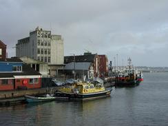
By the time that I reached Poole I was in need of a rest so I nipped into the Poole Arms so that I could have a sit down. Whilst I was in I had a quick pint and chatted to the barmaid. The rest was much needed, although when I restarted the walk I found it quite hard to get going again, and once I was going I reached a lift bridge that I stopped to photograph as it went up. This caused me to stop again for a few minutes, and made it hard for me to restart once again.
My brother and sister in law are coming down to visit tomorrow night to celebrate the New Year and her birthday. It should be a very good evening, and I am looking forward to seeing the first member of my family for three months. Sam has booked us into a campsite that has a bar, so I shall probably be seeing the New Year in with some alcohol.
Directions
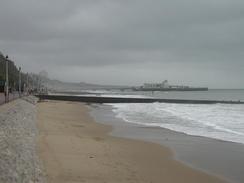
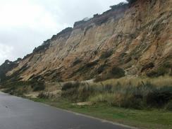
This walk starts off on the road at the top of the cliffs in Southbourne. The first part of this walk is exceedingly easy; just descend from the road down onto the promenade beside the sea and turn right to follow it westwards. The promenade passes through Bournemouth and then turns to a more southwesterly heading as it enters sandbanks. Here the promenade ends and I followed the beach around to the hotel beside the landing place for the ferry from South Haven Point.
At the ferry turn right up the approach road and then turn left along the B3369 road. This road curves around Sandbanks before heading eastwards and nearly meeting the promenade once again - if you wanted to shorten the walk by missing off Sandbanks then this is the place to rejoin the road. The road curves around to head in a more northerly direction around the eastern edge of the Main Channel. Follow the road as it passes the marina and then follow a cycle path that heads off to the left to head westwards around Parkstone Bay.
The cycle path meets a car park before ending at a road. Turn left down this road and follow it alongside the water and past a little marina in Poole before ending at the A350 road. Turn left to cross the lift bridge and follow the road as it curves to the right and becomes the B3068 road. Follow this road northwestwards for a couple of miles until it passes under a railway bridge. On the other, northern, side of the bridge turn left along a road. Almost immediately turn down another road to the left that leads to Hamworthy Station, where this walk ends.
Distances
| From | To | Distance (m) | Ascent (ft) | Descent (ft) |
|---|---|---|---|---|
| Southbourne | North Haven Point | 8.1 | 502 | 561 |
| North Haven Point | Hamworthy | 7.2 | 203 | 174 |
This makes a total distance of 15.3 miles, with 705 feet of ascent and 735 feet of descent.
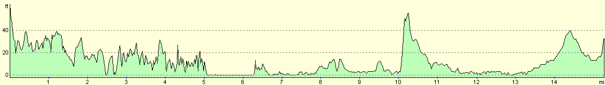
For more information on profiles, ascents and descents, see this page
Accommodation
We parked on the roadside near the station, which means that I shall be able to have an early start tomorrow for what could be a long day. It was a quiet enough evening, with the occasional trains not bothering me too much.
Disclaimer
Please note that I take no responsibility for anything that may happen when following these directions. If you intend to follow this route, then please use the relevant maps and check the route out before you go out. As always when walking, use common sense and you should be fine.
If you find any information on any of these routes that is inaccurate, or you wish to add anything, then please email me.
All images on this site are © of the author. Any reproduction, retransmissions, or republication of all or part of any document found on this site is expressly prohibited, unless the author has explicitly granted its prior written consent to so reproduce, retransmit, or republish the material. All other rights reserved.
Although this site includes links providing convenient direct access to other Internet sites, I do not endorse, approve, certify or make warranties or representations as to the accuracy of the information on these sites.
And finally, enjoy your walking!
This walk was mentioned in the following routes:
| My walk around the coastline of Britain |
Nearby walks
| # | Title | Walk length (miles) |
|---|---|---|
| 311 | Milford on Sea to Southbourne | 16.9 |
| 313 | Hamworthy Station to South Haven Point | 18.0 |
| 314 | South Haven Point to Worth Matravers | 16.7 |
|
|

|